Upgrade to Pro — share decks privately, control downloads, hide ads and more …

MapStore, a year in review FOSS4G 2022 edition

MapStore, a year in review FOSS4G 2022 edition

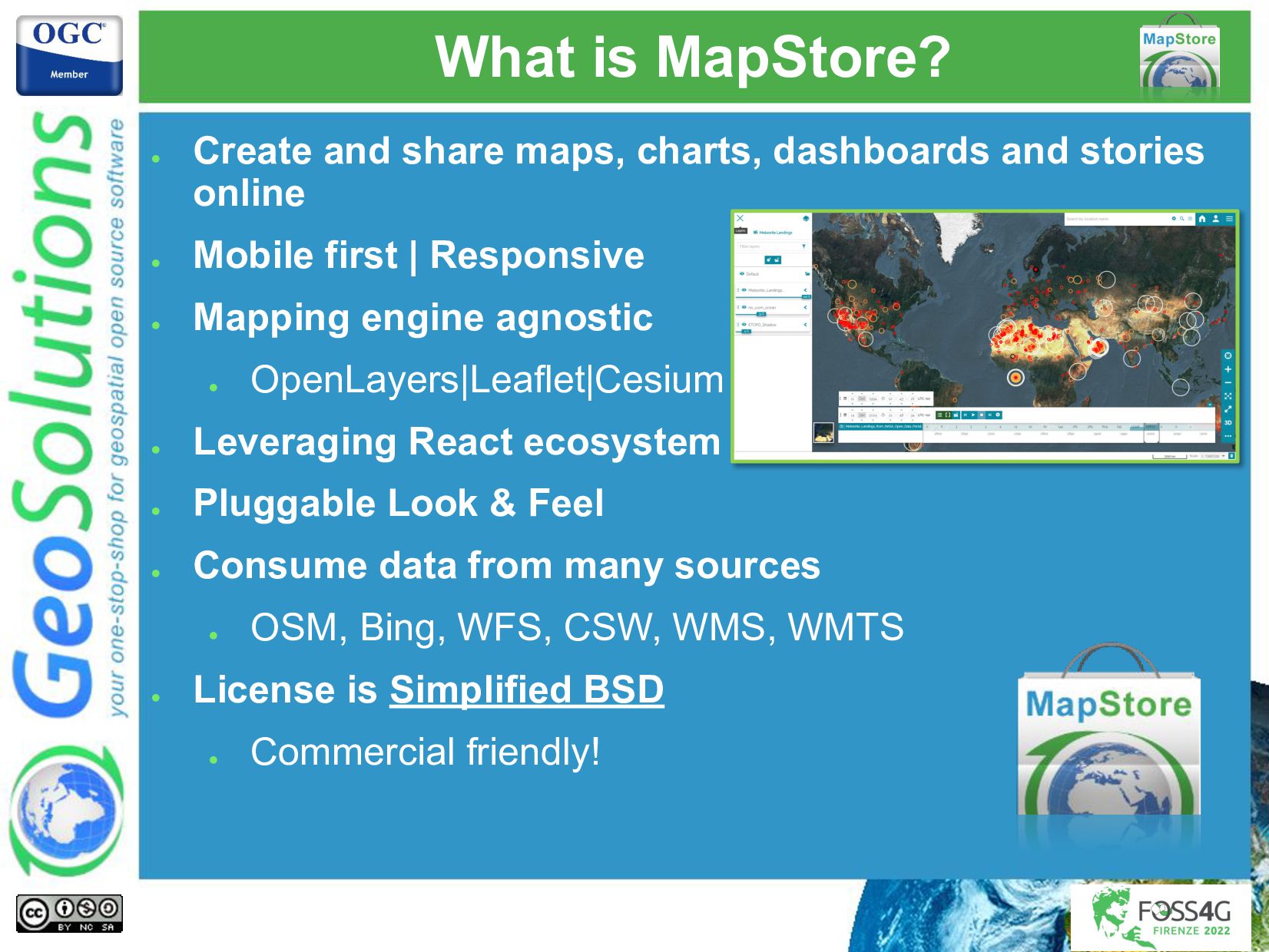
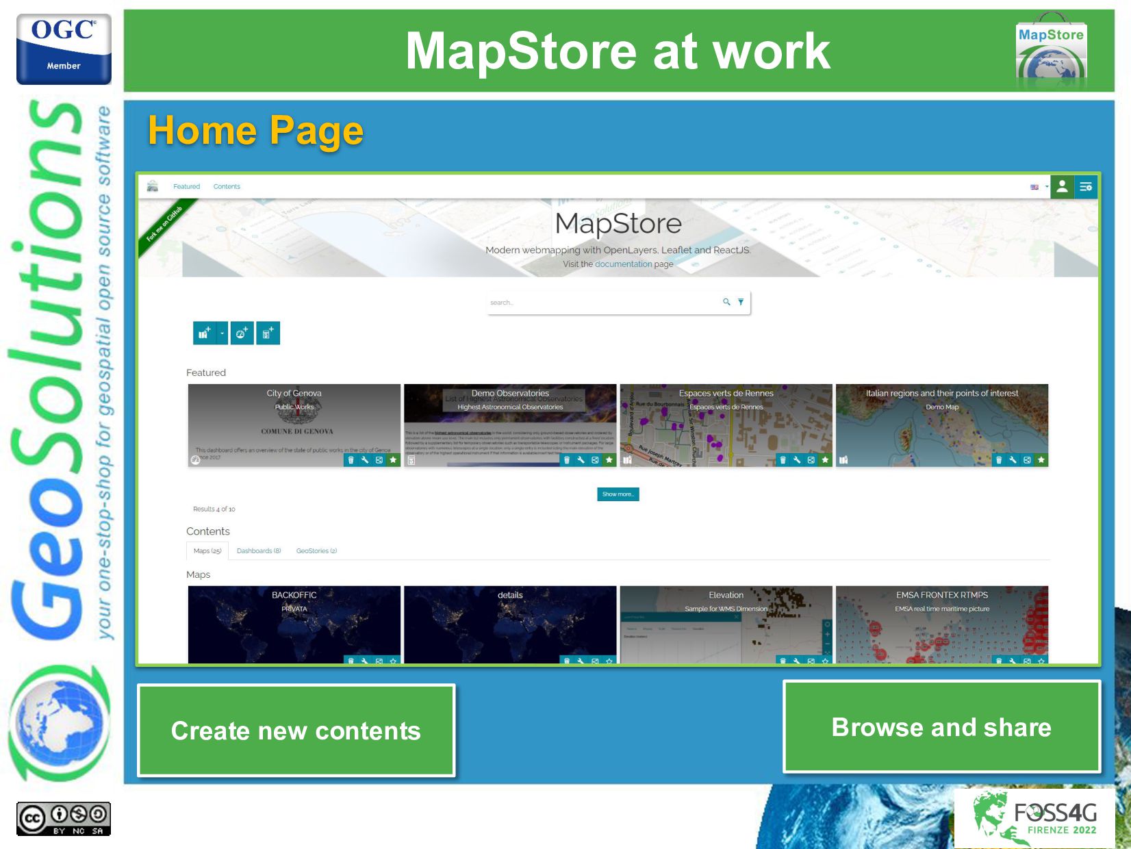
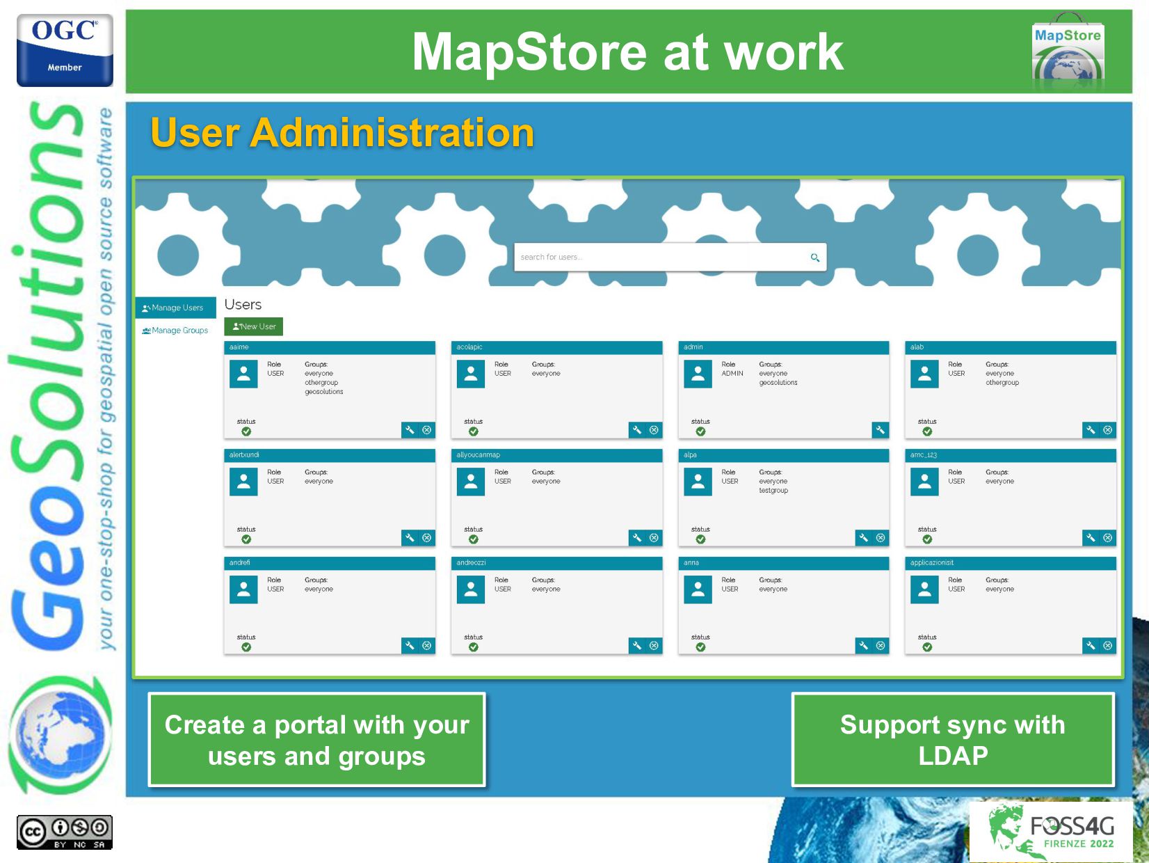
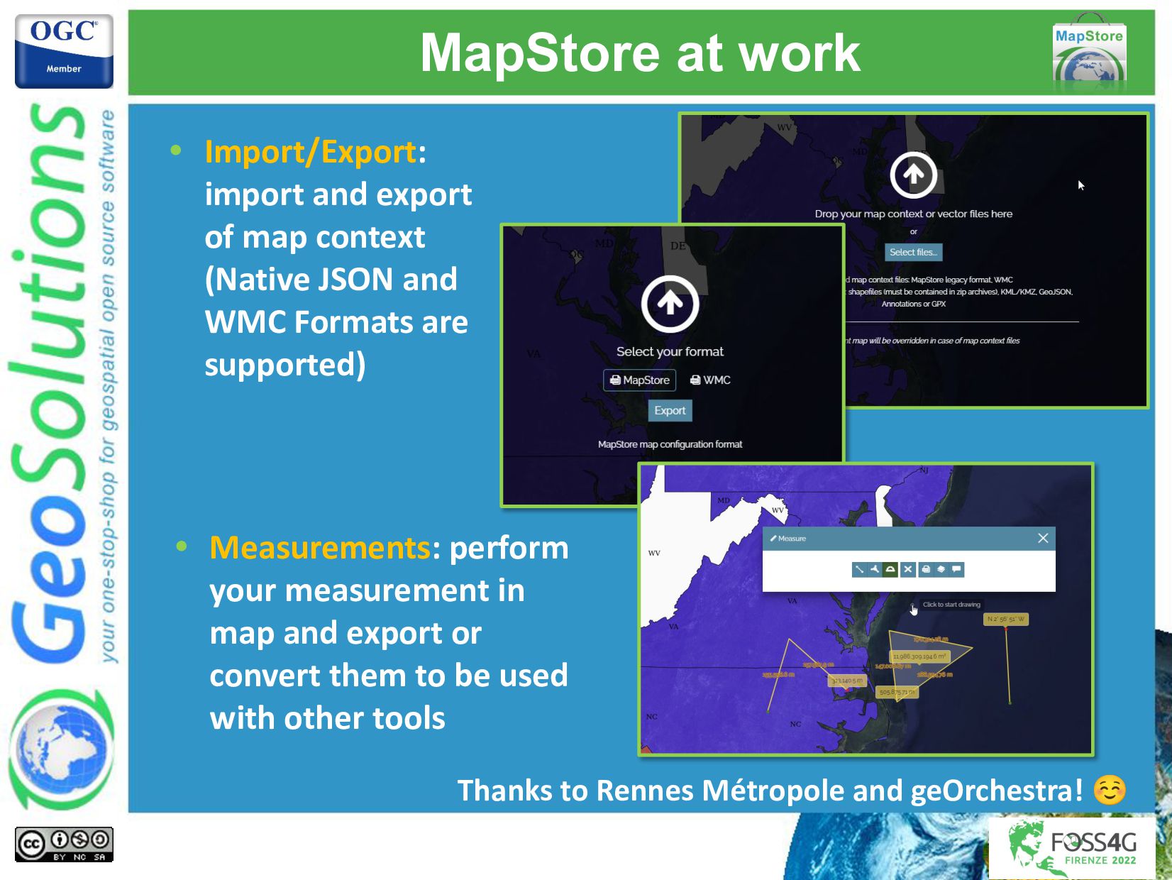
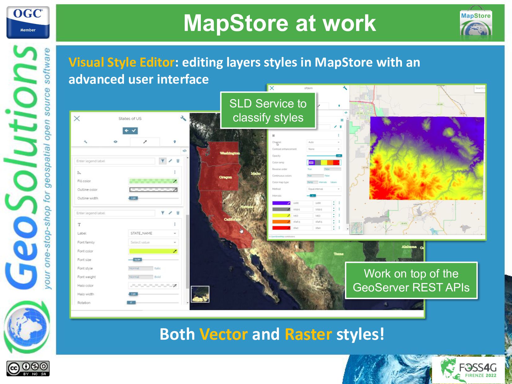
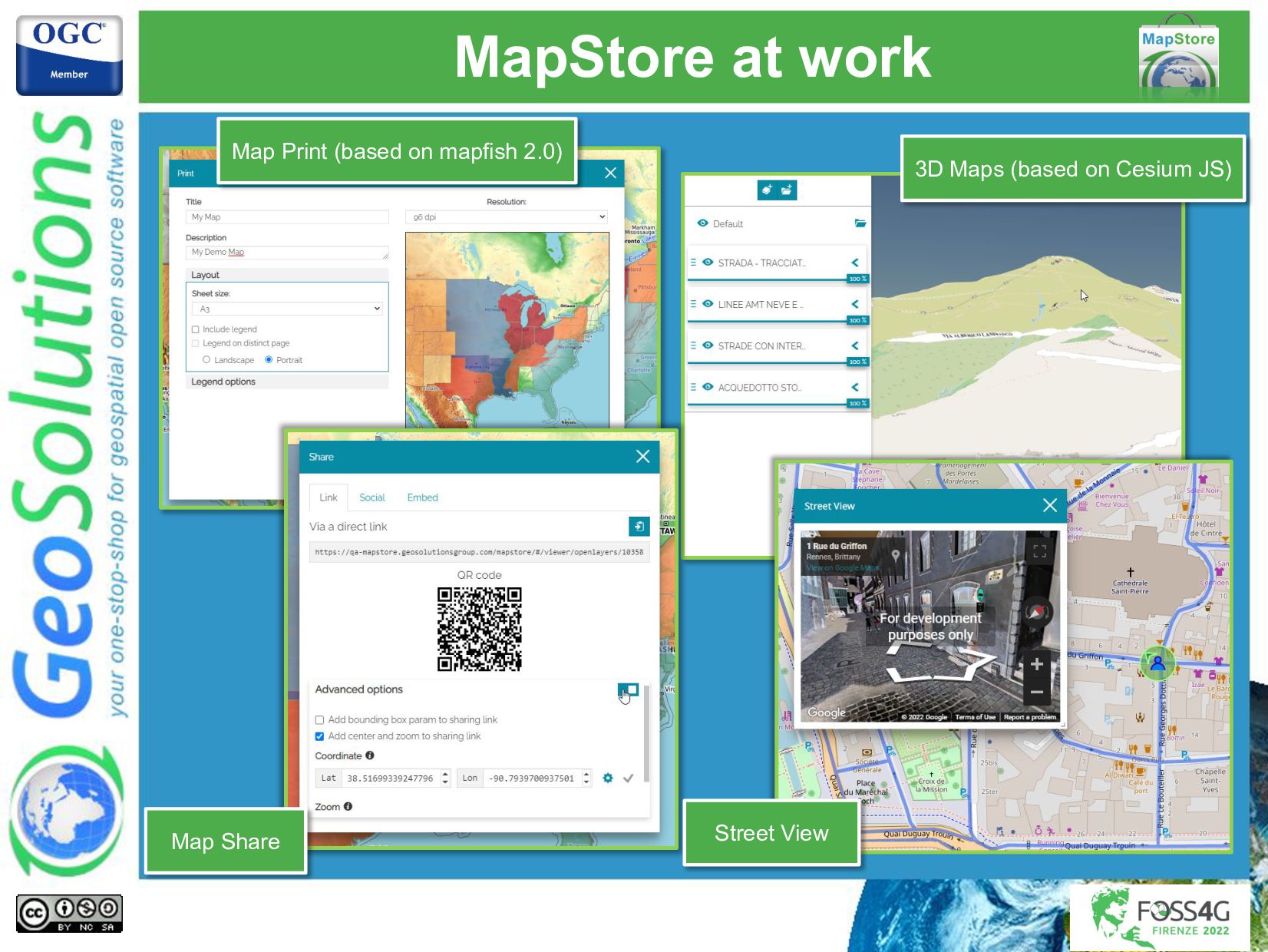
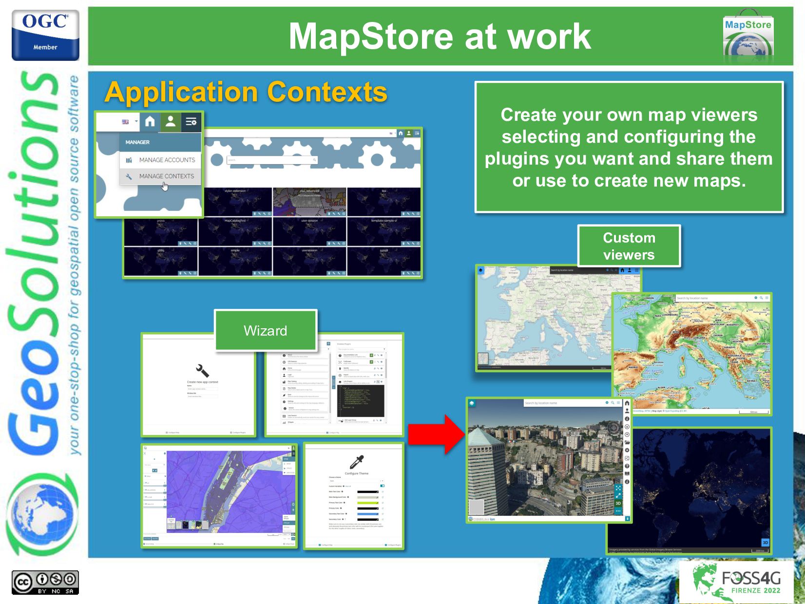
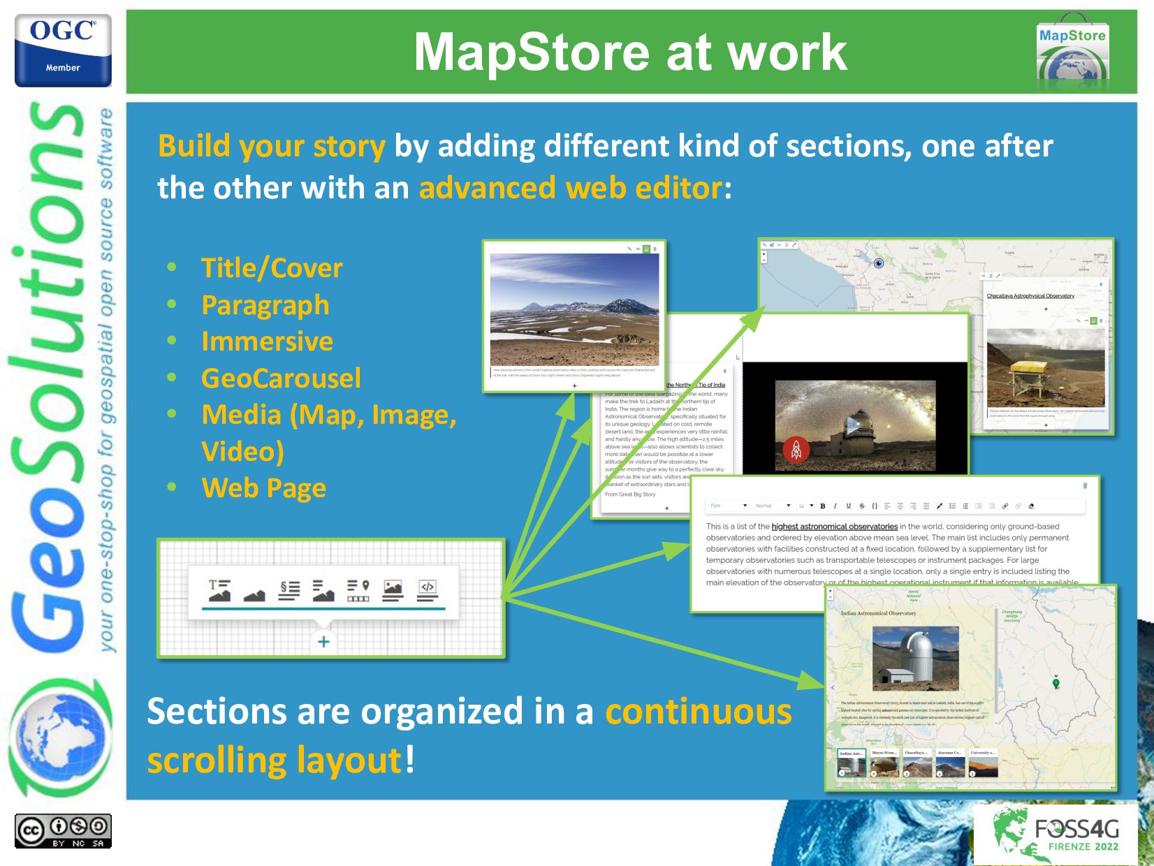
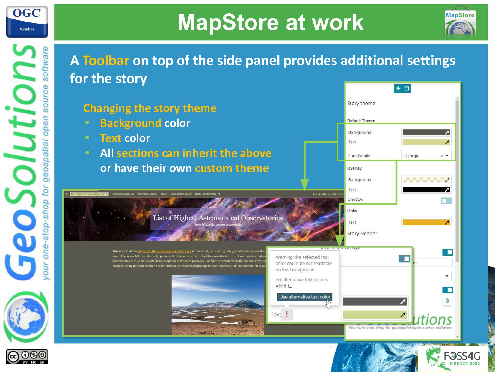
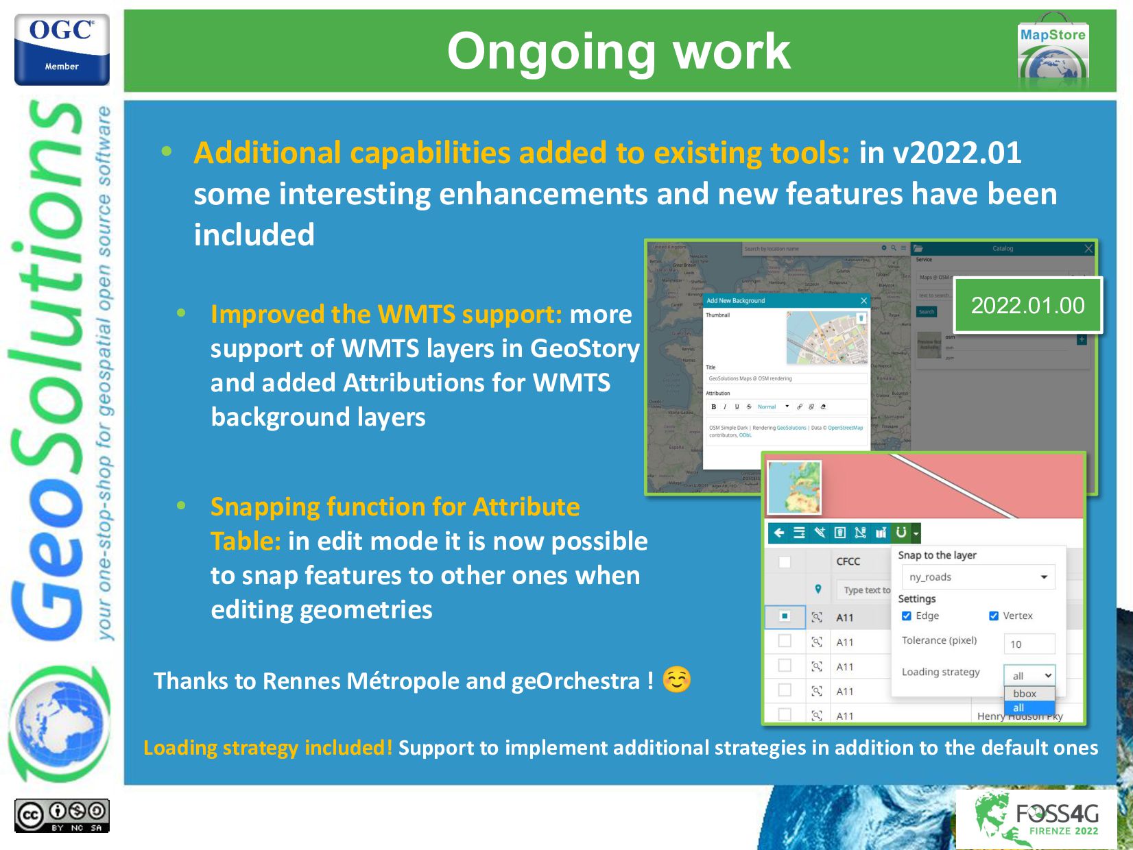
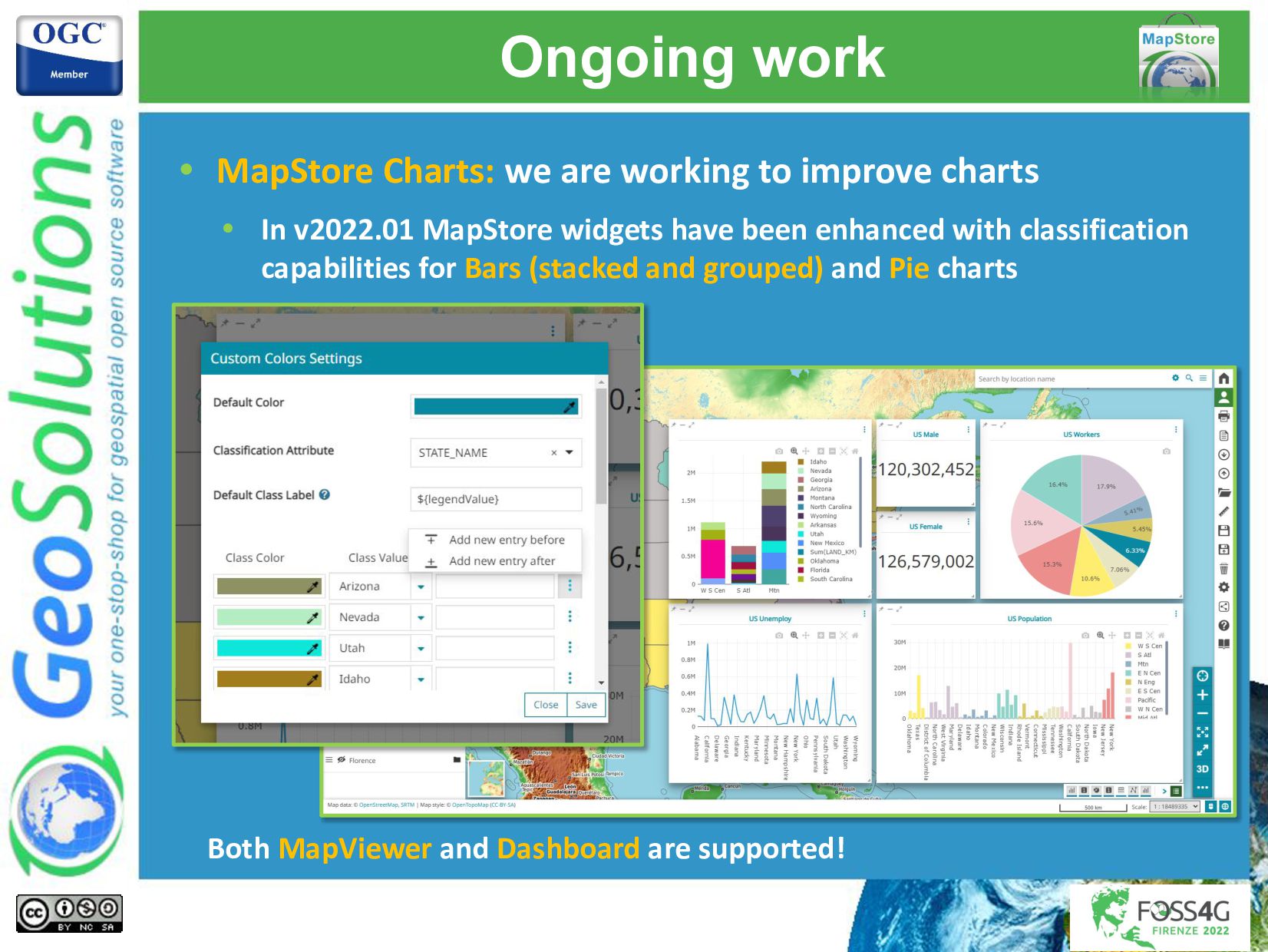
This presentation will give the audience an extensive overview of the MapStore functionalities for the creation of mapping portals, covering both previous work as well work for the future releases. Eventually, a range of MapStore case studies will be presented to demonstrate what our clients and partners are achieving with it.

Simone Giannecchini
PRO

August 31, 2022
Tweet

More Decks by Simone Giannecchini

Other Decks in Technology

Transcript

  1. Lorenzo Natali
    Tobia Di Pisa
    GeoSolutions
    MapStore,
    a year in review

    View Slide

  2. GeoSolutions

    Offices in Italy & US, Worldwide clients

    30+ collaborators, 25+ Engineers

    Our products

    Our Offer
    Enterprise
    Support Services
    Deployment
    Subscription
    Professional
    Training
    Customized
    Solutions
    GeoNode

    View Slide

  3. Affiliations
    We strongly support Open
    Source, it Is in our core
    We actively participate in
    OGC working groups and
    get funded to advance new
    open standards
    We support standards
    critical to GEOINT

    View Slide

  4. What is MapStore?

    View Slide

  5. What is MapStore?

    Create and share maps, charts, dashboards and stories
    online

    Mobile first | Responsive

    Mapping engine agnostic

    OpenLayers|Leaflet|Cesium

    Leveraging React ecosystem

    Pluggable Look & Feel

    Consume data from many sources

    OSM, Bing, WFS, CSW, WMS, WMTS

    License is Simplified BSD

    Commercial friendly!

    View Slide

  6. What is MapStore?
    It is a Product
    Use it as it is and customize the look&feel

    View Slide

  7. What is MapStore?
    It is a Framework
    You can build many different applications with
    its plugins (and by developing your own)
    covidtrackingmap

    View Slide

  8. MapStore at work

    View Slide

  9. MapStore at work
    Home Page
    Browse and share
    Create new contents

    View Slide

  10. Support sync with
    LDAP
    MapStore at work
    Create a portal with your
    users and groups
    User Administration

    View Slide

  11. Create and share contents: Maps, Application Contexts,
    Dashboards and GeoStories
    Create a new
    content
    Add data
    Set permissions
    and save
    Share
    MapStore at work

    View Slide

  12. Map Viewer
    mobile layout
    Many tools
    Time traveling
    Widgets
    annotations
    geocoder
    ...
    MapStore at work

    View Slide

  13. A lot of Plugins available in the core !!!
    MapStore at work
    ● Table of Contents
    ● Annotations
    ● Style Editor
    ● Measure
    ● Print
    ● Timeline/Playback
    ● Feature Editor
    ● Widgets
    ● Map Details
    ● Background Selector
    ● Identify
    ● Locate Me
    ● Layer Download
    ● Filter Layer
    ● Street View
    ● Catalog
    ● Map Catalog
    ● Map Import/Export
    ● Settings
    ● Mouse Position
    ● CRS Selector
    ● Swipe
    ● Search By Bookmark
    ● ScaleBox
    ● 3D Switcher
    ● FullScreen
    ● Tutorial
    ● Search Bar
    ● Save
    ● Login
    ● Share
    ● Version
    ● Burger Menu
    ● Undo/Redo
    ● Map Loading
    ● Map Templates
    ● User Session
    ● Add Group
    ● Home
    ● Zoom Buttons
    Browse and share
    All Configurable

    View Slide

  14. MapStore at work
    Attribute Table: browse features of a vector layer through a tabular
    view and access advanced utilities (Filters, Data Exports, Charts,
    Editing of features and more).

    View Slide

  15. MapStore at work
    Annotations tool: provide a great user experience in creating/drawing
    map annotations with a powerful user interface and styling capabilities.

    View Slide

  16. MapStore at work
    • Import/Export:
    import and export
    of map context
    (Native JSON and
    WMC Formats are
    supported)
    • Measurements: perform
    your measurement in
    map and export or
    convert them to be used
    with other tools
    Thanks to Rennes Métropole and geOrchestra! ☺

    View Slide

  17. MapStore at work
    Visual Style Editor: editing layers styles in MapStore with an
    advanced user interface
    SLD Service to
    classify styles
    Both Vector and Raster styles!
    Work on top of the
    GeoServer REST APIs

    View Slide

  18. MapStore at work
    Map Print (based on mapfish 2.0)
    Map Share
    3D Maps (based on Cesium JS)
    Street View

    View Slide

  19. MapStore at work
    Application Contexts
    Create your own map viewers
    selecting and configuring the
    plugins you want and share them
    or use to create new maps.
    Wizard
    Custom
    viewers

    View Slide

  20. MapStore at work
    Yes, you can do it from the User Interface! ☺
    Install extensions
    Setup base map
    Select and
    configure plugins
    Customize
    theme

    View Slide

  21. MapStore at work
    Available for standard or custom installations
    Develop and install
    your own
    Extensions

    View Slide

  22. MapStore at work
    One Installation - Many Applications !!

    View Slide

  23. MapStore Dashboard: general overview
    MapStore at work
    Chart
    Widgets
    Counter
    Widget
    Text
    Widget
    Legend
    Widget
    Widget
    menu
    Map
    Widget
    Table
    Widget
    Dashboard
    toolbar

    View Slide

  24. MapStore at work
    • Widget Editors
    Fine tuning of all widgets based
    on OGC standards

    View Slide

  25. MapStore at work
    MapStore GeoStory:
    create inspiring and immersive stories by combining text,
    interactive maps and multimedia content (e.g. images, video or
    other third party content).
    View Mode
    Edit Mode

    View Slide

  26. MapStore at work
    Build your story by adding different kind of sections, one after
    the other with an advanced web editor:
    • Title/Cover
    • Paragraph
    • Immersive
    • GeoCarousel
    • Media (Map, Image,
    Video)
    • Web Page
    Sections are organized in a continuous
    scrolling layout!

    View Slide

  27. MapStore at work
    A Toolbar on top of the side panel provides additional settings
    for the story
    Changing the story theme
    • Background color
    • Text color
    • All sections can inherit the above
    or have their own custom theme

    View Slide

  28. New Features

    View Slide

  29. Ongoing work
    • Additional capabilities added to existing tools: in v2022.01
    some interesting enhancements and new features have been
    included
    • Improved the WMTS support: more
    support of WMTS layers in GeoStory
    and added Attributions for WMTS
    background layers
    • Snapping function for Attribute
    Table: in edit mode it is now possible
    to snap features to other ones when
    editing geometries
    2022.01.00
    Thanks to Rennes Métropole and geOrchestra ! ☺
    Loading strategy included! Support to implement additional strategies in addition to the default ones

    View Slide

  30. Ongoing work
    • MapStore Charts: we are working to improve charts
    Both MapViewer and Dashboard are supported!
    • In v2022.01 MapStore widgets have been enhanced with classification
    capabilities for Bars (stacked and grouped) and Pie charts

    View Slide

  31. Ongoing work
    • Additional capabilities added to existing tools: in v2022.01
    some interesting enhancements and new features have been
    included
    • Map Viewer query parameters:
    enhanced the support to viewer
    query parameters (also via
    POST)
    • 3D query parameters:
    enhanced sharing capabilities
    for the 3D map providing the
    support for additional options
    for the camera orientation
    2022.01.02

    View Slide

  32. Ongoing work
    • 3D Tiles: we are working to improve the MapStore 3D viewer
    through the inclusion of new interesting updates:
    • Update of the Cesium JS library to the latest version. This helps to solve also
    some performance issues present in the older version
    • Support for a new catalog source
    and layer type for 3D Tiles
    • Support for 3D Tiles styling
    • More work in progress to support more
    styling capabilities
    3D Tiles Specs 1.0
    2022.01.02

    View Slide

  33. Future Work

    View Slide

  34. Ongoing work
    • Layout enhancements: in v2022.02 some interesting
    improvements will also be provided for the new MapStore
    layout where:
    • The Options menu will be replaced by a Sidebar
    • Other layout changes such as: smaller buttons
    and reduces size of side panels on the right
    2022.02.00

    View Slide

  35. Ongoing work
    • Base support for OpenID: For development of specific
    implementations: It will support login with:
    • Keycloak (with Single-Sign-On)
    • Google (login)
    2022.02.00

    View Slide

  36. Ongoing work
    • More on 3D: we are working to move further steps on the 3D
    functionalities
    • Support 3D geometries in the Cesium map (in GeoJSON format)
    • Support of WFS layers also in Cesium map
    • Styling of 3D vector features with the style editor
    2022.02.00

    View Slide

  37. Ongoing work
    • More on 3D: we are working to move further steps on the 3D
    functionalities
    • More experiments aimed to
    enrich the styling capabilities of
    3D Tiles (based on the OGC Styling
    specifications 1.0) such as: labels,
    alignment of Graphics
    (Marks/Icons) and labels, clamp
    to ground and extrusion
    properties and more
    • Some investigations to possibly
    support experimental styling
    properties
    • Some experiments aimed to
    include the selection of multiple
    Terrain layers for in the 3D map 2022.02.00

    View Slide

  38. Ongoing work
    • Downstream projects: we are
    working on a new project
    system that helps to maintain
    and update existing projects
    and new ones. We are going to
    separate gradually the core
    from the product to have the
    core library in npm package(s)
    • Reduce the loading time at
    startup by reviewing and
    reducing the bundle size
    • Optimize build time and
    resource consumption
    • Performances: MapStore is
    growing very quickly. For
    this reason, we are
    working to keep it as
    optimized as possible to:
    2022.Q4
    2022.Q3
    2022.Q4

    View Slide

  39. Who uses MapStore

    View Slide

  40. GeoNode

    View Slide

  41. Rennes Metropole -
    geOrchestra

    View Slide

  42. Who uses MapStore?
    ● Halliburton
    ● Rennes Metropole (via geOrchestra)
    ● Austrocontrol
    ● MapStand
    ● UN FAO
    ● EMSA
    ● World Bank (via GeoNode)
    ● Unesco (via GeoNode)
    ● EARTH-IArno river basin authority
    ● Region of Tuscany (Hydrologic Service)
    ● Region of Tuscany (Urbanistic Department)
    ● LaMMa
    ● City of Munich
    ● City of Florence
    ● City of Genova
    ● City of Bozen
    ● City of Brussels
    ● IGB (via GeoNode)
    This is only a
    small list

    View Slide

  43. Mapstore @ the Municipality of
    Florence

    View Slide

  44. Mapstore2 @Florence Municipality
    • The POINT OF CONTACT with Geo Data @ Florence Municipality
    • About 2.000 OGC Services available for users
    • More than 500 OGC Services for applications, internal & external
    • The GIS Self Service
    • A simple environment with which to build a analysis scenario
    • We can find on this system geographical open data (published on
    opendata.comune.fi.it)
    • An open source
    “digital twin” (with
    Cesium 3d feature)

    View Slide

  45. View Slide