Upgrade to Pro — share decks privately, control downloads, hide ads and more …

Saltwater Intrusion Paper

Sponsored · Your Podcast. Everywhere. Effortlessly. Share. Educate. Inspire. Entertain. You do you. We'll handle the rest.
Avatar for Tj Haigler Tj Haigler
April 28, 2025
7

Saltwater Intrusion Paper

Avatar for Tj Haigler

Tj Haigler

April 28, 2025
Tweet

Transcript

  1. Saltwater Intrusion Stress on coastal communities of Hilton Head Island,

    South Carolina TJ Haigler Department of Geological and Environmental Sciences, Appalachian State University, Boone, North Carolina, USA 28608 Table of Contents ABSTRACT.............................................................................................................................. 2 PLAIN LANGUAGE SUMMARY ................................................................................................. 2 I. BACKGROUND..................................................................................................................... 3 II. STUDY AREA ...................................................................................................................... 5 III. PROPOSED STUDY ............................................................................................................. 7 IIIa. Methodology ..........................................................................................................................7 IIIb. Anticipated Results and Implications ...................................................................................... 10 ACKNOWLEDGEMENTS ........................................................................................................ 11 REFERENCES ........................................................................................................................ 12 TABLES ................................................................................................................................ 14 Table 1. Chloride concentrations per water year on Hilton Head Island in relation to the drinking water standard (adapted from Falls et al., 2005). ........................................................................................................ 14 FIGURES .............................................................................................................................. 15 Figure 1. Map of Hilton Head Island and surrounding mainland. Location of current ASR well project on Hilton Head Island, South Carolina (adapted from Payne, 2010). ................................................................................ 15 Figure 2. Confining unit and reversal of groundwater gradient within the UFA (adapted from Payne, 2010). . 16 Figure 3. Breakdown of units of the Upper Floridan Aquifer (adapted from Provost et al., 2006). .................. 17 Figure 4. Chloride concentration in groundwater at Hilton Head Island (blue) in relation to drinking water chloride standard (orange) (adapted from Falls et al., 2005). ............................................................................ 18 Figure 5. Stored water volume of ASR well 1 at Royal James, Hilton Head Island (adapted from Pyne, 2015). 19
  2. ABSTRACT Hilton Head Island is a popular tourist destination and

    small barrier island off the coast of South Carolina. The barrier island is plagued by a disaster, the disaster is known as saltwater intrusion. Saltwater intrusion is at an all-time high in wells and freshwater aquifers such as the Upper Floridan Aquifer (UFA) that underlays Hilton Head Island. Over pumping approximately 20 miles away in Savannah, Georgia causes the reversal of the groundwater gradient, and in turn, saltwater intrusion. One method to reverse the effects of over pumping and alleviate some of the pressure put on coastal communities, is the introduction of more aquifer storage recovery (ASR) wells on the island. These wells will be effective to hold freshwater that was pumped out of the aquifer, even in areas that are compromised by chloride deposits from saltwater intruding on the aquifer. Creating a buffer zone around these wells will also boost the amount of water stored during recharge times such as that of a low-sea level period. By implementing more ASR wells, more groundwater will be available to use in the form of undisturbed freshwater. This will alleviate bans and restrictions put on the water usage by the people of Hilton Head Island. This will also relieve certain dependences on the UFA for industrial and commercial usage. PLAIN LANGUAGE SUMMARY Saltwater is invading on the amount of freshwater that can be used at Hilton Head Island, South Carolina. In and around the island, the freshwater systems that were once used to pump out freshwater for industrial, agricultural, and personal uses (such as drinking water) are being taken over by saltwater particles entering once closed off storage units. At the beginning, these storage units were exposed due to over-pumping of water out of wells on the island and from nearby city, Savannah, Georgia. One way to reduce the impact of saltwater intrusion on drinking
  3. water is through recovery wells. Recovery wells allow storage of

    freshwater from wells that are compromised by saltwater. This freshwater will stay stored for use during times with little water movement, such where sea level is lower, and during periods with little rainfall. This limits the number of changes that need to be made to other water collection methods, and the amount of water laws that need to be signed by the state and local government. This important issue could impact millions of people, not only at Hilton Head but in many other coastal communities. Something as simple as watching water intake would help loosen the negative effects brought upon by saltwater on these coastal populations. Keywords: saltwater intrusion, Hilton Head Island, South Carolina, chloride, seawater, Upper Floridian Aquifer, aquifer storage recovery I. BACKGROUND Groundwater is a primary source for many communities looking for freshwater to use in agriculture, industry, and for drinking water (Barlow and Reichard, 2010). Coastal communities typically rely on aquifers for groundwater (Barlow and Reichard, 2010). As shown by the United States Geological Survey in 2004, the dependency on groundwater by coastal communities is over 14.1 billion gallons used per day (Barlow and Reichard, 2010). However, increased rates of saltwater intrusion are depleting the usable groundwater confined in aquifers (Payne, 2010). A component of higher rates of saltwater intrusion is through climate change through increasing sea-level rise (Payne, 2010; Klassen and Allen, 2017). Increased precipitation and energy stored off the coast can also influence storm surge and the possibility of increased salinization due to faster leakage or increased erosion rates (Payne, 2010; Klassen and Allen, 2017). Another factor
  4. that affects salinization rates includes over pumping from wells (Krause

    and Clarke, 2001), with well-documented data coming from areas where recharge rates are lower than well extraction rates (Pyne, 2015). Protecting coastal communities from saltwater encroaching on their freshwater supply is essential based of water usage and dependency (Barlow and Reichard, 2010). Coastal communities are also under greater stress due to a population density of three times that of an inland average (Klassen and Allen, 2017). Increased population numbers leads to greater stress on a community. This can only further increase the regressing available freshwater rates. Thus, opposing the efforts of locals and environmentalists. The Upper Floridian aquifer (UFA) is a permeable, confined freshwater aquifer sitting at depths of 30-80 m that encompasses that of Hilton Head Island, South Carolina (Pyne, 2015; Krause and Clarke, 2001). Beaufort County, South Carolina has been dependent on obtaining freshwater from the UFA since the 1880s (Falls et al., 2005). Similarly, Hilton Head Island, South Carolina has been dependent on the aquifer since communities began to develop in 1956 (Pyne, 2015). In nearby industrial locations, a lack of groundwater is becoming present, thus reversing the subsurface gradient underneath Hilton Head, increasing the flow and encroachment rates of saltwater on wells on Hilton Head Island (Pyne, 2015). Numerous entities and individuals have studied these saltwater intrusions at this site including but not limited to 1) state-level and national programs such as the U.S. Geological Survey (USGS) (Payne, 2010), the Georgia Department of Natural Resources, and the Georgia Environmental Protection Division (GaEPD) (Krause and Clark, 2001), and 2) geologists and hydrologists.
  5. Studying saltwater intrusion on a broad scale can be translated

    to that of a particular area such as Hilton Head Island and vice versa. The study proposed during the later portion of this paper will stem from previous studies aimed to reverse the effects of saltwater intrusion. The timeframe considered will focus on rates of intrusion, rates of influx versus outflux, and future data determined by the effectiveness of desalinization from underground aquifers and factors contributing to rates of intrusion. II. STUDY AREA Hilton Head Island is a larger barrier island belonging to the state of South Carolina (Figure 1). The island stretches 19 km long and reaches a width of 6 km (Pyne, 2015). The depth of the Upper Floridian Aquifer (UFA) underneath the northern portion of Hilton Head Island is approximately 30 m thick and continues to deepen as you move southward (Pyne, 2015). Traditionally, the town of Hilton Head relied on three major freshwater springs located near the saltwater body of Port Royal Sound on the northern end of the island (Pyne, 2015). However, surrounding communities have had a substantial impact on the traditional workings of the UFA. Located about 30 km southwest of the island is Savannah, Georgia, a highly developed city on the coast of the state. Due to increased groundwater extraction for industrial and personal usage, the available groundwater stored in the UFA has declined. (Pyne, 2015). This reversed the flow gradient beneath Hilton Head Island, which is shown in Figure 2, and located in an area of the UFA that is only 30 m thick, increasing the likelihood of saltwater intruding in the aquifer on the northern part of the island (Pyne, 2015). In this area, the speed of saltwater movement has been calculated at around 200 feet per year (Pyne, 2015). Evaluating the results of the reversed
  6. gradient has already begun, and tracking said changes are crucial

    to providing relief to coastal communities such as Hilton Head. There are many ways that saltwater intrusion rates can be measured. The first is through examination of chloride rates in the UFA. As measured by Falls et al. (2005), the concentration of chloride reaches that of 370 milligrams per liter in the UFA, almost 15 times the amount of 25 milligrams per liter measured in the fresh groundwater collection site. An increase in these levels can be attributed to increased erosion in the area. Where erosion makes the confining unit thin, the aquifer is directly exposed to surrounding seawater. This sends the seawater towards pump locations and increases chloride concentrations on the island (Payne et al., 2001; Payne 2010). In other models on Hilton Head Island, chloride collection data is continuously increasing, beginning at less than 100 milligrams per liter, levels are now upwards of 600 milligrams per liter (Falls et al., 2005). Other tracking of saltwater intrusion has been linked to a changing climate. As simulated and modeled by Payne (2010), the increased rate of sea-level rise shifts over a larger area of land, producing a greater area that is susceptible to the downward pull of the saltwater. It is seen that northern areas surrounding Hilton Head Island are more susceptible to saltwater intrusion due to sea-level rise due to the shallow confining unit under the northern part of the island as shown in Figure 3 (Payne, 2010). Payne (2010) also describes that recharge conditions need to be monitored more closely than sea-level rise rates as a reduction of freshwater recharge directly correlates to an increased number of plumes of saltwater. Pyne (2015) studied the reversing effects of saltwater intrusions brought upon by installation of aquifer storage recovery (ASR) wells. There are many locations of ASR wells in the United States and all over the world (Pyne, 2015). The location of the newly developed ASR
  7. well on Hilton Head Island is shown in Figure 1.

    Through construction of a transmission pipeline connecting the ASR well to the mainland, it was determined that the ASR well would be able to recharge and keep pumping freshwater in the saltwater contaminated aquifer (Pyne, 2015). It was also modeled that the ASR well is more effective on the island when surrounded by a buffer zone to increase the efficiency and rate of reverse osmosis within the aquifer and pumping system (Pyne, 2015). Numerous cycles are continuing to be run and there are increasing numbers of modeling processes on Hilton Head Island to study and develop studies pertaining to increasing saltwater intrusion rates. III. PROPOSED STUDY "Current saltwater mitigation methods on Hilton Head Island include water restrictions for the general public, creation of buffer zones around wells, and implementation of aquifer storage recover (ASR) wells. I propose to supplement these mitigation methods with underground radar techniques to determine well sites, as well as tracking chloride concentrations, and adding future recovery wells around the island. I also believe that human interactions could also shift to produce a noticeable change for the environment of Hilton Head Island regarding freshwater availability. With just a few changes, such as producing more ASR wells around the island, the evaluation of saltwater intrusion rates and how to control the alteration to these coastal communities can be tracked easier. IIIa. Methodology A lot can be taken from previous studies to merge into one study that would more accurately describe the freshwater crisis on Hilton Head Island. From studies ran by Chang
  8. (2011), Payne (2010), Pyne (2015), Zuurbier (2017), monitoring chloride concentrations

    is essential to the performance for development of new well systems. The addition of more ASR well sites would be an ideal combat method for saltwater intrusions. As introduced by Pyne (2015), ASR wells store drinking water that is located in groundwater affected by saltwater. As of today, there is only one ASR well on Hilton Head Island, and it is located on the northern end of the island, as seen in Figure 1. Implementing more ASR wells on the northern end of the island, would be most beneficial. This is because it is the part of the island that is easily compromised by saltwater due to the shallow well depth availability. These wells will not only store freshwater that can be used for municipal purposes, but they can also track data that will describe more about the rate of saltwater intrusions. A main test that could be conducted to determine future rates of saltwater intrusion is to test for chloride concentration. In ASR wells, testing for chloride concentration would comprise of running test cycles that last for two months each over the course of one year. This would confirm the amount of freshwater being stored and relating it to geochemical reactions underground (Pyne, 2015). Increased chloride concentrations indicate saltwater intrusion, so monitoring chloride is essential to understanding the rate s of saltwater intrusion. The chloride concentrations on Hilton Head Island are already growing and have reached rates upwards of 1,700 mg/L in some wells on the island (Pyne 2015; Williams and Gill, 2010). The relation between chloride concentrations on Hilton Head Island and the standard amount of chloride ions present in drinking water is shown in Figure 4. From that data, which is shown in Table 1, it is determined that the water on Hilton Head Island is well past acceptable chloride concentration for commercial usage. ASR wells may help mitigate these increasing chloride concentrations, but first I need to determine where ASR wells should go. I will evaluate sea level fluxes in the areas ten miles around the island to
  9. determine aquifer depth and to eliminate saltwater probability of making

    it to well depth due to accidental drilling into shallow confining units. Chang et al. (2011) used MODFLOW computer codes and SEAWAT to study sea level rise rates on the rates of saltwater intrusion and discovered that saltwater intrusions are less likely to produce a major impact when the reversal and recovery rates of numerous wells had a longer duration to recharge, such as when sea levels are low. It would be ideal to run more MODFLOW computer data to see if sea-level rise is also correspondent to chloride concentrations. Additionally, MODFLOW data would show if there is a direct correlation between sea-level rise, chloride concentration, and saltwater intrusion rates per recharge period. I also studied implications brought upon by wells that were developed further inland from saltwater or brackish waters. This would require modeling the land using geochemical mapping to decide where the ground is deep enough to reach into the confining unit for groundwater use without penetrating shallower sections of the already compromised UFA. Then using the same structure of monitoring ASR wells and sea-level rise rates, one could test for chloride concentrations per unit of groundwater pumped out through these wells. Alternatively, a more basic approach would be to document water usage for different areas. Since over pumping from previous wells on the island as well as over pumping from nearby Savannah, Georgia has reversed the water gradient under Hilton Head Island, pumping rates could be reduced at twenty wells within twenty miles from Hilton Head (Krause and Clarke, 2001; Pyne, 2015). The reversal of the groundwater gradient is shown in Figure 2. This could be implemented in several ways: mapping out specific companies that overuse water for industrial purposes, setting water regulations on and around the island, or collecting data straight from the individuals as a source.
  10. IIIb. Anticipated Results and Implications To observe the effect of

    adding additional ASR wells, a protection area should be added around the newly developed wells. Adding this buffer should be able to be seen on SEAWAT mapping devices as something that increases ASR performance and maximum storage time (Zuurbier and Stuyfzand, 2017). By adding this buffer, there is less of a chance of disrupting the recovery cycle by other industrial and human practices and the efficiency and amount of water stored in ASR wells should increase. As seen in Figure 5, the previous ASR well on Hilton Head Island is performing to proposed standard and has risen to meet the initial goal of the operation. This not only is promising for the continuation of the wells storage capacity to increase as buffers are added to relay recovery times, but also shows that we can expect more ASR wells to be able to efficiently run on Hilton Head Island. If more wells are added to the island, and all wells perform and continue to hold their maximum capacity of freshwater, then the people of Hilton Head may be able to 1) always have freshwater available if over pumping is eliminated and 2) allow government officials to decrease water limitations for industrial, agricultural, and personal usage. Moving wells further inland should not only limit the amount of saltwater that is able to get into the island’s freshwater but will also be able to provide details on how fast the UFA is getting compromised by saltwater. Knowing this will allow us to know depths of the confining unit and total aquifer depth of the UFA as well as total percentage still available for recovery processes. If this rate is growing too fast, such as the chloride concentration rates, then saltwater will have a higher chance of being present in freshwater confining units and aquifers and decrease the probability of ASR function.
  11. Furthermore, identifying the main areas and sources of over pumping

    may be able to provide a little diminish on saltwater intrusion rates. Although this is not a major factor today (as they were in creating the original problem), investing in even more regulatory laws would overall positively effect usage out of ASR wells as well as decrease dependency in the human population on and nearby the island. ACKNOWLEDGEMENTS I would like to extend my gratitude to the numerous individuals who provided context, support, and feedback along the writing stages of this paper. Thank you, Dr. Evans (Appalachian State University), for providing the necessary guidelines and extensive feedback. Thank you to Abby Kopp, Megan Balkus, and Joe Brogdon (Appalachian State University) for also providing insightful feedback to better this scientific study. It is also important to recognize and thank the previous researchers who provided direct evidence for this paper in the form of previous studies and tests run. Without any of these individuals, this paper would not be what it is. To them I extend thanks.
  12. REFERENCES Barlow, P. M., & Reichard, E. G. (2010). Saltwater

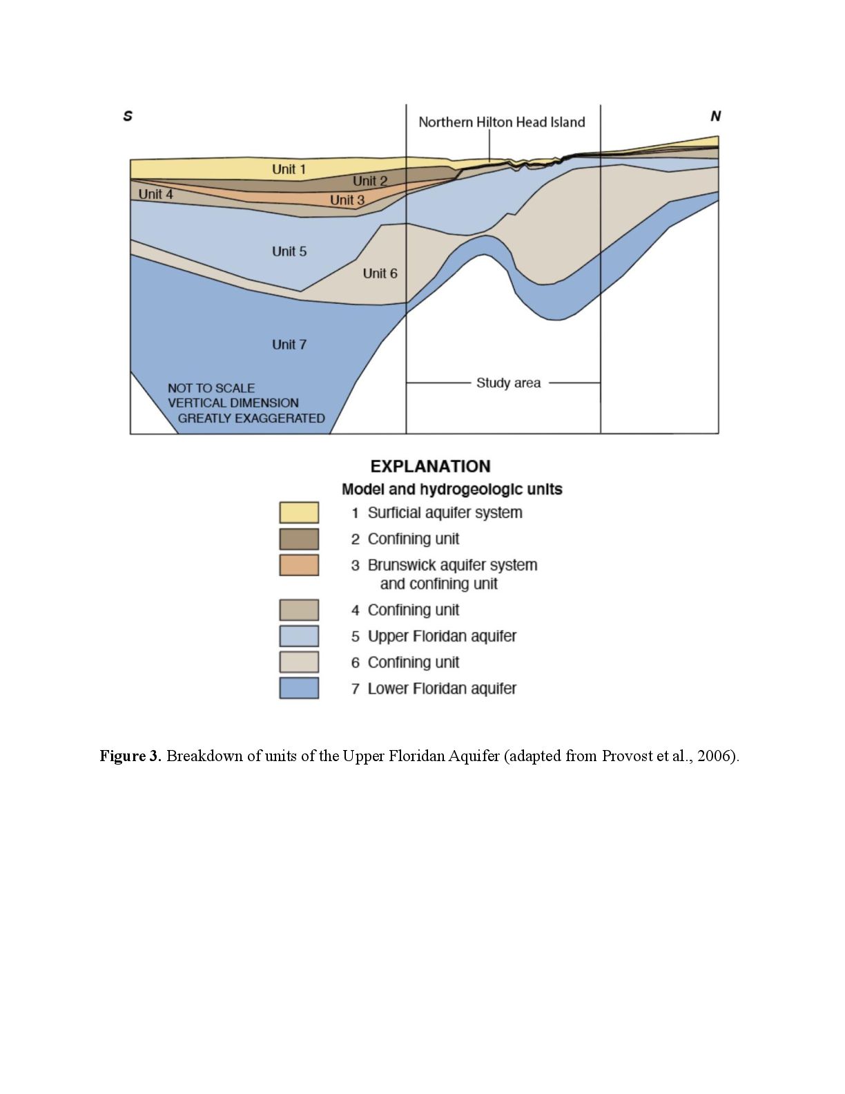
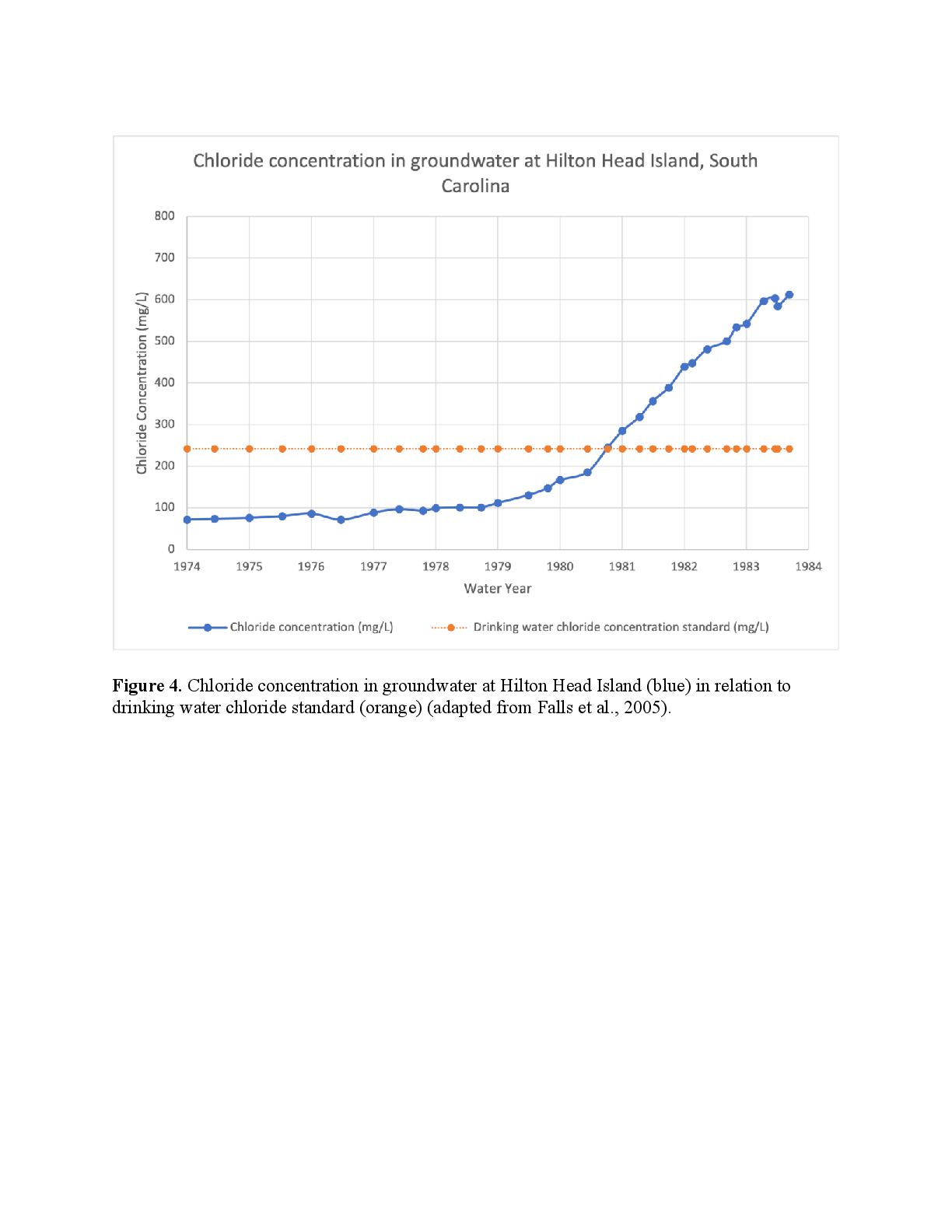
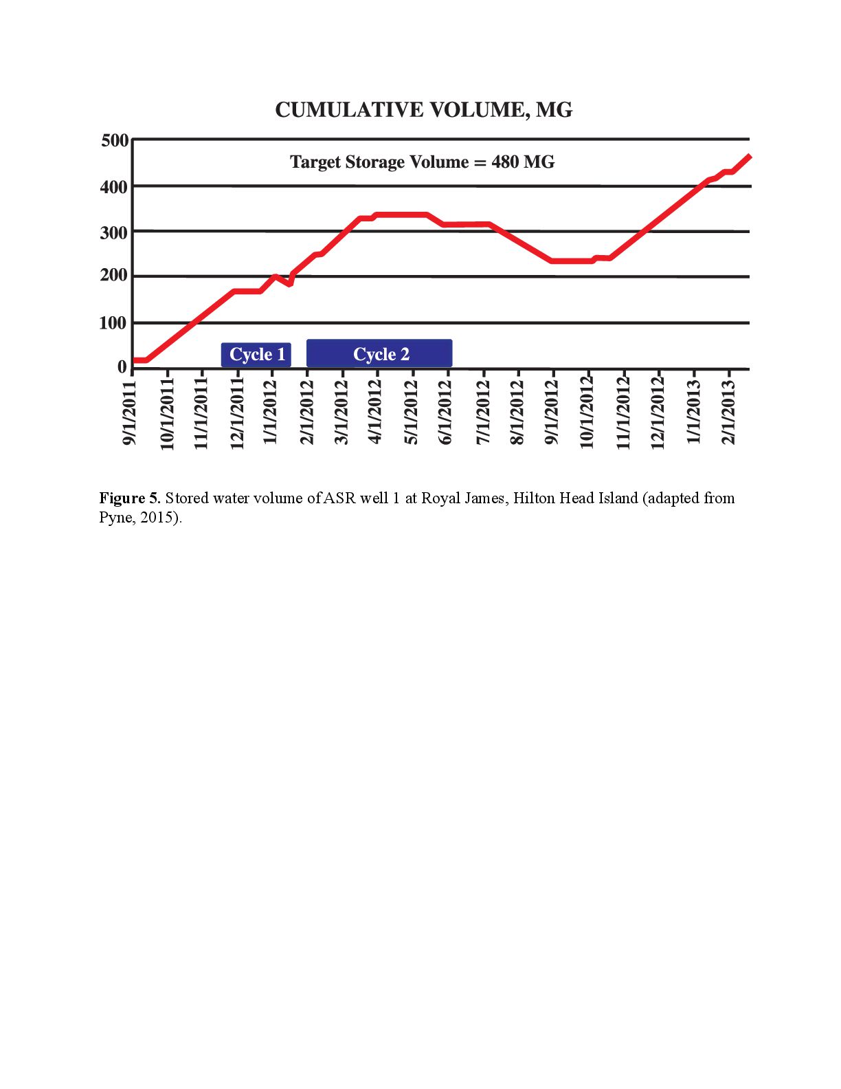
    intrusion in coastal regions of North America. Hydrogeology Journal, 18(1), 247. Chang, S. W., Clement, T. P., Simpson, M. J., & Lee, K. K. (2011). Does sea-level rise have an impact on saltwater intrusion?. Advances in water resources, 34(10), 1283-1291. Falls, W., Ransom, C., Landmeyer, J. E., Reuber, E. J., & Edwards, L. E. (2005). Hydrogeology, water quality, and saltwater intrusion in the upper Floridan aquifer in the offshore area near Hilton Head Island, South Carolina, and Tybee Island, Georgia, 1999-2002. U. S. Geological Survey. Klassen, J., & Allen, D. M. (2017). Assessing the risk of saltwater intrusion in coastal aquifers. Journal of Hydrology, 551, 730-745. Krause, R. E., & Clarke, J. S. (2001). Coastal ground water at risk—saltwater contamination at Brunswick, Georgia and Hilton Head island, South Carolina (No. 2001-4107). US Geological Survey. Payne, D. F. (2010). Effects of climate change on saltwater intrusion at Hilton Head Island, SC, USA. In SWIM21—21st saltwater intrusion meeting, Azores, Portugal (pp. 293-296). U. S. Geological Survey. Payne, D. F., Provost, A. M., & Voss, C. I. (2001). Preliminary numerical models of saltwater transport in coastal Georgia and Southeastern South Carolina. Georgia Institute of Technology. 2001 Georgia Water Resources Conference. Provost, A. M., Payne, D. F., & Voss, C. I. (2006). Simulation of saltwater movement in the Upper Floridan aquifer in the Savannah, Georgia-Hilton Head Island, South Carolina,
  13. area, predevelopment-2004, and projected movement for 2000 pumping conditions (No.

    2006-5058). US Geological Survey. Pyne, R. D. G. (2015). Aquifer storage recovery: An ASR solution to saltwater intrusion at Hilton Head Island, South Carolina, USA. Environmental Earth Sciences, 73(12), 7851-7859. Williams, L. J., & Gill, H. E. (2010). Revised hydrogeologic framework of the Floridan aquifer system in the northern coastal area of Georgia and adjacent parts of South Carolina. U. S. Geological Survey. Zuurbier, K. G., & Stuyfzand, P. J. (2017). Consequences and mitigation of saltwater intrusion induced by short-circuiting during aquifer storage and recovery in a coastal subsurface. Hydrology and Earth System Sciences, 21(2), 1173-1188.
  14. TABLES Table 1. Chloride concentrations per water year on Hilton

    Head Island in relation to the drinking water standard (adapted from Falls et al., 2005).
  15. FIGURES Figure 1. Map of Hilton Head Island and surrounding

    mainland. Location of current ASR well project on Hilton Head Island, South Carolina (adapted from Payne, 2010).
  16. Figure 3. Breakdown of units of the Upper Floridan Aquifer

    (adapted from Provost et al., 2006).
  17. Figure 4. Chloride concentration in groundwater at Hilton Head Island

    (blue) in relation to drinking water chloride standard (orange) (adapted from Falls et al., 2005).
  18. Figure 5. Stored water volume of ASR well 1 at

    Royal James, Hilton Head Island (adapted from Pyne, 2015).