Upgrade to Pro — share decks privately, control downloads, hide ads and more …

Free Webinar: GeoNode 5.0 Release

Sponsored · Your Podcast. Everywhere. Effortlessly. Share. Educate. Inspire. Entertain. You do you. We'll handle the rest.
Avatar for Simone Giannecchini Simone Giannecchini PRO
February 26, 2026
1

Free Webinar: GeoNode 5.0 Release

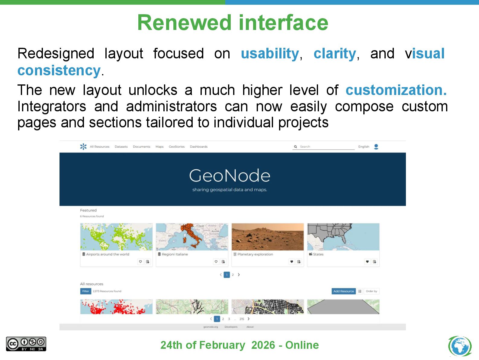
This webinar provides a focused overview of GeoNode 5, highlighting the main functional and architectural changes introduced in the new release. We will cover the redesigned user interface, the new metadata engine, improvements to data lifecycle management, and key operational updates, with a brief look at what these changes mean for users and integrators.

Avatar for Simone Giannecchini

Simone Giannecchini PRO

February 26, 2026
Tweet

More Decks by Simone Giannecchini

Transcript

  1. Geospatial open-source experts • Building open-source geospatial products since 2006

    • Certified ISO 9001, ISO 27001 • Delivering scalable, secure, and interoperable solutions for public and private sectors • Products • Services < Enterprise Support Services Enterprise Subscriptions Professional Training Customized Solutions 24th of February 2026 - Online
  2. helping customers all over the world 24th of February 2026

    - Online 335 customers, 42 countries, 4 continents
  3. to transform geospatial data into insights 24th of February 2026

    - Online We design, develop and deploy end-to-end scalable, interoperable, secure geospatial solutions collect ingest analyze decide
  4. thanks to a top-notch team 24th of February 2026 -

    Online • Offices in Italy & US, Global Team • 40+ Staff Members • 30+ Software Engineers • GeoServer Committers & Steering Members • GeoNode Committers & Steering Members • MapStore Committers & Steering Members • GeoNetwork Committers & Steering Members We do not just use the products; we actively participate and lead the development!
  5. What is GeoNode GeoNode is an open-source platform designed for

    the management and publication of geospatial data and the development of Spatial Data Infrastructures (SDI) and Geospatial Information Systems (GIS). It allows inexperienced users to upload, edit, analyze and expose their GIS data 24th of February 2026 - Online
  6. What is GeoNode Dataset Spatial files like: Raster (GeoTiff) or

    Vector (gpkg, shp, geojson, kml, kmz, csv, 3d Tiles) Documents Anything without a spatial reference like document, images, video. More than 50+ extensions are supported! Maps Agglomerate of multiple dataset in one place, perfect to see multiple layer in a single place GeoStories The powerpoint of GeoNode, present your data in a simple and interactive way Dashboards The analytic part of GeoNode, analyze and filter your data 24th of February 2026 - Online
  7. When should i use GeoNode? GeoNode in action! 1. Data

    Management and Cataloging • Metadata Management: You need tools to create, manage, and update comprehensive metadata for all your datasets to ensure they are properly documented and discoverable. • Data Organization and Security: You need to organize your data into layers and maps and control access and permissions (who can view, download, edit, or manage the data). 2. Data Publication and Sharing • Dissemination to the Public: You want to make your spatial data easily discoverable and accessible to a wide audience, including non-GIS specialists and the general public. • Catalog Service: You want to use GeoNode as a centralized catalog service for data that might be distributed across different remote services, providing a single point of discovery. 3. Visualization and Mapping • Interactive Web Maps: You need a platform that allows users (even those with little GIS experience) to quickly create, view, and share interactive web maps by combining different layers and background maps. • Rapid Mapping: You want the ability to go from raw geospatial data to a finished map visualization with custom styles quickly and without extensive development. • GeoStories and Dashboards: You want to create engaging, narrative-driven map presentations (GeoStories) or map-based dashboards to communicate compelling stories or findings. 24th of February 2026 - Online
  8. Renewed interface Redesigned layout focused on usability, clarity, and visual

    consistency. The new layout unlocks a much higher level of customization. Integrators and administrators can now easily compose custom pages and sections tailored to individual projects 24th of February 2026 - Online
  9. New generation metadata engine Before: Metadata schemas and validation rules

    were hard-coded or tied to internal models, making changes difficult 24th of February 2026 - Online
  10. New generation metadata engine Now: Fully defined through JSON Schema,

    making the system cleaner, more modular, and far easier to extend 24th of February 2026 - Online
  11. Robust dataset lifecycle: replace, update The platform reintroduces the ability

    to replace existing datasets with newer versions, for both vector and raster data, simplifying updates while keeping the catalog clean and consistent. 24th of February 2026 - Online
  12. Stronger data quality through validation and constraints Thanks to new

    capabilities introduced in GeoServer 2.27.3, GeoNode 5 now supports field-level constraints for vector datasets, such as numeric ranges or predefined lists of allowed values. 24th of February 2026 - Online
  13. Stronger data quality through validation and constraints It also possible

    to define this constraints in a JSON-schema payload 24th of February 2026 - Online
  14. A more flexible and controlled permission system • GeoNode 5

    introduces a new dynamic, rule-based permission system that makes access control far more flexible than before. • Permissions can now be defined using almost any criterion, including contextual or temporal conditions, and can be extended through custom rules. 24th of February 2026 - Online
  15. Richer content access and export options To make data sharing

    easier, GeoNode 5 introduces two new download formats: Excel and CSV. These widely used formats simplify integration with external tools, reporting workflows, and data analysis environments. 24th of February 2026 - Online
  16. Asynchronous engine powered by Redis • GeoNode 5 also modernizes

    how background tasks are executed. • Redis is now the core component for Celery’s message handling and result backend, replacing RabbitMQ and the previous database-based task tracking. 24th of February 2026 - Online
  17. A faster and more observable harvesting system • The harvesting

    subsystem has received several backend improvements in GeoNode 5, making it faster, more robust, and easier to operate. • Dynamic expiration of asynchronous tasks allows harvesting jobs to adapt to workload and execution context, reducing premature failures when dealing with slow or large remote services. • A new monitoring layer provides clearer visibility into each step of the harvesting pipeline, improving troubleshooting and observability. 24th of February 2026 - Online
  18. What’s new in MapStore in GN5 • Alignment of the

    homepage style and components 24th of February 2026 - Online
  19. What’s new in MapStore in GN5 • Itinerary plugin: Introduces

    the ability to calculate and visualize a route (itinerary) between two or more points on the map, typically using an external routing service. 24th of February 2026 - Online
  20. What’s new in MapStore in GN5 • Isochrone plugin: Adds

    a new tool that allows users to draw a reachability area (isochrone) around a selected point, based on time or distance parameters. 24th of February 2026 - Online
  21. What’s new in MapStore in GN5 • Imagery layers overlay

    on 3D Tiles: allows to render layers such as WMS on top of 3D Tiles, it needs to be enabled inside the 3D Tiles layer settings 24th of February 2026 - Online
  22. What’s new in MapStore in GN5 • Interactive and dynamic

    legend: allow users to filter data by clicking legend items while automatically syncing displayed categories with the current map view 24th of February 2026 - Online
  23. What’s new in MapStore in GN5 • Terrain layer selector:

    Allows users to select terrain layers in 3D visualizations from UI, enhancing control over elevation and landscape detail. 24th of February 2026 - Online
  24. What’s next • Multilingual metadata ◦ Future releases will bring

    multilingual support for metadata values, labels, and search, allowing titles, abstracts, and all metadata fields. • Non-spatial tabular datasets ◦ GeoNode will support purely tabular, non-spatial datasets, enabling advanced interactions across dashboards, charts, tables, and maps, including dynamic filtering and on-the-fly joins between spatial and non-spatial data. • Geolocated Documents ◦ Documents will be geolocated on maps using their bounding boxes, with rich media previews shown in map-click results. Images with EXIF geotags will be automatically geolocated, further blurring the line between geospatial and multimedia content. 24th of February 2026 - Online
  25. What’s next • Printing – A thoroughly assessment has been

    started to review and extend the printing service beyond the current capabilities. Dynamic templating, template composition, printing of dashboards and geostories is in the roadmap. A crowdfunding campaign has been started to sponsor its development. • Scalability – HA, Fault tolerance and horizontal scaling are key aspects in many scenarios where GeoNode is being employed. Enhanced support for Kubernetes deployments, and clustered services capabilities, are important topics for the upcoming versions of GeoNode, that are under development and testing for real case adoption. 24th of February 2026 - Online
  26. GeoNode PSC • Project Steering Committee – The GeoNode Project

    Steering Committee governs the GeoNode project by voting on project policies. The PSC is made up of individuals who are intended to represent the various communities which have a stake in GeoNode. • Upcoming actions – 2026 will see the renewal of the PSC, with the election of new members that will represent the current community and stakeholders. The process has started in January and will continue the next weeks, with the involvement of the community through the GeoNode mailing-lists. After the establishment of the new PSC, regular meetings will be held to start a fruitful discussion on the future steps for the management of the project and its relationship with the OsGeo organization. 24th of February 2026 - Online
  27. Consider contributing to the project Online version: - Stable: https://stable.demo.geonode.org/#/

    - Development: https://development.demo.geonode.org/ Repository: https://github.com/GeoNode/geonode/ Official Doc: https://docs.geonode.org/en/5.0.x/ 24th of February 2026 - Online