Upgrade to Pro — share decks privately, control downloads, hide ads and more …

GeoNode in Action, Delivering Real-World Impact...

GeoNode in Action, Delivering Real-World Impact Through Unique Land Use’s Geospatial Solutions

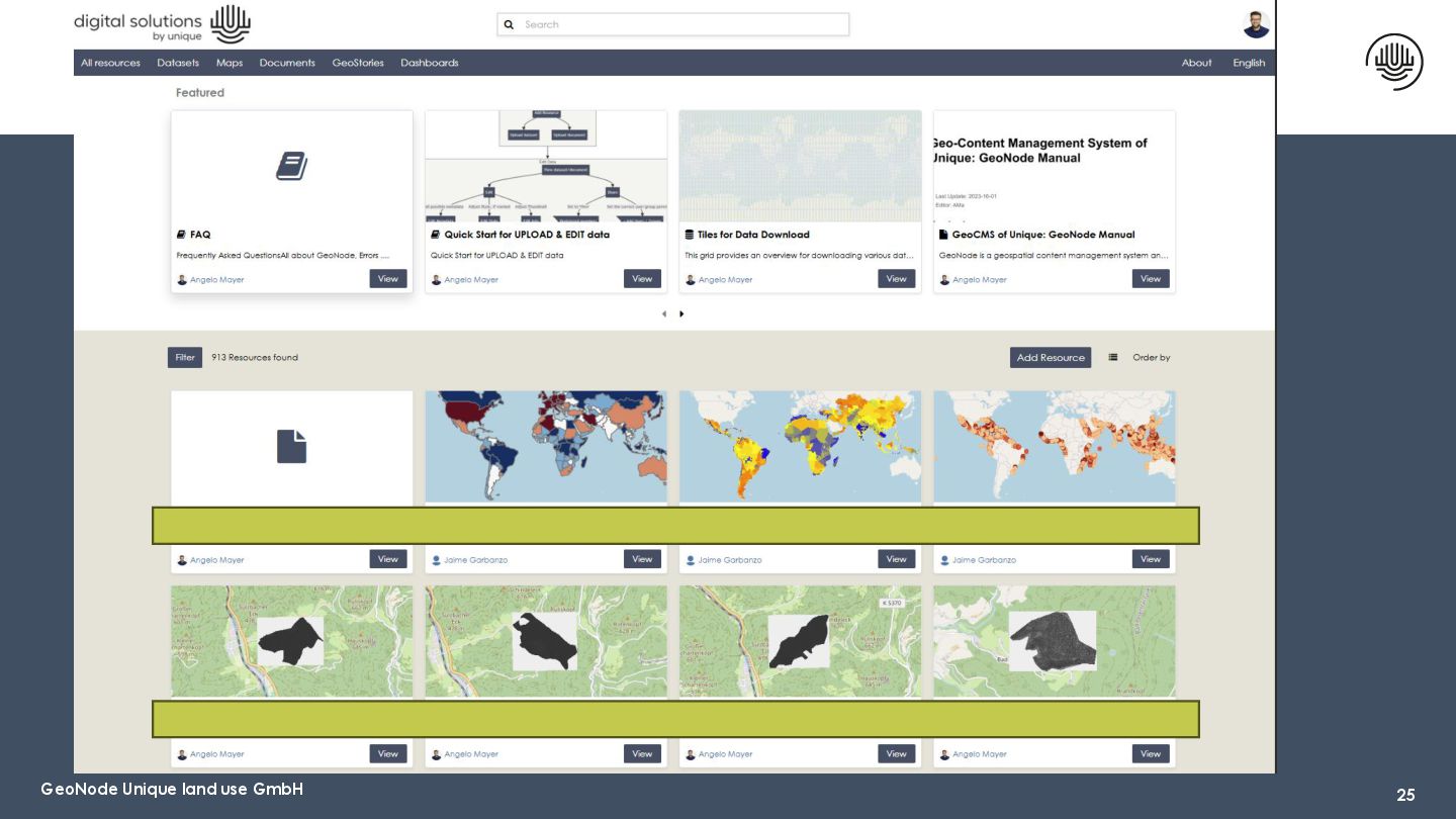
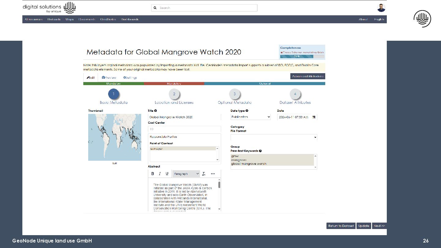
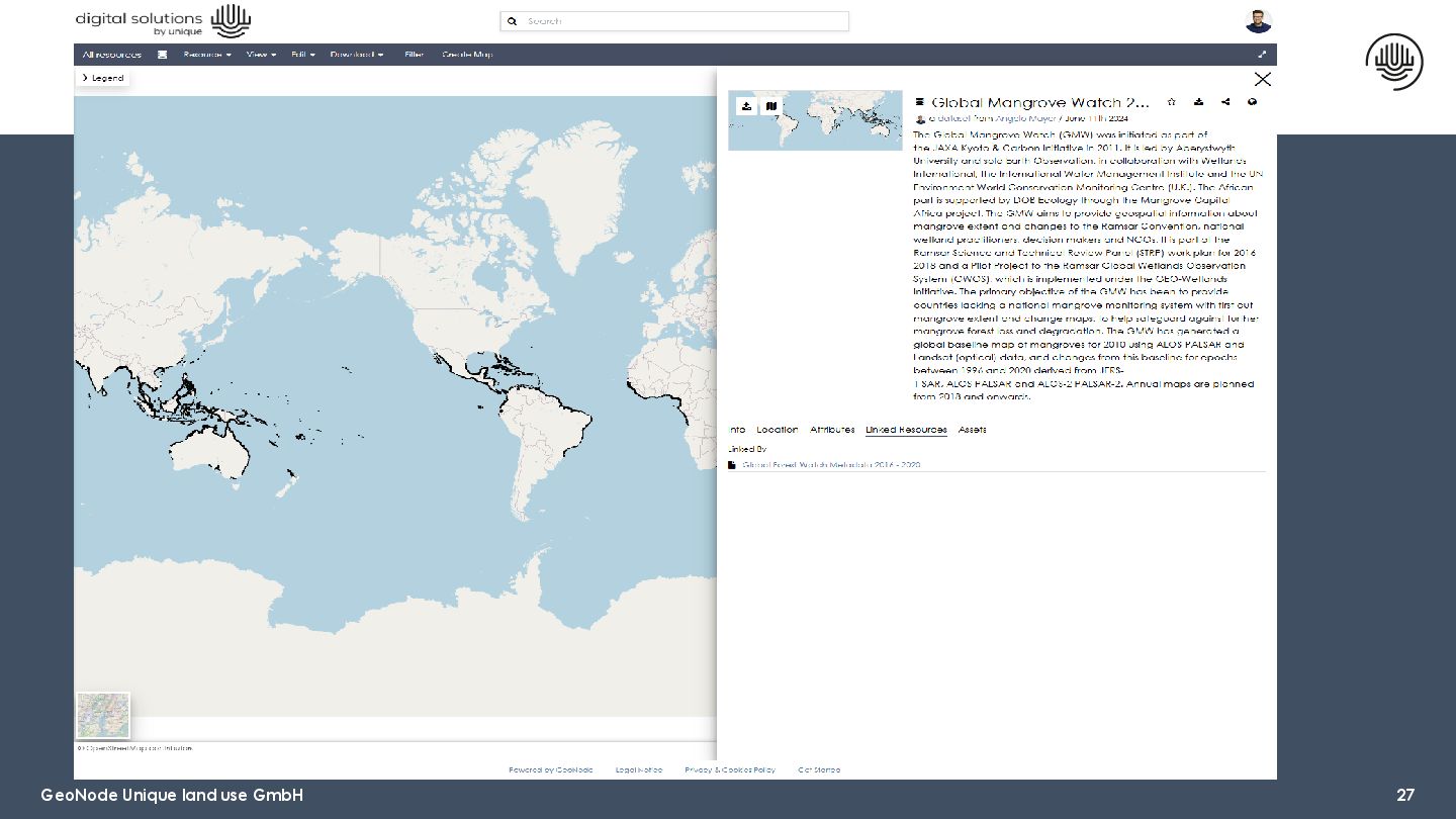
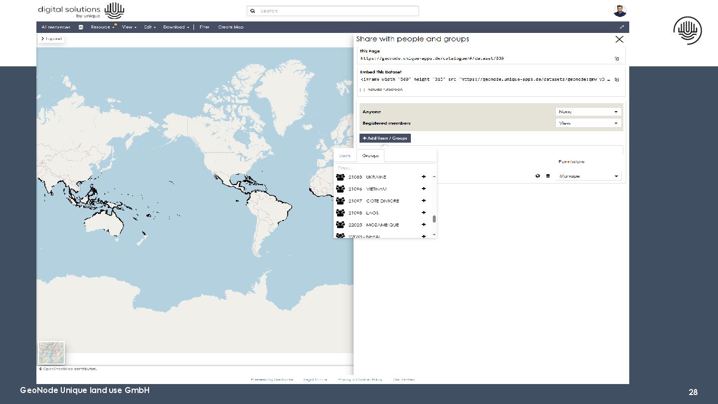
Discover how Unique Land Use GmbH leverages GeoNode to support global forestry, climate, and rural development projects. From carbon monitoring to spatial risk mapping, see how GeoNode enables efficient, secure, and collaborative geospatial data management. This session is ideal for anyone managing environmental data or building internal data portals.

Avatar for Simone Giannecchini

Simone Giannecchini PRO

August 26, 2025
Tweet

Video

More Decks by Simone Giannecchini

Other Decks in Technology

Transcript

  1. GeoNode in Action, Delivering Real-World Impact Through Unique Land Use’s

    Geospatial Solutions Freiburg, August 2025 Katja Weyhermüller Angelo Mayer
  2. 01 Introduction of Unique 02 Introduction of Digital Solutions Department

    (DSD) 03 Highlighted Projects 04 GeoNode in Practice 05 Q&A Content
  3. 01 Introduction of Unique 02 Introduction of Digital Solutions Department

    (DSD) 03 Highlighted Projects 04 GeoNode in Practice 05 Q&A Content
  4. ▪ Unique is a consulting firm specializing in development and

    implementation of intelligent land use strategies. ▪ We partner with organizations, governments, and communities to create impactful, data-driven strategies for environmental and social outcomes. ▪ Our mission: Transforming land use towards an inclusive and sustainable future for all ▪ 4 technical departments ▪ Digital Solutions ▪ Agriculture and Rural Development ▪ Forestry ▪ Climate Introduction of Unique
  5. 5 unique land use GmbH - some facts >1,000 Consulting

    assignments in over 70 countries 20,000 Hectare FSC-certified forests More than 80 in-house experts > 600 satisfied customers
  6. 6 unique land use GmbH - active worldwide Project Countries

    Offices Sister companies in Paraguay and Vietnam Experts based in Ethiopia, Uganda, Kenya, India, Argentina, Colombia , Kyrgyz Republic, Spain, Belgium, Denmark, and the United Kingdom
  7. 7 unique land use GmbH - Our customers 7 Institutions

    for development financing Governments and development organizations Private sector & non-profit organizations
  8. 01 Introduction of Unique 02 Introduction of Digital Solutions Department

    (DSD) 03 Highlighted Projects 04 GeoNode in Practice 05 Q&A Content
  9. Digital Detect Service - unique land use GmbH 9 ▪

    DSD is Unique’s specialist department for designing and delivering digital tools for sustainability. ▪ Our core areas: ▪ Data analytics ▪ Geospatial solutions including Remote Sensing ▪ Digital monitoring and reporting systems (MIS) ▪ Two teams: MIS (Monitoring and Information System) and GS (Geospatial)
  10. 11 MIS for Climate, Forestry, ARD External Data SMS &

    App-based Reporting Systems Web-Dashboard Server for database • Previous data • management systems • GIS data • International databases • Excel-Sheets SDGs Livestock Living Income Surveys Forest inventories Forest Managem ent SALM ARR CCB REDD ARD Forestry Climate
  11. Our digital services for smallholder carbon projects (ARR) Digitizing farming

    and forestry 12 no. of projects since 2013 thousand of smallholders 5,000 to 100,0000 1 6 5 2 15 1
  12. Project design • Feasibility/Eligibility assessment • Similarity measurement • Improved

    forest management • Forest inventory analysis Monitoring & reporting & verification • Deforestation & Degradation analysis • Damage detection • Land cover change detection • Statistical analysis • Methane emissions from Paddy fields • Soil erosion Carbon stocks & biomass • Forest biomass from LIDAR • Forest biomass inventory • Deforestation risk analysis Geospatial tools (processing & visualization) • GeoNode • LizMap (Interactive) 13 Geospatial Solutions (GS) Project design Monitoring, Reporting & Verification Carbon stocks & biomass Geospatial tools 54th meeting of the Expert Working Group, at GAF AG, Munich
  13. 01 Introduction of Unique 02 Introduction of Digital Solutions Department

    (DSD) 03 Highlighted Projects 04 GeoNode in Practice 05 Q&A Content
  14. 15 a. Forest Carbon Baseline Assessment Objective: Establish carbon stocks

    in restoration sites. DSD Role: Remote sensing data analysis, carbon modeling, digital reporting dashboard. b. Eligibility Assessments Objective: Assess project sites or proposals to determine eligibility for climate finance or carbon project registration. DSD Role: Develop and implement digital tools for collecting, validating, and analyzing eligibility data (e.g., remote sensing suitability, land tenure, baseline land use). c. Individual Tree Segmentation and Species Classification Objective: Precisely identify, segment, and classify individual trees from remote sensing imagery and LiDAR data. DSD Role: Applied advanced geospatial analysis and machine learning algorithms to segment tree crowns and automatically classify species. d. Forest Risk Assessments Objective: Identify and map forest deforestation risk zones. DSD Role: Geospatial risk mapping using remote sensing data and machine learning.
  15. 16 Eligibility/Feasibility Assessment: Market Standard vs Premium Process include: 1.

    Wetlands, Peatlands and Organic Soils 2. Ecoregions and/or Forest Cover 3. Deforestation 10 years prior 4. DSMW – soil vector 5. Biomass change (Loss of Removal)
  16. 17 Deforestation Risk Mapping Purpose: Highlight statistical clusters of forest

    loss across regions Timeframe: 10 days for Risk Assessment + 5 days (GEE app) Platform: GEE App
  17. 18 LiDAR Insights Purpose: Design and establishment of mixed terrestrial

    and LiDAR-based forest inventory to improve annual forest assessments. Timeframe: 10+ days based on AOI (1 vs multiple) and point cloud + RGB/Multispec dependent, reference data Segmentation Pipeline • Segments the LiDAR point cloud into single trees • Extracts Canopy Height Model and Digital Terrain Model • Extracts tree tops and other forest metrics • Single tree segmentation Classification Pipeline Random Forest Classification, trained with reference data, RGB images + LiDAR metrics to classify tree crowns identified by the Segmentation Pipeline
  18. Lidar based inventory in Paraguay Project background • Design and

    establishment of a mixed terrestrial and lidar-based forest inventory in forest managed by Unique in Paraguay to enhance the efficiency and precision of this annual forest assessments. • This approach aims to advance conventional forest inventory methods by integrating high-resolution spatial data, thereby improving forest management strategies and bolstering conservation Unique's contribution • Permanent terrestrial sample plots are used as reference data (allometric functions) • UAV based LIDAR & RGB data capturing • Single tree segmentation in Eucalyptus plantation stands • Derivation of stand attributes like height, DBH, crown size, crown cover, number of trees, volume, biomass or carbon Project region Paraguay Customer Unique wood Paraguay Department Forestry GS & DSD GS
  19. Digital Detect - MLR - Satellite-based bark beetle monitoring -

    Phase 1 Project background • Forests in Germany are under severe threat from bark beetles as a result of storms, extreme drought and high heat. As an alternative to terrestrial control surveys, which are expensive, time consuming and sometimes too late in detection, Unique was commissioned by the Ministry of Forestry of Baden- Württemberg (MLR) to develop a new method for an infestation detection in cooperation with the FVA Freiburg, having as a target to detect early stages of infestation. Using daily available satellite imagery, infested spots were mapped in a 7-14/10-days cycle. • Unique's contribution • Development of a satellite image-based detection of vitality changes in coniferous forests • Automatization of the processing chain • Provision of bark beetle “warning maps” to forest owners at regular intervals across a full summer • Verification of the detection on the ground by guided searches as ground truthing • Test of an operational infestation detection system in cooperation with forest engineers Project region Germany Customer Ministry of Forestry of Baden-Württemberg Department Forestry GS & DSD GS
  20. 21 AI Degradation Mapping • Assess whether forest management interventions

    have successfully reduced degradation rates on the coffee plots managed by partnering farmers. • Evaluate forest degradation trends • Quantify biomass changes across AOI and estimate CO2 emissions
  21. Project background 1. Joint initiative "Space in Support of International

    Development Assistance" (ESA, WB and ADB) 2. Range of application examples for Earth Observation in agricultural investment projects Unique's contribution 1. Reduction of methane emissions from rice in Indonesia • EO-based analysis of different rice cultivation methods and their GHG emissions (methane) • Identification and scaling of GHG-reducing cultivation methods 2. Appreciation of ecosystem services and protection against climate change and biodiversity loss with the help of EO project in Guyana: • Sustainable Agriculture and Forestry Policy Assessment • Classification of areas usable for agriculture under EUDR Earth Observation Information Product Development for the Agricultural Sector Project region Worldwide Customer ESA
  22. 23 Verified Carbon Standard Certification Project Show case for a

    biomass inventory following VERRA standards Project region Zambia Customer Personal Investor Department Forestry GS & DSD GS
  23. 01 Introduction of Unique 02 Introduction of Digital Solutions Department

    (DSD) 03 Highlighted Projects 04 GeoNode in Practice 05 Q&A Content
  24. Footer 29 GeoNode – Summary Strengths • Allows uploading of

    many data formats • Data and Metadata Management • User & Project Management based on permissions and customized metadata fields • Linking datasets/documents • Search filters • Enables collaboration and knowledge sharing on geospatial data • Providing through different sections (Maps, GeoStories, Dashboards etc.) multiple ways to access, share and make data actionable. • QGIS Plugin is available Possible Improvements • Possibility of integration for point cloud formats (.las, .laz) • Strengthen the QGIS plugin and expand its functionality, which would make data faster and easier to edit. • Reintroduce refresh button for datasets/documents (to be included in one of the next versions)