Upgrade to Pro — share decks privately, control downloads, hide ads and more …

How I Found My Place in the Universe (and helped everybody else find theirs)

How I Found My Place in the Universe (and helped everybody else find theirs)

My life in world coordinate space

Jessica Mink

May 06, 2015
Tweet

Other Decks in Research

Transcript

  1. How I Found My Place in the Universe (and helped

    everybody else find theirs) By Jessica Mink Smithsonian Astrophysical Observatory Harvard Smithsonian Center for Astrophysics, May 6, 2015
  2. Outline Planet Surfaces: 1973-4 Mars Observations Stars and Planets: 1976-1990

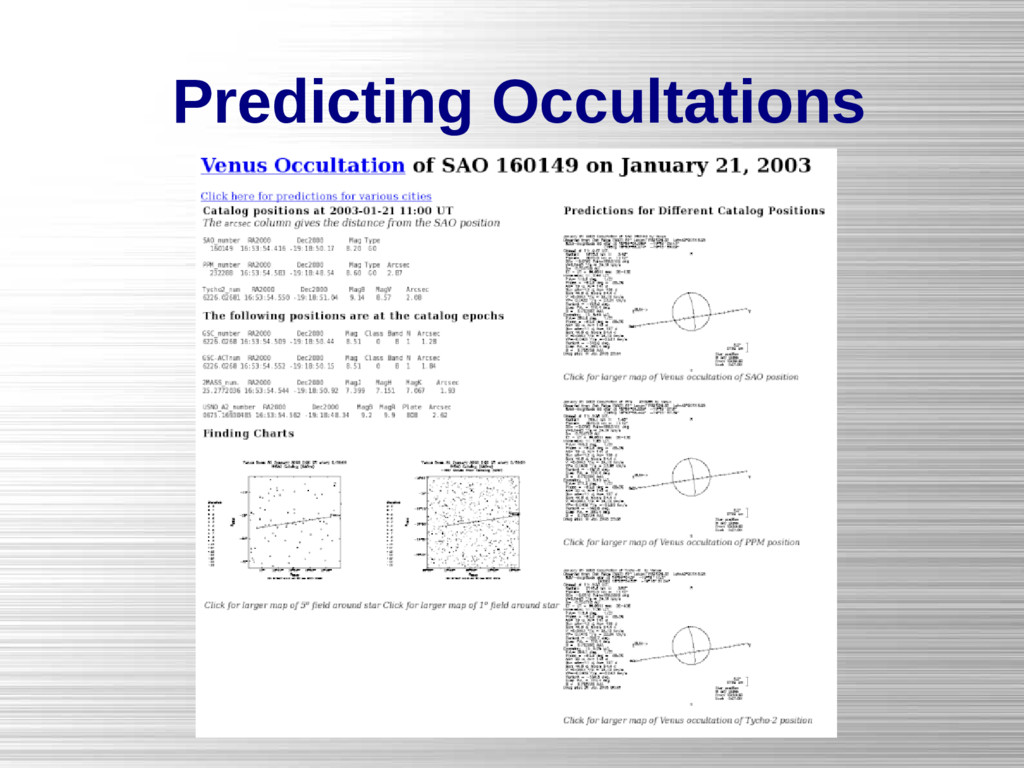
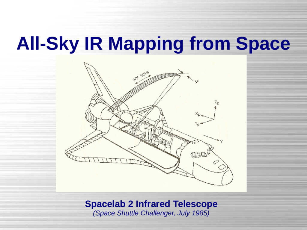
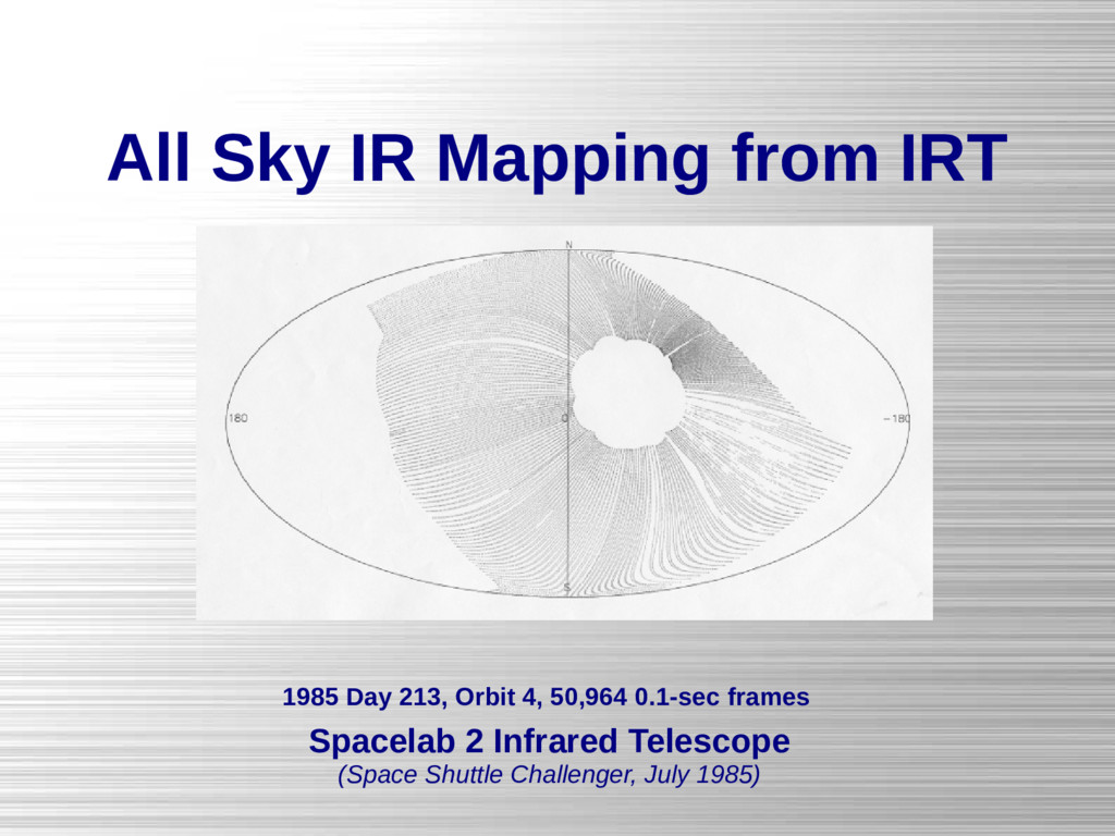
    Occultations Milky Way: 1985-1990 IRAS and Spacelab 2 IRT The Universe: 1990-2015 WCS, Plates, and Spectroscopy American Museum of Natural History, April 13, 2015
  3. It All Started With Mars MIT Vidicon Spectrometer with camera

    monitoring slit in mirror Spectrometer slit reprojected across Mercator projection of Mars surface (Mink, MIT S.M. Thesis 1974)
  4. It All Started With Mars Aperture photos projected on observed

    planet disk and reprojected onto Mercator projection of Mars (Mccord, Huguenin, Mink, and Pieters, Icarus 31, 1977)
  5. Mars Photometry Projections Orthographic: Face-on planet in sky Mercator: Map

    of entire planet surface Sky Plane Planetocentric: Predictions
  6. Then Came Uranus Occultation of SAO 158687 by Uranus and

    Its Rings (Eliot, Dunham, and Mink, Nature 261, 328, May 26 1977)
  7. Finding Stars to be Occulted Map showing appulse of the

    Pluto/Charon system to a star Note rotation of Charon around Pluto and variations in star position
  8. Predicting Occultations Palomar Sky Survey overlay for stars occulted by

    Uranus Sky plane map of Uranus ring occultation of KMU102
  9. Occultation Projections Mercator: Observability maps of earth's surface Linear: Sky

    maps with stars and planets Sky Plane: Planetocentric Occultation Predictions
  10. All Sky IR Mapping from Space IRAS 120 µm Aitoff

    All-Sky Projection 1984 Data Release HCON 1
  11. IRAS Projections (used with IRT, too) Polar: Maps of sky

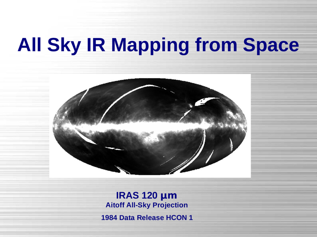
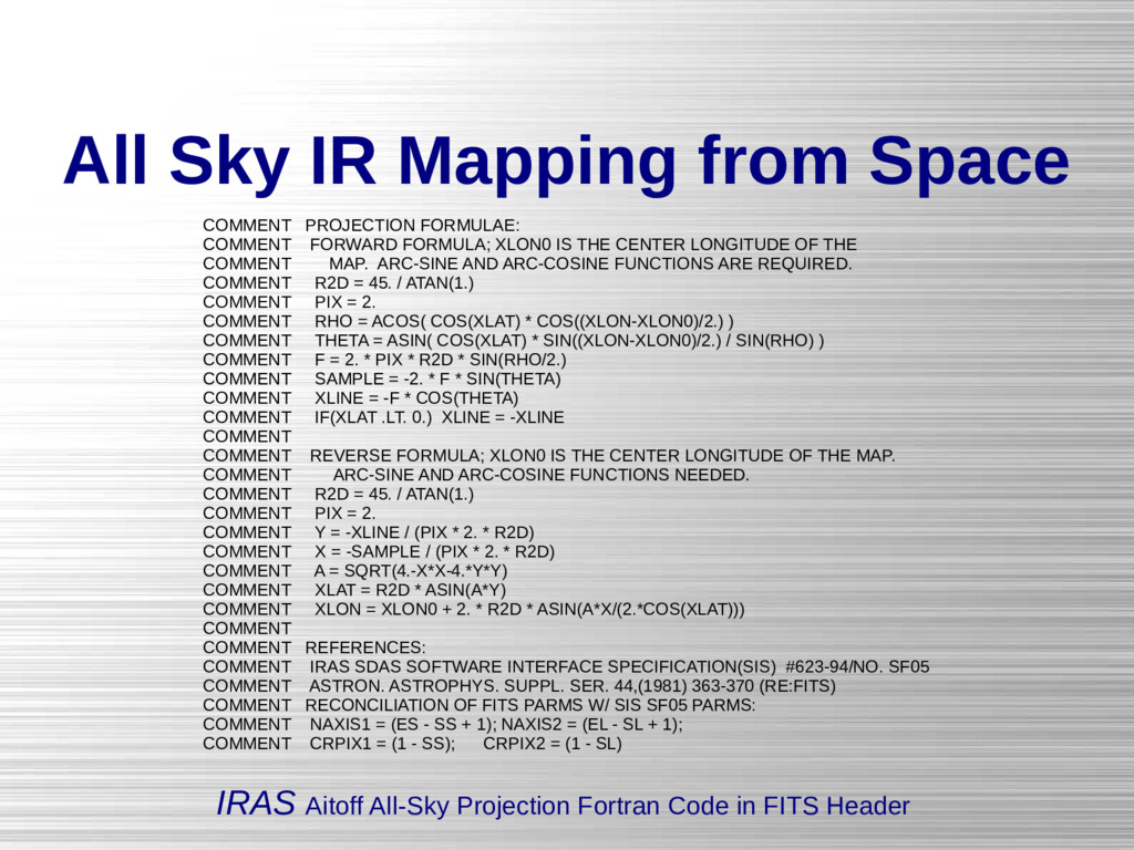
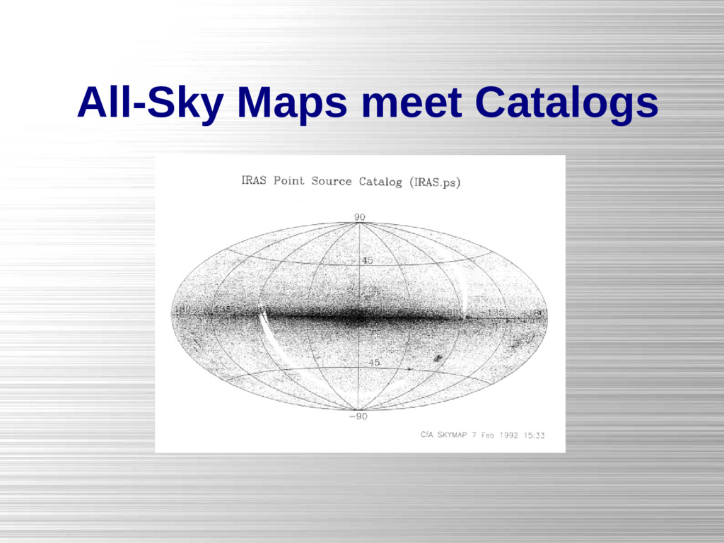
    around North and South Poles Aitoff: Map of entire sky Sinusoidal: Maps of galactic plane Gnomonic: Maps of regions of sky Infrared Astronomical Satellite (IRAS) Explanatory Supplement (1988) Edited by C.A. Beichman, G. Neugebauer, H.J. Habing, P.E. Clegg, T.J. Chester X. The Formats of the IRAS Catalogs and Atlases, D. Extended Emission
  12. All Sky IR Mapping from Space IRAS Aitoff All-Sky Projection

    Fortran Code in FITS Header COMMENT PROJECTION FORMULAE: COMMENT FORWARD FORMULA; XLON0 IS THE CENTER LONGITUDE OF THE COMMENT MAP. ARC-SINE AND ARC-COSINE FUNCTIONS ARE REQUIRED. COMMENT R2D = 45. / ATAN(1.) COMMENT PIX = 2. COMMENT RHO = ACOS( COS(XLAT) * COS((XLON-XLON0)/2.) ) COMMENT THETA = ASIN( COS(XLAT) * SIN((XLON-XLON0)/2.) / SIN(RHO) ) COMMENT F = 2. * PIX * R2D * SIN(RHO/2.) COMMENT SAMPLE = -2. * F * SIN(THETA) COMMENT XLINE = -F * COS(THETA) COMMENT IF(XLAT .LT. 0.) XLINE = -XLINE COMMENT COMMENT REVERSE FORMULA; XLON0 IS THE CENTER LONGITUDE OF THE MAP. COMMENT ARC-SINE AND ARC-COSINE FUNCTIONS NEEDED. COMMENT R2D = 45. / ATAN(1.) COMMENT PIX = 2. COMMENT Y = -XLINE / (PIX * 2. * R2D) COMMENT X = -SAMPLE / (PIX * 2. * R2D) COMMENT A = SQRT(4.-X*X-4.*Y*Y) COMMENT XLAT = R2D * ASIN(A*Y) COMMENT XLON = XLON0 + 2. * R2D * ASIN(A*X/(2.*COS(XLAT))) COMMENT COMMENT REFERENCES: COMMENT IRAS SDAS SOFTWARE INTERFACE SPECIFICATION(SIS) #623-94/NO. SF05 COMMENT ASTRON. ASTROPHYS. SUPPL. SER. 44,(1981) 363-370 (RE:FITS) COMMENT RECONCILIATION OF FITS PARMS W/ SIS SF05 PARMS: COMMENT NAXIS1 = (ES - SS + 1); NAXIS2 = (EL - SL + 1); COMMENT CRPIX1 = (1 - SS); CRPIX2 = (1 - SL)
  13. All Sky IR Mapping from IRT Spacelab 2 Infrared Telescope

    (Space Shuttle Challenger, July 1985) 1985 Day 213, Orbit 4, 50,964 0.1-sec frames
  14. Galactic Center from IRT Linear Projection in Galactic Coordinates (Kent,

    Mink, Fazio, Koch, Melnick, Tardiff, Maxson, ApJS 78:403-408, 1992)
  15. All-Sky Maps meet Catalogs Space Telescope Guide Star Catalog, Galactic

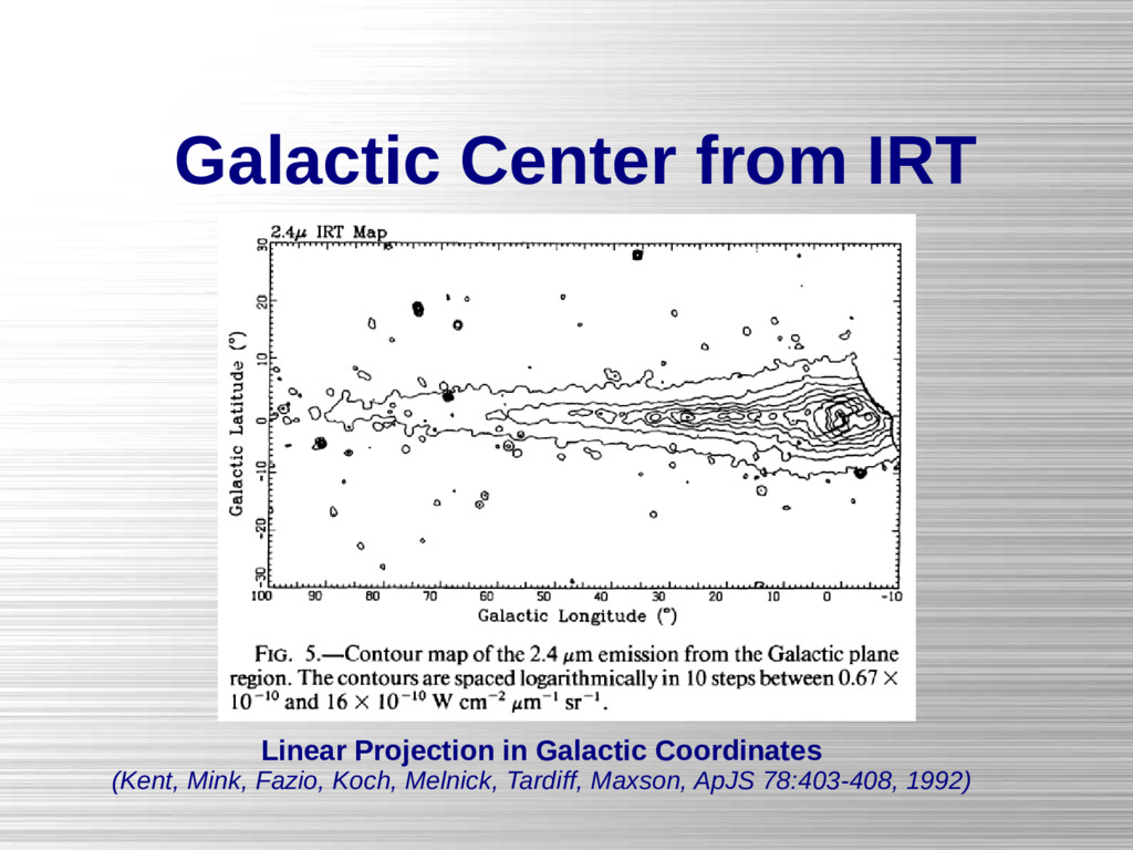
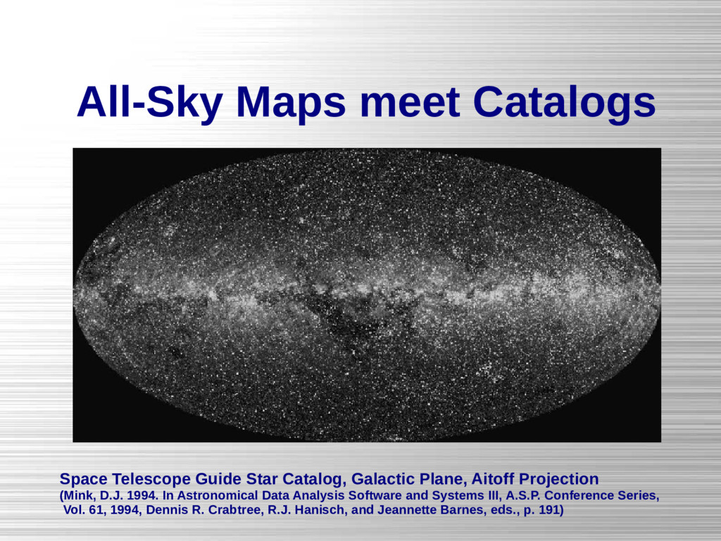
    Plane, Aitoff Projection (Mink, D.J. 1994. In Astronomical Data Analysis Software and Systems III, A.S.P. Conference Series, Vol. 61, 1994, Dennis R. Crabtree, R.J. Hanisch, and Jeannette Barnes, eds., p. 191)
  16. Galileo's Telescope Expands the Sky Polar projections centered on local

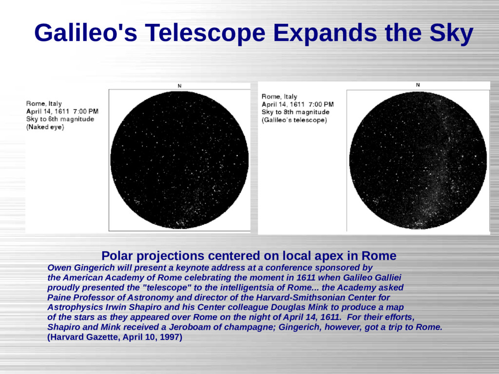
    apex in Rome Owen Gingerich will present a keynote address at a conference sponsored by the American Academy of Rome celebrating the moment in 1611 when Galileo Galliei proudly presented the "telescope" to the intelligentsia of Rome... the Academy asked Paine Professor of Astronomy and director of the Harvard-Smithsonian Center for Astrophysics Irwin Shapiro and his Center colleague Douglas Mink to produce a map of the stars as they appeared over Rome on the night of April 14, 1611. For their efforts, Shapiro and Mink received a Jeroboam of champagne; Gingerich, however, got a trip to Rome. (Harvard Gazette, April 10, 1997)
  17. Digitized Sky Survey Projection AURA (1993-1994), “The Digitized Sky Survey”

    CDROM Manual Doggett, J. (1997), http://gsss.stsci.edu/Software/GetImage/GetImage.htm Mink, Jessica (1999), “WCSTools: Image Astrometry Toolkit”, http://tdc-www.harvard.edu/software/wcstools/ PLTLABEL= 'E1356 ' /Observatory plate label PLATEID = '08MC ' /GSSS Plate ID REGION = 'XE429 ' /GSSS Region Name DATE-OBS= '23/03/55 ' /UT date of Observation UT = '06:02:00.00 ' /UT time of observation EPOCH = 1.9552226562500E+03 /Epoch of plate PLTRAH = 10 /Plate center RA PLTRAM = 7 / PLTRAS = 5.5528480000000E+01 / PLTDECSN= '+ ' /Plate center Dec PLTDECD = 17 / PLTDECM = 17 / PLTDECS = 3.8380860000000E+01 / EQUINOX = 2.0000000000000E+03 /Julian Reference frame equinox EXPOSURE= 5.0000000000000E+01 /Exposure time minutes BANDPASS= 8 /GSSS Bandpass code PLTGRADE= 1 /Plate grade PLTSCALE= 6.7200000000000E+01 /Plate Scale arcsec per mm SITELAT = '+33:24:24.00 ' /Latitude of Observatory SITELONG= '-116:51:48.00 ' /Longitude of Observatory TELESCOP= 'Palomar 48-inch Schmidt'/Telescope where plate taken CNPIX1 = 10748 /X corner (pixels) CNPIX2 = 2023 /Y corner DATATYPE= 'INTEGER*2 ' /Type of Data XPIXELSZ= 2.5284450000000E+01 /X pixel size microns YPIXELSZ= 2.5284450000000E+01 /Y pixel size microns PPO1 = 0.0000000000000E+00 /Orientation Coefficients PPO2 = 0.0000000000000E+00 / PPO3 = 1.7747471555000E+05 / PPO4 = 0.0000000000000E+00 / PPO5 = 0.0000000000000E+00 / PPO6 = 1.7747471555000E+05 / AMDX1 = 6.7241844402360E+01 /Plate solution x coefficients AMDX2 = 3.9757845495110E-01 / AMDX3 = -2.0498717200880E+02 / AMDX4 = -1.3607216767070E-05 / AMDX5 = -2.2201873529570E-05 / AMDX6 = 7.4284599162830E-07 / AMDX7 = 0.0000000000000E+00 / AMDX8 = 1.9162087720540E-06 / AMDX9 = -9.2146076767620E-10 / AMDX10 = 2.1089546241680E-06 / AMDX11 = -9.3945135632070E-08 / AMDY1 = 6.7256622034650E+01 /Plate solution y coefficients AMDY2 = -3.9844579471320E-01 / AMDY3 = -6.8591056129270E+01 / AMDY4 = -1.3176449798960E-05 / AMDY5 = -7.8391468151820E-06 / AMDY6 = -7.4802178840710E-07 / AMDY7 = 0.0000000000000E+00 / AMDY8 = 1.8834016180180E-06 / AMDY9 = -1.9452422448560E-07 / AMDY10 = 2.1574073462190E-06 / AMDY11 = -1.6009508926300E-08 /
  18. Digitized Sky Survey Projection Mink, Jessica (1999), “WCSTools: Image Astrometry

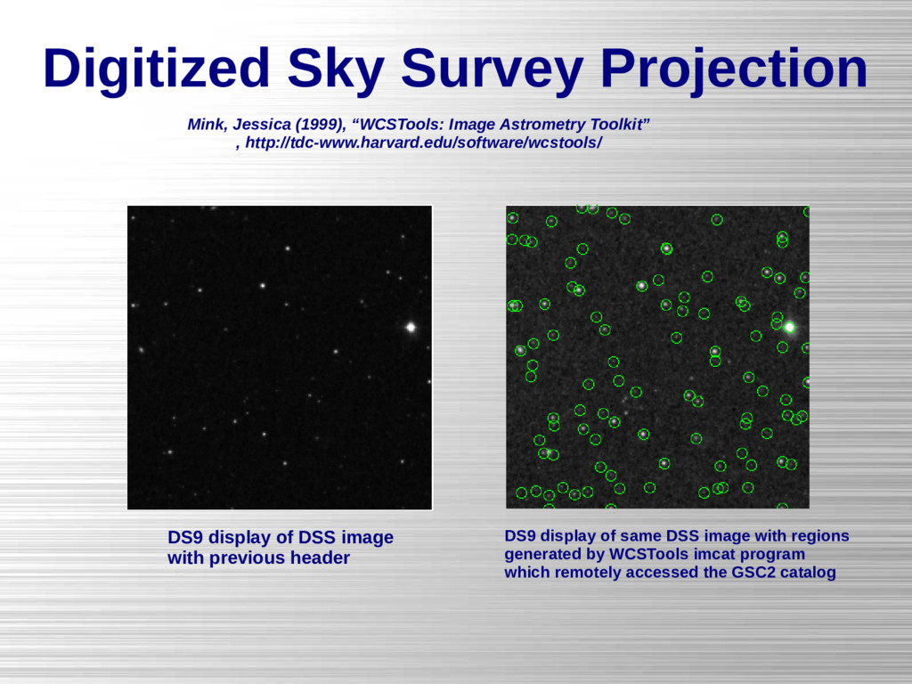
    Toolkit” , http://tdc-www.harvard.edu/software/wcstools/ DS9 display of DSS image with previous header DS9 display of same DSS image with regions generated by WCSTools imcat program which remotely accessed the GSC2 catalog
  19. AIPS Projections The eight most commonly-used projections of classic AIPS

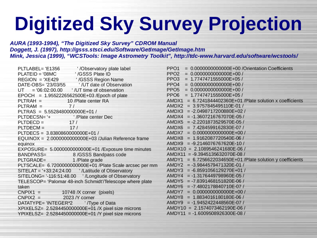
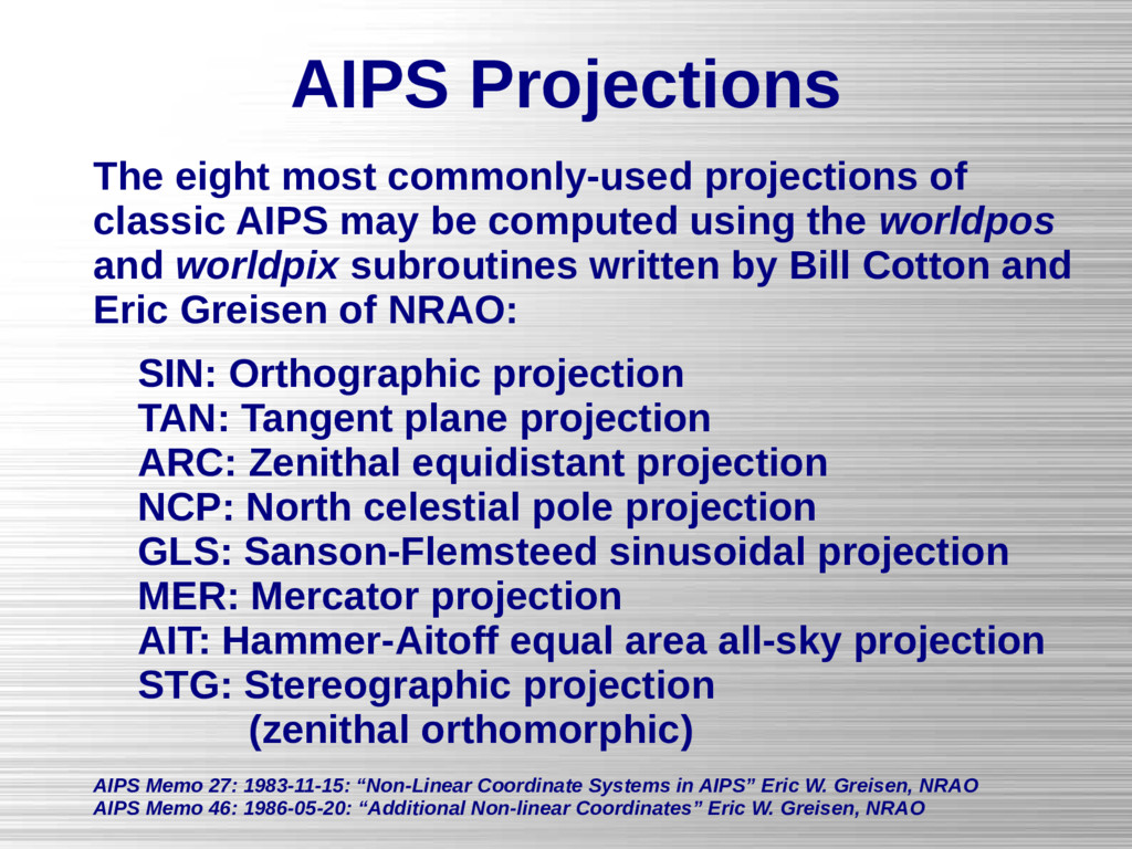
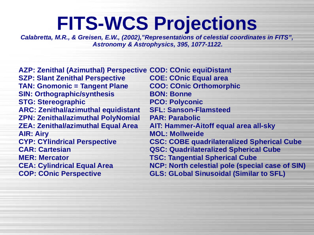
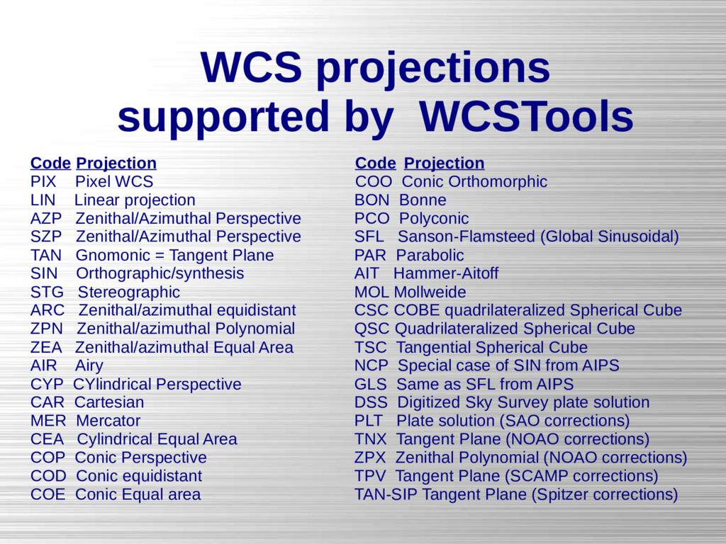
    may be computed using the worldpos and worldpix subroutines written by Bill Cotton and Eric Greisen of NRAO: SIN: Orthographic projection TAN: Tangent plane projection ARC: Zenithal equidistant projection NCP: North celestial pole projection GLS: Sanson-Flemsteed sinusoidal projection MER: Mercator projection AIT: Hammer-Aitoff equal area all-sky projection STG: Stereographic projection (zenithal orthomorphic) AIPS Memo 27: 1983-11-15: “Non-Linear Coordinate Systems in AIPS” Eric W. Greisen, NRAO AIPS Memo 46: 1986-05-20: “Additional Non-linear Coordinates” Eric W. Greisen, NRAO
  20. Fitting a WCS using WCSTools USNO-B1.0 Catalog plotted over image

    using telescope pointing FITS header with limited WCS keywords from telescope
  21. Fitting a WCS using WCSTools USNO-B1.0 Catalog plotted over image

    after imwcs WCS fit FITS header with WCS keywords after WCS fit using imwcs
  22. Finding Stars for WCSTools WCSTools supports several ways to find

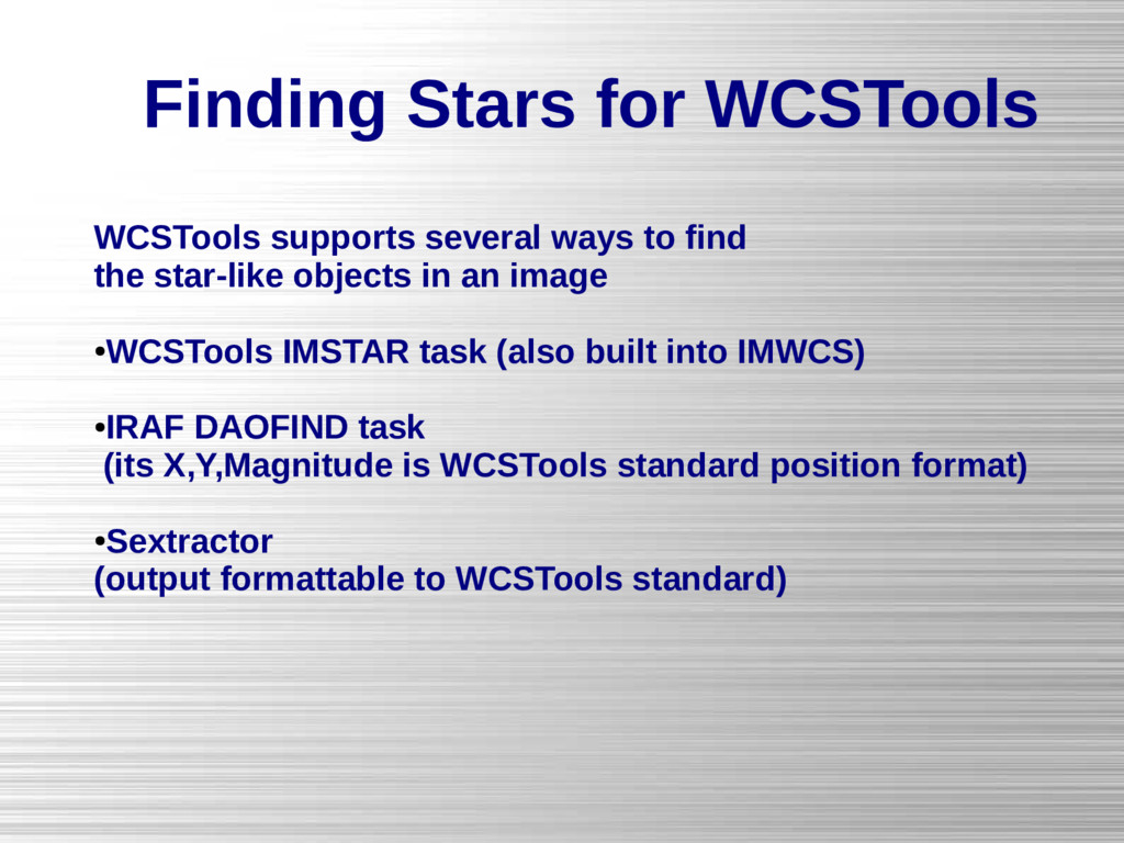
    the star-like objects in an image • WCSTools IMSTAR task (also built into IMWCS) • IRAF DAOFIND task (its X,Y,Magnitude is WCSTools standard position format) • Sextractor (output formattable to WCSTools standard)
  23. FITS-WCS Projections Calabretta, M.R., & Greisen, E.W., (2002),"Representations of celestial

    coordinates in FITS", Astronomy & Astrophysics, 395, 1077-1122. AZP: Zenithal (Azimuthal) Perspective SZP: Slant Zenithal Perspective TAN: Gnomonic = Tangent Plane SIN: Orthographic/synthesis STG: Stereographic ARC: Zenithal/azimuthal equidistant ZPN: Zenithal/azimuthal PolyNomial ZEA: Zenithal/azimuthal Equal Area AIR: Airy CYP: CYlindrical Perspective CAR: Cartesian MER: Mercator CEA: Cylindrical Equal Area COP: COnic Perspective COD: COnic equiDistant COE: COnic Equal area COO: COnic Orthomorphic BON: Bonne PCO: Polyconic SFL: Sanson-Flamsteed PAR: Parabolic AIT: Hammer-Aitoff equal area all-sky MOL: Mollweide CSC: COBE quadrilateralized Spherical Cube QSC: Quadrilateralized Spherical Cube TSC: Tangential Spherical Cube NCP: North celestial pole (special case of SIN) GLS: GLobal Sinusoidal (Similar to SFL)
  24. Testing Catalog Accuracy 216 1x1 degree fields from the 8K

    array on the KPNO 36-inch telescope cover half of the CfA Century survey, 50 degrees across the sky
  25. Testing Catalog Accuracy Differences between catalogs and WCS fits to

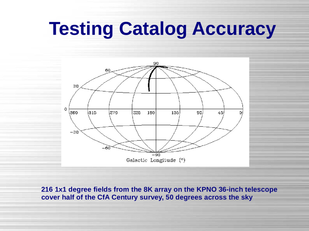
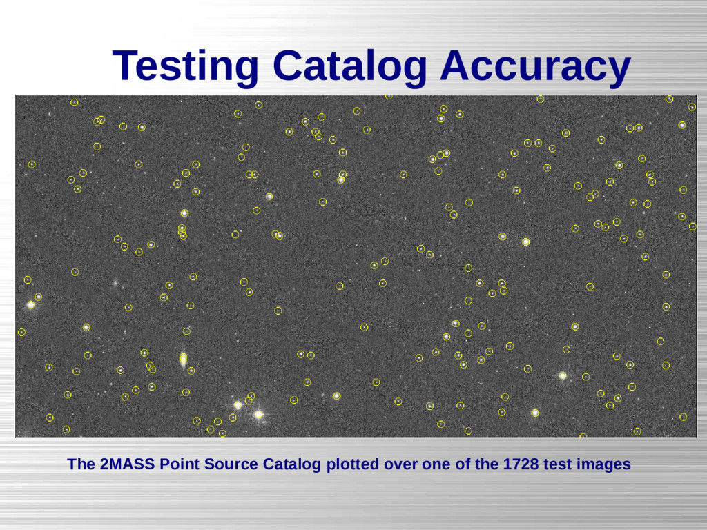
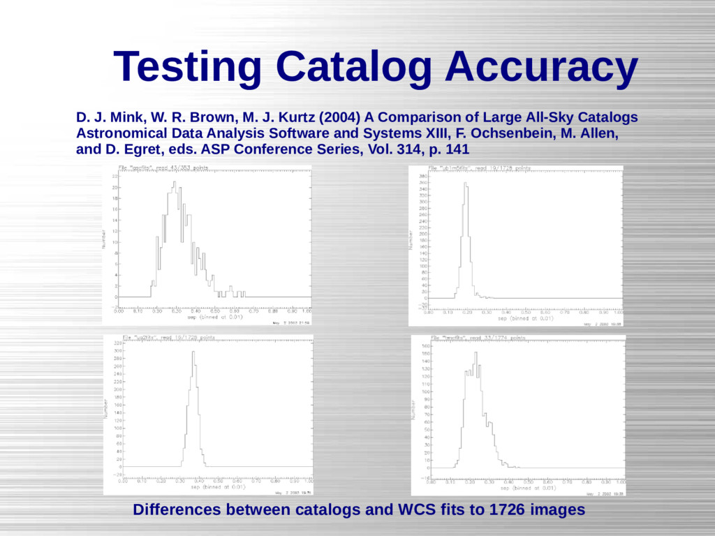
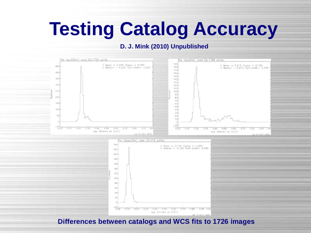
    1726 images D. J. Mink, W. R. Brown, M. J. Kurtz (2004) A Comparison of Large All-Sky Catalogs Astronomical Data Analysis Software and Systems XIII, F. Ochsenbein, M. Allen, and D. Egret, eds. ASP Conference Series, Vol. 314, p. 141
  26. Accommodating image distortions in WCSTools WCSTools supports several methods of

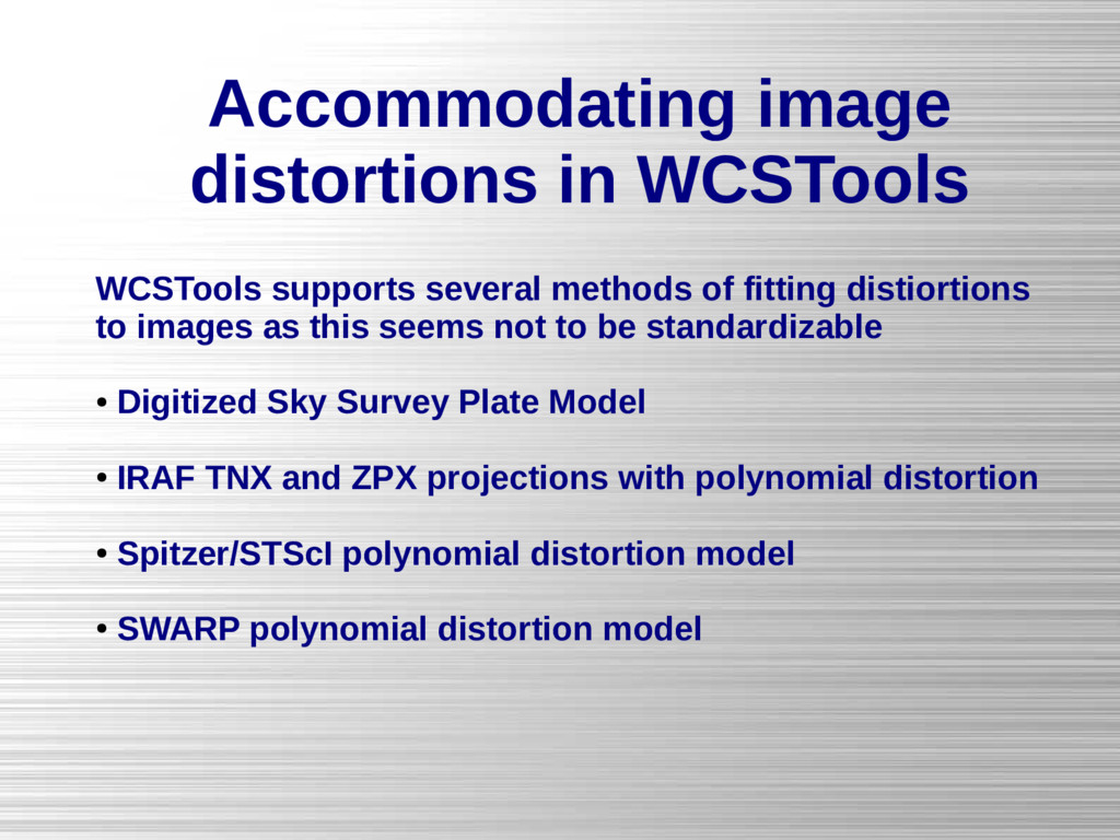
    fitting distiortions to images as this seems not to be standardizable • Digitized Sky Survey Plate Model • IRAF TNX and ZPX projections with polynomial distortion • Spitzer/STScI polynomial distortion model • SWARP polynomial distortion model
  27. WCS projections supported by WCSTools Code Projection Code Projection PIX

    Pixel WCS COO Conic Orthomorphic LIN Linear projection BON Bonne AZP Zenithal/Azimuthal Perspective PCO Polyconic SZP Zenithal/Azimuthal Perspective SFL Sanson-Flamsteed (Global Sinusoidal) TAN Gnomonic = Tangent Plane PAR Parabolic SIN Orthographic/synthesis AIT Hammer-Aitoff STG Stereographic MOL Mollweide ARC Zenithal/azimuthal equidistant CSC COBE quadrilateralized Spherical Cube ZPN Zenithal/azimuthal Polynomial QSC Quadrilateralized Spherical Cube ZEA Zenithal/azimuthal Equal Area TSC Tangential Spherical Cube AIR Airy NCP Special case of SIN from AIPS CYP CYlindrical Perspective GLS Same as SFL from AIPS CAR Cartesian DSS Digitized Sky Survey plate solution MER Mercator PLT Plate solution (SAO corrections) CEA Cylindrical Equal Area TNX Tangent Plane (NOAO corrections) COP Conic Perspective ZPX Zenithal Polynomial (NOAO corrections) COD Conic equidistant TPV Tangent Plane (SCAMP corrections) COE Conic Equal area TAN-SIP Tangent Plane (Spitzer corrections)
  28. Putting Positions on Harvard's Plates From hand-written cards and logbooks

    Mink, D.; Doane, A.; Simcoe, R.; Los, E.; Grindlay, J. (2006). "The Harvard Plate Scanning Project" in Virtual Observatory: Plate Content Digitization, Archive Mining and Image Sequence Processing, iAstro workshop, Sofia, Bulgaria, 2005 proceedings, Sophia: Heron Press Ltd.
  29. Putting Positions on Harvard's Plates From three floors of cabinets

    of glass plates Mink, D.; Doane, A.; Simcoe, R.; Los, E.; Grindlay, J. (2006). "The Harvard Plate Scanning Project" in Virtual Observatory: Plate Content Digitization, Archive Mining and Image Sequence Processing, iAstro workshop, Sofia, Bulgaria, 2005 proceedings, Sophia: Heron Press Ltd.
  30. Putting Positions on Harvard's Plates Zoom in and overplot stars

    using WCS M44 in Plate MC21438 M44 in Plate MC21438 with Tycho 2 Catalog stars marked
  31. sethead sets values of keywords in FITS Headers Each keyword

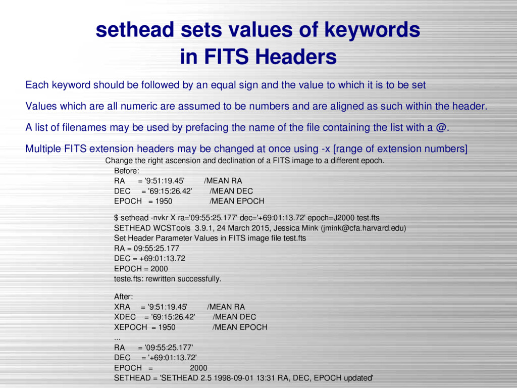
    should be followed by an equal sign and the value to which it is to be set Values which are all numeric are assumed to be numbers and are aligned as such within the header. A list of filenames may be used by prefacing the name of the file containing the list with a @. Multiple FITS extension headers may be changed at once using -x [range of extension numbers] Change the right ascension and declination of a FITS image to a different epoch. Before: RA = '9:51:19.45' /MEAN RA DEC = '69:15:26.42' /MEAN DEC EPOCH = 1950 /MEAN EPOCH $ sethead -nvkr X ra='09:55:25.177' dec='+69:01:13.72' epoch=J2000 test.fts SETHEAD WCSTools 3.9.1, 24 March 2015, Jessica Mink ([email protected]) Set Header Parameter Values in FITS image file test.fts RA = 09:55:25.177 DEC = +69:01:13.72 EPOCH = 2000 teste.fts: rewritten successfully. After: XRA = '9:51:19.45' /MEAN RA XDEC = '69:15:26.42' /MEAN DEC XEPOCH = 1950 /MEAN EPOCH ... RA = '09:55:25.177' DEC = '+69:01:13.72' EPOCH = 2000 SETHEAD = 'SETHEAD 2.5 1998-09-01 13:31 RA, DEC, EPOCH updated'
  32. gethead extracts information from FITS headers Keyword names may be

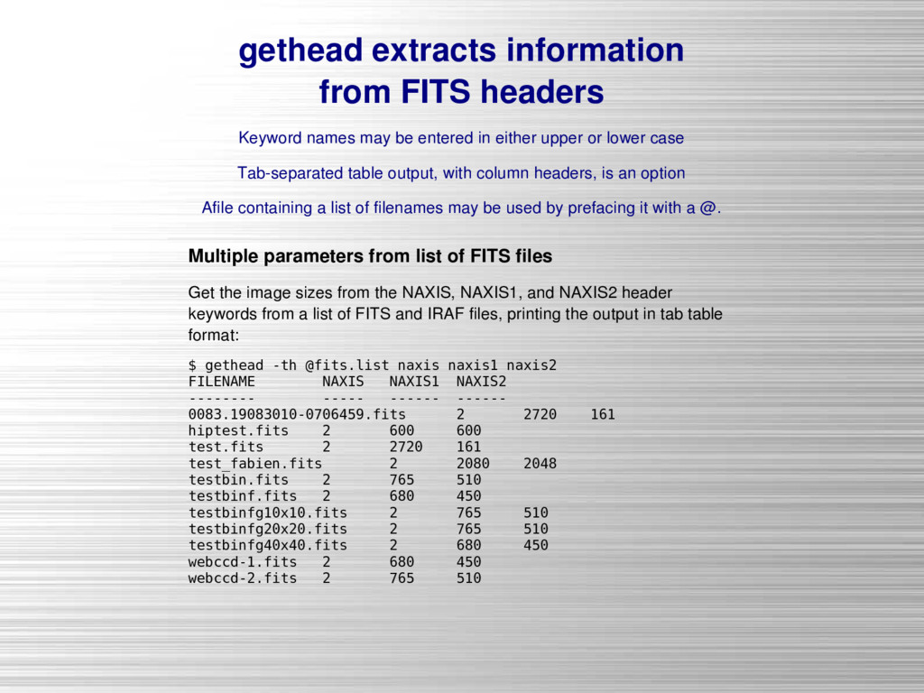
    entered in either upper or lower case Tab-separated table output, with column headers, is an option Afile containing a list of filenames may be used by prefacing it with a @. Multiple parameters from list of FITS files Get the image sizes from the NAXIS, NAXIS1, and NAXIS2 header keywords from a list of FITS and IRAF files, printing the output in tab table format: $ gethead -th @fits.list naxis naxis1 naxis2 FILENAME NAXIS NAXIS1 NAXIS2 -------- ----- ------ ------ 0083.19083010-0706459.fits 2 2720 161 hiptest.fits 2 600 600 test.fits 2 2720 161 test_fabien.fits 2 2080 2048 testbin.fits 2 765 510 testbinf.fits 2 680 450 testbinfg10x10.fits 2 765 510 testbinfg20x20.fits 2 765 510 testbinfg40x40.fits 2 680 450 webccd-1.fits 2 680 450 webccd-2.fits 2 765 510
  33. Redshifting Into the Universe Before Sky Removal After Sky Removal

    After Sky Removal Before Sky Removal 12,553 Spectra from the Hectospec SHELS survey