Upgrade to Pro — share decks privately, control downloads, hide ads and more …

Geoinformatics Technologist : Playing it safe o...

Geoinformatics Technologist : Playing it safe or riding the wave?

Avatar for Prasong Patheepphoemphong

Prasong Patheepphoemphong

August 14, 2025
Tweet

Transcript

  1. Prasong Patheepphoemphong chief executive officer at i-bitz company limited Geoinformatics

    Technologist : Playing it safe or riding the wave? MHESIFAIR 2025, 16 August 2025 ภูมิสารสนเทศ : อาชีพ ที่ ม ั ่ นคงหรือแค่กระแส?
  2. Introduction Our Company i-bitz, the geomatics company which has highly

    experienced in geoinformatic technology. We are reaching to provide inventive and innovative solutions to solve location problem related to geoinformatic technology. Vallaris is product from our experience more than 20 years MHESIFAIR 2025, 16 August 2025
  3. The geospatial evolution from classic to modern geospatial software platform

    Desktop GIS Data on you local storage and limit on large scale processing, and publishing Internet Mapping Web 2.0 and 3.0 make mapping shift on the web based. immersive Mapping New devices to interact to data. Anytime AnyWhere
  4. Spatial analysis will increasingly be at the heart of future

    business strategies. The year of Location Intelligence Report Spatial Analysis in 2025: Key Trends of 32 1 Spatial Analysis in 2025: Key Trends AI and machine learning will make spatial analysis more intuitive, e ffi cient, and automated to drive critical business insights across more use cases than ever before. Smarter Access to high-res data will enable businesses to tap into and uncover new kinds of hyper-local insights to fuel more targeted, intelligent and e ff ective business strategies. Granular Stronger regulatory frameworks and data governance practices will ensure that often sensitive spatial data remains secure and used in only ethical ways. Security New low-code/no-code tools will make spatial analysis accessible to non-technical users, further cementing spatial data as a driver of business intelligence. Accessible Edge computing and cloud-based solutions will make it possible to access, process, analyze, and glean valuable insights from spatial data in real-time. Faster MHESIFAIR 2025, 16 August 2025
  5. ASEAN Geospatial Analytics Market Size ~760 MILLION $ 2025 ~1,350

    MILLION $ 2030 12.18% CAGR Source: Mordor Intelligence : ASEAN Geospatial Analytics Market Size & Share Analysis - Growth Trends & Forecasts (2025 - 2030) Source: https://www.mordorintelligence.com/industry-reports/asean-geospatial-analytics-market integration data by claude.ai
  6. Geospatial industrial Growth 2023 150+ 25M 15M 15K sources: Digital

    Economy Promotion Agency (DEPA) Annual Industry Survey 2023, Board of Investment (BOI) Thailand Digital Industry Report 2023 integration data by claude.ai geospatial companies Professional Workforce Government investment in Geospatial data Private Sector investment in Geospatial data
  7. Traditional GIS dominance Desktop-based solutions Limited mobile adoption Limited cloud

    processing 2014 - 2016 Market Evolution phase In the past 10 years, from 2014 to 2024, Thailand's geospatial technology industry has undergone signi fi cant changes, transitioning from traditional geographic information technology used on personal computers to collaborative work on large-scale computer networks. Similarly, with the increasing volume and diversity of geographic information data, the methods of management, access, and processing have become di ff erent from the past. As a result, modern geographic information systems must adapt to accommodate these changes, and we are seeing more modern geospatial platforms emerging. Cloud transition begins Mobile solutions emerge Smart city initiatives start 2017 -2019 Digital transformation acceleration COVID-19 impact Remote solutions demand 2020 - 2022 Could Native geospatial Cloud-base processing Modern Geospatial platform Real-time processing capability 2025 - Future AI/ML integration Platform consolidation Metaverse emergence 2023 - 2024 sources: GISTDA annual reports, THEOS mission data, Ministry of Agriculture and Cooperatives, Department of Disaster Prevention and Mitigation, Royal Forest Department, Academic research publications, International space agency reports integration data by claude.ai Ten years ago, today, and in the future
  8. Urban Planning Public Services Thailand Geospatial Market Segment by industry

    2023 20% 15% 25% 40% Agriculture Transportation • Smart City initiative • Land management • Infrastructure planning • Public safety • Environmental monitoring • Property development • Construction planning • Facility management • Market analysis • Precision farming • Crop monitoring • Yield optimization • Agricultural planning • Fleet management • Route optimization • Last-mile delivery • Infrastructure planning sources: Government budget allocation, Digital Economy Promotion Agency (DEPA), BOI incentives, Private sector investment, International cooperation projects
  9. • Smart City initiative • Land management • Infrastructure planning

    • Public safety • Environmental monitoring Thailand Geospatial Market Growth Segment by industry 2014 - 2024 • Property development • Construction planning • Facility management • Market analysis • Precision farming • Crop monitoring • Yield optimization • Agricultural planning • Fleet management • Route optimization • Last-mile delivery • Infrastructure planning 25% 17% 12% 18% Urban Planning Public Services Agriculture Transportation CAGR CAGR CAGR CAGR sources: Government budget allocation, Digital Economy Promotion Agency (DEPA), BOI incentives, Private sector investment, International cooperation projects
  10. Work force Skill and Project complexity has been change over

    the years since 2014 to 2024 Skill & Complexity Distribution Change Most are Traditional GIS professional 2014 Skill Distribution Growing on Geospatial programming and Geospatial Data Scientist 2024 Skill Distribution Basic Mapping project are majority in the solutions 2014 Complexity Solution become more advance analysis and Integration solution 2024 Complexity Skill 2014 Programming 20% Data Scientist 20% Traditional GIS 60% sources: GISTDA annual reports, THEOS mission data, Ministry of Agriculture and Cooperatives, Department of Disaster Prevention and Mitigation, Royal Forest Department, Academic research publications, International space agency reports integration data by claude.ai Programming 35% Data Scientist 35% Traditional GIS 30% Skill 2024 Advance Analysis 30% Integration 20% Basic Mapping 50% Project 2014 Advance Analysis 40% Integration 40% Basic Mapping 20% Project 2024
  11. Big Player in Thailand Geospatial Market GISTDA NECTEC Government AIT

    14 Universities Academic > 10 Companies DEPA Private sources: Mordor Intelligence : ASEAN Geospatial Analytics Market Size & Share Analysis - Growth Trends & Forecasts (2025 - 2030), Future of Jobs Report 2025January 2025, Digital Economy Promotion Agency (DEPA) integration data by claude.ai
  12. Career Spectrum Of the geoinformatics industry Over 117,000 Geoinformatics position

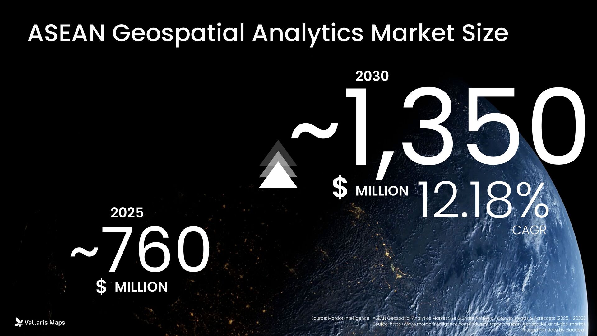
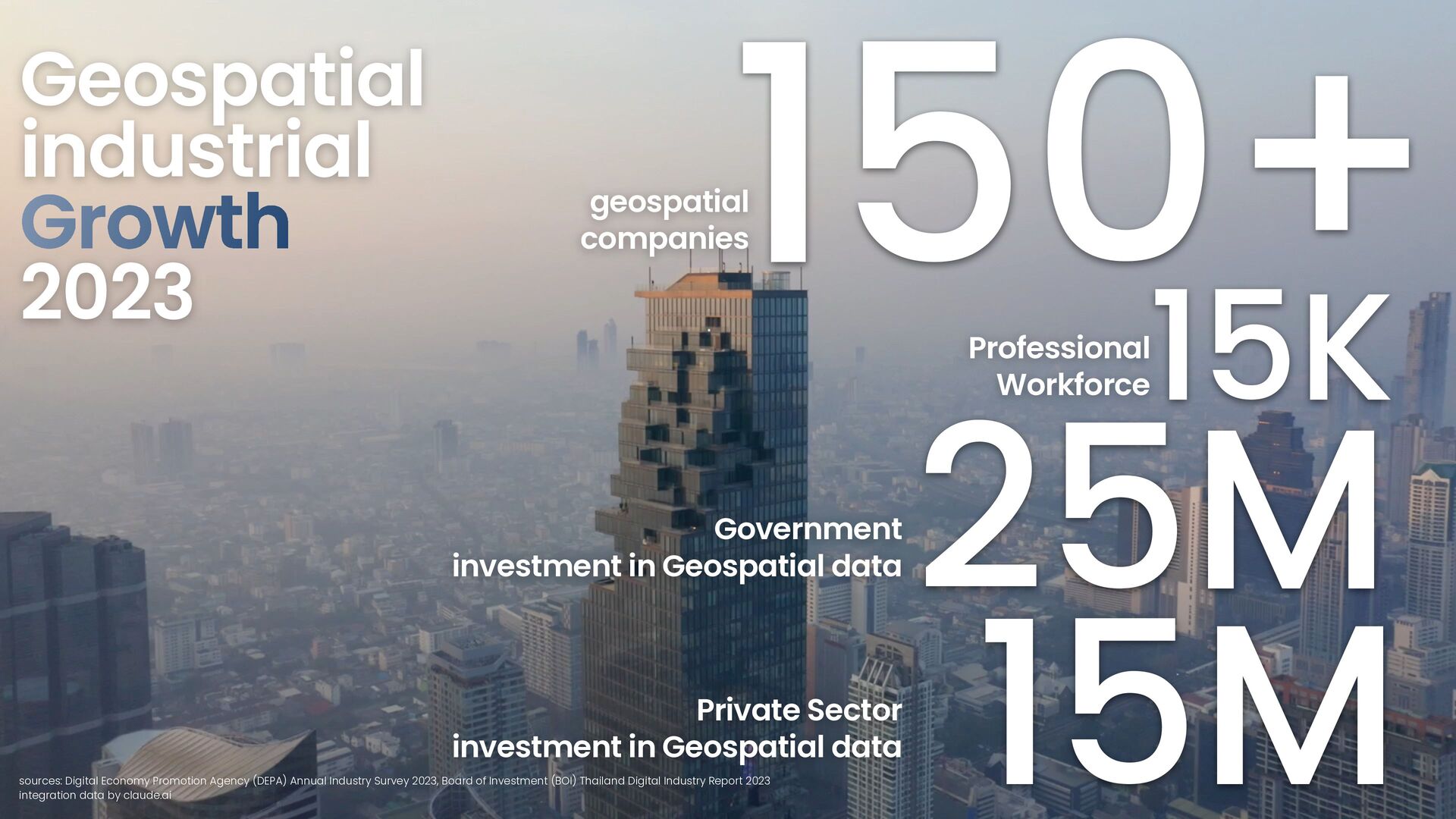
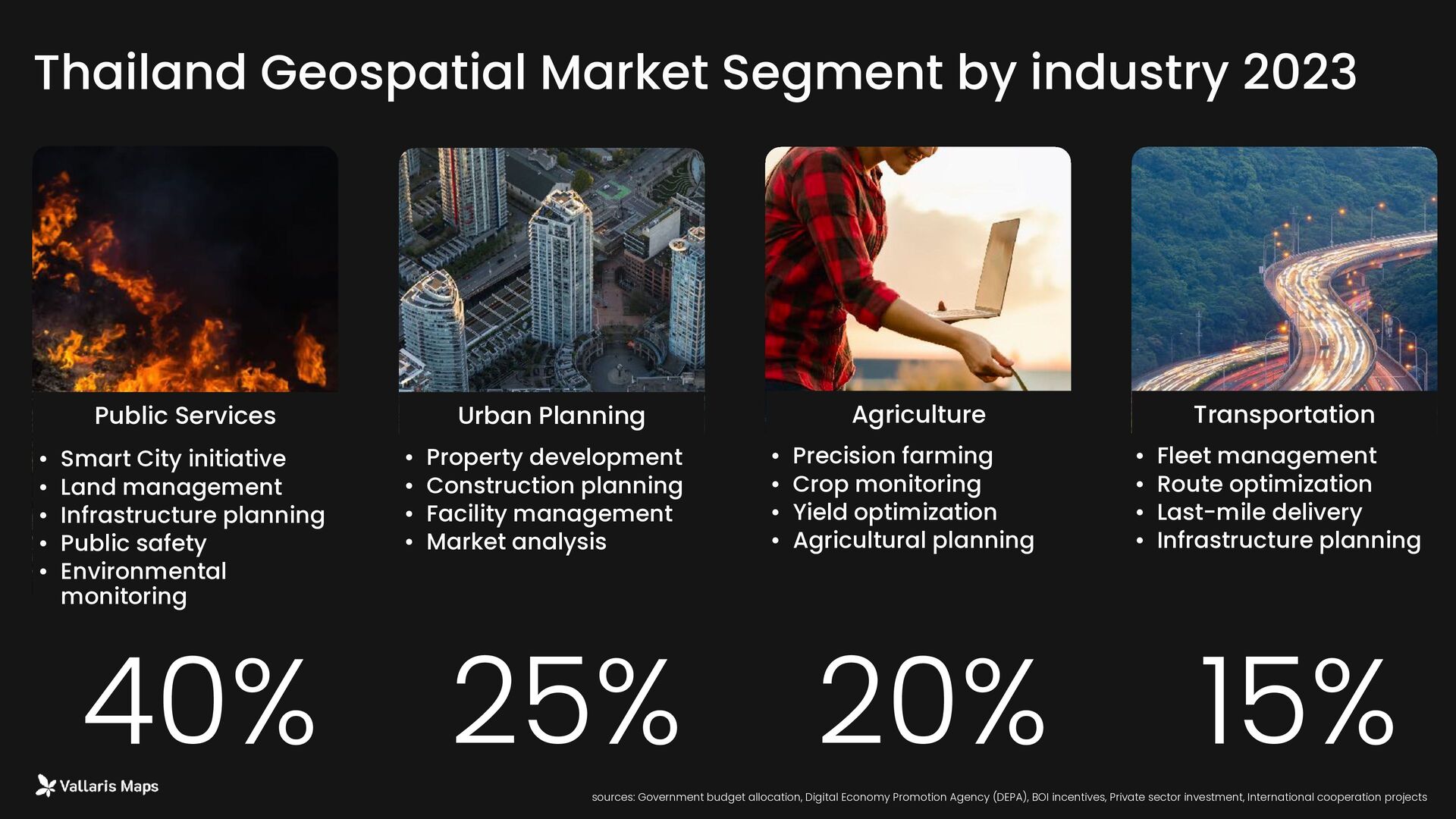
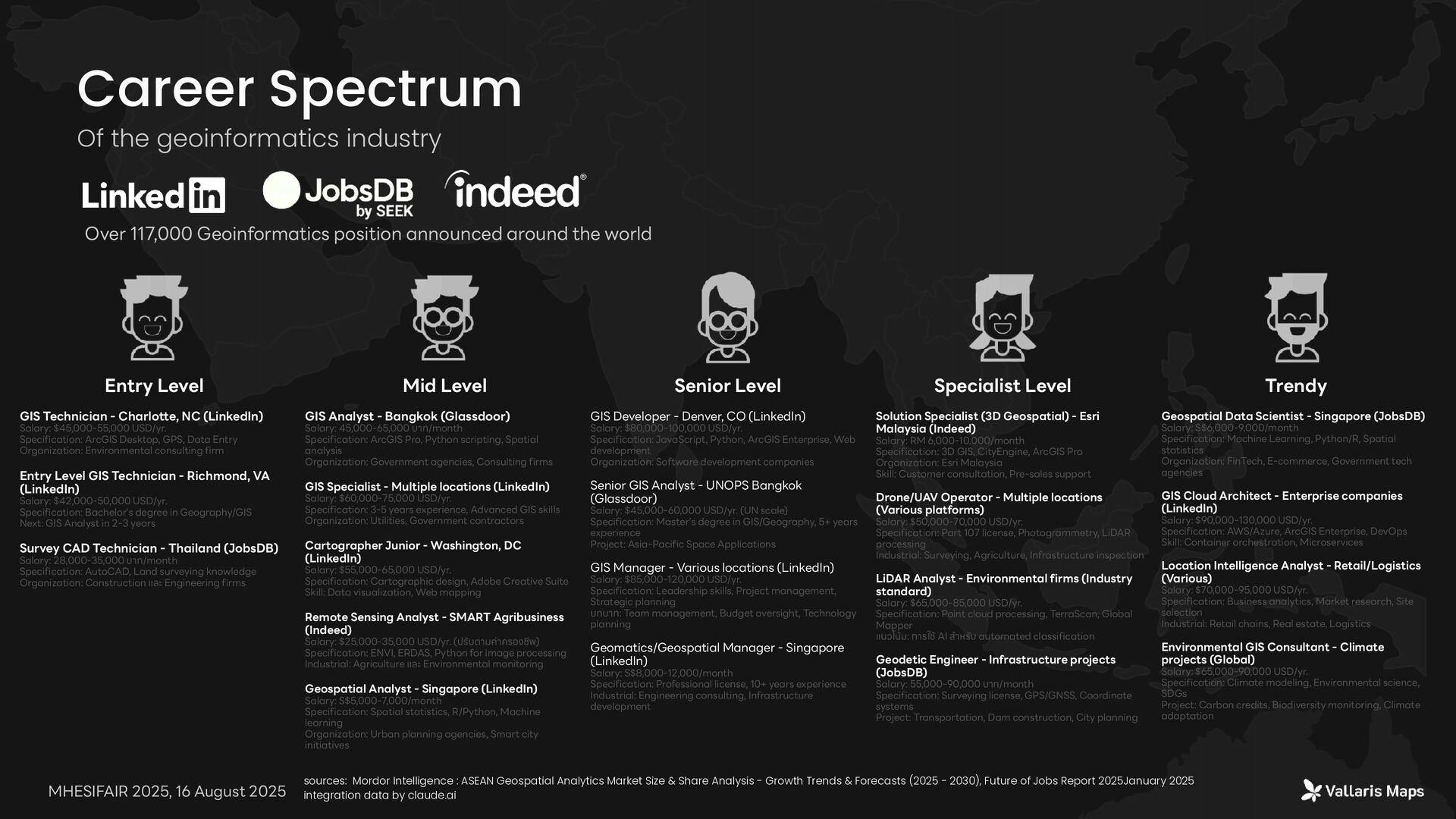
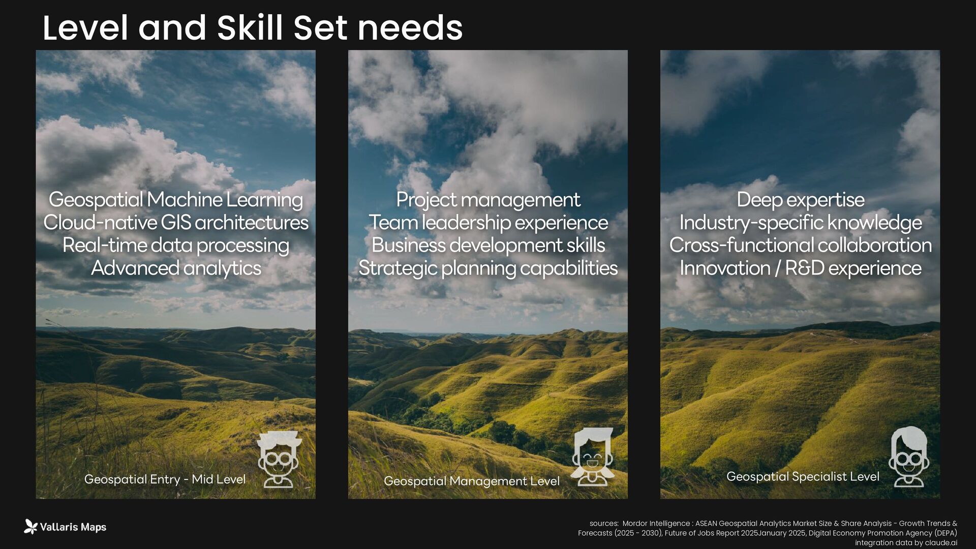
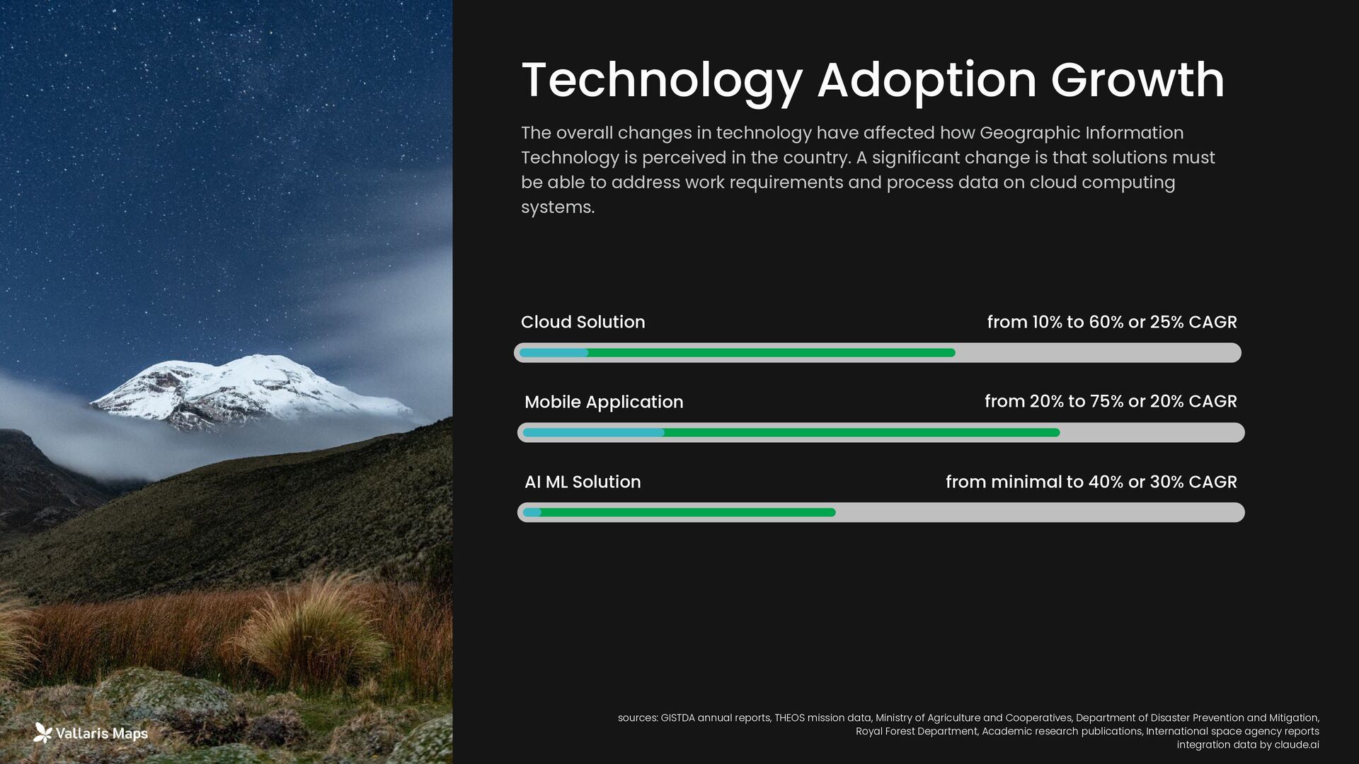
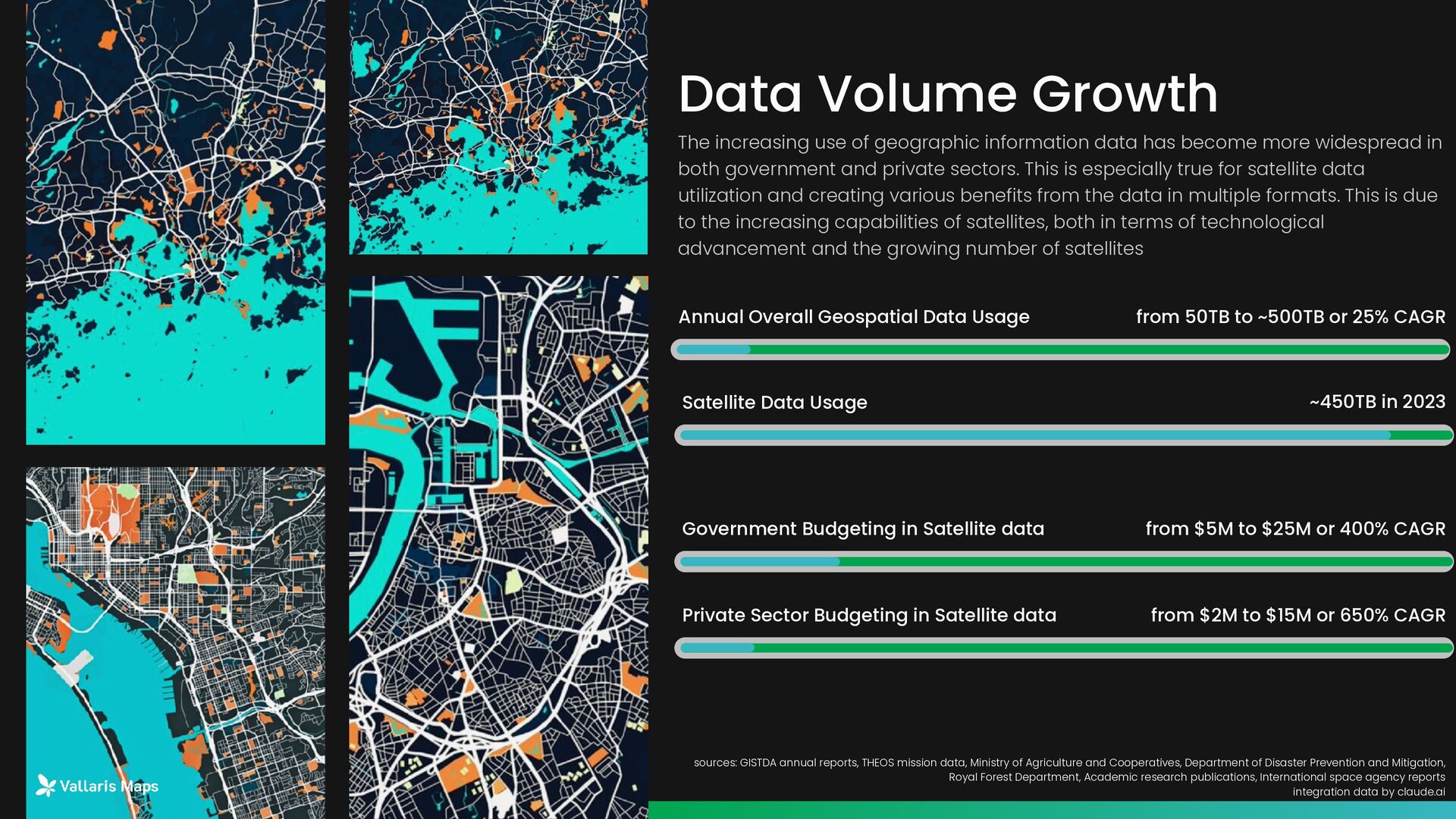
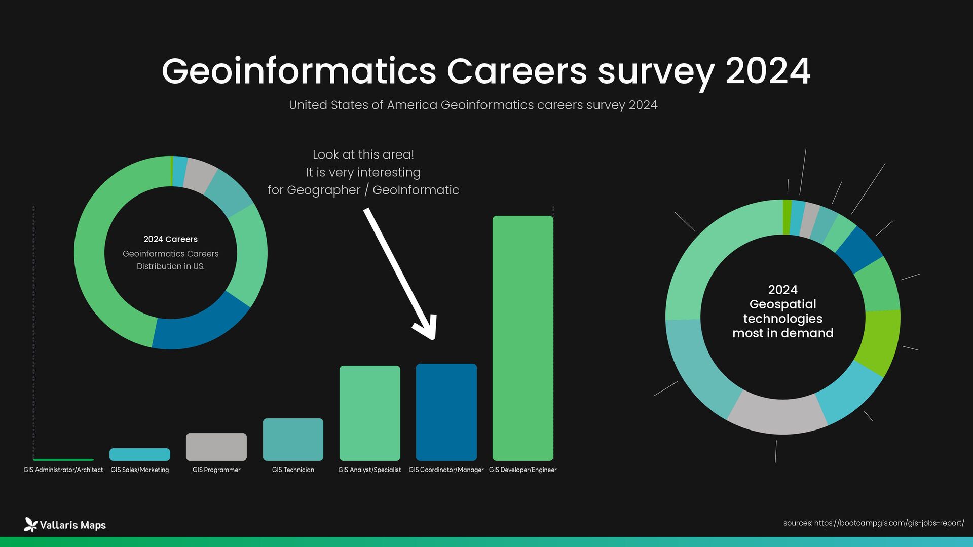
    announced around the world Entry Level GIS Technician - Charlotte, NC (LinkedIn) Salary: $45,000-55,000 USD/yr. Specification: ArcGIS Desktop, GPS, Data Entry Organization: Environmental consulting firm Entry Level GIS Technician - Richmond, VA (LinkedIn) Salary: $42,000-50,000 USD/yr. Specification: Bachelor's degree in Geography/GIS Next: GIS Analyst in 2-3 years Survey CAD Technician - Thailand (JobsDB) Salary: 28,000-35,000 บาท/month Specification: AutoCAD, Land surveying knowledge Organization: Construction และ Engineering firms Mid Level GIS Analyst - Bangkok (Glassdoor) Salary: 45,000-65,000 บาท/month Specification: ArcGIS Pro, Python scripting, Spatial analysis Organization: Government agencies, Consulting firms GIS Specialist - Multiple locations (LinkedIn) Salary: $60,000-75,000 USD/yr. Specification: 3-5 years experience, Advanced GIS skills Organization: Utilities, Government contractors Cartographer Junior - Washington, DC (LinkedIn) Salary: $55,000-65,000 USD/yr. Specification: Cartographic design, Adobe Creative Suite Skill: Data visualization, Web mapping Remote Sensing Analyst - SMART Agribusiness (Indeed) Salary: $25,000-35,000 USD/yr. (ปรับตามค่าครองชีพ) Specification: ENVI, ERDAS, Python for image processing Industrial: Agriculture และ Environmental monitoring Geospatial Analyst - Singapore (LinkedIn) Salary: S$5,000-7,000/month Specification: Spatial statistics, R/Python, Machine learning Organization: Urban planning agencies, Smart city initiatives Senior Level GIS Developer - Denver, CO (LinkedIn) Salary: $80,000-100,000 USD/yr. Specification: JavaScript, Python, ArcGIS Enterprise, Web development Organization: Software development companies Senior GIS Analyst - UNOPS Bangkok (Glassdoor) Salary: $45,000-60,000 USD/yr. (UN scale) Specification: Master's degree in GIS/Geography, 5+ years experience Project: Asia-Pacific Space Applications GIS Manager - Various locations (LinkedIn) Salary: $85,000-120,000 USD/yr. Specification: Leadership skills, Project management, Strategic planning บทบาท: Team management, Budget oversight, Technology planning Geomatics/Geospatial Manager - Singapore (LinkedIn) Salary: S$8,000-12,000/month Specification: Professional license, 10+ years experience Industrial: Engineering consulting, Infrastructure development Specialist Level Solution Specialist (3D Geospatial) - Esri Malaysia (Indeed) Salary: RM 6,000-10,000/month Specification: 3D GIS, CityEngine, ArcGIS Pro Organization: Esri Malaysia Skill: Customer consultation, Pre-sales support Drone/UAV Operator - Multiple locations (Various platforms) Salary: $50,000-70,000 USD/yr. Specification: Part 107 license, Photogrammetry, LiDAR processing Industrial: Surveying, Agriculture, Infrastructure inspection LiDAR Analyst - Environmental firms (Industry standard) Salary: $65,000-85,000 USD/yr. Specification: Point cloud processing, TerraScan, Global Mapper แนวโน้ม: การใช้ AI ส ำ หรับ automated classification Geodetic Engineer - Infrastructure projects (JobsDB) Salary: 55,000-90,000 บาท/month Specification: Surveying license, GPS/GNSS, Coordinate systems Project: Transportation, Dam construction, City planning Geospatial Data Scientist - Singapore (JobsDB) Salary: S$6,000-9,000/month Specification: Machine Learning, Python/R, Spatial statistics Organization: FinTech, E-commerce, Government tech agencies GIS Cloud Architect - Enterprise companies (LinkedIn) Salary: $90,000-130,000 USD/yr. Specification: AWS/Azure, ArcGIS Enterprise, DevOps Skill: Container orchestration, Microservices Location Intelligence Analyst - Retail/Logistics (Various) Salary: $70,000-95,000 USD/yr. Specification: Business analytics, Market research, Site selection Industrial: Retail chains, Real estate, Logistics Environmental GIS Consultant - Climate projects (Global) Salary: $65,000-90,000 USD/yr. Specification: Climate modeling, Environmental science, SDGs Project: Carbon credits, Biodiversity monitoring, Climate adaptation Trendy MHESIFAIR 2025, 16 August 2025 sources: Mordor Intelligence : ASEAN Geospatial Analytics Market Size & Share Analysis - Growth Trends & Forecasts (2025 - 2030), Future of Jobs Report 2025January 2025 integration data by claude.ai
  13. GIS Developer Skill: Python, JavaScript Salary: 175,000 - 250,000 thb/month

    Geospatial Data Scientist Skill: Python, R, Machine Learning, SQL, Spatial Analytics Salary: 200,000 - 320,000 thb/month Remote Sensing Specialist Skill: Python, Google Earth Engine Salary: 195,000 - 270,000 thb/month Thailand (~40 ต ำ แหน่ง) Malaysia Singapore Salary: 22,000-62,000 บาท/month Specificationสูง: GIS Engineer ส ำ หรับ Oil & Gas เน้นทักษะ: ArcGIS, AutoCAD, Land Surveying Salary: 35,000-80,000 บาท/month (Entry level) Salary: 60,000-120,000 บาท/month (Experienced) หน่วยงาน: GISTDA, PTT, CP Group, Siemens Salary: 100,000-250,000 บาท/month Specificationสูง: Smart City applications เน้นทักษะ: IoT, Data Analytics, Urban Planning Career in the Market Of the geoinformatics industry Over 117,000 Geoinformatics position announced around the world Hongkong Australia Salary: ~406,600 บาท/month (Exprienced) Japan Salary: ~211,700 บาท/month (Exprienced) Salary: ~205,600 บาท/month (Exprienced) MHESIFAIR 2025, 16 August 2025 sources: Mordor Intelligence : ASEAN Geospatial Analytics Market Size & Share Analysis - Growth Trends & Forecasts (2025 - 2030), LinkedIn, JobsDB, indeed integration data by claude.ai
  14. Thailand Malaysia Singapore Salary Survey SEA market Of the geoinformatics

    industry Over 117,000 Geoinformatics position announced around the world Indonesia 42,000-58,000 บาท/month 70,000-105,000 บาท/ month 140,000-210,000 บาท/ month Philippine 35,000-55,000 บาท/month 55,000-85,000 บาท/month 85,000-140,000 บาท/ month 28,000-38,000 บาท/month 50,000-70,000 บาท/month 85,000-125,000 บาท/ month 120,000-160,000 บาท/ month 180,000-240,000 บาท/ month 300,000-450,000 บาท/ month 25,000-35,000 บาท/month 45,000-65,000 บาท/month 80,000-120,000 บาท/ month Entry - Mid Level Specialist Level Management ‣ GIS Technician: 35,000-55,000 ‣ GIS Analyst: 55,000-85,000 ‣ GIS Developer: 75,000-120,000 ‣ Remote Sensing Specialist: 70,000-110,000 ‣ Geospatial Data Scientist: 95,000-150,000 ‣ LiDAR Analyst: 65,000-100,000 ‣ Drone/UAV Operator: 50,000-80,000 ‣ GIS Cloud Architect: 120,000-180,000 ‣ GIS Project Manager: 110,000-170,000 ‣ GIS Manager: 130,000-200,000 ‣ Geospatial Director: 180,000-280,000 MHESIFAIR 2025, 16 August 2025 sources: Mordor Intelligence : ASEAN Geospatial Analytics Market Size & Share Analysis - Growth Trends & Forecasts (2025 - 2030), LinkedIn, JobsDB, indeed integration data by claude.ai
  15. Segment and Skill Set Of the geoinformatics industry Over 117,000

    Geoinformatics position announced around the world Smart Cities Urban Planning Public Services 50% 40% 55% Agriculture • Satellite data Analysis • Carbon Monitoring • Real-Time monitoring • Predictive monitoring • IoT Integration • Real-Time Analytics • Precision farming • Crop monitoring sources: Mordor Intelligence : ASEAN Geospatial Analytics Market Size & Share Analysis - Growth Trends & Forecasts (2025 - 2030), Future of Jobs Report 2025January 2025, Digital Economy Promotion Agency (DEPA) integration data by claude.ai
  16. The overall changes in technology have affected how Geographic Information

    Technology is perceived in the country. A significant change is that solutions must be able to address work requirements and process data on cloud computing systems. Skill Shift up and down Desktop GIS Stable -25% Manual Digitizing / Data Creation Stable -40% Traditional Cartography Stable -30% Artificial Intelligence / Machine Learning Integration Stable 85% Cloud-Based GIS Stable Real-Time Data Processing Stable Mobile GIS Development Stable 75% 60% 45% sources: Mordor Intelligence : ASEAN Geospatial Analytics Market Size & Share Analysis - Growth Trends & Forecasts (2025 - 2030), Future of Jobs Report 2025January 2025, Digital Economy Promotion Agency (DEPA) integration data by claude.ai
  17. Geospatial Entry - Mid Level Geospatial Specialist Level Geospatial Management

    Level Deep expertise Industry-specific knowledge Cross-functional collaboration Innovation / R&D experience Project management Team leadership experience Business development skills Strategic planning capabilities Geospatial Machine Learning Cloud-native GIS architectures Real-time data processing Advanced analytics Level and Skill Set needs sources: Mordor Intelligence : ASEAN Geospatial Analytics Market Size & Share Analysis - Growth Trends & Forecasts (2025 - 2030), Future of Jobs Report 2025January 2025, Digital Economy Promotion Agency (DEPA) integration data by claude.ai
  18. The overall changes in technology have affected how Geographic Information

    Technology is perceived in the country. A significant change is that solutions must be able to address work requirements and process data on cloud computing systems. Technology Adoption Growth from 10% to 60% or 25% CAGR Cloud Solution Mobile Application AI ML Solution from 20% to 75% or 20% CAGR from minimal to 40% or 30% CAGR sources: GISTDA annual reports, THEOS mission data, Ministry of Agriculture and Cooperatives, Department of Disaster Prevention and Mitigation, Royal Forest Department, Academic research publications, International space agency reports integration data by claude.ai
  19. The increasing use of geographic information data has become more

    widespread in both government and private sectors. This is especially true for satellite data utilization and creating various benefits from the data in multiple formats. This is due to the increasing capabilities of satellites, both in terms of technological advancement and the growing number of satellites Data Volume Growth from 50TB to ~500TB or 25% CAGR Annual Overall Geospatial Data Usage Satellite Data Usage ~450TB in 2023 sources: GISTDA annual reports, THEOS mission data, Ministry of Agriculture and Cooperatives, Department of Disaster Prevention and Mitigation, Royal Forest Department, Academic research publications, International space agency reports integration data by claude.ai Government Budgeting in Satellite data from $5M to $25M or 400% CAGR Private Sector Budgeting in Satellite data from $2M to $15M or 650% CAGR
  20. GIS Administrator/Architect GIS Sales/Marketing GIS Programmer GIS Technician GIS Analyst/Specialist

    GIS Coordinator/Manager GIS Developer/Engineer 8,636 3,423 3,362 1,509 981 455 70 United States of America Geoinformatics careers survey 2024 Geoinformatics Careers survey 2024 sources: https://bootcampgis.com/gis-jobs-report/ 47% 19% 18% 8% 5% 2% Geoinformatics Careers Distribution in US. 2024 Careers Data Science 25% Image Processing/Remote Sensing 17% Modeling 14% LiDAR 10% Python 10% Land Survey 8% Google Cloud 5% Photogrammetry 3% HTML 3% AWS 2% UAV/UAS/Drone 2% BIM 1% 2024 Geospatial technologies most in demand Look at this area! It is very interesting for Geographer / GeoInformatic
  21. Artificial Intelligence Machine Learning AI and big data have been

    ranked among the fastest- growing skills in demand across various industries, and focusing on developing these skills will be particularly valuable. AI and big data skills are experiencing the highest growth rate, with 87% of employers expecting their importance to increase." Smart Cities / Urban Planning Widely adopted in ASEAN countries in ASEAN Smart Cities Network. To building City Data Platform (CDP) is key of city data integration Cloud GIS Real-Time Processing From traditional GIS to Cloud base GIS for more complex geographic problem. And rapid response from real-time processing lead to decision. 25%-40% Up when have AI - Driven Solution 85% growth of Market need Geospatial Computer vision High Demand Cloud Computing specialist Advance Web Mapping Technologies New job in Smart Cities planning and Climate mitigation Technology Growth Factor to Geospatial Industrial Global Technology trend driven new skill need MHESIFAIR 2025, 16 August 2025 sources: Mordor Intelligence : ASEAN Geospatial Analytics Market Size & Share Analysis - Growth Trends & Forecasts (2025 - 2030), LinkedIn, JobsDB, indeed integration data by claude.ai
  22. The overall workforce landscape in the market Geospatial Workforce landscape

    sources: Tool, toolmaker, and scientist: case study experiences using GIS in interdisciplinary research https://www.tandfonline.com/doi/full/10.1080/15230406.2020.1748113 Tools User GIS Analyst GIS Technician Tools Maker GIS Web and Mobile App Builder GIS Specialist GeoSpatial Scientist Breadth of GIS domain knowledge Number of Workforce Depth of Expertise The overall workforce landscape in the job market aligns with this representation, where the group of GIS tool users is significantly larger than the tool makers, and the smallest group is the data analysts. When considering the level of expertise and the depth of spatial knowledge utilization, the workforce quantity continues to decrease as the level of specialization increases.
  23. 01 02 03 04 Soft skills are crucial to success

    in the geoinformatics profession, especially in an era of rapid technological advancement and increasing job complexity. According to the World Economic Forum’s Future of Jobs Report 2025, human-centric skills are becoming increasingly important alongside technological development. Soft Skills Communication Skills Critical Thinking Interdisciplinary Collaboration Spatial Thinking Hard and Soft are alongside development for workforce 01 02 03 04 • Verbal communication is the most important skill for GIS professionals • Technical report writing, project documentation, and digital communication are integral parts of GIS work. • Data visualization, the ability to communicate through maps, charts, and illustrations — is an indispensable skill. • Analytics Thinking remains the number one core skill, with 69% of employers considering it essential. • Problem-solving is inseparable from GIS work, which often faces challenges related to data, technology, and practical application."Verbal communication is the most important skill for GIS professionals • Context, you need to realized that GIS is a tool used across various fields, making it essential to understand the context and requirements of each discipline. • Team Collaboration: Most GIS projects require collaboration among multiple professional domains. • Stakeholder : GIS projects often involve diverse stakeholders with differing interests and needs." • Spatial Context: Spatial thinking is a fundamental skill that distinguishes GIS professionals from other experts. • Connected Thinking: Understanding that events in one location can impact other areas. • Cartographic Thinking: The ability to transform concepts and data into meaningful map presentations." MHESIFAIR 2025, 16 August 2025 sources: Mordor Intelligence : ASEAN Geospatial Analytics Market Size & Share Analysis - Growth Trends & Forecasts (2025 - 2030), LinkedIn, JobsDB, indeed integration data by claude.ai
  24. Thank you for your time Prasong Patheepphoemphong CEO at i-bitz

    company limited MHESIFAIR 2025, 16 August 2025