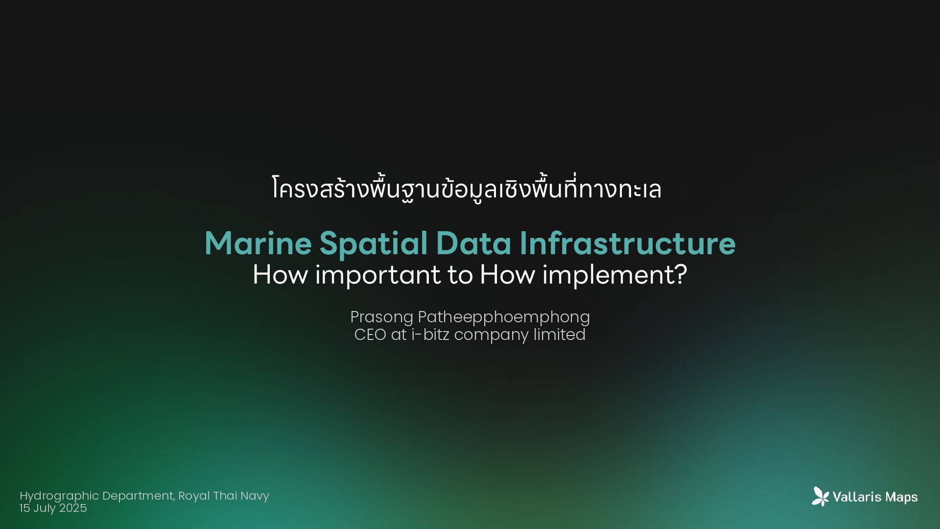
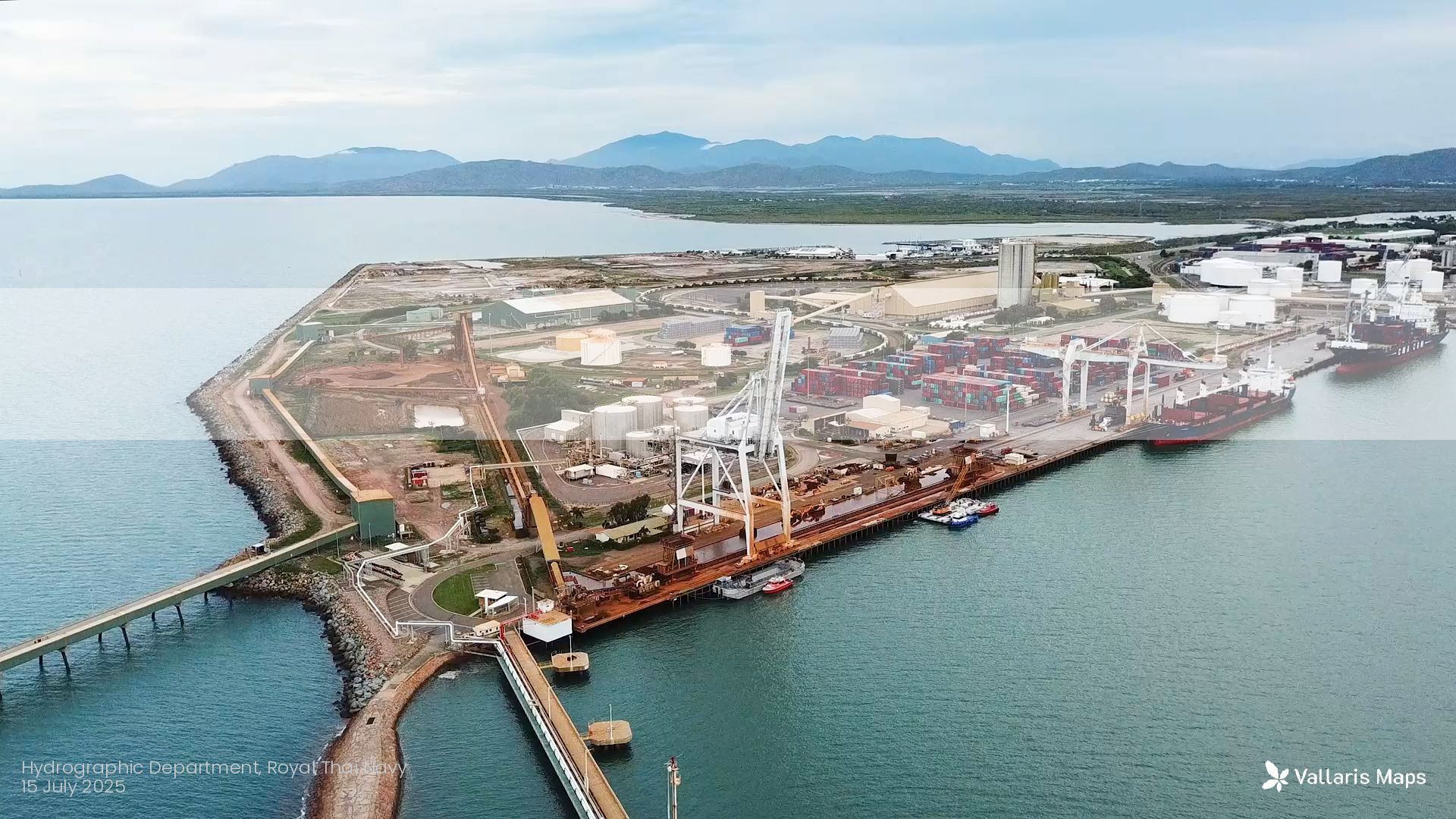
Patheepphoemphong CEO at i-bitz company limited Hydrographic Department, Royal Thai Navy 15 July 2025 โครงสร้าง พื ้ นฐานข้อมูลเชิง พื ้ น ที ่ ทางทะเล
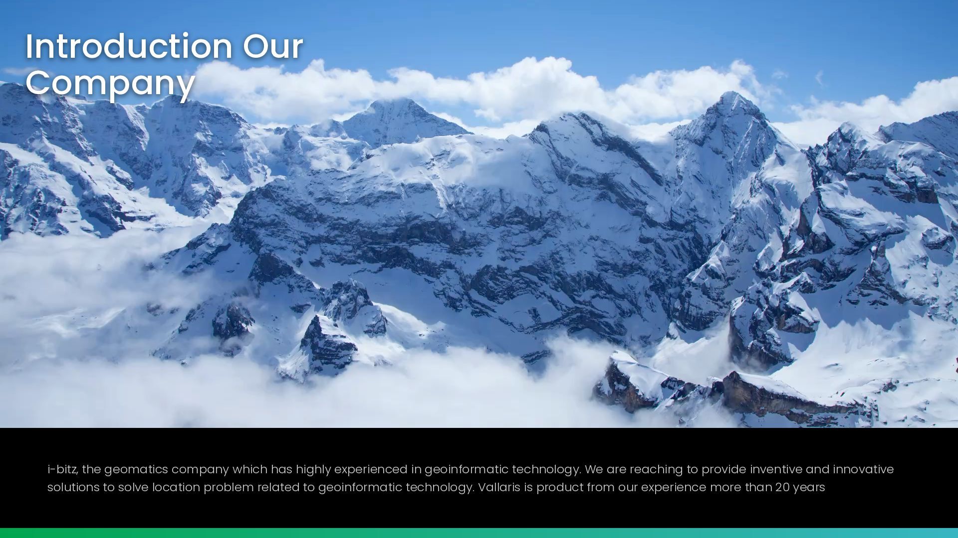
experienced in geoinformatic technology. We are reaching to provide inventive and innovative solutions to solve location problem related to geoinformatic technology. Vallaris is product from our experience more than 20 years
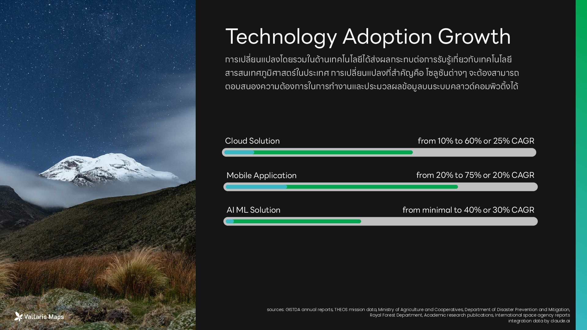
ยนแปลง ที่ ส ำ คัญคือ โซลูชันต่างๆ จะต้องสามารถ ตอบสนองความต้องการในการท ำ งานและประมวลผลข้อมูลบนระบบคลาวด์คอมพิว ต ิ ้ งได้ Technology Adoption Growth from 10% to 60% or 25% CAGR Cloud Solution Mobile Application AI ML Solution from 20% to 75% or 20% CAGR from minimal to 40% or 30% CAGR sources: GISTDA annual reports, THEOS mission data, Ministry of Agriculture and Cooperatives, Department of Disaster Prevention and Mitigation, Royal Forest Department, Academic research publications, International space agency reports integration data by claude.ai
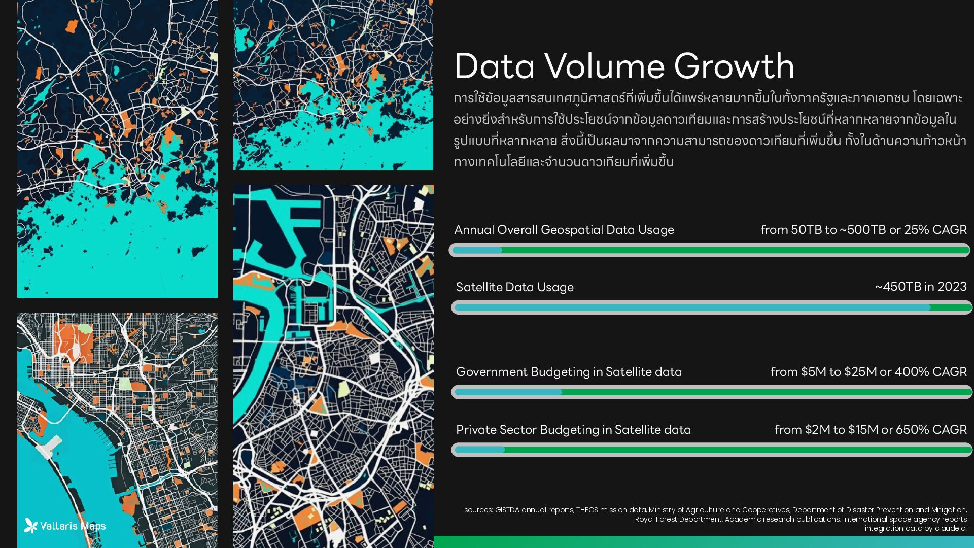
ขึ ้ นใน ท ั ้ งภาครัฐและภาคเอกชน โดยเฉพาะ อย่าง ย ิ ่ งส ำ หรับการใช้ประโยชน์จากข้อมูลดาวเทียมและการสร้างประโยชน์ ที ่ หลากหลายจากข้อมูลใน รูปแบบ ที่ หลากหลาย ส ิ ่ ง นี ้ เ ป็ นผลมาจากความสามารถของดาวเทียม ที ่ เ พ ิ ่ ม ขึ ้ น ท ั ้ งในด้านความก้าวหน้า ทางเทคโนโลยีและจ ำ นวนดาวเทียม ที ่ เ พ ิ ่ ม ขึ้ น Data Volume Growth from 50TB to ~500TB or 25% CAGR Annual Overall Geospatial Data Usage Satellite Data Usage ~450TB in 2023 sources: GISTDA annual reports, THEOS mission data, Ministry of Agriculture and Cooperatives, Department of Disaster Prevention and Mitigation, Royal Forest Department, Academic research publications, International space agency reports integration data by claude.ai Government Budgeting in Satellite data from $5M to $25M or 400% CAGR Private Sector Budgeting in Satellite data from $2M to $15M or 650% CAGR
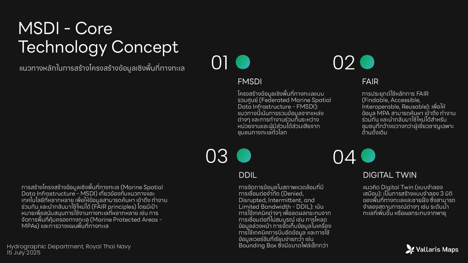
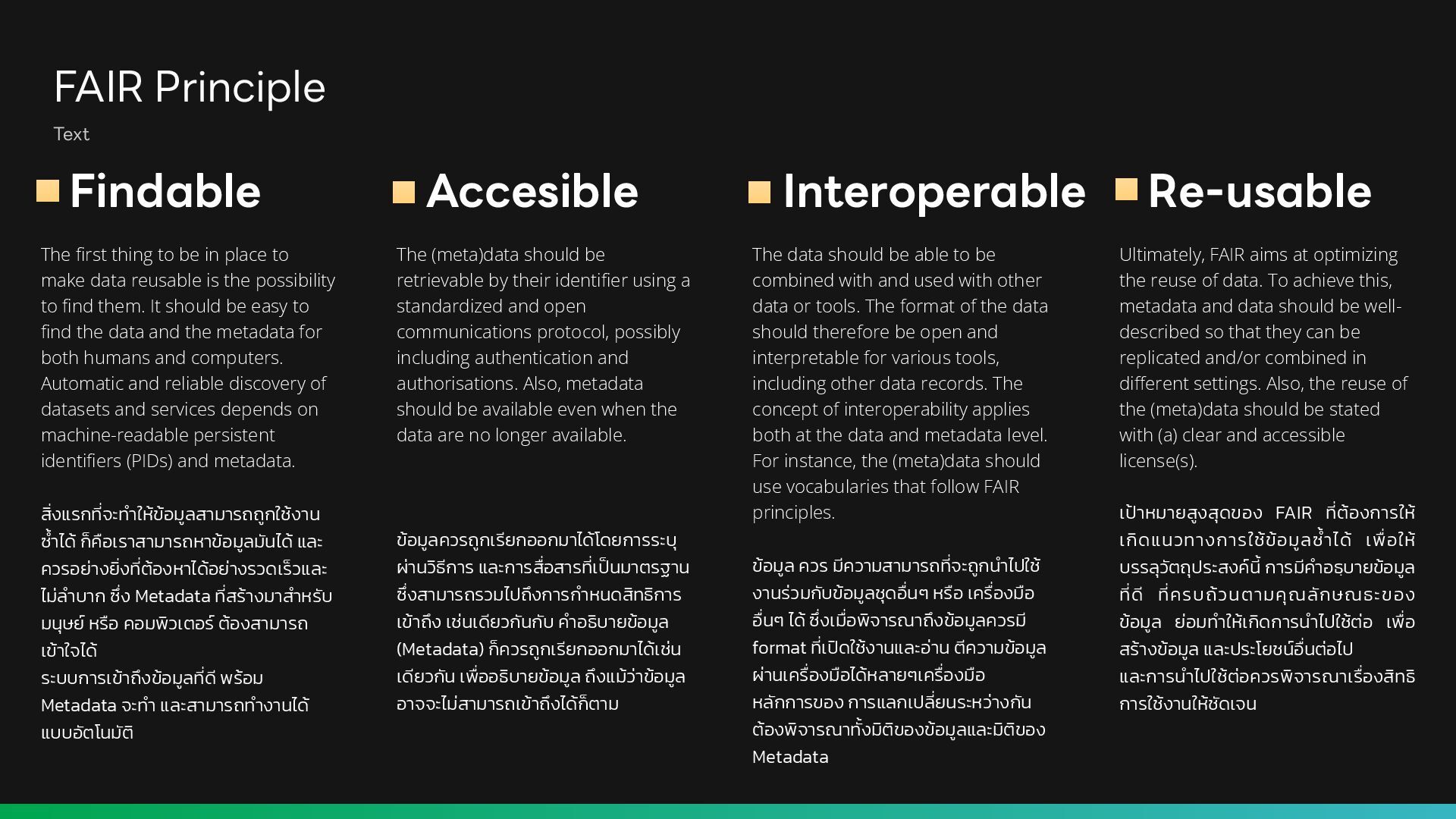
place to make data reusable is the possibility to fi nd them. It should be easy to fi nd the data and the metadata for both humans and computers. Automatic and reliable discovery of datasets and services depends on machine-readable persistent identi fi ers (PIDs) and metadata. ส ิ ่ งแรก ที่ จะท ำ ให้ข้อมูลสามารถถูกใช้งาน ซ ้ ำ ได้ ก็คือเราสามารถหาข้อมูลมันได้ และ ควรอย่าง ย ิ ่ ง ที่ ต้องหาได้อย่างรวดเร็วและ ไม่ล ำ บาก ซึ ่ ง Metadata ที่ สร้างมาส ำ หรับ มนุษย์ หรือ คอมพิวเตอร์ ต้องสามารถ เข้าใจได้ ระบบการเข้าถึงข้อมูล ที่ ดี พร้อม Metadata จะท ำ และสามารถท ำ งานได้ แบบอัตโนมัติ Findable The (meta)data should be retrievable by their identi fi er using a standardized and open communications protocol, possibly including authentication and authorisations. Also, metadata should be available even when the data are no longer available. ข้อมูลควรถูกเรียกออกมาได้โดยการระบุ ผ่านวิธีการ และการ สื ่ อสาร ที ่ เ ป็ นมาตรฐาน ซึ่ งสามารถรวมไปถึงการก ำ หนดสิทธิการ เข้าถึง เช่นเดียวกันกับ ค ำ อธิบายข้อมูล (Metadata) ก็ควรถูกเรียกออกมาได้เช่น เดียวกัน เ พื ่ ออธิบายข้อมูล ถึงแม้ว่าข้อมูล อาจจะไม่สามารถเข้าถึงได้ก็ตาม The data should be able to be combined with and used with other data or tools. The format of the data should therefore be open and interpretable for various tools, including other data records. The concept of interoperability applies both at the data and metadata level. For instance, the (meta)data should use vocabularies that follow FAIR principles. ข้อมูล ควร มีความสามารถ ที่ จะถูกน ำ ไปใช้ งานร่วมกับข้อมูลชุด อื ่ นๆ หรือ เค รื ่ องมือ อื่ นๆ ได้ ซึ ่ งเ มื่ อพิจารณาถึงข้อมูลควรมี format ที่ เ ปิ ดใช้งานและอ่าน ตีความข้อมูล ผ่านเค รื ่ องมือได้หลายๆเค รื ่ องมือ หลักการของ การแลกเป ลี ่ ยนระหว่างกัน ต้องพิจารณา ทั ้ งมิติของข้อมูลและมิติของ Metadata Ultimately, FAIR aims at optimizing the reuse of data. To achieve this, metadata and data should be well- described so that they can be replicated and/or combined in di ff erent settings. Also, the reuse of the (meta)data should be stated with (a) clear and accessible license(s). เ ป้ าหมายสูงสุดของ FAIR ที ่ ต้องการให้ เกิดแนวทางการใช้ข้อมูล ซ ้ ำ ได้ เ พื ่ อให้ บรรลุวัตถุประสงค์ นี้ การมีค ำ อธฺบายข้อมูล ที่ ดี ที่ ครบถ้วนตามคุณลักษณธะของ ข้อมูล ย่อมท ำ ให้เกิดการน ำ ไปใช้ต่อ เ พื ่ อ สร้างข้อมูล และประโยชน์ อื ่ นต่อไป และการน ำ ไปใช้ต่อควรพิจารณาเ รื ่ องสิทธิ การใช้งานให้ชัดเจน Interoperable Accesible Re-usable
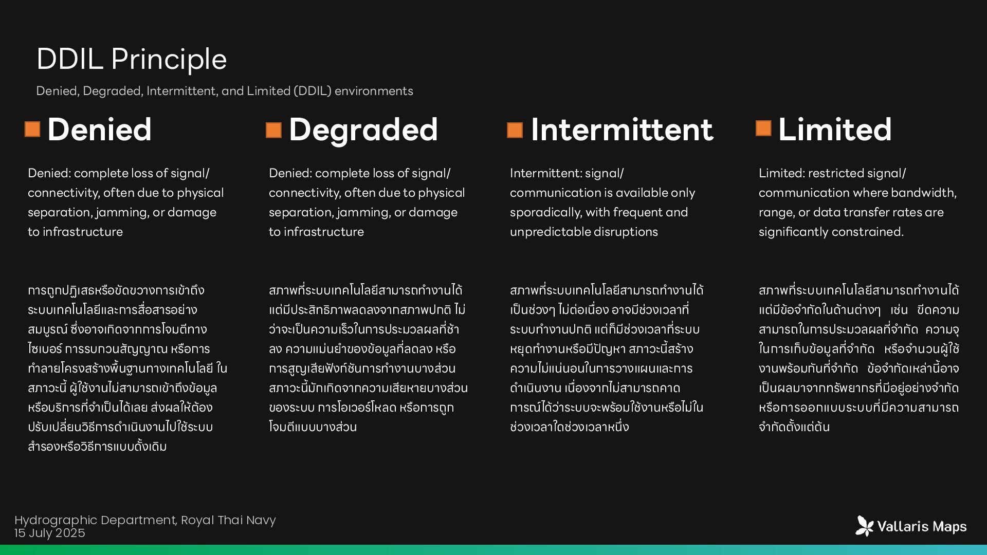
transfer rates are significantly constrained Unpredictable access data or system Denied Communication System or data may can not access or damage Degraded Intermittent Limited Communication complete loss of signal/connectivity
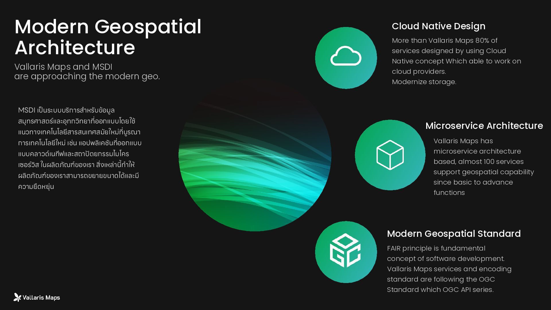
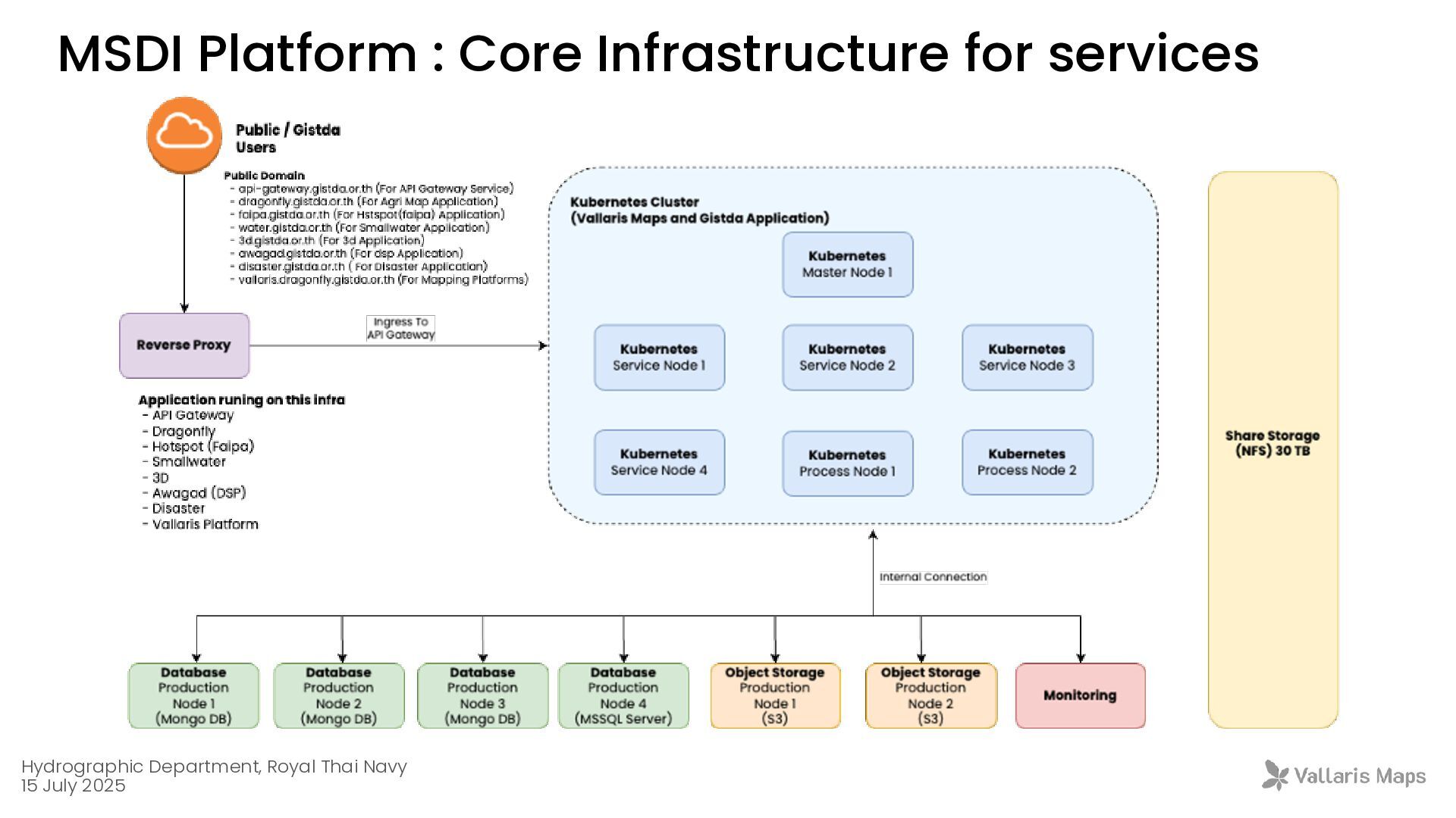
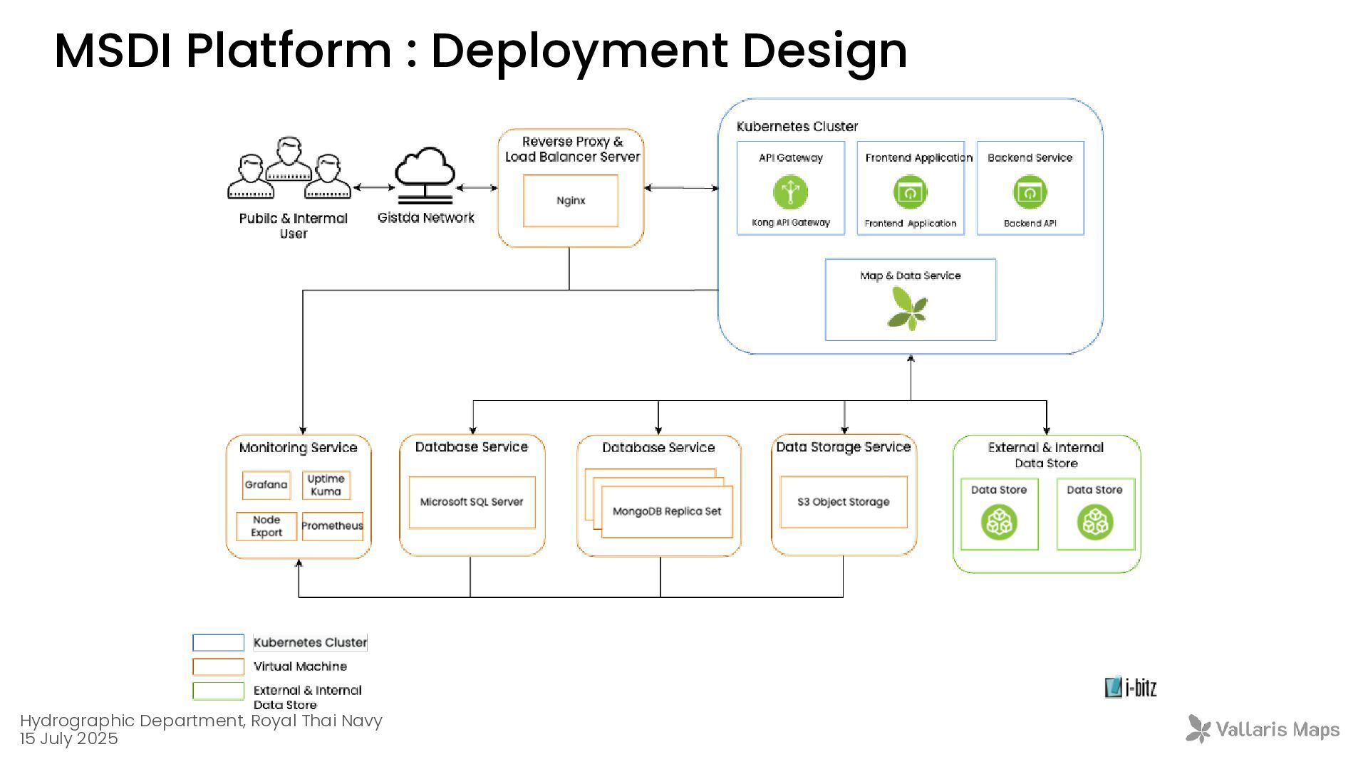
services support geospatial capability since basic to advance functions Modern Geospatial Standard FAIR principle is fundamental concept of software development. Vallaris Maps services and encoding standard are following the OGC Standard which OGC API series. Cloud Native Design More than Vallaris Maps 80% of services designed by using Cloud Native concept Which able to work on cloud providers. Modernize storage. MSDI เ ป็ นระบบบริการส ำ หรับข้อมูล สมุทรศาสตร์และอุทกวิทยา ที่ ออกแบบโดยใช้ แนวทางเทคโนโลยีสารสนเทศสมัยใหม่ ที ่ บูรณา การเทคโนโลยีใหม่ เช่น แอปพลิเคชัน ที ่ ออกแบบ แบบคลาวด์เนทีฟและสถา ปั ตยกรรมไมโคร เซอร์วิส ในผลิตภัณฑ์ของเรา ส ิ ่ งเหล่า นี ้ ท ำ ให้ ผลิตภัณฑ์ของเราสามารถขยายขนาดได้และมี ความยืดหยุ่น Modern Geospatial Architecture Vallaris Maps and MSDI are approaching the modern geo.
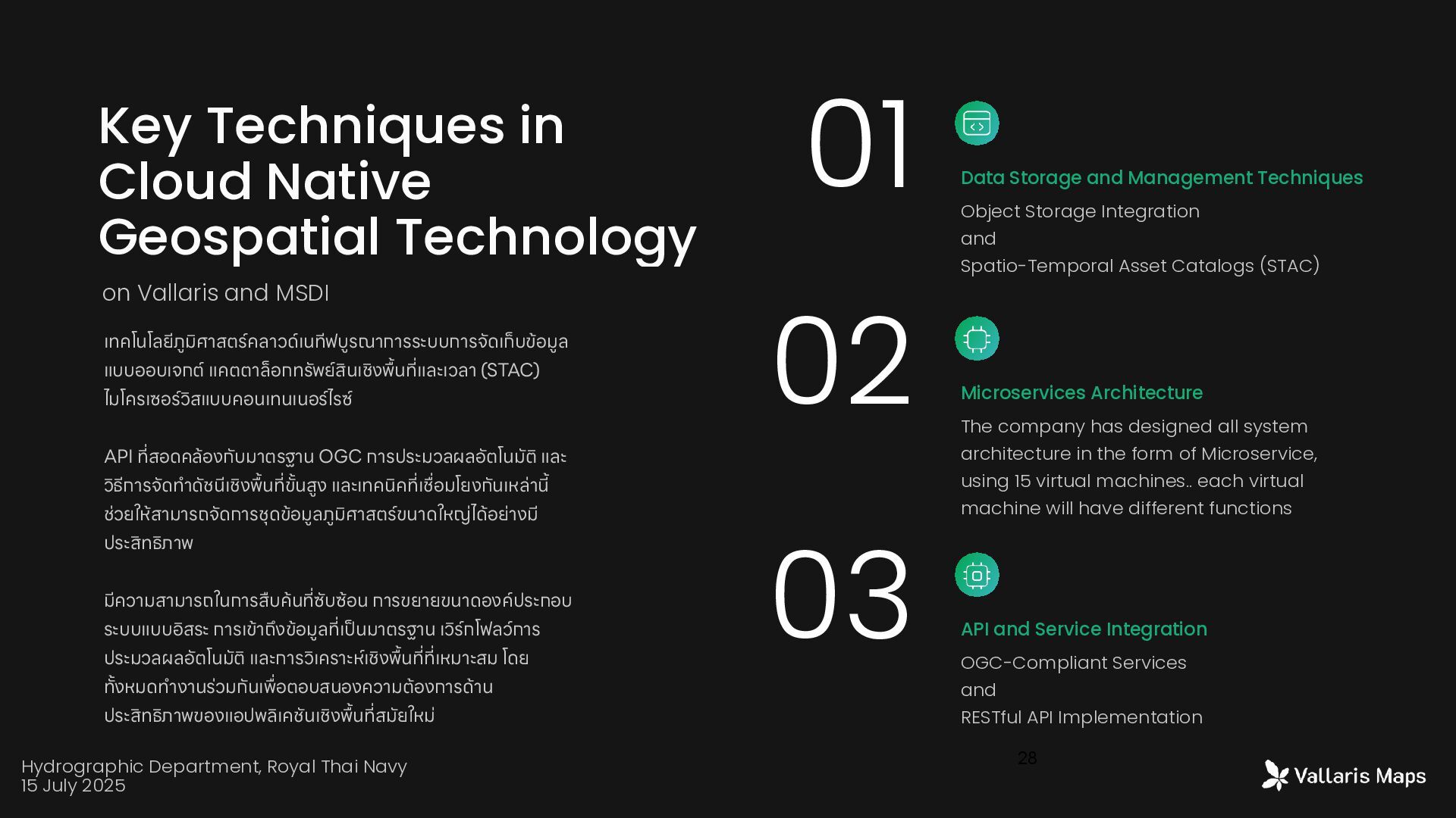
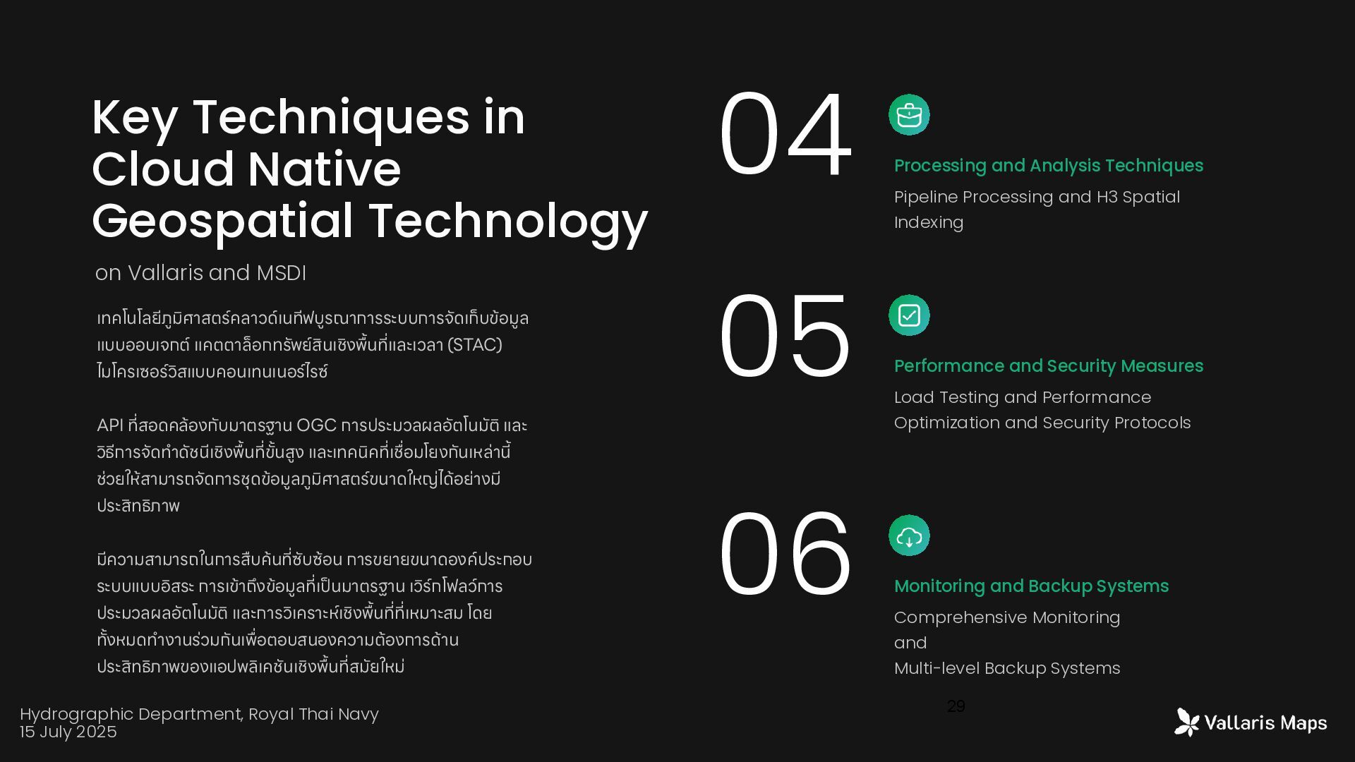
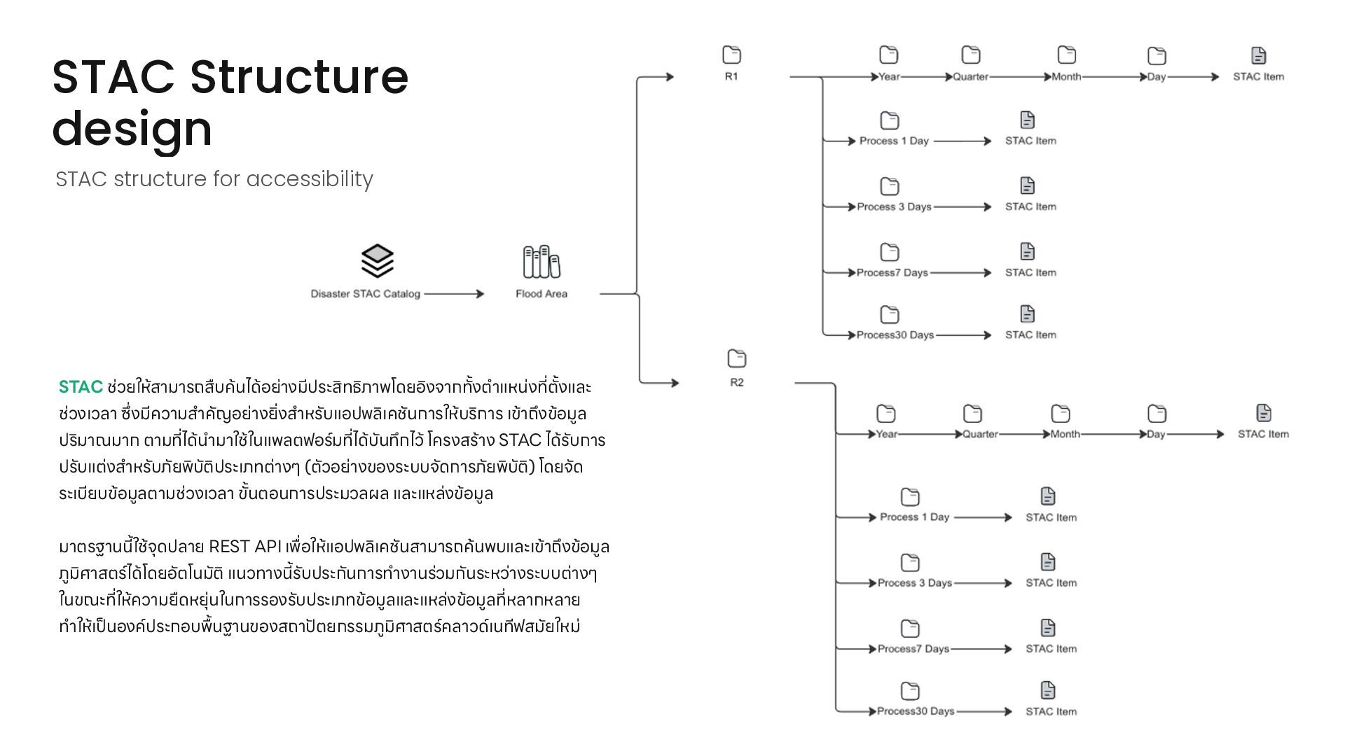
Technology Data Storage and Management Techniques Object Storage Integration and Spatio-Temporal Asset Catalogs (STAC) Microservices Architecture The company has designed all system architecture in the form of Microservice, using 15 virtual machines.. each virtual machine will have different functions API and Service Integration OGC-Compliant Services and RESTful API Implementation on Vallaris and MSDI เทคโนโลยีภูมิศาสตร์คลาวด์เนทีฟบูรณาการระบบการจัดเก็บข้อมูล แบบออบเจกต์ แคตตาล็อกทรัพย์สินเชิง พื ้ น ที ่ และเวลา (STAC) ไมโครเซอร์วิสแบบคอนเทนเนอร์ไรซ์ API ที ่ สอดคล้องกับมาตรฐาน OGC การประมวลผลอัตโนมัติ และ วิธีการจัดท ำ ดัชนีเชิง พื้ น ที ่ ข ั ้ นสูง และเทคนิค ที ่ เ ชื่ อมโยงกันเหล่า นี ้ ช่วยให้สามารถจัดการชุดข้อมูลภูมิศาสตร์ขนาดใหญ่ได้อย่างมี ประสิทธิภาพ มีความสามารถในการสืบค้น ที ่ ซับซ้อน การขยายขนาดองค์ประกอบ ระบบแบบอิสระ การเข้าถึงข้อมูล ที ่ เ ป็ นมาตรฐาน เวิร์กโฟลว์การ ประมวลผลอัตโนมัติ และการวิเคราะห์เชิง พื ้ น ที ่ ที ่ เหมาะสม โดย ท ั ้ งหมดท ำ งานร่วมกันเ พื่ อตอบสนองความต้องการด้าน ประสิทธิภาพของแอปพลิเคชันเชิง พื ้ น ที ่ สมัยใหม่ Hydrographic Department, Royal Thai Navy 15 July 2025
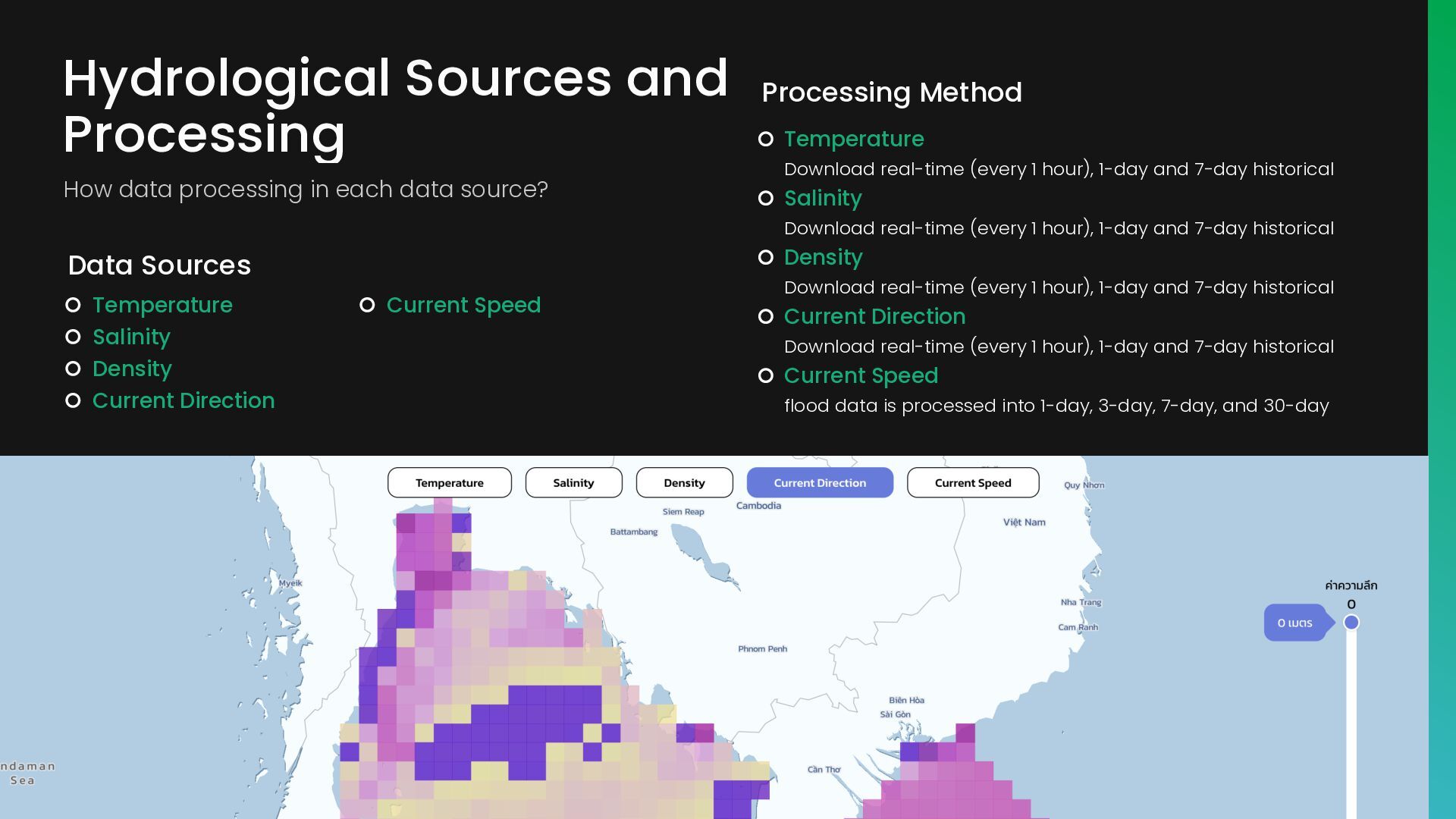
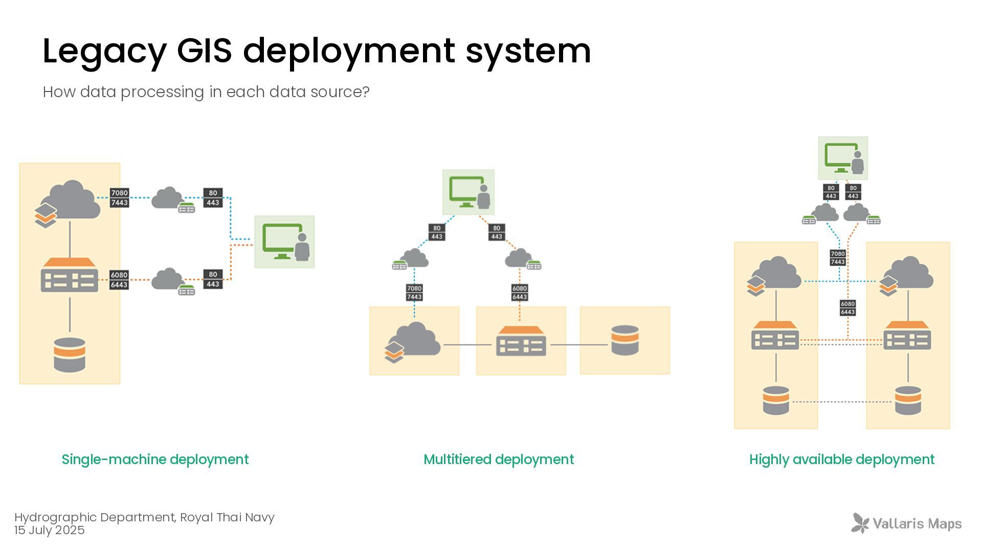
source? Temperature Salinity Density Current Direction Temperature Download real-time (every 1 hour), 1-day and 7-day historical Salinity Download real-time (every 1 hour), 1-day and 7-day historical Density Download real-time (every 1 hour), 1-day and 7-day historical Current Direction Download real-time (every 1 hour), 1-day and 7-day historical Current Speed flood data is processed into 1-day, 3-day, 7-day, and 30-day Data Sources Processing Method Current Speed
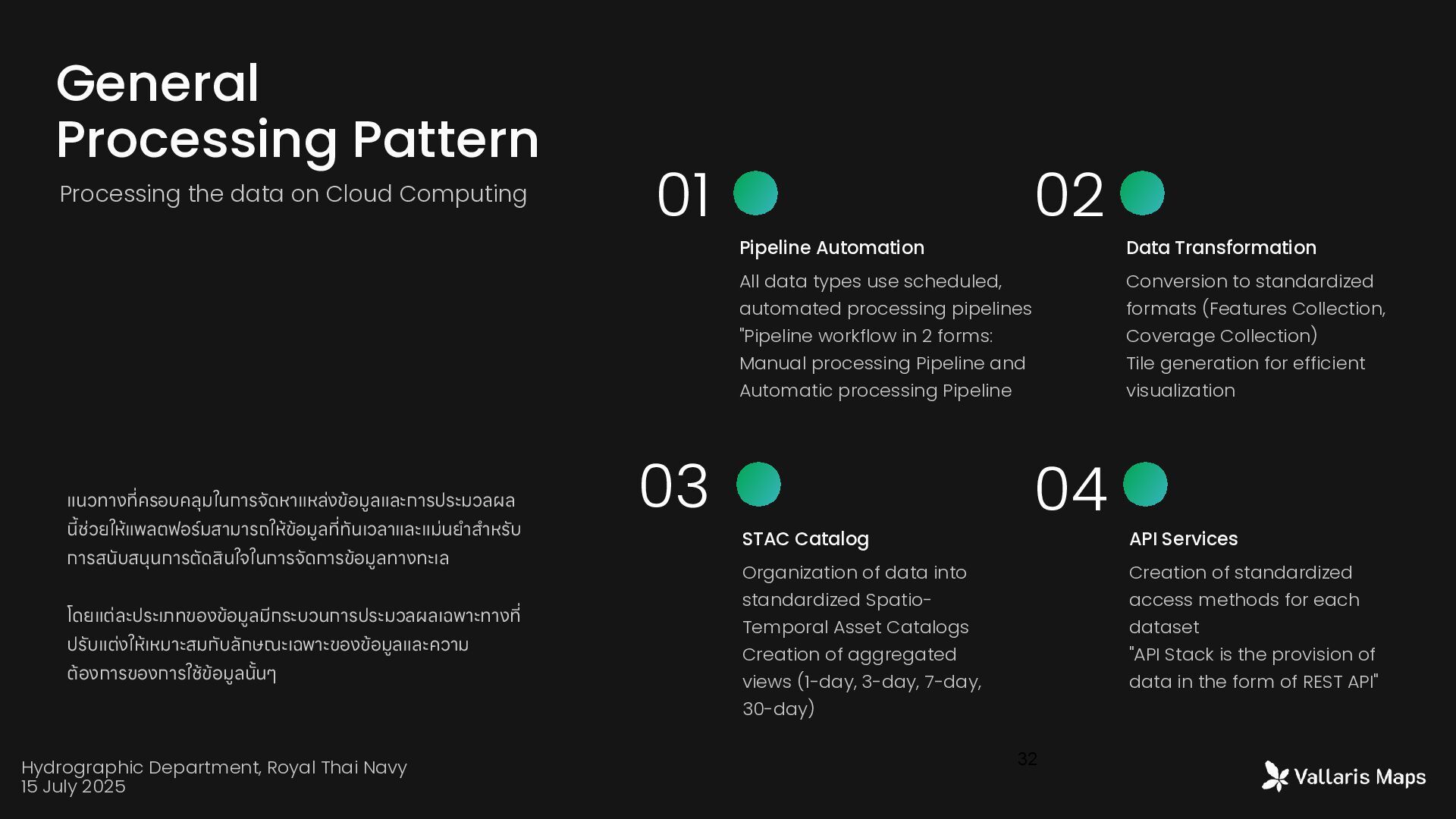
data on Cloud Computing Pipeline Automation All data types use scheduled, automated processing pipelines "Pipeline workflow in 2 forms: Manual processing Pipeline and Automatic processing Pipeline Data Transformation Conversion to standardized formats (Features Collection, Coverage Collection) Tile generation for efficient visualization STAC Catalog Organization of data into standardized Spatio- Temporal Asset Catalogs Creation of aggregated views (1-day, 3-day, 7-day, 30-day) API Services Creation of standardized access methods for each dataset "API Stack is the provision of data in the form of REST API" แนวทาง ที ่ ครอบคลุมในการจัดหาแหล่งข้อมูลและการประมวลผล นี้ ช่วยให้แพลตฟอร์มสามารถให้ข้อมูล ที ่ ทันเวลาและแม่นย ำ ส ำ หรับ การสนับสนุนการตัดสินใจในการจัดการข้อมูลทางทะเล โดยแต่ละประเภทของข้อมูลมีกระบวนการประมวลผลเฉพาะทาง ที ่ ปรับแต่งให้เหมาะสมกับลักษณะเฉพาะของข้อมูลและความ ต้องการของการใช้ข้อมูล น ั ้ นๆ Hydrographic Department, Royal Thai Navy 15 July 2025
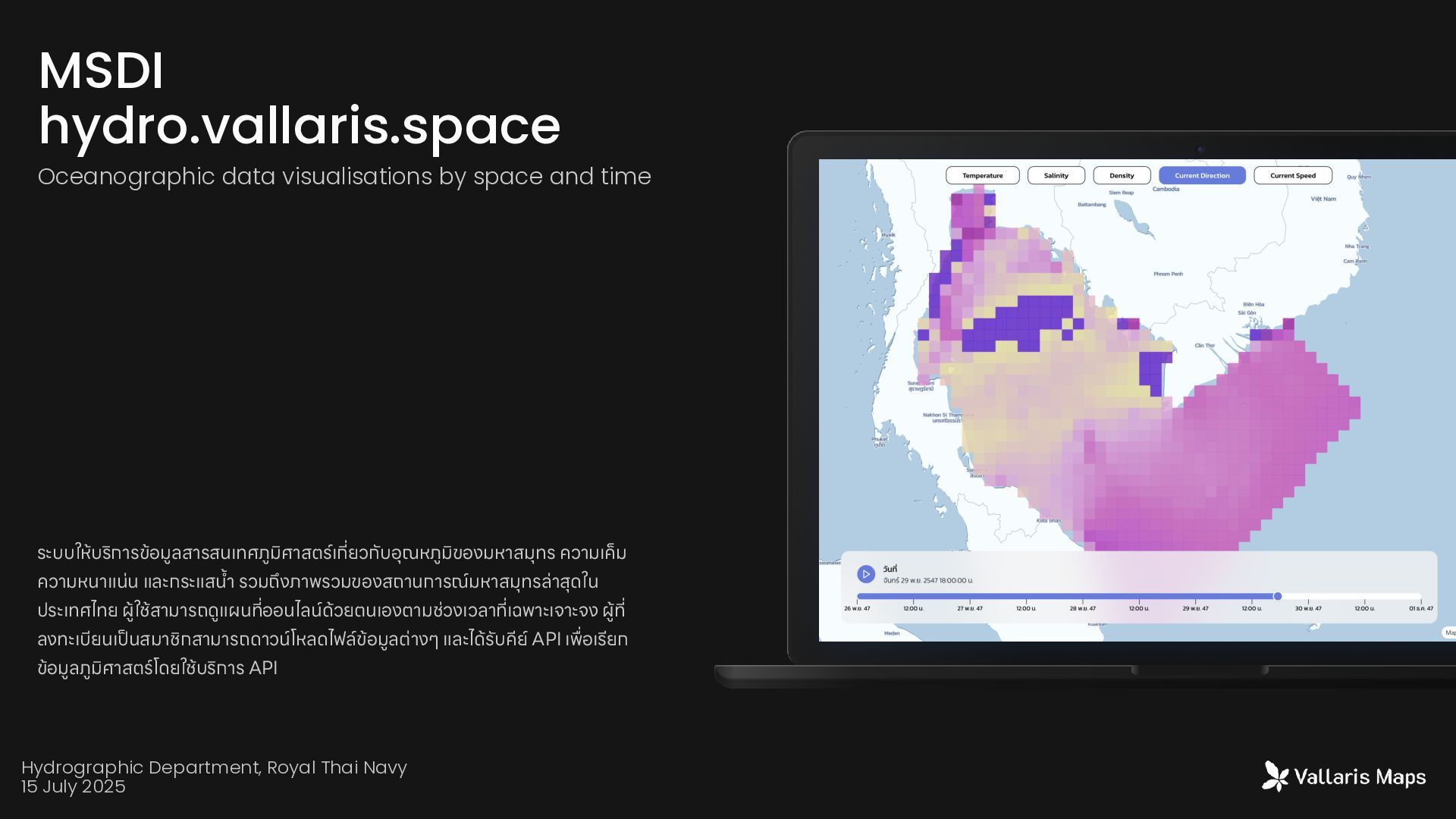
ประเทศไทย ผู ้ ใช้สามารถดูแผน ที ่ ออนไลน์ด้วยตนเองตามช่วงเวลา ที ่ เฉพาะเจาะจง ผู้ ที ่ ลงทะเบียนเ ป็ นสมาชิกสามารถดาว น์ โหลดไฟล์ข้อมูลต่างๆ และได้รับคีย์ API เ พื่ อเรียก ข้อมูลภูมิศาสต ร์ โดยใช้บริการ API MSDI hydro.vallaris.space Oceanographic data visualisations by space and time Hydrographic Department, Royal Thai Navy 15 July 2025
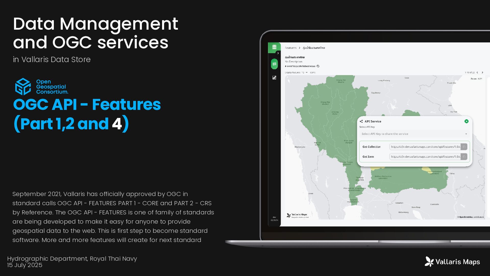
calls OGC API - FEATURES PART 1 - CORE and PART 2 - CRS by Reference. The OGC API - FEATURES is one of family of standards are being developed to make it easy for anyone to provide geospatial data to the web. This is first step to become standard software. More and more features will create for next standard Data Management and OGC services in Vallaris Data Store OGC API - Features (Part 1,2 and 4) Hydrographic Department, Royal Thai Navy 15 July 2025
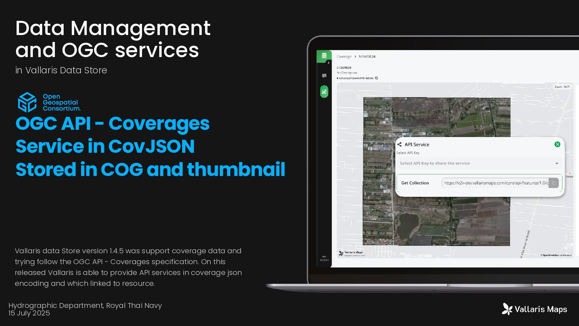
trying follow the OGC API - Coverages specification. On this released Vallaris is able to provide API services in coverage json encoding and which linked to resource. Data Management and OGC services in Vallaris Data Store OGC API - Coverages Service in CovJSON Stored in COG and thumbnail Hydrographic Department, Royal Thai Navy 15 July 2025
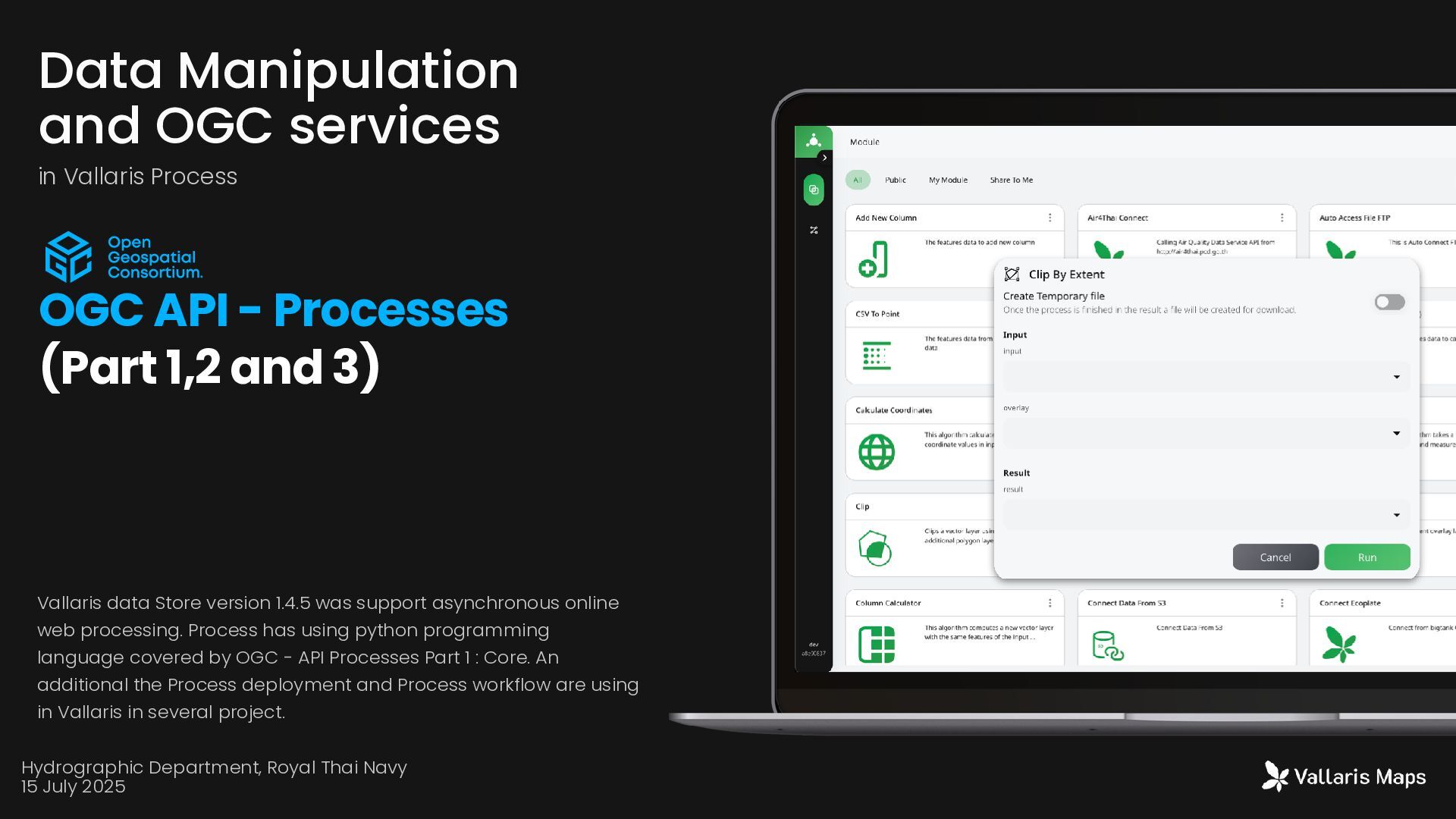
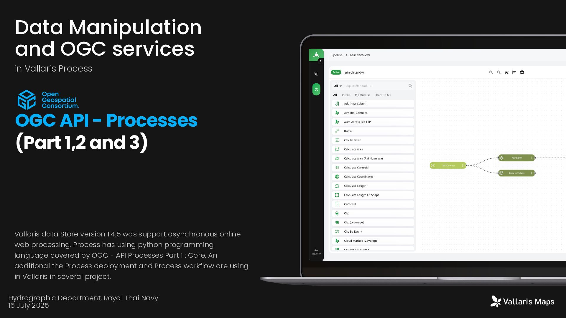
processing. Process has using python programming language covered by OGC - API Processes Part 1 : Core. An additional the Process deployment and Process workflow are using in Vallaris in several project. Data Manipulation and OGC services in Vallaris Process OGC API - Processes (Part 1,2 and 3) Hydrographic Department, Royal Thai Navy 15 July 2025
- Processes (Part 1,2 and 3) Vallaris data Store version 1.4.5 was support asynchronous online web processing. Process has using python programming language covered by OGC - API Processes Part 1 : Core. An additional the Process deployment and Process workflow are using in Vallaris in several project. Hydrographic Department, Royal Thai Navy 15 July 2025
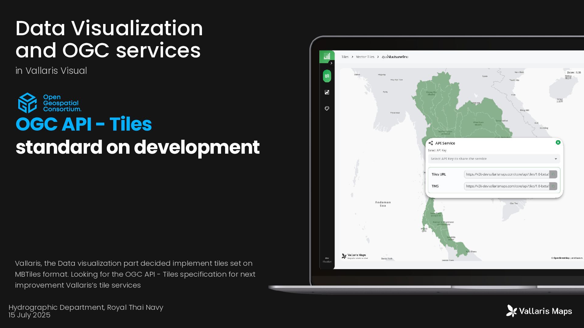
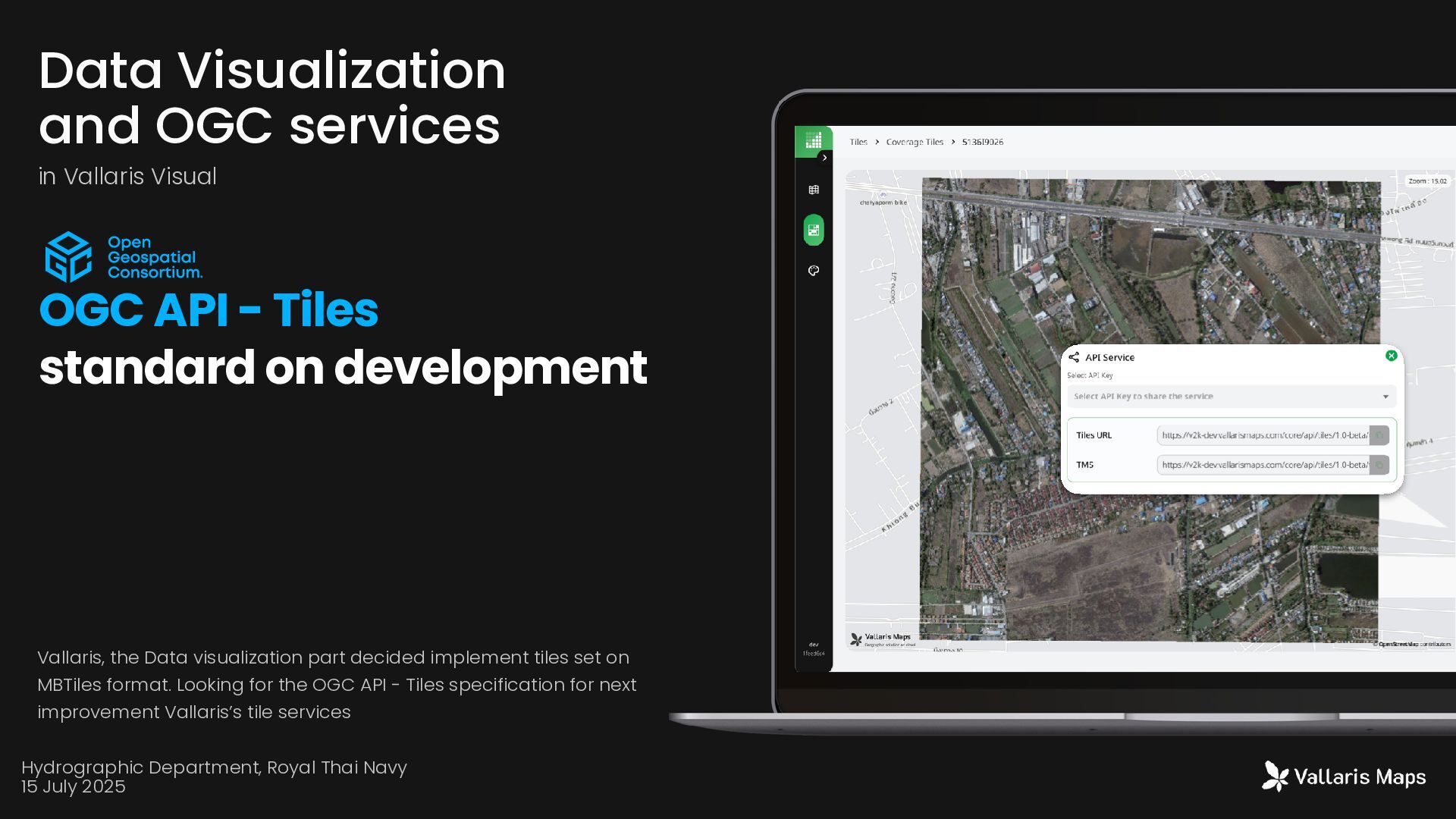
MBTiles format. Looking for the OGC API - Tiles specification for next improvement Vallaris’s tile services Data Visualization and OGC services in Vallaris Visual OGC API - Tiles standard on development Hydrographic Department, Royal Thai Navy 15 July 2025
- Tiles standard on development Vallaris, the Data visualization part decided implement tiles set on MBTiles format. Looking for the OGC API - Tiles specification for next improvement Vallaris’s tile services Hydrographic Department, Royal Thai Navy 15 July 2025
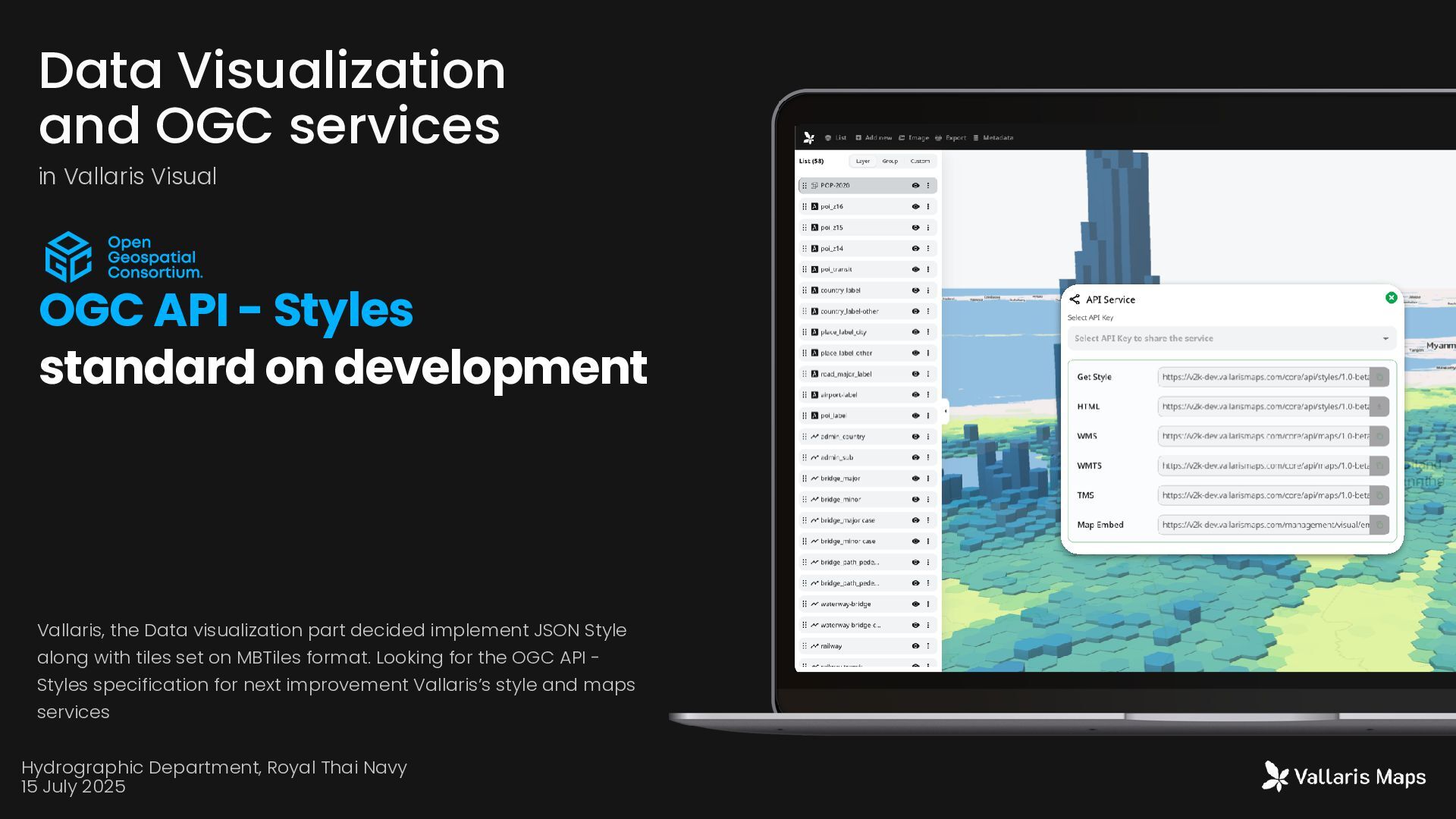
- Styles standard on development Vallaris, the Data visualization part decided implement JSON Style along with tiles set on MBTiles format. Looking for the OGC API - Styles specification for next improvement Vallaris’s style and maps services Hydrographic Department, Royal Thai Navy 15 July 2025
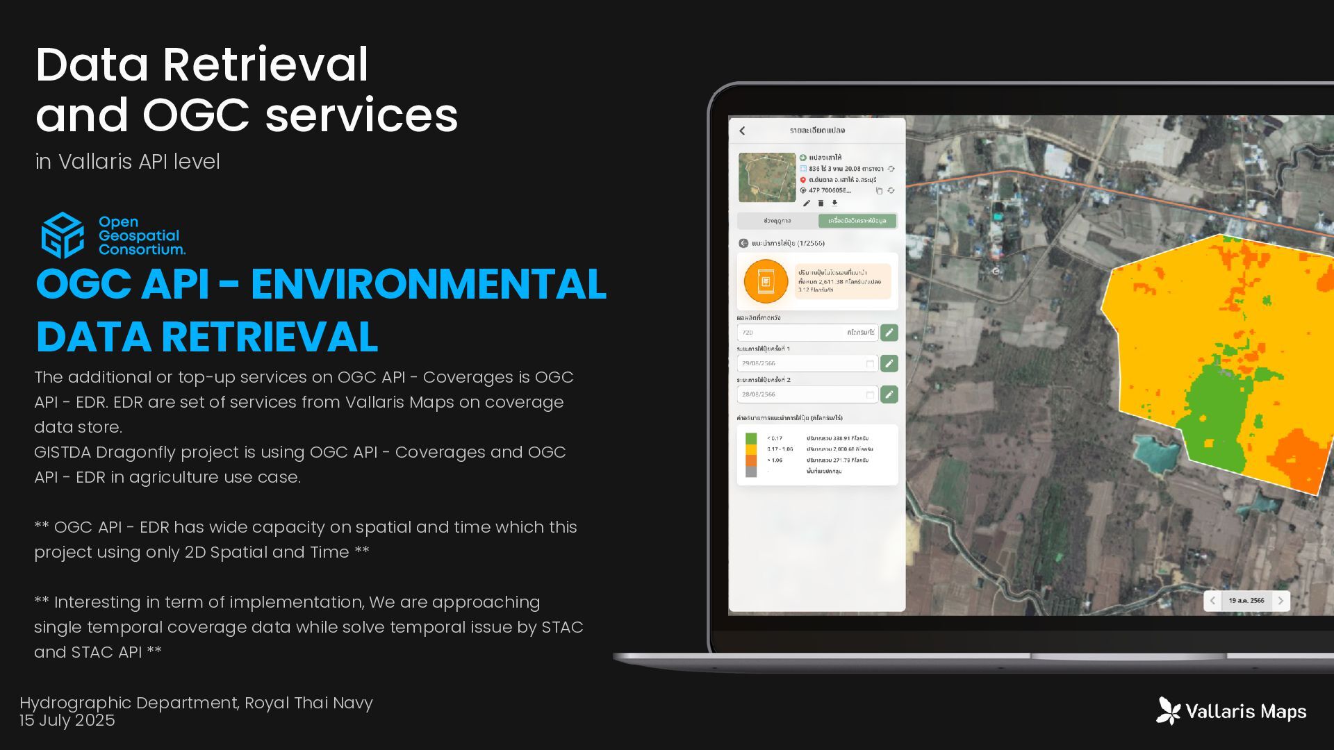
is OGC API - EDR. EDR are set of services from Vallaris Maps on coverage data store. GISTDA Dragonfly project is using OGC API - Coverages and OGC API - EDR in agriculture use case. ** OGC API - EDR has wide capacity on spatial and time which this project using only 2D Spatial and Time ** ** Interesting in term of implementation, We are approaching single temporal coverage data while solve temporal issue by STAC and STAC API ** Data Retrieval and OGC services in Vallaris API level OGC API - ENVIRONMENTAL DATA RETRIEVAL Hydrographic Department, Royal Thai Navy 15 July 2025
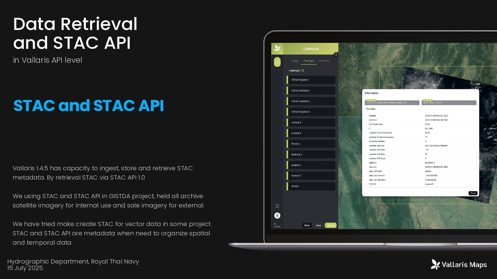
metadata. By retrieval STAC via STAC API 1.0 We using STAC and STAC API in GISTDA project, held all archive satellite imagery for internal use and sale imagery for external. We have tried make create STAC for vector data in some project. STAC and STAC API are metadata when need to organize spatial and temporal data. Data Retrieval and STAC API in Vallaris API level STAC and STAC API Hydrographic Department, Royal Thai Navy 15 July 2025
any time on (phone cell) or contact us by (email). We will get back to you as soon as we can Location 1371 Suite10 Capital Mansion Phahonyothin Rd Phayathai Bangkok 10400 Office Hours Monday-Friday 09.00-17.00 Get In Touch (+66) 2278 7913 (+66) 186666 4624 More Information vallarismaps.com [email protected] Contact Us Company