Upgrade to Pro
— share decks privately, control downloads, hide ads and more …
Speaker Deck
Features
Speaker Deck
PRO
Sign in
Sign up for free
Search
Search
空間情報システム入門Ⅰ
Search
ittoku
June 16, 2016
Education
79
0
Share
Embed
Copy iframe code
Copy JS code
Copy link
Start on current slide
空間情報システム入門Ⅰ
ittoku
June 16, 2016
More Decks by ittoku
See All by ittoku
overpass-turbの使用方法
1108otsuka
0
44
空間情報システム入門Ⅰ
1108otsuka
0
63
Other Decks in Education
See All in Education
Estimating Group × Time Interaction in Scale-Transformed CEFR-J Self-Assessment Scores: A Case in Study-Abroad Research
uranoken
0
100
0506
cbtlibrary
0
200
Human-AI Interaction - Lecture 11 - Next Generation User Interfaces (4018166FNR)
signer
PRO
0
1.1k
「機械学習と因果推論」入門 ② 回帰分析から因果分析へ
masakat0
0
710
Catecismo 26 #1 - Aula inaugural
cm_manaus
0
180
2026年度春学期 統計学 第6回 データの関係を知る(1)ー 相関関係 (2026. 5. 14)
akiraasano
PRO
0
130
解決策を教えても次期リーダーは育たない ─ 器の発達に伴走するために / Partnering with leaders in their vertical development
matsu0228
1
420
SL AMIGOS 教育格差と私たちの取り組み - スリランカの支援学校への支援プロジェクト:リシンドゥ リオ 氏 (別府溝部学園短期大学 ビジネス観光コース 留学生):2720 Japan O.K. ロータリーEクラブ2026年4月6日卓話
2720japanoke
0
630
✅ レポート採点基準 / How Your Reports Are Assessed
yasslab
PRO
0
370
焦燥を平穏に変えるエンジニアのための哲学
ichimichi
3
3.5k
Visionary Initiative: Future Intelligence 「未来の知性と社会の礎を築く」|Science Tokyo(東京科学大学)
sciencetokyo
PRO
0
440
[2026前期火5] 論理学(京都大学文学部 前期 第5回)「 ならばの問題演習・proof net・かつの規則」
yatabe
0
300
Featured
See All Featured
The Mindset for Success: Future Career Progression
greggifford
PRO
0
360
ラッコキーワード サービス紹介資料
rakko
1
3.7M
The Illustrated Guide to Node.js - THAT Conference 2024
reverentgeek
1
390
Discover your Explorer Soul
emna__ayadi
2
1.1k
Exploring the Power of Turbo Streams & Action Cable | RailsConf2023
kevinliebholz
37
6.5k
First, design no harm
axbom
PRO
2
1.2k
Learning to Love Humans: Emotional Interface Design
aarron
275
41k
Digital Projects Gone Horribly Wrong (And the UX Pros Who Still Save the Day) - Dean Schuster
uxyall
1
1.8k
Skip the Path - Find Your Career Trail
mkilby
1
150
Designing Powerful Visuals for Engaging Learning
tmiket
1
420
Connecting the Dots Between Site Speed, User Experience & Your Business [WebExpo 2025]
tammyeverts
11
950
Effective software design: The role of men in debugging patriarchy in IT @ Voxxed Days AMS
baasie
0
430
Transcript
OpenStreetMapマニュアル No.1A116046 Name.大塚 一徳
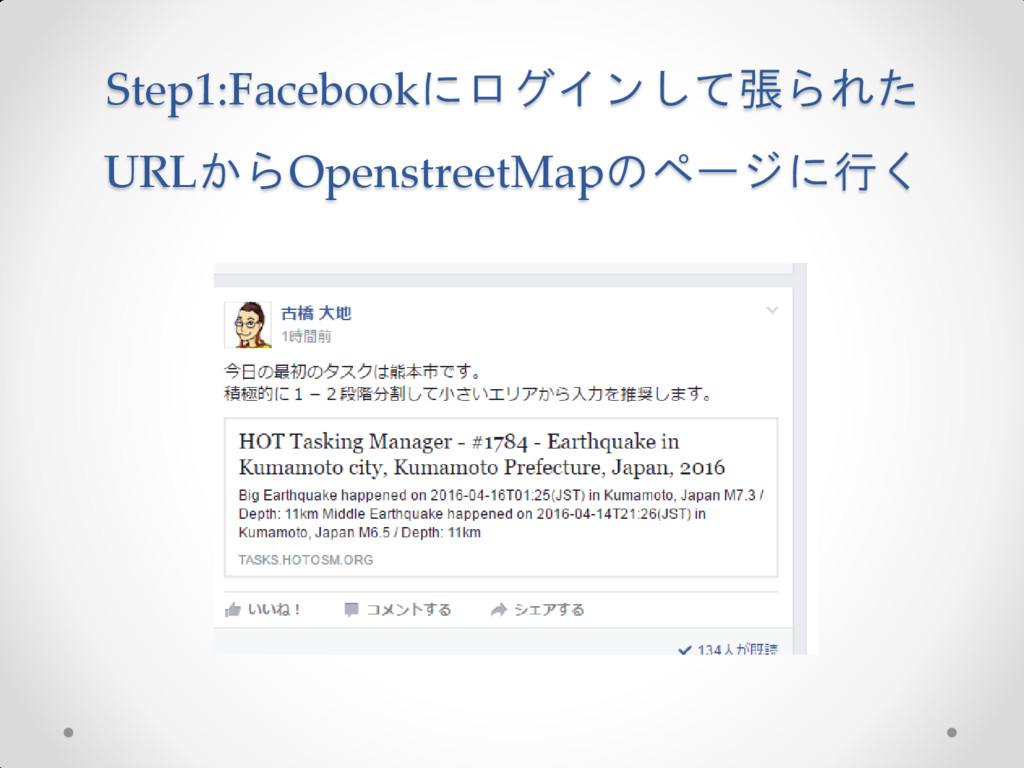
Step1:Facebookにログインして張られた URLからOpenstreetMapのページに行く
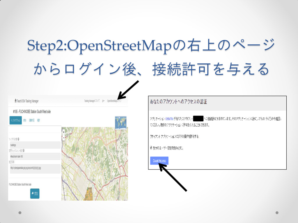
Step2:OpenStreetMapの右上のページ からログイン後、接続許可を与える
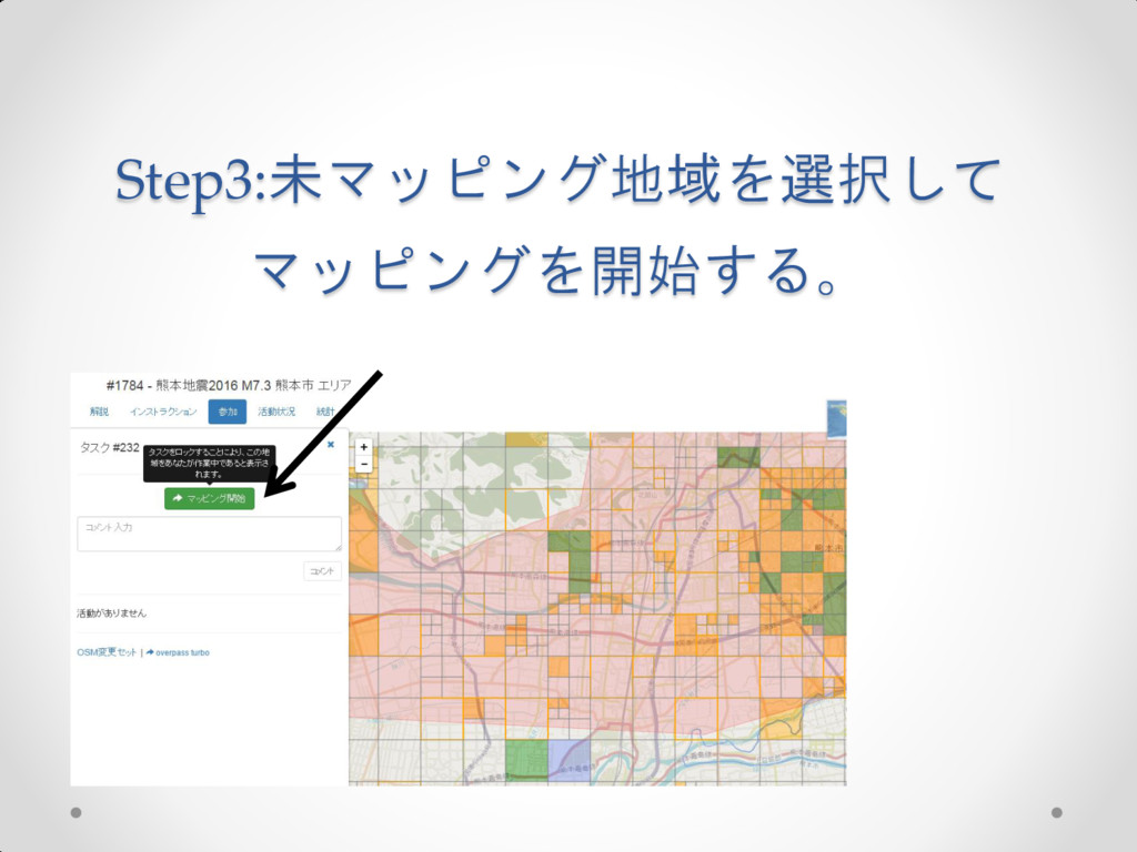
Step3:未マッピング地域を選択して マッピングを開始する。
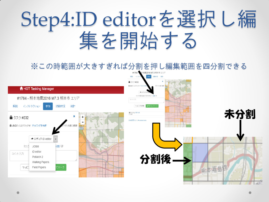
Step4:ID editorを選択し編 集を開始する ※この時範囲が大きすぎれば分割を押し編集範囲を四分割できる 分割後 未分割
Step5:背景地図をJapan GSI ortho Imagery(国土地理院のもの)に変更 クリック
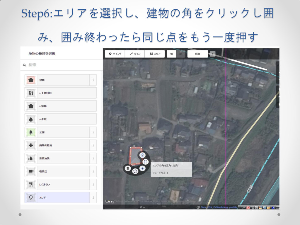
Step6:エリアを選択し、建物の角をクリックし囲 み、囲み終わったら同じ点をもう一度押す
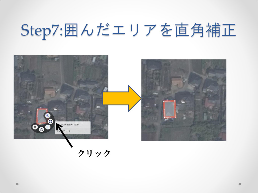
Step7:囲んだエリアを直角補正 クリック
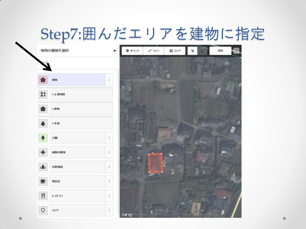
Step7:囲んだエリアを建物に指定
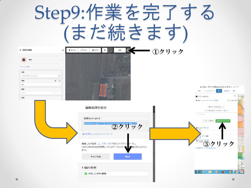
Step9:作業を完了する (まだ続きます) ①クリック ②クリック ③クリック
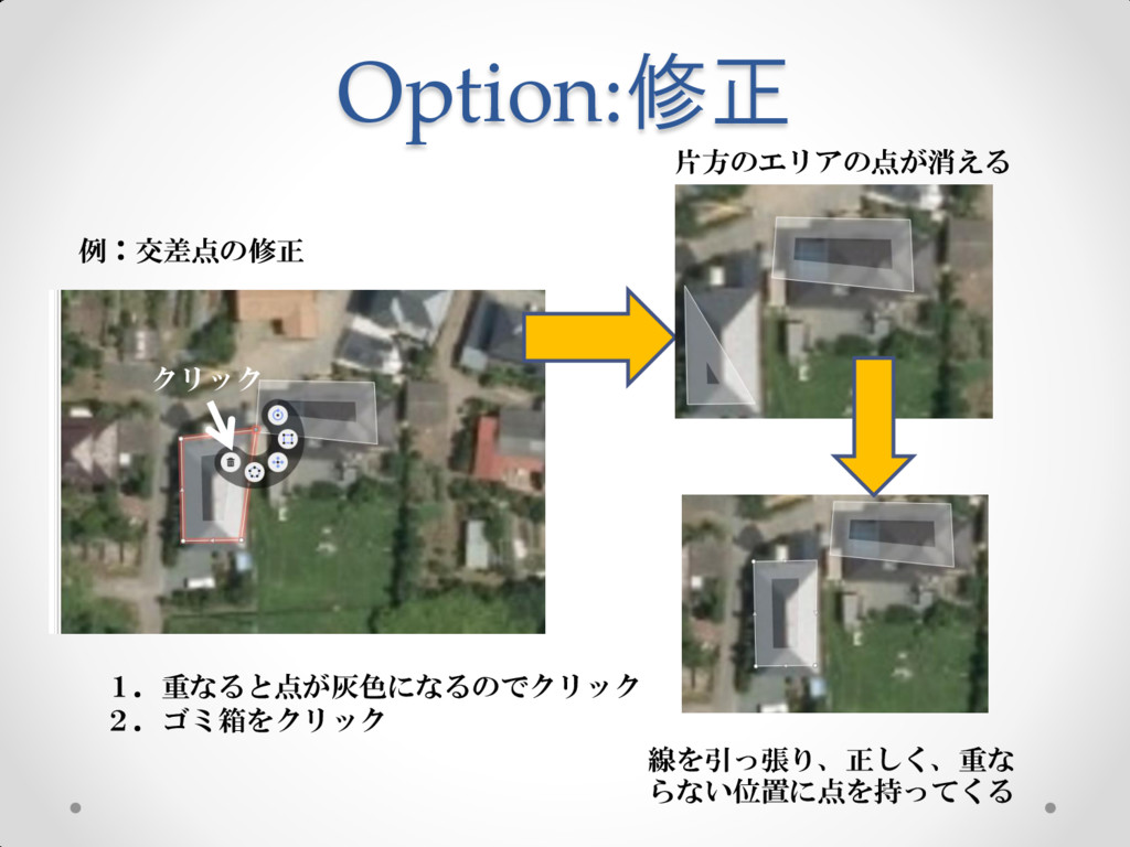
Option:修正 例:交差点の修正 1.重なると点が灰色になるのでクリック 2.ゴミ箱をクリック クリック 片方のエリアの点が消える 線を引っ張り、正しく、重な らない位置に点を持ってくる