Upgrade to Pro
— share decks privately, control downloads, hide ads and more …
Speaker Deck
Features
Speaker Deck
PRO
Sign in
Sign up for free
Search
Search
空間情報システム入門Ⅰ
Search
Sponsored
·
Your Podcast. Everywhere. Effortlessly.
Share. Educate. Inspire. Entertain. You do you. We'll handle the rest.
→
ittoku
June 16, 2016
Education
63
0
Share
Embed
Copy iframe code
Copy JS code
Copy link
Start on current slide
空間情報システム入門Ⅰ
ittoku
June 16, 2016
More Decks by ittoku
See All by ittoku
overpass-turbの使用方法
1108otsuka
0
43
空間情報システム入門Ⅰ
1108otsuka
0
79
Other Decks in Education
See All in Education
2026年度春学期 統計学 第2回 統計資料の収集と読み方 (2026. 4. 16)
akiraasano
PRO
0
180
プロポーザルを書く技術とアンチパターン/proposal-writing-and-antipatterns
moriyuya
13
3.4k
2026年度春学期 統計学 第1回 イントロダクション ー 統計的なものの見方・考え方について (2026. 4. 9)
akiraasano
PRO
0
160
Curso de Consagração ao Sagrado Coração de Jesus - O Sagrado Coração na História (Aula 01)
cm_manaus
0
220
コミュニティを通じた_キャリア設計のススメ_20260424.pdf
masakiokuda
0
320
「機械学習と因果推論」入門 ⑤ 因果効果推定の一般化
masakat0
0
110
Course Review - Lecture 13 - Next Generation User Interfaces (4018166FNR)
signer
PRO
0
2.3k
JAWS-UG初心者支部#81 GWにEduJAWSと何か作ろうもくもく会!
otsuki
0
130
Lectura 1 (PIT : Python Basico)
robintux
0
360
2026年度春学期 統計学 第3回 クロス集計と感度・特異度,データの可視化 (2026. 4. 23)
akiraasano
PRO
0
150
!コスパよくインターンに受かる方法!
ruribou
1
270
[2026前期火5] 論理学(京都大学文学部 前期 第3回)「形式言語と四つのキーワード:メタ・構成・意味論・ハーモニー」
yatabe
0
550
Featured
See All Featured
Self-Hosted WebAssembly Runtime for Runtime-Neutral Checkpoint/Restore in Edge–Cloud Continuum
chikuwait
0
590
B2B Lead Gen: Tactics, Traps & Triumph
marketingsoph
0
150
Building a Scalable Design System with Sketch
lauravandoore
463
34k
Navigating Weather and Climate Data
rabernat
0
220
Mobile First: as difficult as doing things right
swwweet
225
10k
Understanding Cognitive Biases in Performance Measurement
bluesmoon
32
2.9k
Amusing Abliteration
ianozsvald
1
210
The Myth of the Modular Monolith - Day 2 Keynote - Rails World 2024
eileencodes
28
3.5k
StorybookのUI Testing Handbookを読んだ
zakiyama
31
6.8k
Darren the Foodie - Storyboard
khoart
PRO
3
3.4k
My Coaching Mixtape
mlcsv
0
150
The untapped power of vector embeddings
frankvandijk
2
1.8k
Transcript
OpenStreetMapマニュアル No.1A116046 Name.大塚 一徳
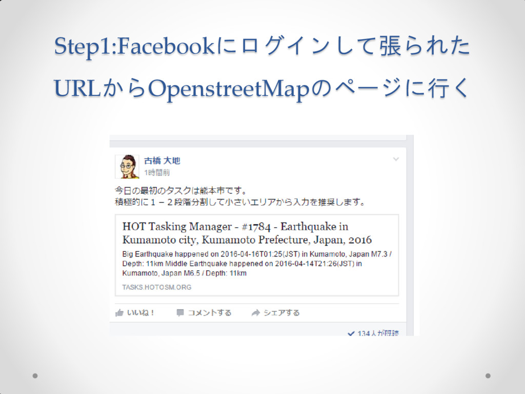
Step1:Facebookにログインして張られた URLからOpenstreetMapのページに行く
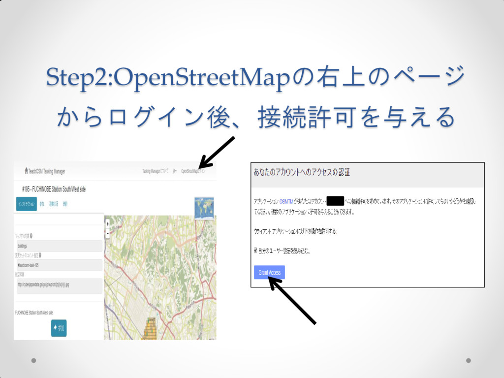
Step2:OpenStreetMapの右上のページ からログイン後、接続許可を与える
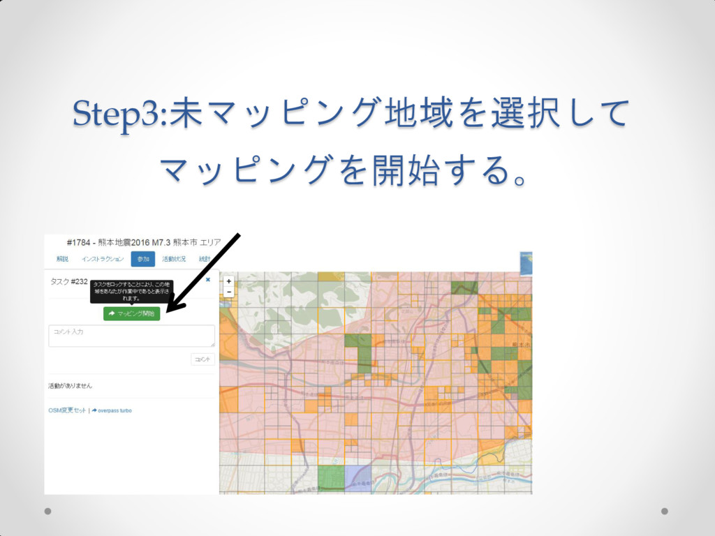
Step3:未マッピング地域を選択して マッピングを開始する。
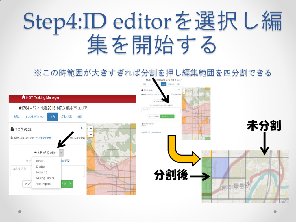
Step4:ID editorを選択し編 集を開始する ※この時範囲が大きすぎれば分割を押し編集範囲を四分割できる 分割後 未分割
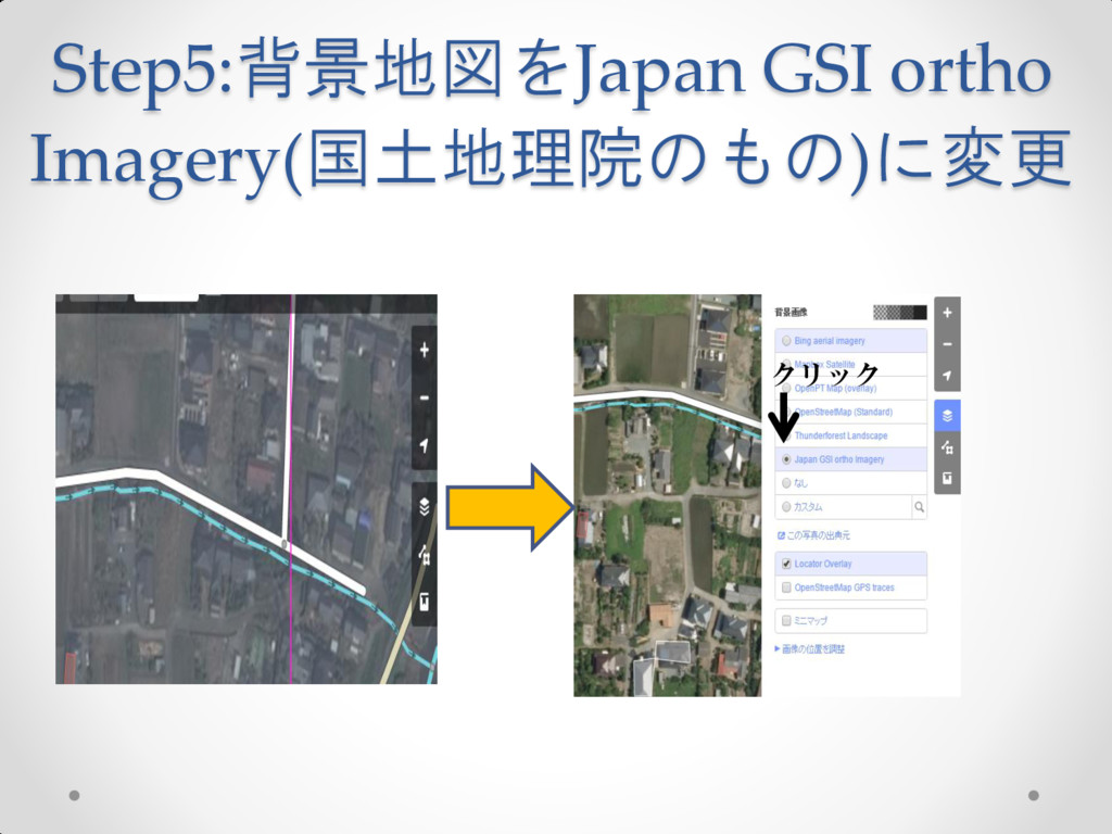
Step5:背景地図をJapan GSI ortho Imagery(国土地理院のもの)に変更 クリック
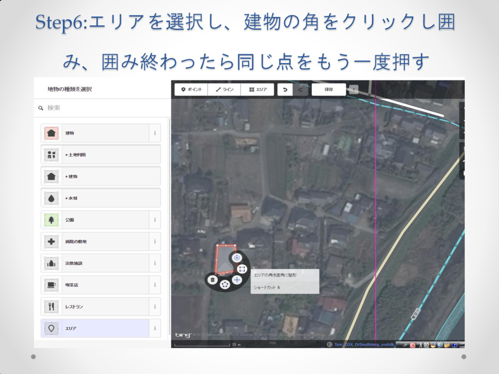
Step6:エリアを選択し、建物の角をクリックし囲 み、囲み終わったら同じ点をもう一度押す
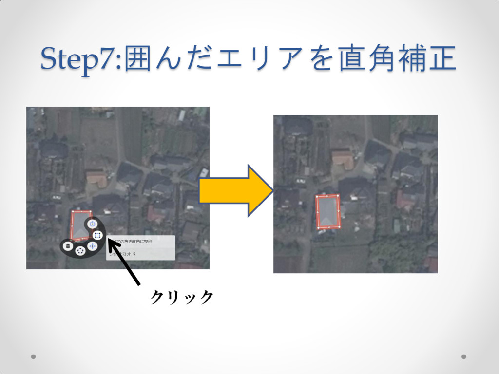
Step7:囲んだエリアを直角補正 クリック
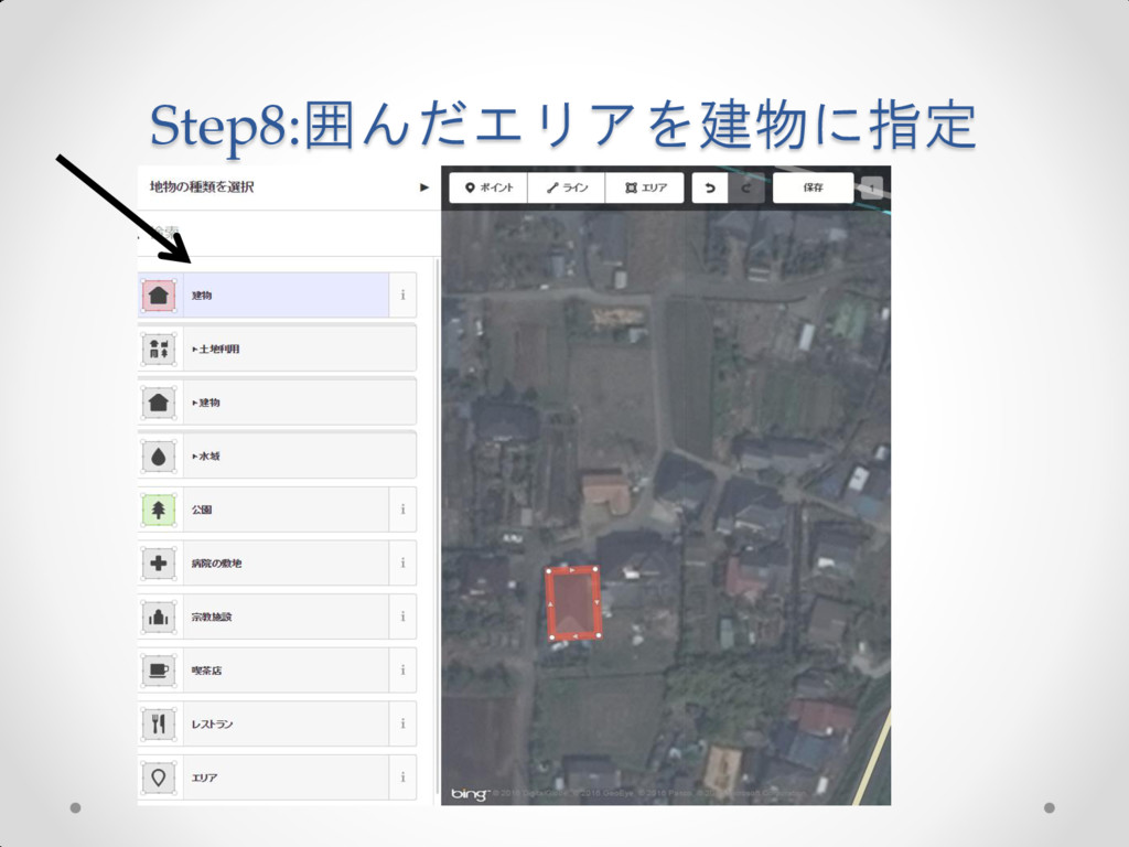
Step8:囲んだエリアを建物に指定
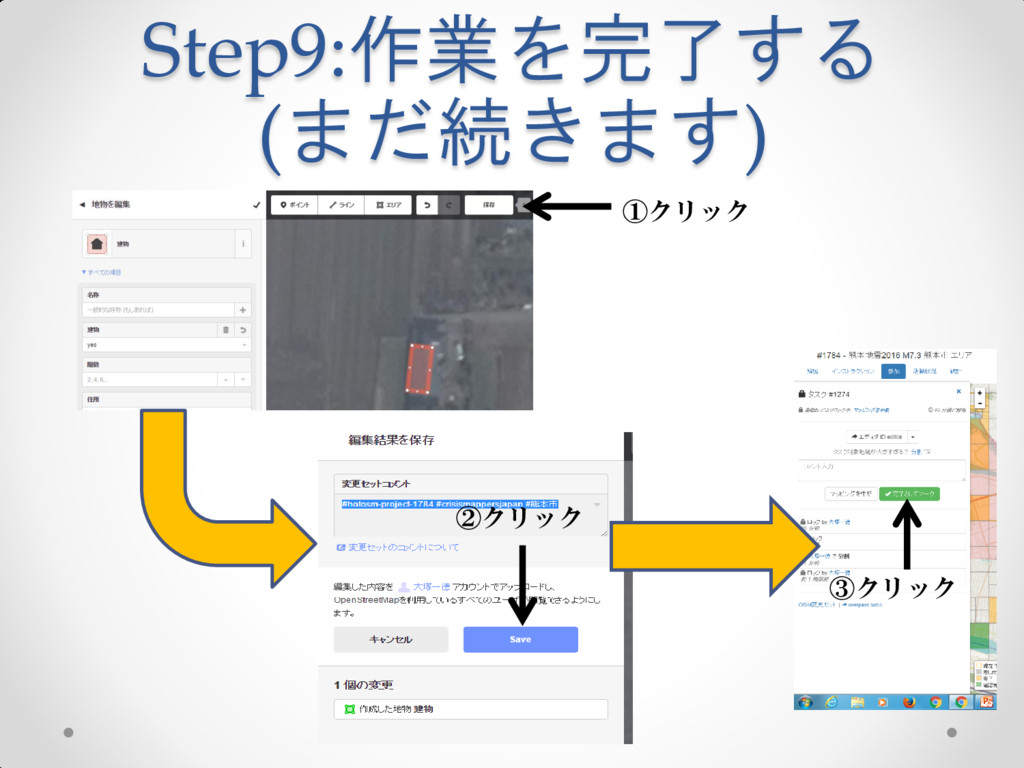
Step9:作業を完了する (まだ続きます) ①クリック ②クリック ③クリック
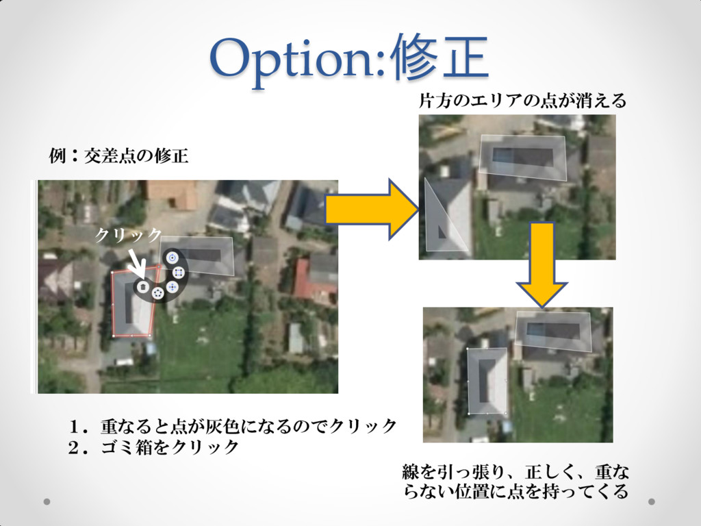
Option:修正 例:交差点の修正 1.重なると点が灰色になるのでクリック 2.ゴミ箱をクリック クリック 片方のエリアの点が消える 線を引っ張り、正しく、重な らない位置に点を持ってくる