di Barat Daya Laut Jawa Dosen pembimbing: Prof. Dr.rer.nat. Poerbandono Gabriella Alodia, Ph.D. Dr.techn. Dudy Darmawan Wijaya Moch. Agung P. Wibowo Adhima Al Azmy Daiva Nadine Pratiwi Atha Helmizahran Shafa Nur Hafidzah (15121038) (15121048) (15121056) (15121058) (15121086) Program Studi Sarjana Teknik Geodesi dan Geomatika Fakultas Ilmu dan Teknologi Kebumian Institut Teknologi Bandung
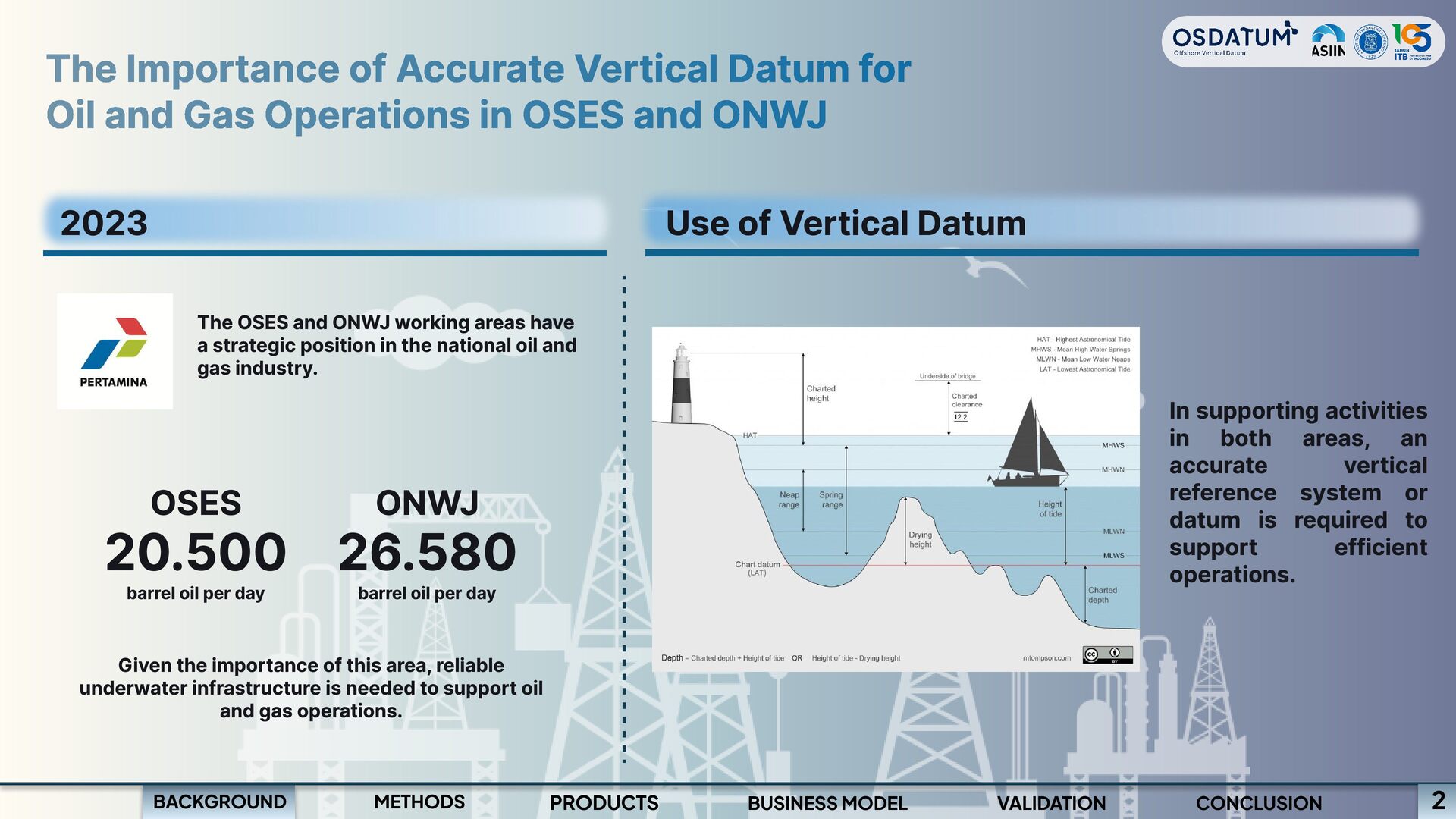
Operations in OSES and ONWJ 2023 Use of Vertical Datum The OSES and ONWJ working areas have a strategic position in the national oil and gas industry. OSES 20.500 ONWJ 26.580 barrel oil per day barrel oil per day Given the importance of this area, reliable underwater infrastructure is needed to support oil and gas operations. BACKGROUND METHODS PRODUCTS BUSINESS MODEL VALIDATION In supporting activities in both areas, an accurate vertical reference system or datum is required to support efficient operations. 2 CONCLUSION
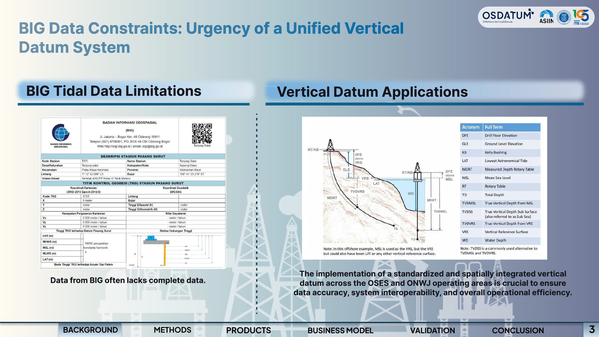
BIG Tidal Data Limitations Vertical Datum Applications The implementation of a standardized and spatially integrated vertical datum across the OSES and ONWJ operating areas is crucial to ensure data accuracy, system interoperability, and overall operational efficiency. Data from BIG often lacks complete data. BACKGROUND METHODS PRODUCTS BUSINESS MODEL VALIDATION CONCLUSION 3
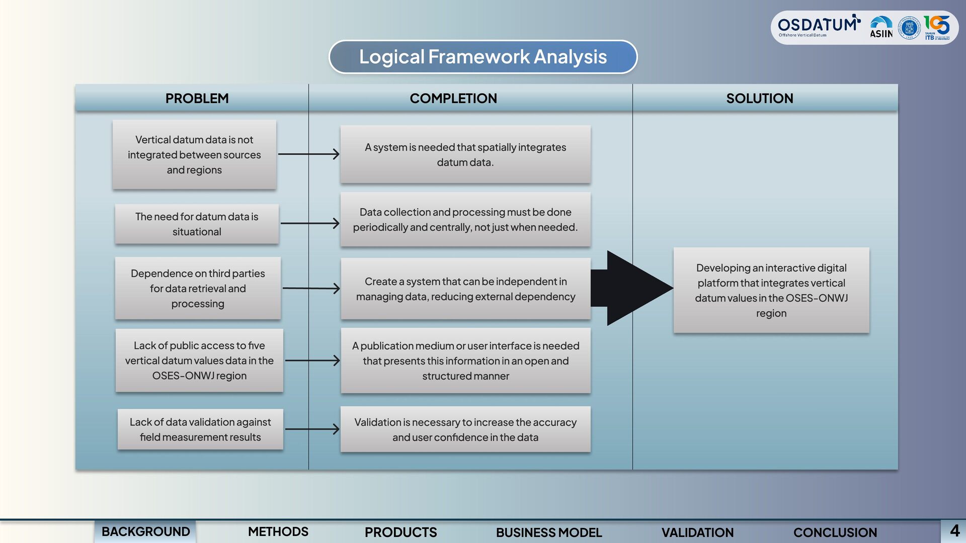
sources and regions The need for datum data is situational Dependence on third parties for data retrieval and processing Lack of public access to five vertical datum values data in the OSES-ONWJ region Lack of data validation against field measurement results PROBLEM A system is needed that spatially integrates datum data. Data collection and processing must be done periodically and centrally, not just when needed. Validation is necessary to increase the accuracy and user confidence in the data Create a system that can be independent in managing data, reducing external dependency A publication medium or user interface is needed that presents this information in an open and structured manner COMPLETION Developing an interactive digital platform that integrates vertical datum values in the OSES-ONWJ region SOLUTION BACKGROUND METHODS PRODUCTS BUSINESS MODEL VALIDATION CONCLUSION 4
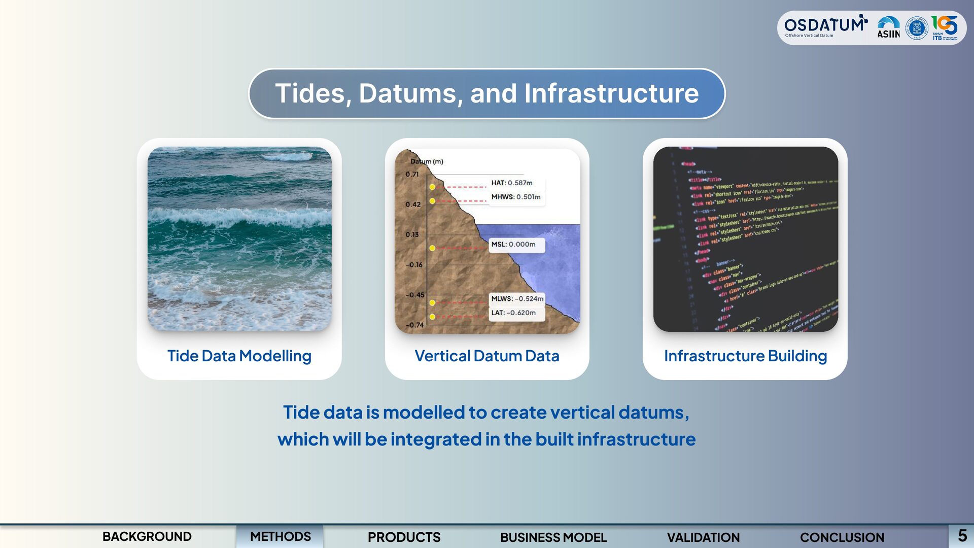
Infrastructure Building Tide data is modelled to create vertical datums, which will be integrated in the built infrastructure METHODS BACKGROUND PRODUCTS BUSINESS MODEL VALIDATION CONCLUSION 5
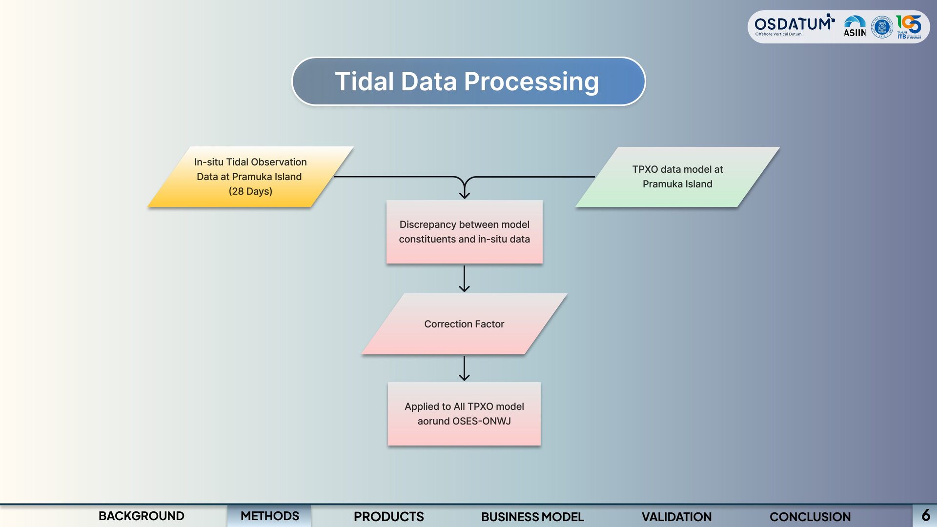
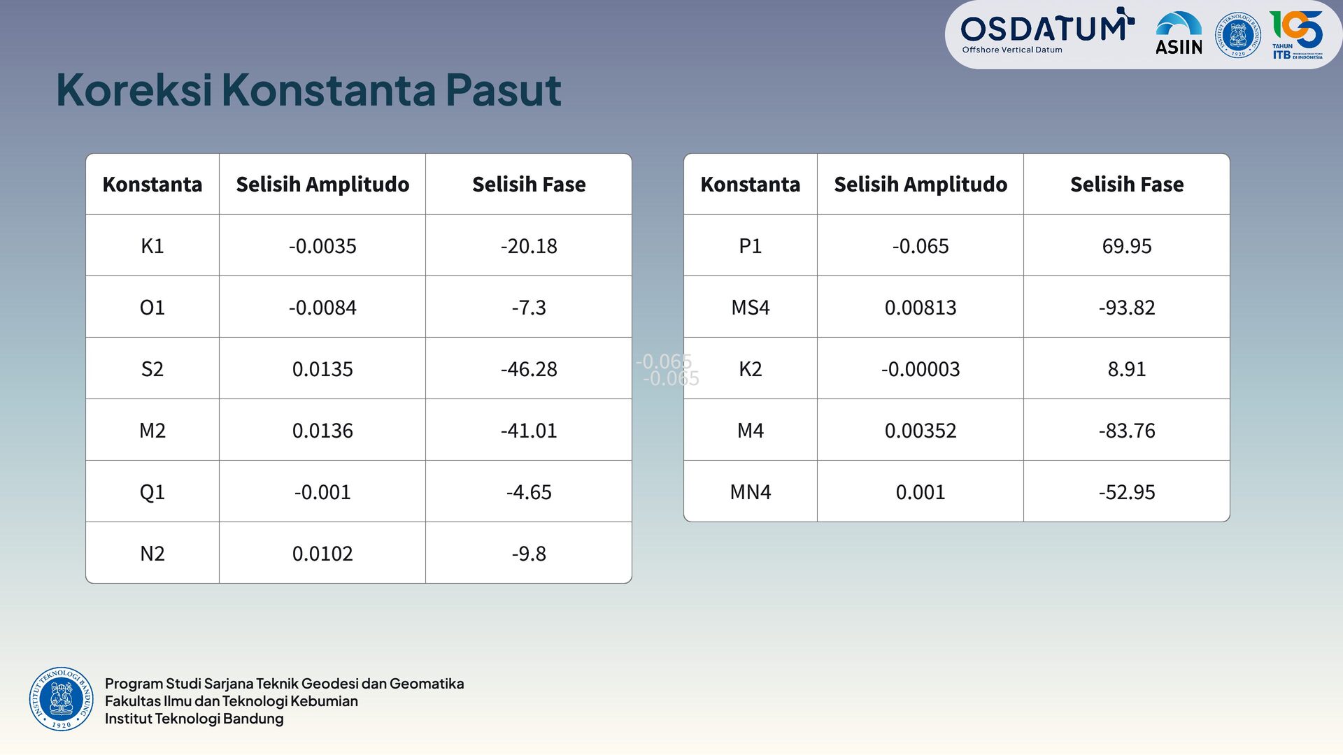
(28 Days) TPXO data model at Pramuka Island Discrepancy between model constituents and in-situ data Correction Factor Applied to All TPXO model aorund OSES-ONWJ METHODS BACKGROUND PRODUCTS BUSINESS MODEL VALIDATION CONCLUSION 6
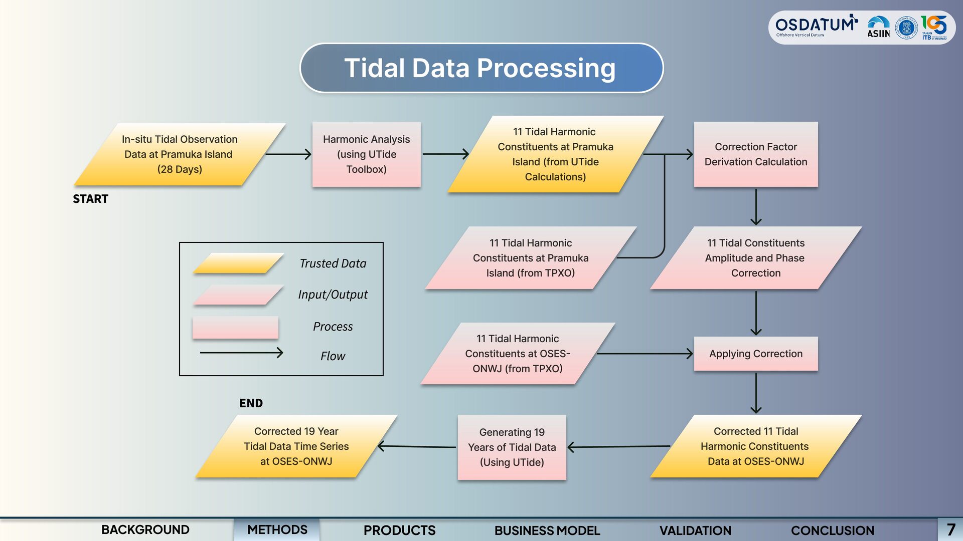
(from UTide Calculations) Harmonic Analysis (using UTide Toolbox) Correction Factor Derivation Calculation In-situ Tidal Observation Data at Pramuka Island (28 Days) START 11 Tidal Harmonic Constituents at Pramuka Island (from TPXO) 11 Tidal Constituents Amplitude and Phase Correction Trusted Data Input/Output Process Flow 11 Tidal Harmonic Constituents at OSES- ONWJ (from TPXO) Applying Correction END Corrected 19 Year Tidal Data Time Series at OSES-ONWJ Generating 19 Years of Tidal Data (Using UTide) Corrected 11 Tidal Harmonic Constituents Data at OSES-ONWJ METHODS BACKGROUND PRODUCTS BUSINESS MODEL VALIDATION CONCLUSION 7
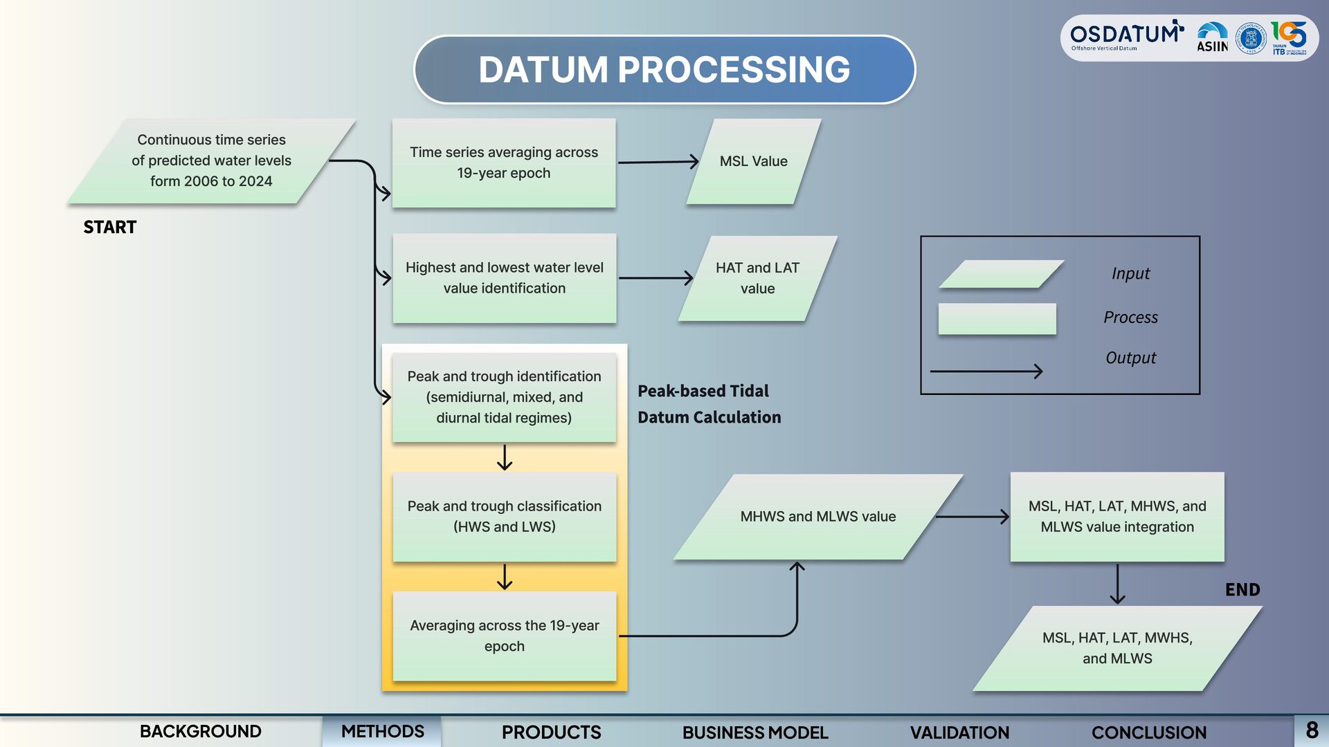
Highest and lowest water level value identification HAT and LAT value Peak-based Tidal Datum Calculation Continuous time series of predicted water levels form 2006 to 2024 START Input Process Output Peak and trough identification (semidiurnal, mixed, and diurnal tidal regimes) Peak and trough classification (HWS and LWS) Averaging across the 19-year epoch MSL, HAT, LAT, MHWS, and MLWS value integration END MSL, HAT, LAT, MWHS, and MLWS VALIDATION CONCLUSION MHWS and MLWS value METHODS BACKGROUND PRODUCTS BUSINESS MODEL 8
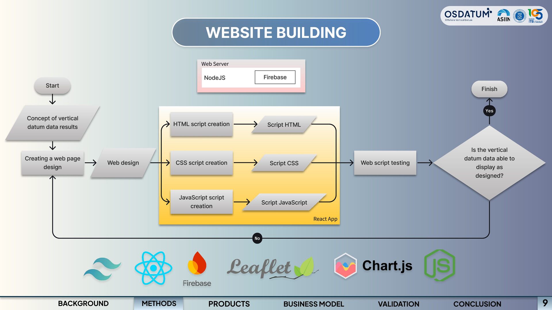
datum data results Creating a web page design Finish Yes No Web design HTML script creation CSS script creation JavaScript script creation Script JavaScript Script HTML Script CSS React App Is the vertical datum data able to display as designed? Web script testing 9 METHODS BACKGROUND PRODUCTS BUSINESS MODEL VALIDATION CONCLUSION
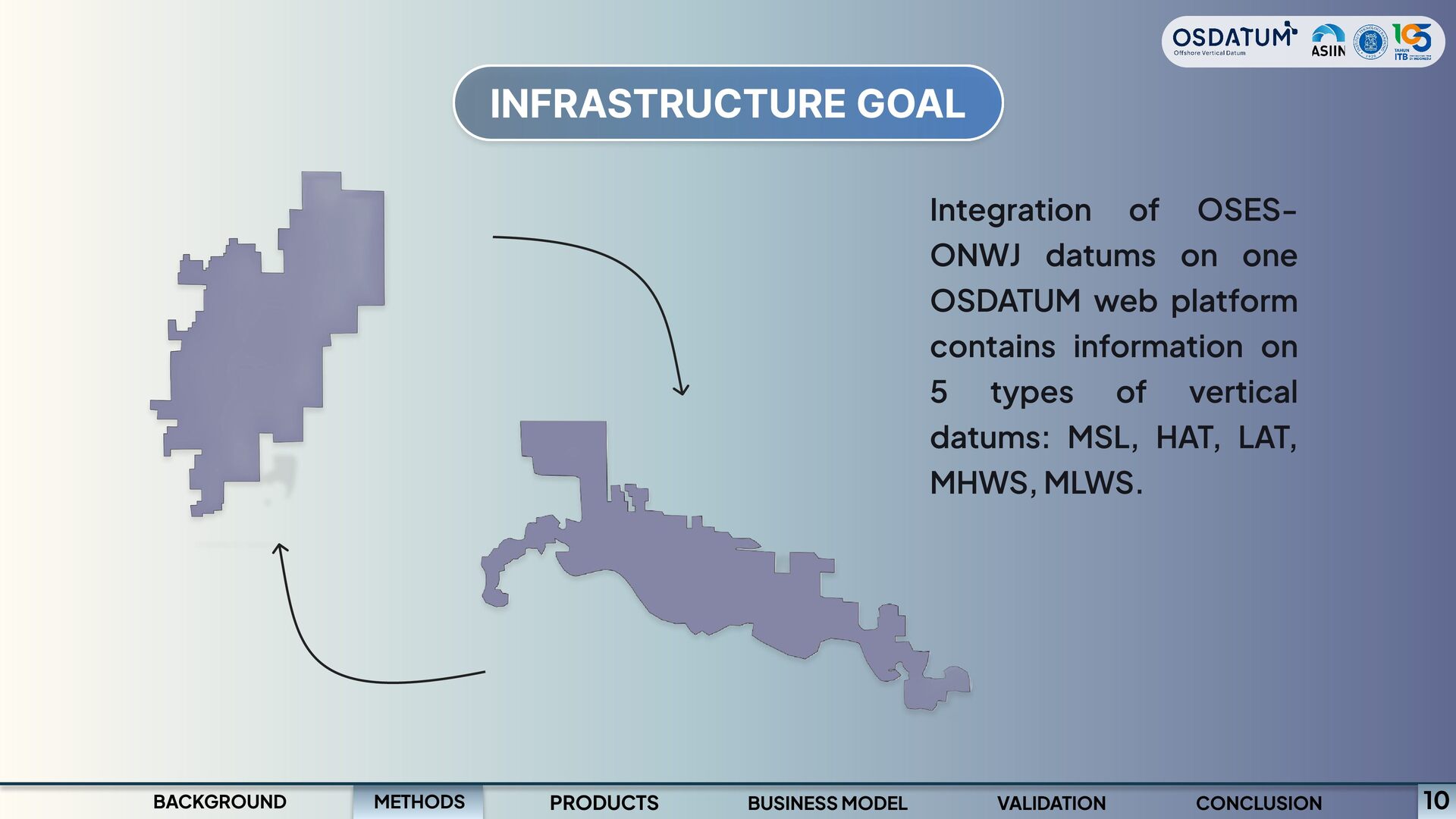
one OSDATUM web platform contains information on 5 types of vertical datums: MSL, HAT, LAT, MHWS, MLWS. PRODUCTS BUSINESS MODEL VALIDATION CONCLUSION 10
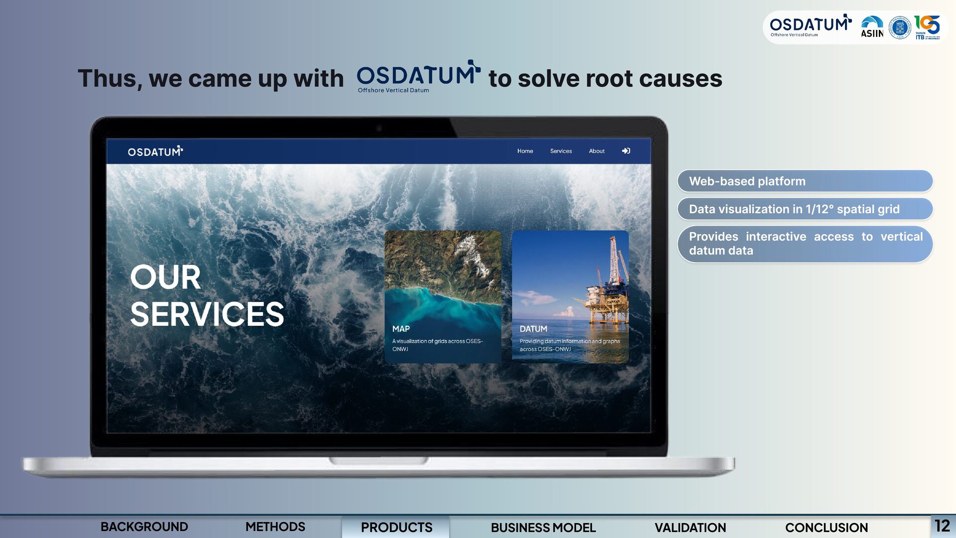
platform Data visualization in 1/12° spatial grid Provides interactive access to vertical datum data PRODUCTS BACKGROUND METHODS BUSINESS MODEL VALIDATION CONCLUSION 12
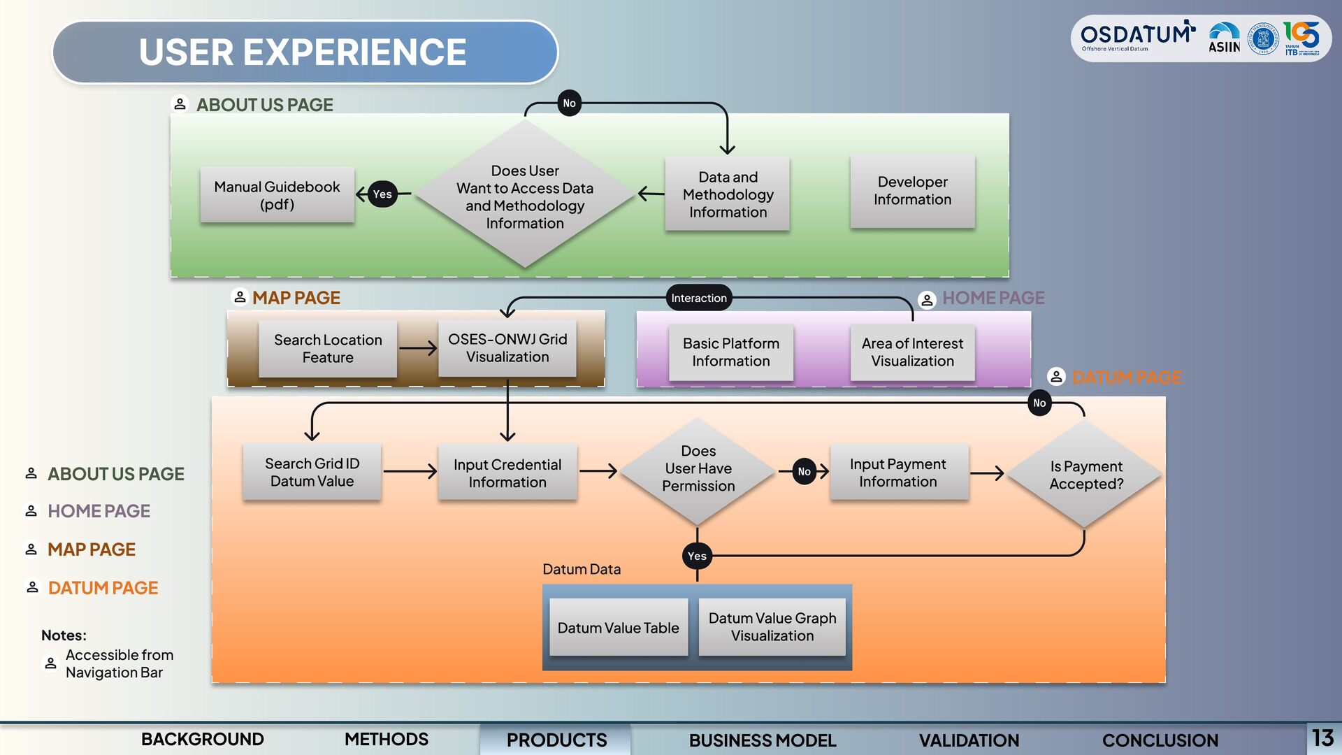
Access Data and Methodology Information Data and Methodology Information HOME PAGE Interaction OSES-ONWJ Grid Visualization Basic Platform Information Area of Interest Visualization Developer Information Manual Guidebook (pdf) Yes MAP PAGE Search Location Feature No DATUM PAGE Does User Have Permission Input Payment Information No Yes Datum Data Datum Value Table Datum Value Graph Visualization Search Grid ID Datum Value Input Credential Information Is Payment Accepted? ABOUT US PAGE HOME PAGE MAP PAGE DATUM PAGE Notes: Accessible from Navigation Bar PRODUCTS BACKGROUND METHODS BUSINESS MODEL VALIDATION CONCLUSION 13
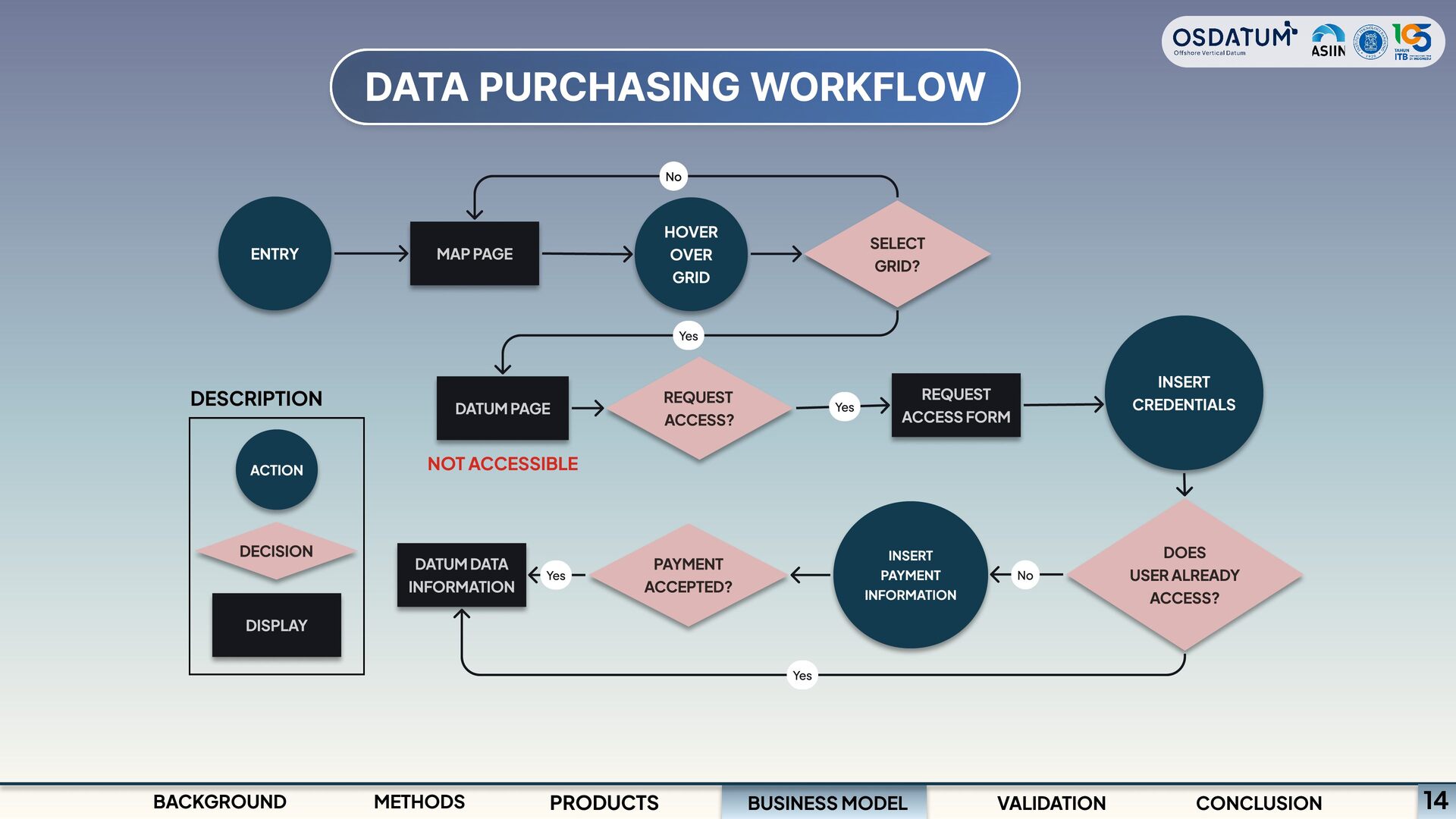
Yes REQUEST ACCESS? HOVER OVER GRID SELECT GRID? REQUEST ACCESS FORM MAP PAGE INSERT CREDENTIALS Yes DATUM PAGE NOT ACCESSIBLE Yes PAYMENT ACCEPTED? INSERT PAYMENT INFORMATION DOES USER ALREADY ACCESS? DATUM DATA INFORMATION Yes No BUSINESS MODEL METHODS PRODUCTS VALIDATION CONCLUSION 14
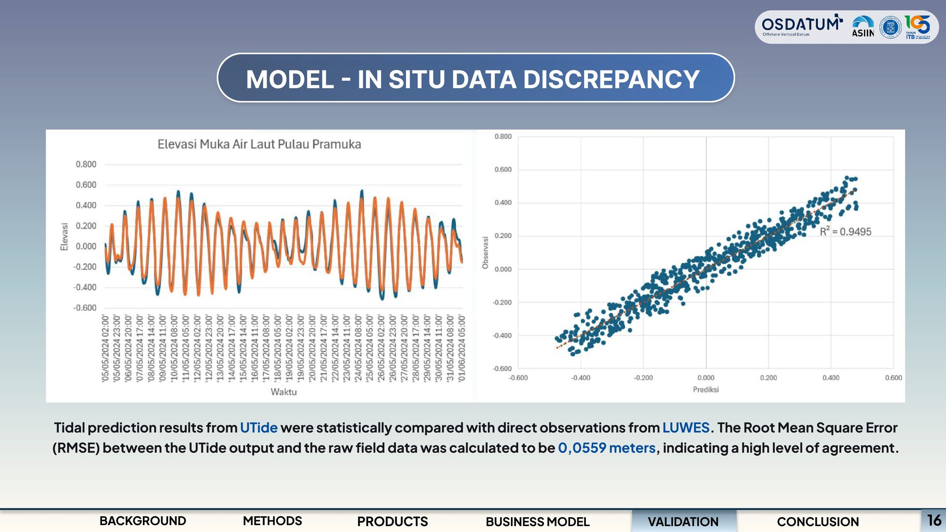
UTide were statistically compared with direct observations from LUWES. The Root Mean Square Error (RMSE) between the UTide output and the raw field data was calculated to be 0,0559 meters, indicating a high level of agreement. VALIDATION BACKGROUND METHODS PRODUCTS BUSINESS MODEL CONCLUSION 16
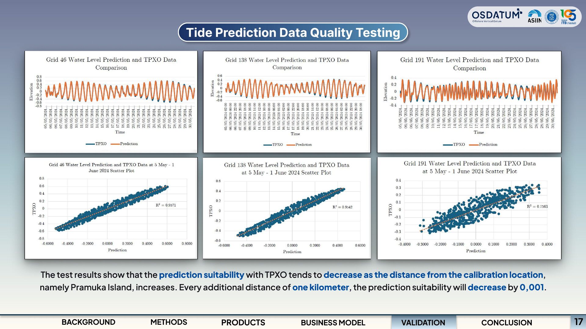
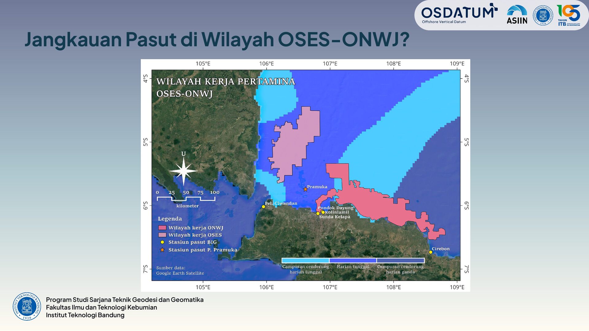
the prediction suitability with TPXO tends to decrease as the distance from the calibration location, namely Pramuka Island, increases. Every additional distance of one kilometer, the prediction suitability will decrease by 0,001. VALIDATION BACKGROUND METHODS PRODUCTS BUSINESS MODEL CONCLUSION 17
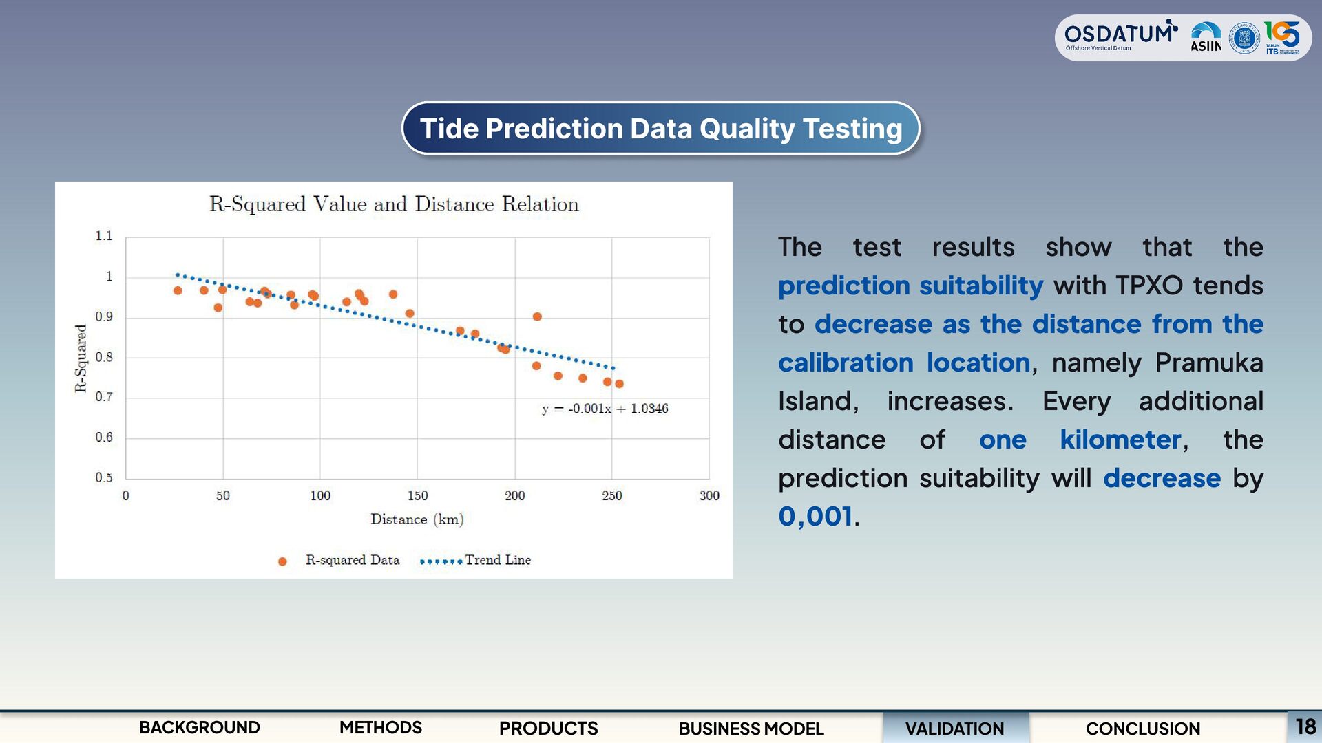
that the prediction suitability with TPXO tends to decrease as the distance from the calibration location, namely Pramuka Island, increases. Every additional distance of one kilometer, the prediction suitability will decrease by 0,001. VALIDATION METHODS PRODUCTS BUSINESS MODEL CONCLUSION 18
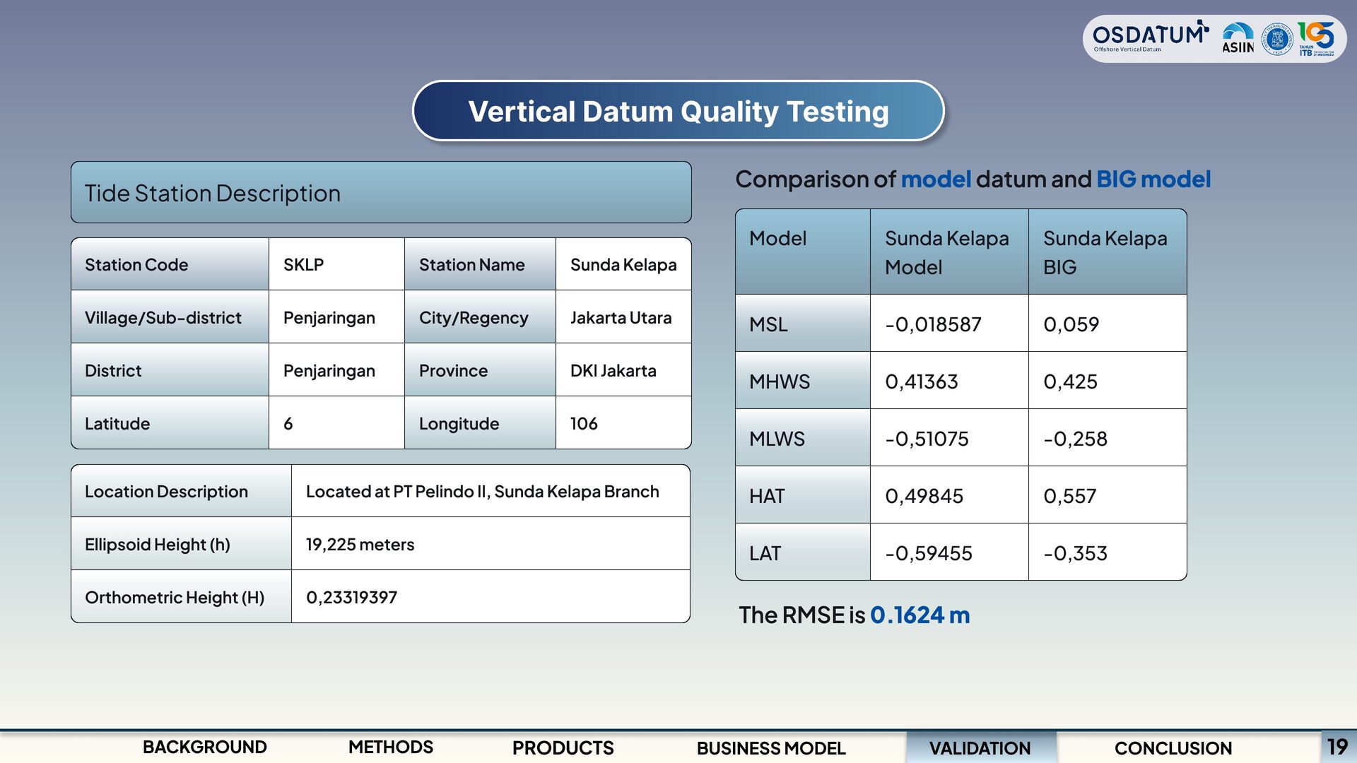
datum and BIG model Model MSL MHWS MLWS HAT LAT Sunda Kelapa Model -0,018587 0,41363 -0,51075 0,49845 -0,59455 Sunda Kelapa BIG 0,059 0,425 -0,258 0,557 -0,353 Station Code Village/Sub-district District Latitude SKLP Penjaringan Penjaringan 6 Station Name City/Regency Province Longitude Sunda Kelapa Jakarta Utara DKI Jakarta 106 Location Description Ellipsoid Height (h) Orthometric Height (H) Located at PT Pelindo II, Sunda Kelapa Branch 19,225 meters 0,23319397 The RMSE is 0.1624 m VALIDATION BACKGROUND METHODS PRODUCTS BUSINESS MODEL CONCLUSION 19
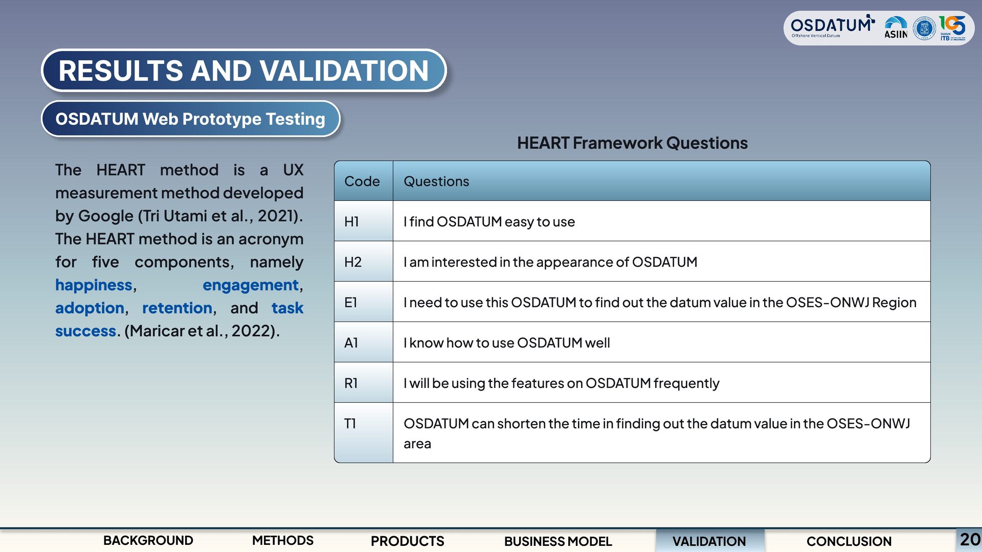
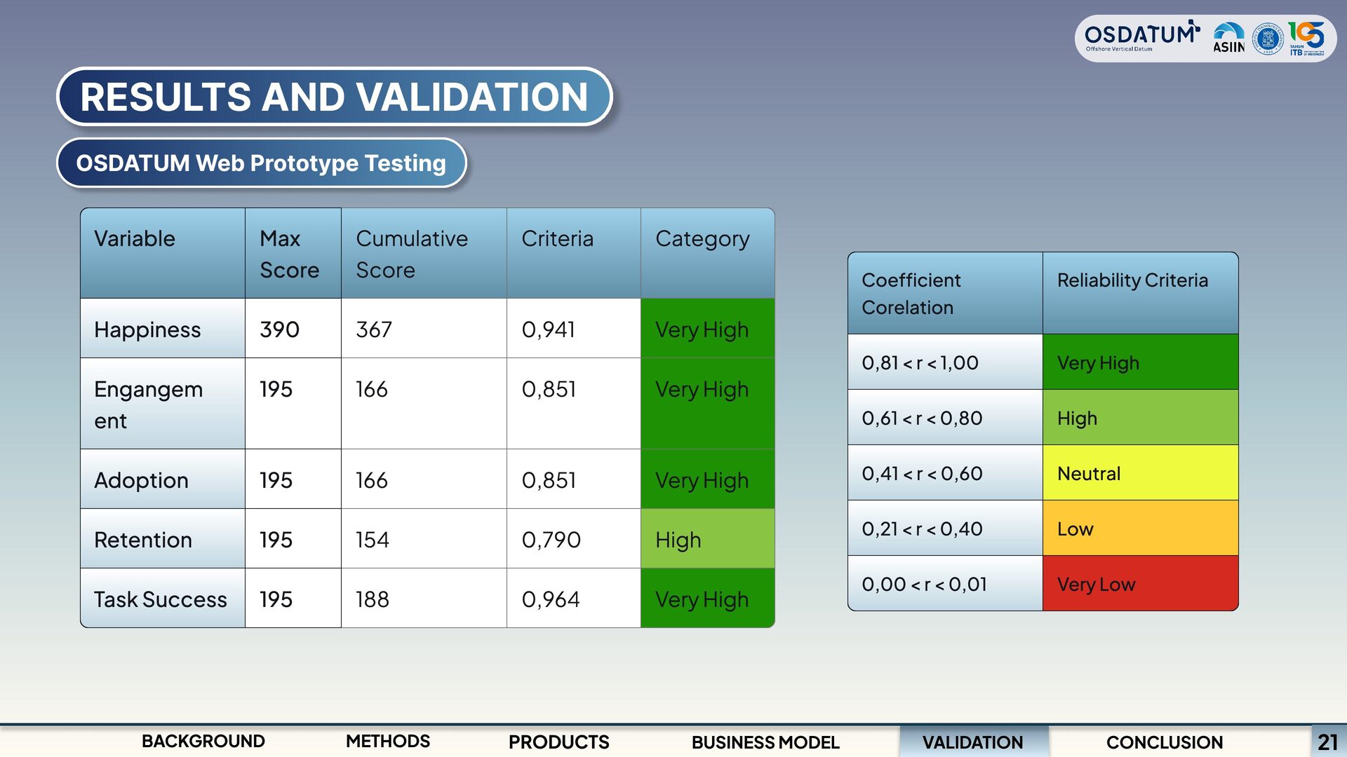
Code H1 H2 E1 A1 R1 T1 Questions I find OSDATUM easy to use I am interested in the appearance of OSDATUM I need to use this OSDATUM to find out the datum value in the OSES-ONWJ Region I know how to use OSDATUM well I will be using the features on OSDATUM frequently OSDATUM can shorten the time in finding out the datum value in the OSES-ONWJ area The HEART method is a UX measurement method developed by Google (Tri Utami et al., 2021). The HEART method is an acronym for five components, namely happiness, engagement, adoption, retention, and task success. (Maricar et al., 2022). VALIDATION BACKGROUND METHODS PRODUCTS BUSINESS MODEL CONCLUSION 20
ent Adoption Retention Task Success Max Score 390 195 195 195 195 Cumulative Score 367 166 166 154 188 Criteria 0,941 0,851 0,851 0,790 0,964 Category Very High Very High Very High High Very High BACKGROUND METHODS PRODUCTS BUSINESS MODEL Coefficient Corelation 0,81 < r < 1,00 0,61 < r < 0,80 0,41 < r < 0,60 0,21 < r < 0,40 0,00 < r < 0,01 Reliability Criteria Very High High Neutral Low Very Low VALIDATION CONCLUSION 21
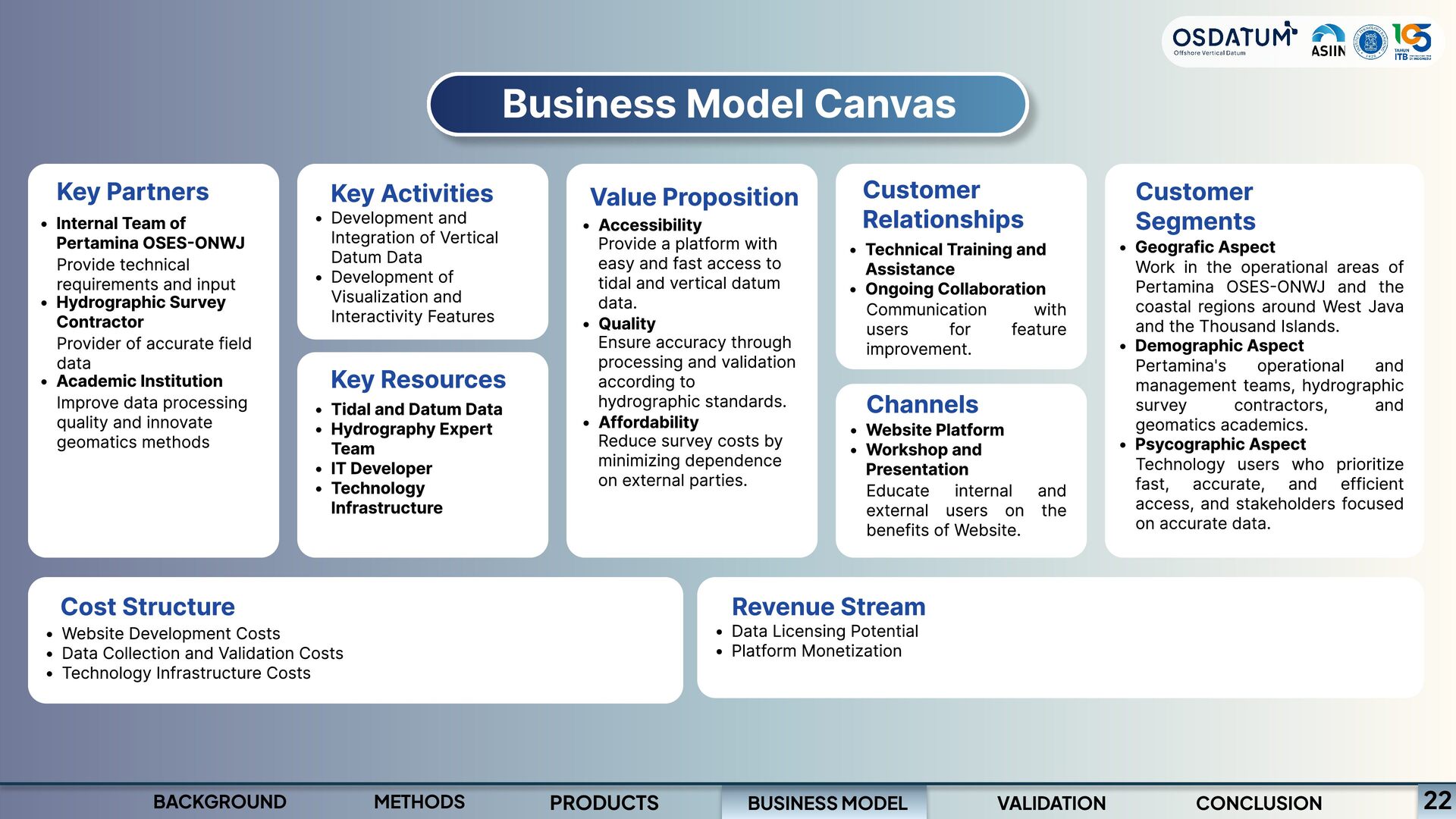
Collaboration Communication with users for feature improvement. Channels Website Platform Workshop and Presentation Educate internal and external users on the benefits of Website. Key Partners Customer Segments Development and Integration of Vertical Datum Data Development of Visualization and Interactivity Features Key Activities Value Proposition Internal Team of Pertamina OSES-ONWJ Hydrographic Survey Contractor Academic Institution Provide technical requirements and input Provider of accurate field data Improve data processing quality and innovate geomatics methods Accessibilit y Quality Affordability Provide a platform with easy and fast access to tidal and vertical datum data. Ensure accuracy through processing and validation according to hydrographic standards. Reduce survey costs by minimizing dependence on external parties. G eografic Aspect Demographic Aspect Psycographic Aspect Work in the operational areas of Pertamina OSES-ONWJ and the coastal regions around West Java and the Thousand Islands. Pertamina's operational and management teams, hydrographic survey contractors, and geomatics academics. Technology users who prioritize fast, accurate, and efficient access, and stakeholders focused on accurate data. Key Resources Tidal and Datum Data Hydrography Expert Team IT Developer Technology Infrastructure Cost Structure Website Development Costs Data Collection and Validation Costs Technology Infrastructure Costs Data Licensing Potential Platform Monetization Revenue Stream BUSINESS MODEL BACKGROUND METHODS PRODUCTS VALIDATION CONCLUSION 22
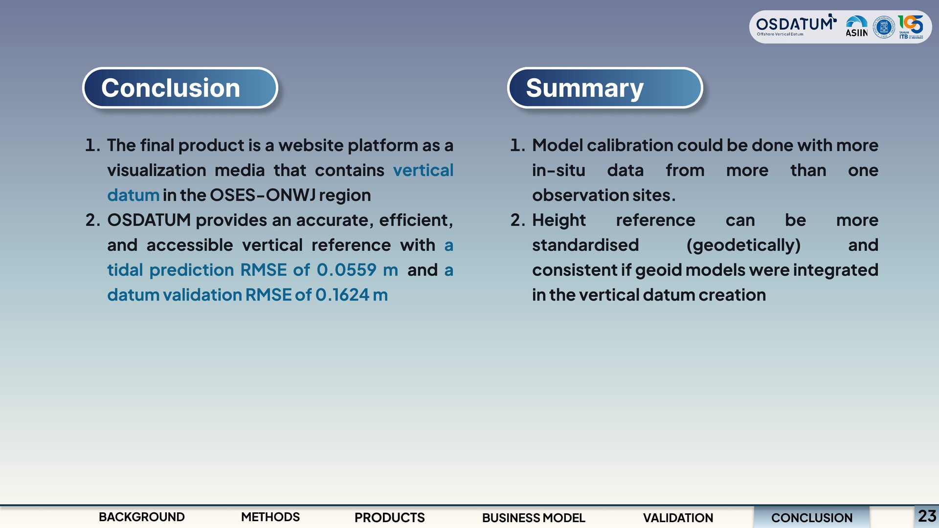
visualization media that contains vertical datum in the OSES-ONWJ region OSDATUM provides an accurate, efficient, and accessible vertical reference with a tidal prediction RMSE of 0.0559 m and a datum validation RMSE of 0.1624 m BACKGROUND METHODS PRODUCTS Summary Model calibration could be done with more in-situ data from more than one observation sites. Height reference can be more standardised (geodetically) and consistent if geoid models were integrated in the vertical datum creation CONCLUSION BUSINESS MODEL VALIDATION 23
Selisih Amplitudo -0.0035 -0.0084 0.0135 0.0136 -0.001 0.0102 Selisih Fase -20.18 -7.3 -46.28 -41.01 -4.65 -9.8 -0.065 -0.065 -0.065 Konstanta P1 MS4 K2 M4 MN4 Selisih Amplitudo -0.065 0.00813 -0.00003 0.00352 0.001 Selisih Fase 69.95 -93.82 8.91 -83.76 -52.95 Program Studi Sarjana Teknik Geodesi dan Geomatika Fakultas Ilmu dan Teknologi Kebumian Institut Teknologi Bandung
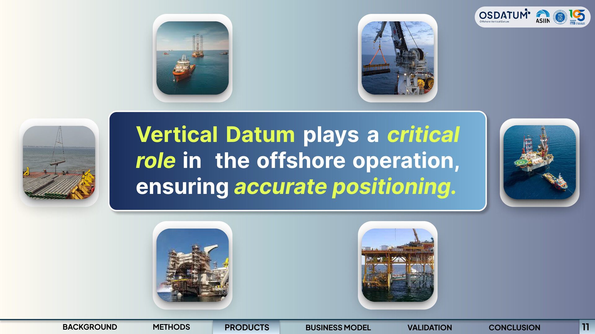
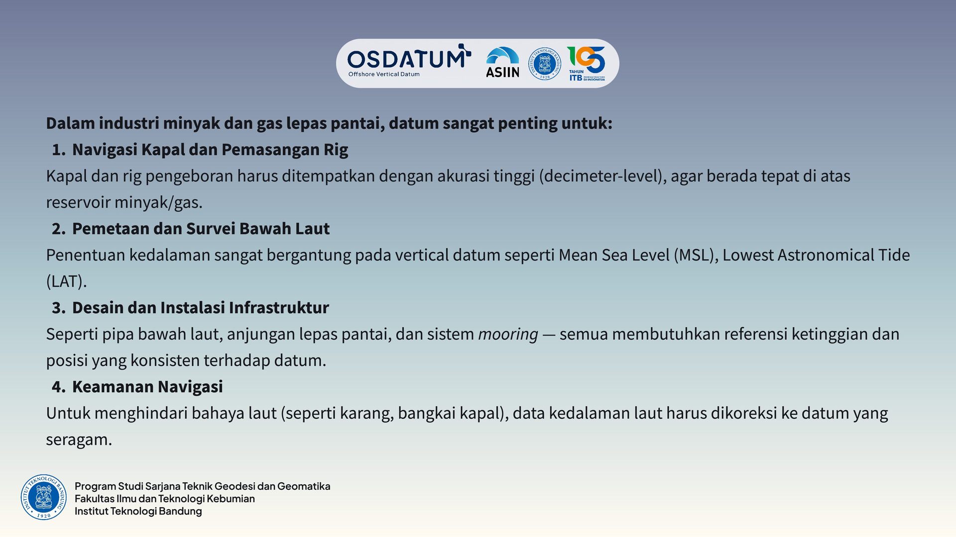
untuk: Navigasi Kapal dan Pemasangan Rig Kapal dan rig pengeboran harus ditempatkan dengan akurasi tinggi (decimeter-level), agar berada tepat di atas reservoir minyak/gas. Pemetaan dan Survei Bawah Laut Penentuan kedalaman sangat bergantung pada vertical datum seperti Mean Sea Level (MSL), Lowest Astronomical Tide (LAT). Desain dan Instalasi Infrastruktur Seperti pipa bawah laut, anjungan lepas pantai, dan sistem mooring — semua membutuhkan referensi ketinggian dan posisi yang konsisten terhadap datum. Keamanan Navigasi Untuk menghindari bahaya laut (seperti karang, bangkai kapal), data kedalaman laut harus dikoreksi ke datum yang seragam. Program Studi Sarjana Teknik Geodesi dan Geomatika Fakultas Ilmu dan Teknologi Kebumian Institut Teknologi Bandung
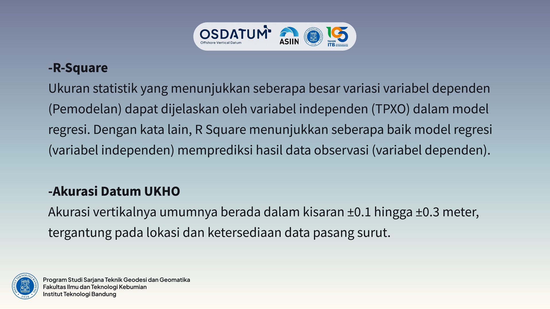
(Pemodelan) dapat dijelaskan oleh variabel independen (TPXO) dalam model regresi. Dengan kata lain, R Square menunjukkan seberapa baik model regresi (variabel independen) memprediksi hasil data observasi (variabel dependen). -Akurasi Datum UKHO Akurasi vertikalnya umumnya berada dalam kisaran ±0.1 hingga ±0.3 meter, tergantung pada lokasi dan ketersediaan data pasang surut. Program Studi Sarjana Teknik Geodesi dan Geomatika Fakultas Ilmu dan Teknologi Kebumian Institut Teknologi Bandung


 mfonobong
 dougneiner
 madoxten
 tessaabrams
 inesmontani
 leimatthew05
 addyosmani
 tonyrice
 coloredviolet
 soudai
 chrisshort
 marcelosomers