Upgrade to Pro — share decks privately, control downloads, hide ads and more …

Processing High Resolution Satellite Data with Satpy

David Hoese
October 02, 2019

Processing High Resolution Satellite Data with Satpy

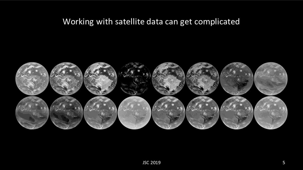
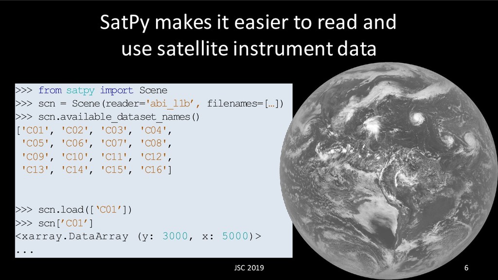
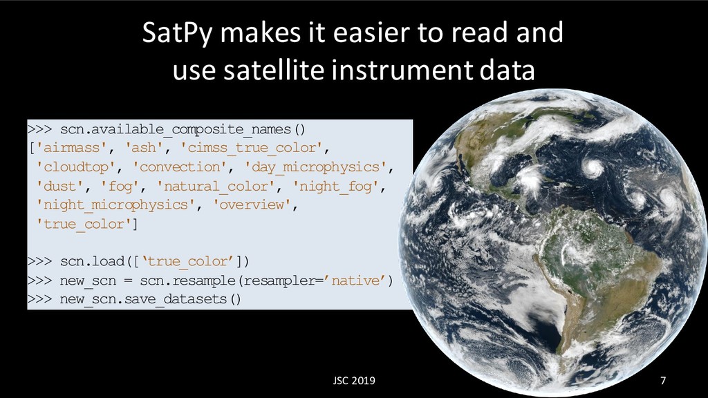
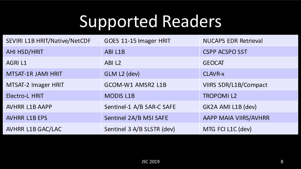
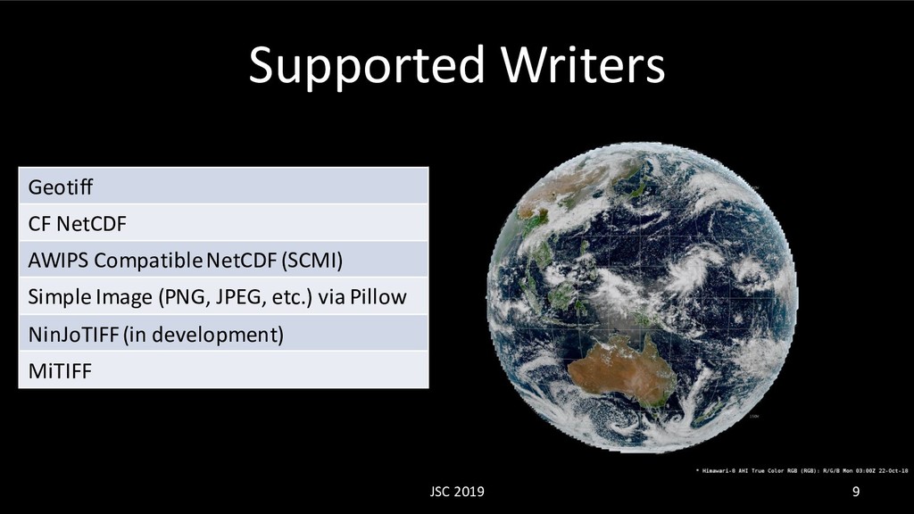
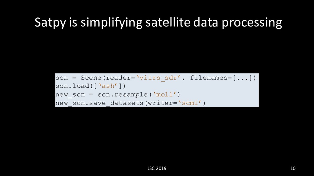
Presented at the 2019 Joint Satellite Conference in Boston, MA. This presentation is intended for scientists who are familiar with meteorological satellite instrument data. No programming experience should be needed to understand the slides although some slides do have code in them.

David Hoese

October 02, 2019
Tweet

Other Decks in Science

Transcript

  1. David Hoese Space Science and Engineering Center University of Wisconsin

    - Madison JSC 2019 1 Processing High Resolution Satellite Data With Satpy
  2. David Hoese (Haze) • Software Developer SSEC/CIMSS University of Wisconsin

    – Madison • Pytroll Developer • Open Source Contributor JSC 2019 2
  3. SatPy makes it easier to read and use satellite instrument

    data JSC 2019 6 >>> from satpy import Scene >>> scn = Scene(reader='abi_l1b’, filenames=[…]) >>> scn.available_dataset_names() ['C01', 'C02', 'C03', 'C04', 'C05', 'C06', 'C07', 'C08', 'C09', 'C10', 'C11', 'C12', 'C13', 'C14', 'C15', 'C16'] >>> scn.load([‘C01’]) >>> scn[’C01’] <xarray.DataArray (y: 3000, x: 5000)> ...
  4. SatPy makes it easier to read and use satellite instrument

    data >>> scn.available_composite_names() ['airmass', 'ash', 'cimss_true_color', 'cloudtop', 'convection', 'day_microphysics', 'dust', 'fog', 'natural_color', 'night_fog', 'night_microphysics', 'overview', 'true_color'] >>> scn.load([‘true_color’]) >>> new_scn = scn.resample(resampler=’native’) >>> new_scn.save_datasets() 7 JSC 2019
  5. Supported Readers JSC 2019 8 SEVIRI L1B HRIT/Native/NetCDF GOES 11-15

    Imager HRIT NUCAPS EDR Retrieval AHI HSD/HRIT ABI L1B CSPP ACSPO SST AGRI L1 ABI L2 GEOCAT MTSAT-1R JAMI HRIT GLM L2 (dev) CLAVR-x MTSAT-2 Imager HRIT GCOM-W1 AMSR2 L1B VIIRS SDR/L1B/Compact Electro-L HRIT MODIS L1B TROPOMI L2 AVHRR L1B AAPP Sentinel-1 A/B SAR-C SAFE GK2A AMI L1B (dev) AVHRR L1B EPS Sentinel 2A/B MSI SAFE AAPP MAIA VIIRS/AVHRR AVHRR L1B GAC/LAC Sentinel 3 A/B SLSTR (dev) MTG FCI L1C (dev)
  6. Supported Writers JSC 2019 9 Geotiff CF NetCDF AWIPS Compatible

    NetCDF (SCMI) Simple Image (PNG, JPEG, etc.) via Pillow NinJoTIFF (in development) MiTIFF
  7. Satpy is simplifying satellite data processing JSC 2019 10 scn

    = Scene(reader=‘viirs_sdr’, filenames=[...]) scn.load([‘ash’]) new_scn = scn.resample(‘moll’) new_scn.save_datasets(writer=‘scmi’)
  8. Not talked about... JSC 2019 11 • Video creation •

    Custom composites • Custom enhancements • Add coastlines/decorations • Compatibility with other open source tools • Cartopy • Geoviews • Xarray plotting
  9. Ron Goodson Environment and Climate Change Canada JSC 2019 13

    Total Precipitable Water composites with age borders
  10. Simon Proud National Centre for Earth Observation, University of Oxford,

    UK JSC 2019 14 Calibration and resampling feeding cloud and aerosol properties retrieval algorithm
  11. Jorge Bravo Civil Protection of the Veracruz State (Mexico) JSC

    2019 16 Operational monitoring of weather conditions (no receiving antenna with NOAA Big Data Project)
  12. David Hoese JSC 2019 17 $ geo2grid.sh abi_l1b geotiff -f

    /path/to/files -p C01 true_color CSPP Geo Geo2Grid and CSPP Polar2Grid
  13. Satpy is growing thanks to all of the contributors JSC

    2019 19 • Satpy 0.17 is out • 4-6 week release schedule • Pytroll Contributor Weeks every Spring and Fall!
  14. Contact Me • Twitter: djhoese • Github: djhoese • Email:

    [email protected] • Code: https://github.com/pytroll/satpy • Docs: https://satpy.readthedocs.io/ • Pytroll: http://pytroll.github.io/ • Slack: https://pytroll.slack.com/ • Mailing List: https://groups.google.com/forum/#!forum/pytroll JSC 2019 20