Upgrade to Pro — share decks privately, control downloads, hide ads and more …

Geospatial Data in R

Geospatial Data in R

This lecture is designed to give a short introduction to some of the key concepts of using R to conduct geospatial analysis.

Michael Harper

August 25, 2017
Tweet

More Decks by Michael Harper

Other Decks in Technology

Transcript

  1. Uses of Spatial Data in Science • spatial analysis: using

    location or spatial relationships as an explanatory or predictive variable • examining the effects of scale • backdrops to show context Figure 1: Cholera Map of 1854 London Outbreak 2 / 66
  2. GIS vs. R • Many tools options also available •

    Other tools avaialble (QGIS, Python) Which tool is best to use? Well, it depends on the task! 3 / 66
  3. GIS vs. R GIS • Visual interaction • Data management

    • Geometric operations • Standard workflows • Single map production • Click, click, click, click • Speed of execution R • Data and model focused • Analysis • Attributes as important • Creativity and innovation • Many (simpler) maps • Repeatability (script) • Speed of development 4 / 66
  4. Challenges with Spatial Data in R Understanding and manipulating spatial

    data in R can be a real challenge! • Many types and formats of spatial data • R is not the easiest program to learn • There are a many packages from a very diverse user community 7 / 66
  5. Presentation Goals 1. Help you get to the point where

    you can do basic analysis or visualization 2. Point out some of the commonly-used packages for spatial data manipulation and analysis 3. Be a resource you can come back to 4. Provide Guidance on useful resources to use after the course Beware of the learning curve! Takes patience to master. 8 / 66
  6. Outline 1. Creating Spatial Objects 2. Data Table Operations 3.

    Coordinate Systems and Reprojection 4. Geoprocessing 5. Presenting Results Subjects Omitted More advanced visualization, Spatial statistics, Geodatabases, Network analysis, Many other... 9 / 66
  7. Before We Start… • Many packages are used within the

    analysis. library(rgdal) # loads geospatial libraries library(rgeos) # dealing with geospatial files library(sp) # spatial projections library(raster) # loading rasters and geoprocessing library(ggplot2) # Creating maps library(spatstat) # Used for spatial statistics • Don’t worry for now. These will be explained in more detail later. 10 / 66
  8. Representing Physical Features Figure 4: Representation of Figure Layers Figure

    5: Raster Features Figure 6: Vector Features 12 / 66
  9. Creating SpatialPoints Objects • The package sp is primarily used

    for creating spatial data types • The code getClass('Spatial') can be run to see all types Three options to create spatial data in R: 1. Create from scratch 2. Promote a data frame with X and Y columns 3. Import a GIS file • Methods 2 and 3 are most commonly used! • Tutorial will focus on creation of Points 13 / 66
  10. Method 1: Create a SpatialPoints Object from Scratch • Let’s

    create an example dataset! library(sp) # create a set of random coordinates xy <- matrix(data = runif(n = 100), ncol = 2) head(xy, n = 3) # show first three rows ## [,1] [,2] ## [1,] 0.3624658 0.1637974 ## [2,] 0.6252937 0.6651115 ## [3,] 0.8885394 0.8519063 • SpatialPoints function can be used to create a dataset from XY coordinates xySp <- SpatialPoints(xy) 14 / 66
  11. Method 1: Create a SpatialPoints Object from Scratch SpatialPoints can

    be plotted as typical XY data using the plot() function plot(xySp, axes = TRUE, main = "Example Spatial Data Points") 0.0 0.2 0.4 0.6 0.8 1.0 0.0 0.2 0.4 0.6 0.8 Example Spatial Data Points 15 / 66
  12. Method 2: Promote a DataFrame to a SpatialPointsDataFrame • It

    is unlikely you will use Method 1 often • You will more likely have an existing dataset with XY coordinates. • For the tutorial, We will used the canada.cities dataset from the maps package. library(maps) head(canada.cities, n = 3) ## name country.etc pop lat long capital ## 1 Abbotsford BC BC 157795 49.06 -122.30 0 ## 2 Acton ON ON 8308 43.63 -80.03 0 ## 3 Acton Vale QC QC 5153 45.63 -72.57 0 • Data already has X (long) and Y (lat) references. 16 / 66
  13. Method 2: Promote a DataFrame to a SpatialPointsDataFrame • We

    must let R know which columns are the X and Y coordinates # Create a new variable to edit the data cities <- canada.cities # State which columns contain the x and y # coordinates coordinates(cities) <- ~long + lat • By assigning coordinates we create a SpatialPointsDataFrame: class(cities) ## [1] "SpatialPointsDataFrame" ## attr(,"package") ## [1] "sp" 17 / 66
  14. Method 2: Promote a DataFrame to a SpatialPointsDataFrame We can

    map the results of the SpatialDataFrame as before: plot(cities, axes = TRUE, main = "Cities in Canada", xlab = "Longitude", ylab = "Latitude") −140 −120 −100 −80 −60 45 55 65 Cities in Canada Longitude Latitude • This map is not very useful yet! We will add to this map later! 18 / 66
  15. Method 3: Import a GIS File • Package rgdal has

    a large set of import and export filters for both vector and raster GIS data (Shapefiles, KML, GPX etc.). • For the complete list of vector import filters, use the function ogrDrivers(). • The tutorial will focus on Shapefiles, a commonly used format in GIS software. • We will use the “scot_BNG” file. • readOGR() is the function you use to import a vector file. # Find the file path of the vectors vectorDir <- system.file("vectors", package = "rgdal") scotland <- readOGR(dsn = vectorDir, layer = "scot_BNG", verbose = FALSE) • Note: you don’t need to include the file extension when loading the object 19 / 66
  16. Method 3: Import a GIS File • Shapefiles are typically

    easy to plot straight away plot(scotland, axes = T, asp = 1, col = palette()) −2e+05 0e+00 2e+05 4e+05 6e+05 8e+05 600000 800000 1000000 1200000 • We will come back to plotting again later! 20 / 66
  17. Working with the Data Frame • You can work with

    the data frame as you would with any data frame • To use the attribute table of a SpatialPointsDataFrame, use the data slot (with ‘@’ character): names(cities@data) ## [1] "name" "country.etc" "pop" "capital" • What happened to the coordinates? • We can read them with the coordinates() function coordinates(cities)[1, ] ## long lat ## -122.30 49.06 22 / 66
  18. Calculating Summaries • SpatialDataframes can mostly be treated like a

    normal Dataframe mean(cities$pop) # Calculate Mean population ## [1] 27463.94 ggplot2::qplot(x = "", y = cities$pop, geom = "boxplot", main = "A questionable boxplot", ylab = "Population") + coord_flip() 0e+00 1e+06 2e+06 3e+06 4e+06 Population x A questionable boxplot 23 / 66
  19. Adding a Column to the Data Frame of a SPDF

    Object • Calculate new columns in the data frame # Calculate the size order of cities cities$sizerank <- rank(-cities$pop) head(cities@data, n = 5) ## name country.etc pop capital sizerank ## 1 Abbotsford BC BC 157795 0 20 ## 2 Acton ON ON 8308 0 220 ## 3 Acton Vale QC QC 5153 0 314 ## 4 Airdrie AB AB 25863 0 86 ## 5 Aklavik NT NT 643 0 915 24 / 66
  20. Filter on an Attribute • Standard R syntax can be

    used to filter SpatialDataFrames.1 # Filter cities by those with a population more # than 100,000 BigCities <- cities[cities$pop > 1e+05, ] # Count how many cities meet criteria nrow(BigCities) ## [1] 29 1Check out http://www.statmethods.net/management/subset.html 25 / 66
  21. Filter on an Attribute par(mfrow = c(1, 2)) # Plot

    graphs side by side plot(cities, axes = T, asp = 1, pch = 16, main = "Original") plot(cities, axes = T, asp = 1, pch = 16, main = "Highlighing Big Cities plot(BigCities, pch = 1, col = "red", cex = 3, add = TRUE) −140 −120 −100 −80 −60 30 50 70 90 Original −140 −120 −100 −80 −60 30 50 70 90 Highlighing Big Cities Figure 7: Subsetting of spatial dataframes 26 / 66
  22. Enriching Data • You may want to link data to

    your spatial data • e.g. deomgraphic data to census wards 27 / 66
  23. Enriching Data: Example • Let’s join some census data with

    shapefiles for the Southampton region # Load Shapefile Solent <- readOGR(dsn = "../data/SolentLEP", "Solent_revised", verbose = FALSE) head(Solent[1:4], n = 2) ## OA11CD LAD11CD LAD11NM AREA_HECT ## 0 E00116566 E07000090 Havant 5.84000000 ## 1 E00116564 E07000090 Havant 9.75000000 nrow(Solent) ## [1] 3826 28 / 66
  24. Enriching Data: Example • We can load some Census Data

    # Age data for all of the UK AgeData <- read.csv("../data/MedianAge.csv", stringsAsFactors = FALSE) head(AgeData,n=3) ## GeographyCode MedianAge ## 1 K04000001 39 ## 2 E92000001 39 ## 3 W92000004 41 nrow(AgeData) ## [1] 223722 • The age data has records for the whole of England 29 / 66
  25. Enriching Data: Example • We can easily merge the age

    data with the boundary data using the merge() function # Merge Datasets SolentMerged <- merge(Solent, AgeData, by.x = "OA11CD", by.y = "GeographyCode") # Lets focus on Southampton Southampton <- SolentMerged[SolentMerged$LAD11NM == "Southampton", ] 30 / 66
  26. Enriching Data: Example spplot(Southampton, "MedianAge", main = "Median Age (years)")

    Median Age (years) 20 30 40 50 60 70 80 Figure 8: Median Age with Output Areas in Southampton. Data from 2011 Census 31 / 66
  27. Coordinate Reference Systems (CRS) • Very important! R won’t give

    you a warning when loading like in ArcGIS. • You don’t always need to give one, but it is recommended to always do. • If you create spatial data, you will usually have to specify the projection. • packages sp and rgdal are used for managing CRS. Find out more A useful guide is provided here about spatial projection in R https://goo.gl/FAsv4k 33 / 66
  28. Coordinate Systems: Example • Earlier, we created the SpatialDataFrame of

    Canadian Cities called cities. • We can check the spatial projection using the function crs() crs(cities) ## CRS arguments: NA • Currently the data has no CRS! We need to assign one • Dataset has WGS84 projection, which is the mostly commonly used # Assign Projection to Cities crs(cities) <- CRS("+init=epsg:4326") Find out spatial projection codes An online registry of spatial projections is available at http://www.epsg-registry.org for Coordinate Reference Systems 34 / 66
  29. Coordinate Systems: Example • We will load data for administrative

    borders in Canada using the function getData() from the raster package 2. # Load Canada Data canada <- raster::getData("GADM", country = "CAN", level = 0, download = FALSE, path = "../data") # Check Coordinate System crs(canada) ## CRS arguments: ## +proj=longlat +datum=WGS84 +no_defs +ellps=WGS84 +towgs84=0,0,0 2This provides global vector and raster data for countries, administrative boundaries, altitude models and climatic data. 35 / 66
  30. Example: Reprojecting • The function spTransform() can be used to

    reproject a CRS GB <- raster::getData("GADM", country = "GBR", level = 1, path = "../data") GB_BNG <- spTransform(GB, CRS("+init=epsg:27700")) 15°W 10°W 5°W 0° 50°N 52°N 54°N 56°N 58°N 60°N WGS 1984 Coordinate System −4e+05 0e+00 4e+05 8e+05 0 200000 600000 1000000 British National Grid Figure 9: Comparison of coordinate systems 37 / 66
  31. Geoprocessing: rgeos package • rgeos is the main package used

    within R for geospatial analysis • interface to GEOS (Geometry Engine Open Source) Library Example Processes Union, distance, intersection, convex hull, envelope, buffer, simplify, polygon assembly, valid, area, length, intersects, touches, disjoint, crosses, within, contains, overlaps, equals, covers, etc. 39 / 66
  32. Buffer • apply a 2km buffer to the county of

    Inverness inver <- scotland[scotland$NAME == "Inverness", ] inver_buf <- gBuffer(inver, width = 2000) 220000 240000 260000 280000 790000 810000 830000 850000 Buffer 40 / 66
  33. Delaunay Triangulation • Form Delaunay triangulation for the cities in

    Canada delTri <- gDelaunayTriangulation(BigCities) plot(delTri, axes = TRUE, , main = "Delaunay Triangulation") plot(BigCities, col = "red", pch = 16, cex = 2, add = TRUE) 120°W 110°W 100°W 90°W 80°W 70°W 60°W 50°W 30°N 40°N 50°N 60°N 70°N Delaunay Triangulation 41 / 66
  34. Spatial Proximity • How far is it to the nearest

    city? • spatstat provides adds a spatial proximity functions. library(spatstat) BigCities$Distance <- nndist(X = BigCities@coords) spplot(BigCities, "Distance") # Plot Results [0.1879,2.411] (2.411,4.633] (4.633,6.856] (6.856,9.078] (9.078,11.3] 42 / 66
  35. Raster package • Most control through raster package • Read,

    write and manipulate gridded spatial data • Basic and high-level analysis functions • Processing of large files 44 / 66
  36. Raster Layer: Create from Scratch myrast <- raster(extent(c(0, 20, 0,

    20)), ncol = 10, nrow = 10) myrast[] <- 1:100 myrast ## class : RasterLayer ## dimensions : 10, 10, 100 (nrow, ncol, ncell) ## resolution : 2, 2 (x, y) ## extent : 0, 20, 0, 20 (xmin, xmax, ymin, ymax) ## coord. ref. : NA ## data source : in memory ## names : layer ## values : 1, 100 (min, max) 45 / 66
  37. Raster Layer: Raster Algebra • Rasters can be added, multiplied

    etc. par(mfrow = c(1, 2)) # Plot graphs side by side plot(myrast, main = "Raster Value", asp = 1) myrastSquared <- myrast^2 plot(myrastSquared, main = "Raster Value Squared", asp = 1) 0 5 10 15 20 0 5 10 15 20 Raster Value 20 40 60 80 100 0 5 10 15 20 0 5 10 15 20 Raster Value Squared 2000 4000 6000 8000 10000 46 / 66
  38. Raster Data: Import a GeoTiff • The raster() function from

    the raster package can be used WindSpeedRaster <- raster(x = "../data/WindSpeed45.tif") plot(WindSpeedRaster, "WindSpeed45") −2e+05 0e+00 2e+05 4e+05 6e+05 8e+05 0 200000 400000 600000 800000 1000000 1200000 0 2 4 6 8 10 12 14 Figure 10: UK Annualised Wind Speed Map at 45m above ground level 47 / 66
  39. Raster Data: Crop a Raster • crop() function can be

    used to clip a raster to a spatial extent WindSpeedSolent <- crop(WindSpeedRaster, Solent) plot(WindSpeedSolent, asp = 1) 430000 440000 450000 460000 470000 80000 90000 100000 110000 120000 5 6 7 8 9 48 / 66
  40. Overlay Points and Extract Values • Generate Some Points Within

    The Solent Region • The spsample() function from the package sp can to produce a sample within a given extent SolentPoints <- spsample(Solent, n = 25, type = "random") SolentPoints$ID <- 1:nrow(SolentPoints@coords) 430000 440000 450000 460000 470000 80000 90000 100000 110000 120000 5 6 7 8 9 1 2 3 4 5 6 7 8 9 10 11 12 13 14 15 16 17 18 19 20 21 22 23 24 25 49 / 66
  41. Overlay Points and Extract Values • You can use the

    extract() function to calculate the value at points. extract(WindSpeedSolent, SolentPoints) ## [1] 6 7 NA 6 7 6 6 7 6 6 6 7 6 8 7 6 7 9 6 7 8 6 6 ## [24] 7 6 50 / 66
  42. Create a Distance Surface • The function distance() can produce

    a proximity raster to the nearest spatial point • We must first rasterize() the Vector data (SpatialPoints) SolentPointsRast <- rasterize(SolentPoints, WindSpeedSolent, field = 1) dist2SamplePtsRast <- distance(SolentPointsRast) Original Points 430000 460000 80000 110000 Rasterized Points 430000 460000 80000 110000 Proximity Raster 0 5000 10000 15000 51 / 66
  43. ggplot: the basics • Maps so far have been quite

    basic and produced with the functions plot() or spplot() • Easy to produce, but not the most attractive • Time to use ggplot2 • Same procedure as building graphs, with a few minor differences Warning Don’t worry if you don’t understand all the examples. They can be used for future reference. 53 / 66
  44. ggplot Example: A World Map • Map made with less

    than 15 lines of code. library(mapdata) library(ggmap) # Load Data and select countries World <- map_data(map = "world") World <- World[World$region != "Antarctica", ] # Remove Antartica as it looks bad on the map # Select Highlight Regions StudyRegions <- World[World$region == c("UK", "USA", "UAE", "Egypt", "Kenya", "Cameroon", "Hungary", "France", "Thailand", "Vietnam"),] ggplot() + # Add the basemap geom_polygon(data = World, aes(x=long, y = lat, group = group), fill = "grey80", colour = "grey90", size = 0.25) + # Add the higlihhted Countries geom_polygon(data = StudyRegions, aes(x=long, y = lat, group = group), fill = "steelblue") + # Coordinates coord_fixed(1.3) + # Themes theme_nothing() + theme(panel.background = element_rect(fill = 'gray99'), plot.margin = unit(c(0,0,0,0), "cm")) 55 / 66
  45. ggplot Examples: a choropleth map Another example from: http://docs.ggplot2.org/current/geom_map.html 25

    30 35 40 45 50 −120 −100 −80 x y 5 10 15 Murder Murder Rates in the United States 56 / 66
  46. ggplot Examples: a faceted map UrbanPop Rape Murder Assault −120

    −100 −80 −120 −100 −80 25 30 35 40 45 50 25 30 35 40 45 50 x y 100 200 300 value 57 / 66
  47. ggplot Examples: a choropleth map library(ggplot2) crimes <- data.frame(state =

    tolower(rownames(USArrests)), USArrests) library(reshape2) # for melt crimesm <- melt(crimes, id = 1) library(maps) states_map <- map_data("state") # Murder Map # Data & Aesthetics ggplot(crimes, aes(map_id = state, fill = Murder)) + # Geometries geom_map(aes(fill = Murder), map = states_map, colour = "black") + scale_fill_gradient(low = "#91cf60", high = "#fc8d59") + # Coordinates expand_limits(x = states_map$long, y = states_map$lat) + coord_map() + # Theme ggtitle("Murder Rates in the United States") # Faceted Map ggplot(crimesm, aes(map_id = state)) + geom_map(aes(fill = value), map = states_map) + expand_limits(x = states_map$long, y = states_map$lat) + facet_wrap(~variable) 58 / 66
  48. ggplot Examples: spatial Points 40 50 60 −10 0 10

    20 30 40 lon lat sqrt(flights) 10 20 30 Airports In Europe 59 / 66
  49. ggplot Examples: spatial Points #data airports <- read.csv("https://raw.githubusercontent.com/jpatokal/openflights/master/data/airports.dat", header =

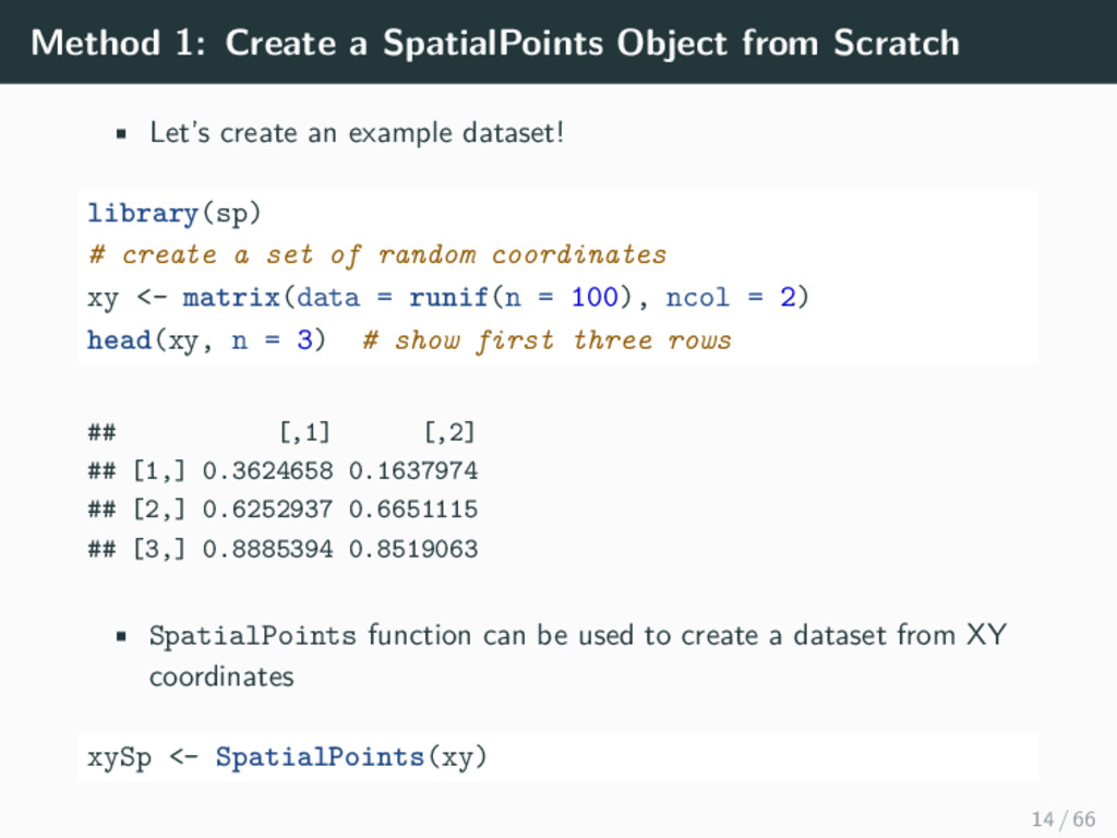
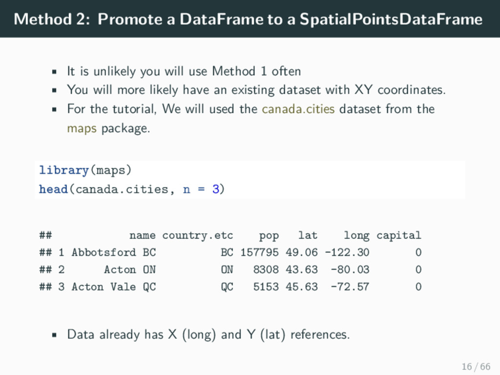
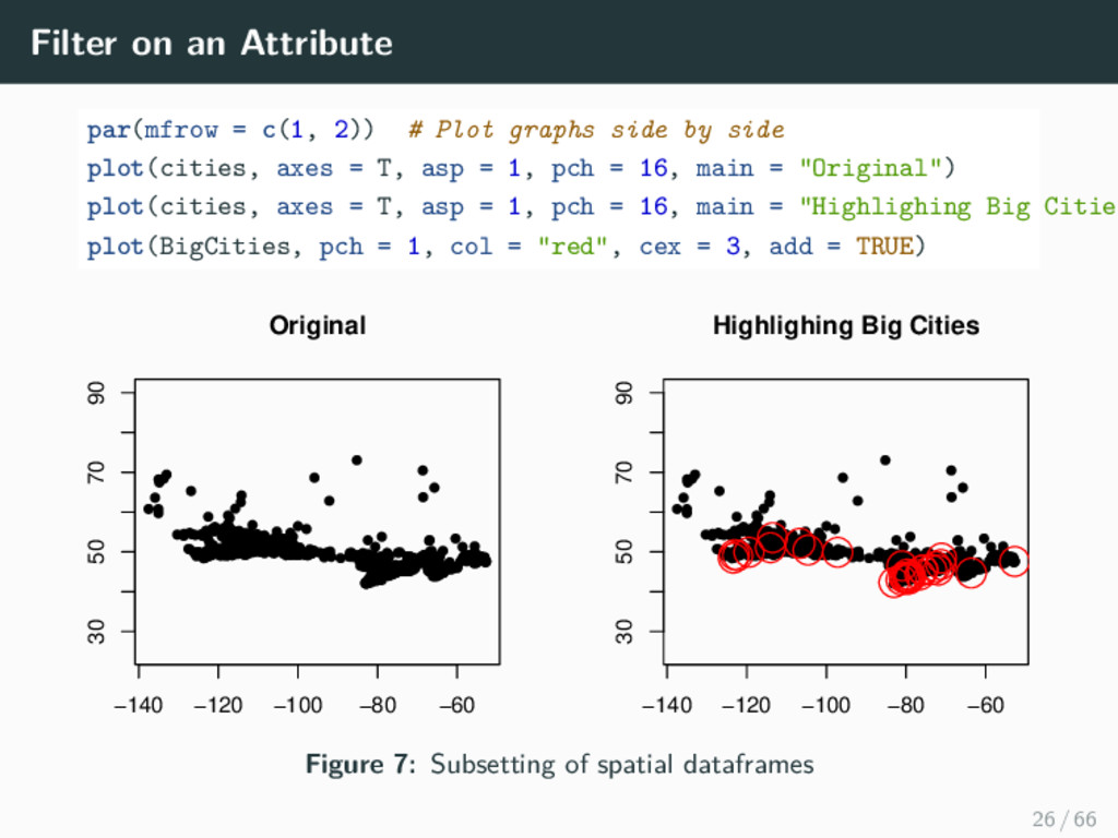
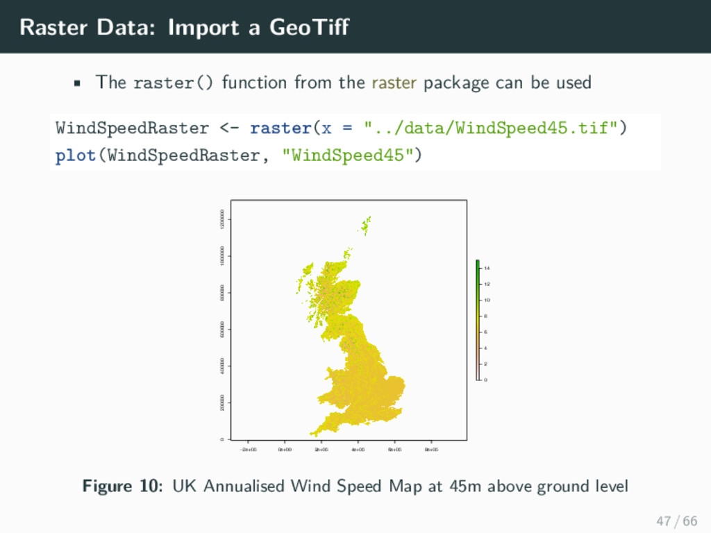
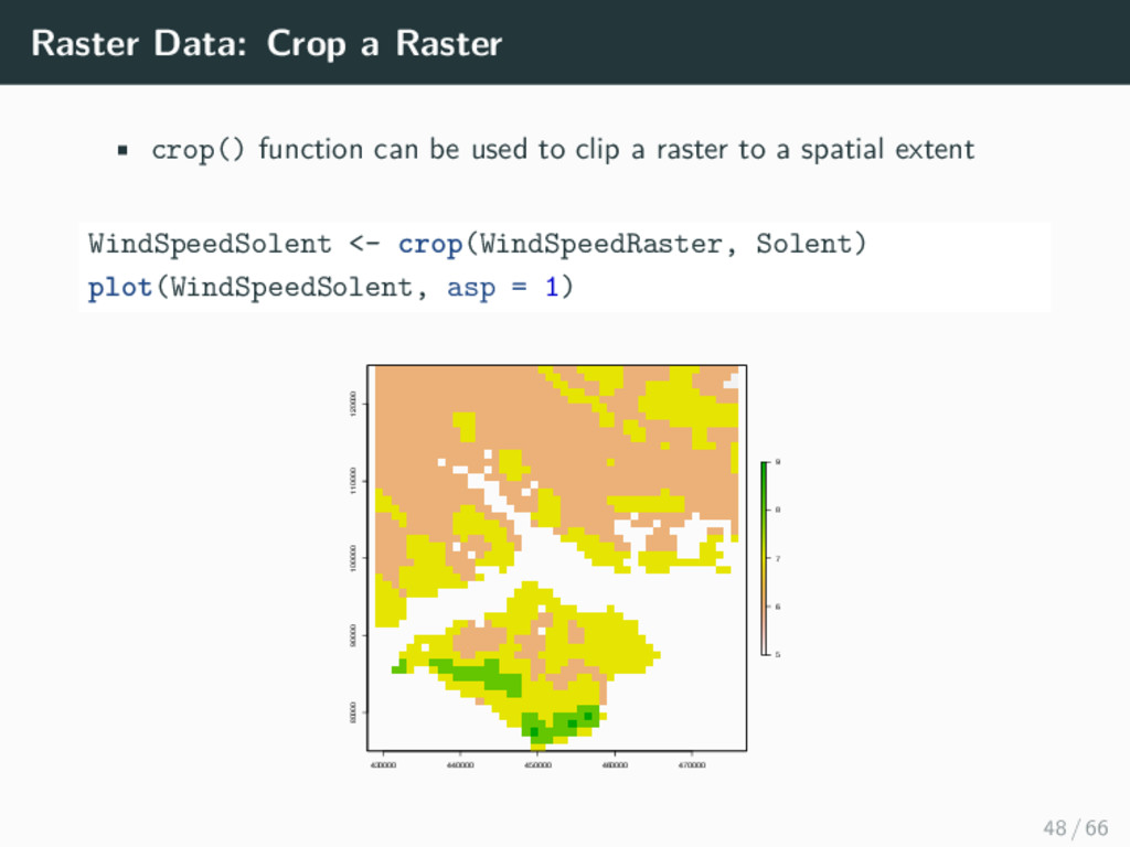
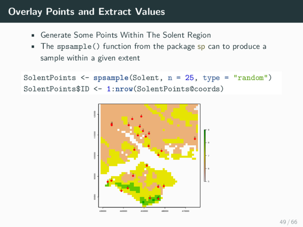
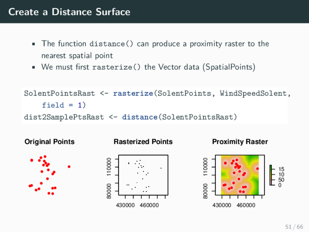
    FALSE) colnames(airports) <- c("ID", "name", "city", "country", "IATA_FAA", "ICAO", "lat", "lon", "altitude", "timezone", "DST") routes <- read.csv("https://raw.githubusercontent.com/jpatokal/openflights/master/data/routes.dat", header=F) colnames(routes) <- c("airline", "airlineID", "sourceAirport", "sourceAirportID", "destinationAirport", "destinationAirportID", "codeshare", "stops", "equipment") library(plyr) departures <- ddply(routes, .(sourceAirportID), "nrow") names(departures)[2] <- "flights" arrivals <- ddply(routes, .(destinationAirportID), "nrow") names(arrivals)[2] <- "flights" airportD <- merge(airports, departures, by.x = "ID", by.y = "sourceAirportID") airportA <- merge(airports, arrivals, by.x = "ID", by.y = "destinationAirportID") map <- get_map(location = 'Europe', zoom = 4, messaging = FALSE) # create the data set containing both departures and arrivals airportD$type <- "departures" airportA$type <- "arrivals" airportDA <- rbind(airportD, airportA) ggmap(map) + geom_point(aes(x = lon, y = lat, size = sqrt(flights)), data = airportDA, alpha = .5) + # panels according to type (departure/arrival) + ggtitle("Airports In Europe") + guides(fill=guide_legend(title="New Legend Title")) 60 / 66
  50. When to Use GIS vs. R? GIS • no mapping

    experience • one-off maps • serious cartography • your data live in a geodatabase R • no money for commercial software • need repeated analysis • integration with other analyses • development of new methods • working with large raster files 62 / 66
  51. Additional Resources Tutorials • http://rpubs.com/RobinLovelace/11869 • http://science.nature.nps.gov/im/datamgmt/statistics/r/advanced/ spatial.cfm • http://spatial.ly/r/

    • http://gis.stackexchange.com/questions/45327/ tutorials-to-handle-spatial-data-in-r • https://pakillo.github.io/R-GIS-tutorial/ R Spatial Cheatsheet • http://www.maths.lancs.ac.uk/~rowlings/Teaching/UseR2012/ cheatsheet.html • https://github.com/wegmann/RSdocs/releases/download/ May2014_spatial/AniMove_refcard.pdf 64 / 66
  52. Summary 1. Help you get to the point where you

    can do basic analysis or visualization 2. Point out some of the commonly-used packages for spatial data manipulation and analysis 3. Be a resource you can come back to 4. Provide Guidance on useful resources to use after the course Hopefully you have ticked a few of these boxes! 65 / 66