Upgrade to Pro — share decks privately, control downloads, hide ads and more …

Maps in Honduran Mosquitia for Collaborative Local Expressions of Territoriality and the Environment

Nathaniel V. KELSO
October 17, 2013
96

Maps in Honduran Mosquitia for Collaborative Local Expressions of Territoriality and the Environment

John Kelly, post-doctoral researcher
American Geographical Society/
University of Kansas

Nathaniel V. KELSO

October 17, 2013
Tweet

Transcript

  1. Maps in Honduran Mosquitia for Collaborative Local Expressions of Territoriality

    and the Environment John Kelly, post-doctoral researcher American Geographical Society/ University of Kansas [email protected]
  2. Sketch Mapping Building & Correcting Cartographic Shapefiles Participatory Research Mapping-GIS

    Cognitive Knowledge GPS Use & Coordinates Empowerment Field Research Training Technical Skills Community & Parcel Questionnaires
  3. Thrilled to be here. Obsessed with maps since I was

    six – like certain others at this conference, created a whole planet… but not here to talk about me, but to talk about maps critical to the land titling going on right now in the Mosquitia region of Honduras… Only a couple of slides…mainly walk you through the website, which has all the maps we’ll need to see… Brief background of people and situation (map and photos slides…reservas established in 1990s…rain forest, pine savanna, lots of lagoons and rivers, low population density…) – Honduran government, partly at urging of the World Bank, is standardizing its legal land ownership system…cadaster… (switch to index map online) (first, show the GoogleEarth kmz “locator map”) in Mosquitia, that includes granting clear title for the first time to local residents…. local residents meaning (mention the ethnic groups)… many have chosen to receive their titles not as individuals, nor as village-sized units like in much of Mexico, and not as single-tribe territories (like reservations here in the US), but rather as “territorial councils” – a new concept…bigger than a village, smaller than a county – legally based on proven “subsistence areas.” Two so far have title with published boundary coordinates…more coming soon…. I and my colleagues in Kansas and Honduras have developed a website which is key to this process, because it brings together in one place the foundational documents – mainly MAPS – which have allowed this evolving territorial system to become a reality, and the new maps. (Mention now who funds it…) There is great continuity here, because the same people who did the initial participatory research mapping in the 1990s which produced the local management plans for the reserves – indigenous leaders like Norvin Goff and Edgardo Benitez, and US-based geographers like Peter Herlihy – are the same ones leading this current effort. I apologize that the website’s maps and texts are in Spanish…but it should be pretty clear as I explain things what they show.
  4. So, the project had two cartographic tasks: 1. Make new

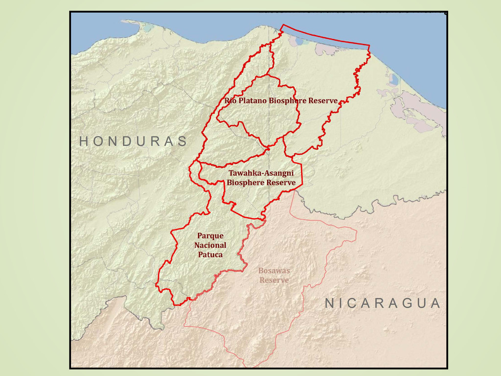
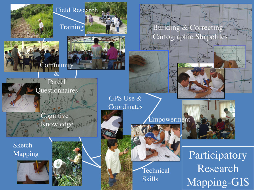
    maps which convey these subsistence zones – territories they have named, used, and occupied for centuries or longer – by combining the 1990s participatory mapping data with new things like land use and land cover from satellite imagery; 2. Make a website which organizes all this in a clear way – territorial forms (reservas, concejos…); precursor maps from the 1990s; and those new maps I just mentioned. Let me start by briefly going through how we digitized the 1990s map data. (Participatory slide) (Then, through website, pick one of the subzone maps)…beautiful, detailed, represent thousands of hours of work by hundreds of people in dozens of villages…but never digitized! So, we converted them into shapefiles. (Pick one of the RP new maps)….(take a few moments to drink in the design decisions…) designed to be viewed and printed as a poster, at 1:80,000…copies printed and distributed to local schools…not everyone has a computer or internet…. Now, you will notice that the website is just a very, very simple thing. I could apologize for that, but I won’t! Eventually, we will give users the option of some sort of web GIS portal – using SVG Mappetizer, or Open Street Map, or ArcGIS Online…we’ll see…but for now, it’s all about links to REAL MAPS (what some call “static maps”). They’re just pdf’s – so anyone can open them, pan, zoom…I hope I’m not alone when I say that there’s something to be said for “static maps,” where professionals like us have thought through the design, the scale, the symbology… And the website coding is simplicity itself…no CSS, no Drupal modules, just a jpeg with links from various pixel-areas –what coders call, funnily enough, an “image-map” – Clinton Administration-era coding…but this makes it easy for us our our indigenous partners to add and change stuff. And the index map itself had to be carefully thought out… I did it all just in ArcGIS10 – our team has Adobe Illustrator skills, but that wasn’t necessary – ArcGIS has come a long way in recent years – you can actually make a decent map these days! (…dwell for a bit on the design of the index map…)