Upgrade to Pro — share decks privately, control downloads, hide ads and more …

Location, Location, Location by Julia Grace

Location, Location, Location by Julia Grace

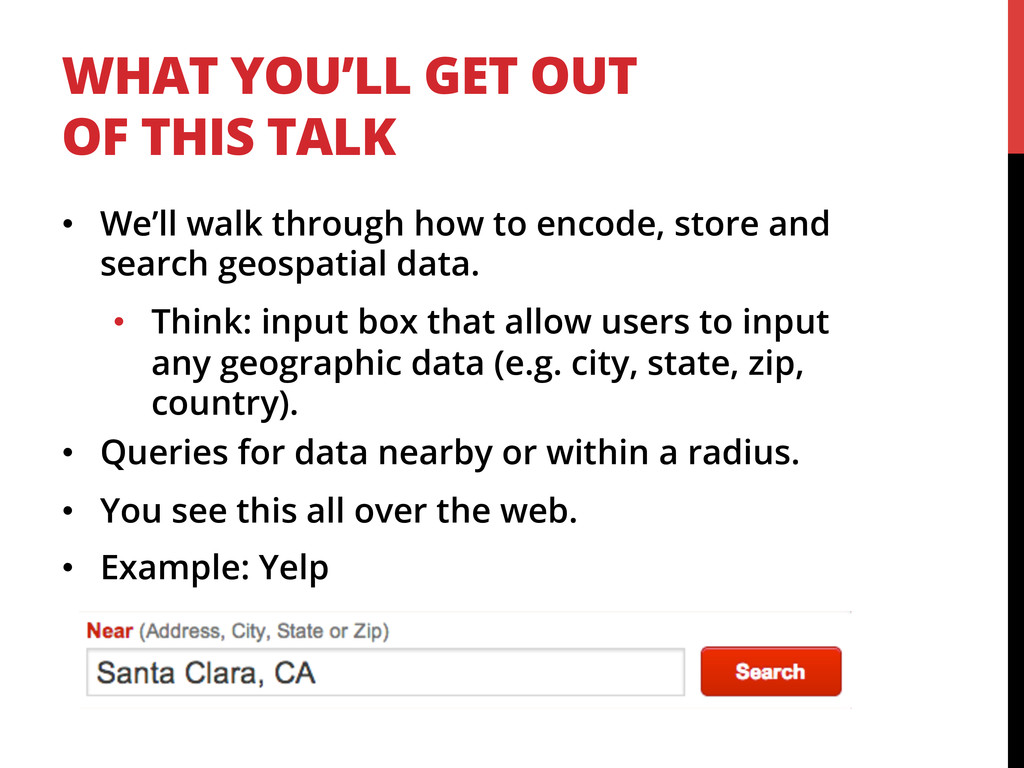
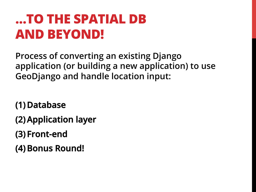
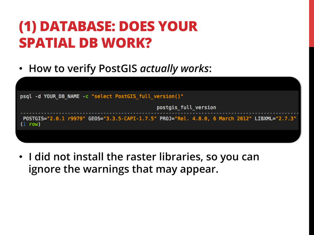
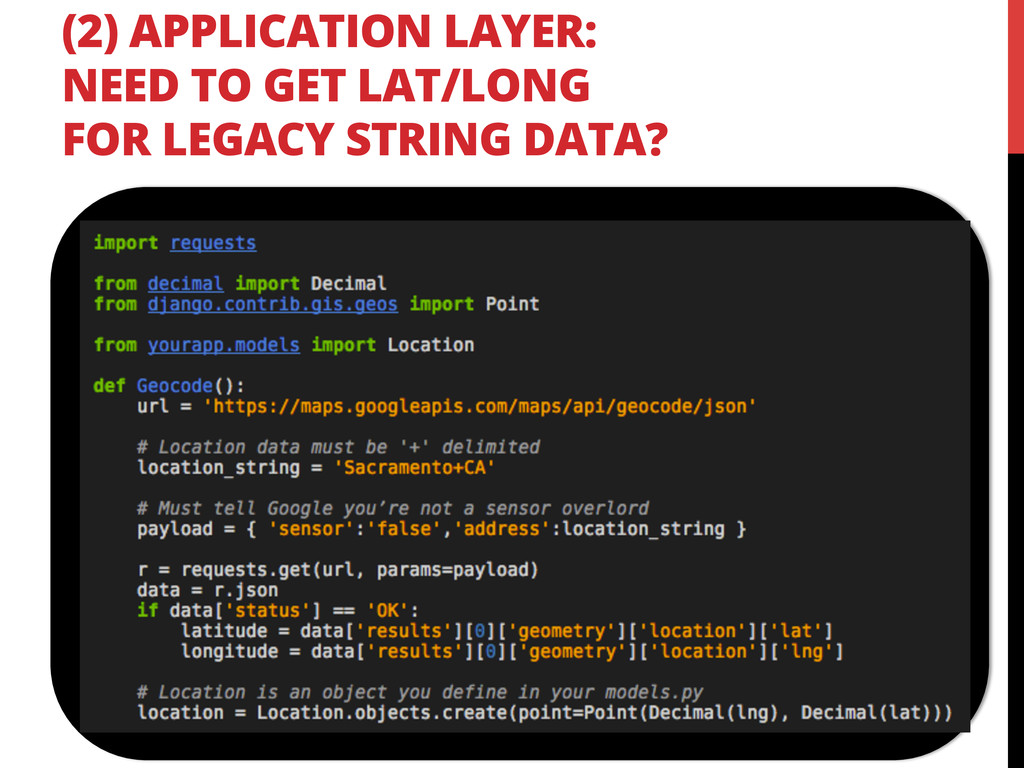
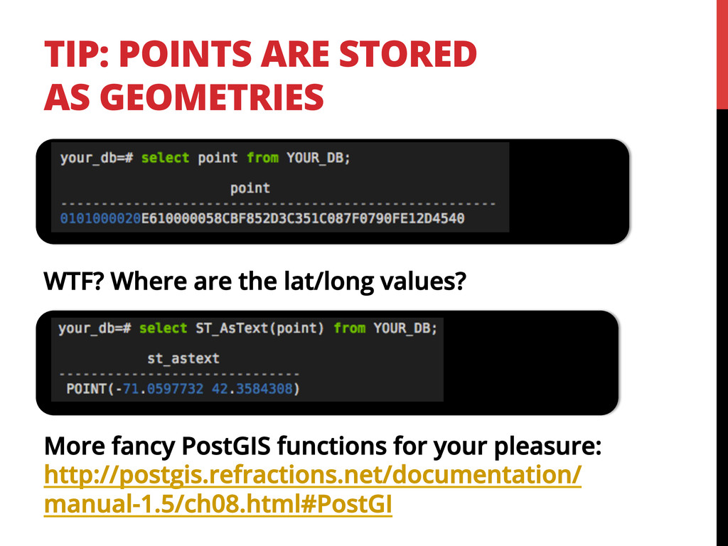
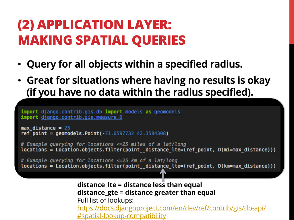
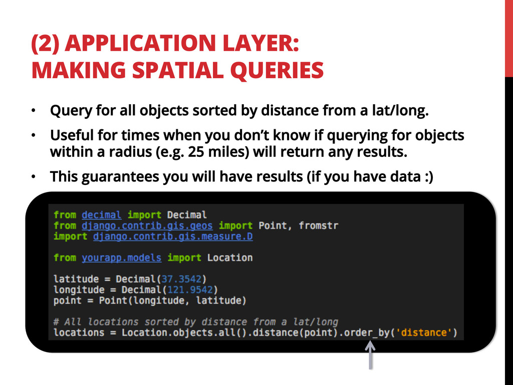
Are you building a Django application that needs to handle geographic location data? Are you unsure how to tackle using spatial databases, how to jump into using GeoDjango or how to allow users to query for data by, for example, zip code? I'll go over how to use GeoDjango, lessons learned in using spatial databases, and how I built an API exposing distance query functionality.

PyCon 2013

March 16, 2013
Tweet

More Decks by PyCon 2013

Other Decks in Programming

Transcript

  1. WHOAMI •  @jewelia •  1st Engineering hire at Tindie • 

    tindie.com •  “Etsy for Hardware Hackers” •  BS & MS in Computer Science •  Veteran of a few startups & IBM Research •  This talk goes over work I did in Fall 2012 at WeddingLovely.
  2. WHAT YOU’LL GET OUT OF THIS TALK •  We’ll walk

    through how to encode, store and search geospatial data. •  Think: input box that allow users to input any geographic data (e.g. city, state, zip, country). •  Queries for data nearby or within a radius. •  You see this all over the web. •  Example: Yelp
  3. BEFORE MOVING TO SPATIAL DB… •  Hard coded list of

    strings in a list shown in a dropdown. •  Cheap, easy and works most of the time.
  4. BE SMART (LISTS AIN’T ALL BAD) •  Not every application

    needs a spatial database and the ability to do distance lookups. •  Did I mention that lists are: •  Fast to implement. •  Need less infrastructure. •  Might get you 75% (or even 90%) of the way there.
  5. …BUT LISTS WERE NOT IDEAL FOR OUR USER- FACING SEARCH

    •  Good short term solution. Bad long term solution •  Alphabetically distant cities might be geographically close. Lake Tahoe and Sacramento are “close” enough that search results should contain objects in both locations.
  6. … JUST TO NOTE •  I had no idea how

    to do this when I started. •  No extensive experience with spatial databases or geocoding. •  Hopefully the lessons I learned will save you time/energy/cash money.
  7. …TO THE SPATIAL DB AND BEYOND! Process of converting an

    existing Django application (or building a new application) to use GeoDjango and handle location input: (1)  Database (2)  Application layer (3)  Front-end (4)  Bonus Round!
  8. (1) DATABASE: OPTIONS 1.  No spatial database and do the

    math ourselves. •  Store lat/long at decimals and mathematically compute distance between them using Haversine formula: 2.  Use a spatial database (e.g. PostGIS) and compute distances at the DB level (but then we might as well just be writing straight SQL): 3.  Spatial database + GeoDjango. •  GeoDjango = Django’s API for accessing geographic data and doing distance lookups (among other calculations) on that data. Haversine formula in Mathematica
  9. (1) DATABASE: INSTALL POSTGRESQL 9.2 •  We were running PostgreSQL

    9.1.3 on it’s on Ubuntu 12.04 LTS (precise). •  Decided to upgrade to 9.2 after struggling with 9.1.3 •  At the time (10/2012), 9.2 was not available via aptitude or apt-get. •  Reference: http://askubuntu.com/questions/186610/how- do-i-upgrade-to-postgres-9-2
  10. (1) DATABASE: INSTALL SPATIAL LIBRARIES •  List of needed libraries:

    https://docs.djangoproject.com/en/dev/ ref/contrib/gis/install/geolibs/ •  Versions matter! When using PostgreSQL 9.2 you must use (in this order): •  GEOS 3.3.3+ •  GDAL 1.9+ •  PostGIS 2.0+ •  Don’t install PostGIS before GEOS or face certain doom. •  Complete list of versions that play well: http://trac.osgeo.org/postgis/wiki/ UsersWikiPostgreSQLPostGIS
  11. (1) DATABASE: INSTALL PROPER DEPENDENCIES FOR YOUR OS Install PostGIS

    dependencies: Build GEOS 3.3.x: Build PostGIS: Reference (with detailed explanations I can’t fit here): http://trac.osgeo.org/postgis/wiki/UsersWikiPostGIS20Ubuntu1204src
  12. (1) DATABASE: LOAD UP THOSE SPATIAL LIBS 1.  Start PostgreSQL

    and create a DB (if you have an existing DB you’d like to use, you can skip this step). 2.  Create the spatial database template: 3.  Load PostGIS SQL routines: 4.  Enable users to alter spatial tables:
  13. (1) DATABASE: STACK SCRIPT TO INSTALL POSTGRES 9.2 + SPATIAL

    DB If you’re on Linode, here’s a stack script I wrote: http://www.linode.com/stackscripts/view/?StackScriptID=5425 (sorry for the eye test)
  14. (1) DATABASE: DOES YOUR SPATIAL DB WORK? •  How to

    verify PostGIS actually works: •  I did not install the raster libraries, so you can ignore the warnings that may appear.
  15. HOOK UP POSTGRES + POSTGIS TO DJANGO •  PostGIS 2.0

    doesn’t play well with Django: https://code.djangoproject.com/ticket/16455 •  Modify the PostGIS DB adapter •  Copy postgis/ directory from https://github.com/django/django/tree/master/ django/contrib/gis/db/backends/postgis to your local development directory. •  I copied it into a lib/postgis/ in my Django project. •  Update settings.py (next slide has example) to point to the new DB adapter. •  Make these changes: https://code.djangoproject.com/ attachment/ticket/16455/16455-r17171-v4.patch
  16. HOOK UP POSTGRES + POSTGIS TO DJANGO •  Example of

    settings.py pointing to local copy of the postgis DB adapter:
  17. GEOGRAPHY INTERLUDE •  Distance between 2 points on a plane

    is not computationally intensive to calculate. •  ..but the Earth isn’t flat and doing geometric calculations require more complex mathematics.
  18. (2) APPLICATION LAYER: FUN BEGINS •  Modifications to your existing

    models: ! geography=true uses spherical representation of the Earth instead of plane (flat) representation. For short distances plane will work (and is faster to compute) but for longer distances you should account for the curvature of the Earth or else you’re distances will inaccurate. More info: https://docs.djangoproject.com/en/dev/ref/contrib/gis/model-api/#geography
  19. (2) APPLICATION LAYER: POINT FIELD EXAMPLE •  Point = longitude/latitude

    representation of a point on Earth. •  Creating and saving a Point in Django ORM:
  20. INTERLUDE: WHAT IS GEOCODING •  Process of translating data (e.g.

    strings such as “94040” or “Santa Clara”) and finding the associated geographic coordinates such as latitude/longitude. •  Many public and free APIs to do this for you. •  One of most popular is Google’s Geocoding API: https://developers.google.com/maps/ documentation/geocoding/
  21. BOOM! •  Response: a lot of JSON data! •  You

    might not need all of it; I used: •  formatted_address •  location lat/long •  If you are going to be spending a lot of time reading JSON in a web browser, here are some plugins to make your life easier: •  https://twitter.com/jewelia/status/ 257997860451258369
  22. (2) APPLICATION LAYER: NEED TO GET LAT/LONG FOR LEGACY STRING

    DATA? •  What if you need to geocode legacy data (e.g. you stored “San Francisco, CA, USA)? •  Simple example using Google’s Geocoding API: https://developers.google.com/maps/ documentation/geocoding/ !
  23. TIP: POINTS ARE STORED AS GEOMETRIES WTF? Where are the

    lat/long values? More fancy PostGIS functions for your pleasure: http://postgis.refractions.net/documentation/ manual-1.5/ch08.html#PostGI
  24. (2) APPLICATION LAYER: MAKING SPATIAL QUERIES distance_lte = distance less

    than equal distance_gte = distance greater than equal Full list of lookups: https://docs.djangoproject.com/en/dev/ref/contrib/gis/db-api/ #spatial-lookup-compatibility •  Query for all objects within a specified radius. •  Great for situations where having no results is okay (if you have no data within the radius specified).
  25. (2) APPLICATION LAYER: MAKING SPATIAL QUERIES •  Query for all

    objects sorted by distance from a lat/long. •  Useful for times when you don’t know if querying for objects within a radius (e.g. 25 miles) will return any results. •  This guarantees you will have results (if you have data :)
  26. (3) FRONT END: GEOCODING USER INPUT •  Two options: Geocode

    client side or server side •  Client side •  You have to write JS. •  Many free geocoding APIs (like Google) rate limit you by IP address, so geocoding client side will likely mean you won’t get rate limited if you have a lot of different users. •  The terms of service of the Google Geocoding API require you to display a Google Map. •  Server side •  You get to write Python (this is PyCon…) •  You probably will be rate limited.
  27. (3) FRONT END: CLIENT SIDE GEOCODING USER INPUT •  Forms.py

    •  HTML template: HiddenInput because we are going to query for this data client side via Google Geocoding API.
  28. (3) FRONT END: GEOCODING USER INPUT •  Example based on

    https://developers.google.com/maps/documentation/javascript/geocoding •  Geocode client side, append the lat/long data to the form before submission:
  29. FINAL INTERLUDE •  Fancy things with middleware we tried at

    Tindie. •  Tindie has over 500 products from 200 sellers worldwide. •  Shipping rates can vary significantly based on country. •  Auto-detect country to show shipping rates? Robots shipped all around the world!
  30. BONUS: AUTO DETECT LOCATION THROUGH MIDDLEWARE •  There are services

    that map IP address to country. •  We used http://ipinfodb.com/ Pretty darn accurate….
  31. BONUS: AUTO DETECT LOCATION THROUGH MIDDLEWARE •  Add a Django

    Middleware to set the location in the session: •  If no location can be determined, default to US:
  32. THANK YOU This talk would not have been possible without

    feedback and input from these awesome people: •  Tracy Osborn •  Andrey Petrov •  Kenneth Love •  Lynn Root …and PyLadies!
  33. QUESTIONS? •  You can always find me at •  @jewelia

    •  [email protected] •  I also have stickers, lots of stickers