Upgrade to Pro — share decks privately, control downloads, hide ads and more …

EDC Workshop: Surveying & Mapping with Drones: How to Fuse UAV Data with Geospatial Data to Improve Onshore New Well Site Development, Pipeline & Utility Routes - Dr. Stacey Lyle, Research Scientist, Texas A&M University, College of Geoscience

Stone Fort Group
June 21, 2017
120

EDC Workshop: Surveying & Mapping with Drones: How to Fuse UAV Data with Geospatial Data to Improve Onshore New Well Site Development, Pipeline & Utility Routes - Dr. Stacey Lyle, Research Scientist, Texas A&M University, College of Geoscience

Stone Fort Group

June 21, 2017
Tweet

More Decks by Stone Fort Group

Transcript

  1. Energy Drone Coalition: Focused on the Business & Technology of

    Drones/UAS/UAV for Oil & Gas, Power and Chemical Markets How to fuse UAV data with Geospatial data to improve Onshore New Well Site Development Dr. Stacey D. Lyle, RPLS Texas A&M University Baseline Surveying- Binkley and Barfield Ashton Binkley Binkley and Barfield
  2. Where Energy & Drones Meet Stacey D. Lyle, PhD RPLS

    – Texas A&M University • Research Scientist [email protected] – Texas A&M University • Associate Research Scientist [email protected] – Baseline Surveying Corp – Binkley and Barfield • Chief Scientist [email protected] [email protected] – Cell 361-548-8852
  3. Where Energy & Drones Meet Ashton Binkley • Binkley and

    Barfield – Technical Solutions Manager • [email protected] • Texas A&M University – Research Assistant • a Houston Corporate Headquarters 1710 Seamist Drive Houston, TX 77008 Phone: 713-869-3433 Austin 3901 South Lamar Blvd., Suite 430 Austin, Texas 78704 Phone: 512-292-0006 Dallas 1801 Gateway Blvd., Suite 101 Richardson, TX 75080 Phone: 972-644-2800 Round Rock 2401 Double Creek Drive, Suite 200 Round Rock, Texas 78664 Phone: 512-292-0006 College Station 3452 Rock Prairie Road West College Station, TX 77845 Phone: 979-703-1809
  4. Where Energy & Drones Meet Workshop Take–A-Ways 1. Current UAV

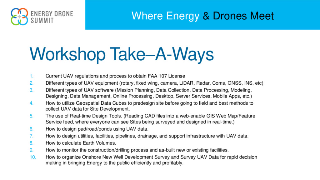
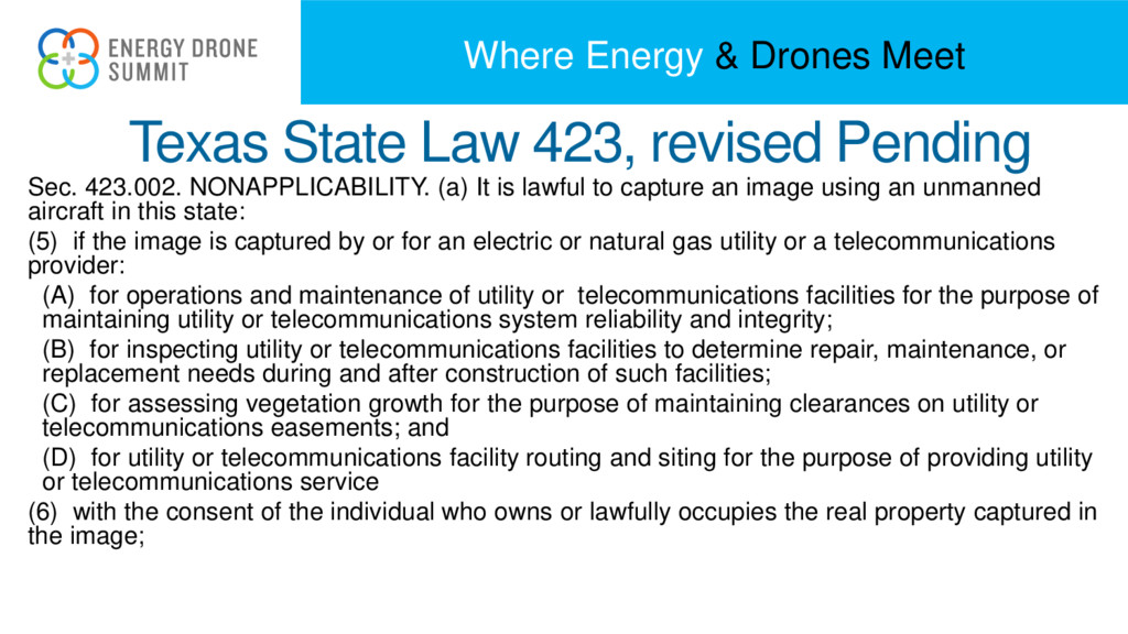
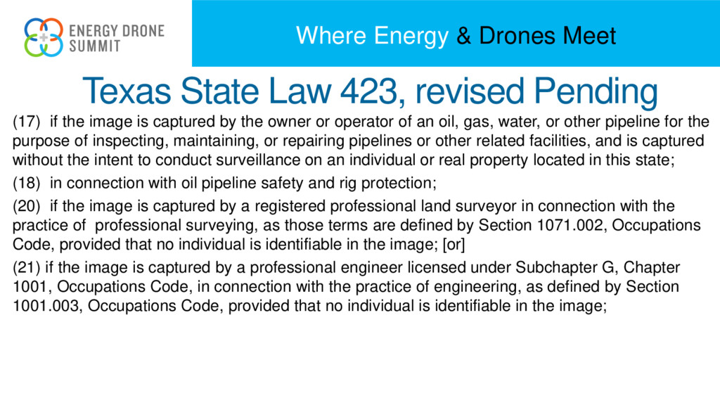
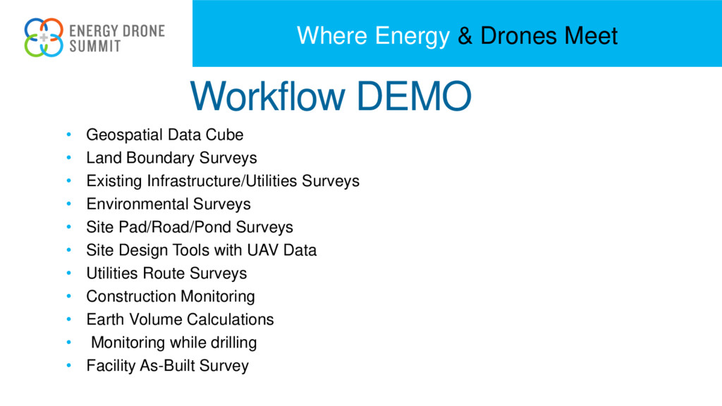
    regulations and process to obtain FAA 107 License 2. Different types of UAV equipment (rotary, fixed wing, camera, LiDAR, Radar, Coms, GNSS, INS, etc) 3. Different types of UAV software (Mission Planning, Data Collection, Data Processing, Modeling, Designing, Data Management, Online Processing, Desktop, Server Services, Mobile Apps, etc.) 4. How to utilize Geospatial Data Cubes to predesign site before going to field and best methods to collect UAV data for Site Development. 5. The use of Real-time Design Tools. (Reading CAD files into a web-enable GIS Web Map/Feature Service feed, where everyone can see Sites being surveyed and designed in real-time.) 6. How to design pad/road/ponds using UAV data. 7. How to design utilities, facilities, pipelines, drainage, and support infrastructure with UAV data. 8. How to calculate Earth Volumes. 9. How to monitor the construction/drilling process and as-built new or existing facilities. 10. How to organize Onshore New Well Development Survey and Survey UAV Data for rapid decision making in bringing Energy to the public efficiently and profitably.
  5. Where Energy & Drones Meet Terms • UAS-Unmanned Aircraft System

    • sUAS- small Unmanned Aircraft System • UAV- Unmanned Aerial Vehicle Commonly known as a drone.
  6. Where Energy & Drones Meet Fly for Fun Fly for

    Work Pilot Requirements No pilot requirements Must have Remote Pilot Airman Certificate Must be 16 years old Must pass TSA vetting Aircraft Requirements Must be registered if over 0.55 lbs. Must be less than 55 lbs. Must be registered if over 0.55 lbs. (online) Must undergo pre-flight check to ensure UAS is in condition for safe operation Location Requirements 5 miles from airports without prior notification to airport and air traffic control Class G airspace* Operating Rules Must ALWAYS yield right of way to manned aircraft Must keep the aircraft in sight (visual line-of-sight) UAS must be under 55 lbs. Must follow community-based safety guidelines Must notify airport and air traffic control tower before flying within 5 miles of an airport Must keep the aircraft in sight (visual line-of-sight)* Must fly under 400 feet* Must fly during the day* Must fly at or below 100 mph* Must yield right of way to manned aircraft* Must NOT fly over people* Must NOT fly from a moving vehicle* Example Applications Educational or recreational flying only Flying for commercial use (e.g. providing aerial surveying or photography services) Flying incidental to a business (e.g. doing roof inspections or real estate photography) Legal or Regulatory Basis Public Law 112-95, Section 336 – Special Rule for Model Aircraft FAA Interpretation of the Special Rule for Model Aircraft Title 14 of the Code of Federal Regulation (14 CFR) Part 107
  7. Where Energy & Drones Meet FAA License RP 107 •

    Remote Pilot – Small Unmanned Aircraft Systems Airman Certification Standards – FAA-S-ACS-10 – 14 CFR part 71; AC 107-2; FAA-H-8083-25; AIM
  8. Where Energy & Drones Meet 107 Requirments • An applicant

    to take the knowledge test must be at least 14 years of age. • Proper identification must be provided which contains the applicant's— 1. Photograph; 2. Signature; 3. Date of birth; 4. If the permanent mailing address is a post office box number, then the applicant must provide a current residential address.
  9. Where Energy & Drones Meet 14 CFR part 107 55

    lbs or less • Waivable sections of part 107 • Operation from a moving vehicle or aircraft (§ 107.25)* • Daylight operation (§ 107.29) • Visual line of sight aircraft operation (§ 107.31)* • Visual observer (§ 107.33) • Operation of multiple small unmanned aircraft systems (§ 107.35) • Yielding the right of way (§ 107.37(a)) • Operation over people (§ 107.39) • Operation in certain airspace (§ 107.41) • Operating limitations for small unmanned aircraft (§ 107.51)
  10. Where Energy & Drones Meet • Unmanned aircraft must weigh

    less than 55 lbs. (25 kg). • Visual line-of-sight (VLOS) only; the unmanned aircraft must remain within VLOS of the remote pilot in command and the person manipulating the flight controls of the small UAS. • Alternatively, the unmanned aircraft must remain within VLOS of the visual observer; unaided by any device other than corrective lenses. • Small unmanned aircraft may not operate over any persons not directly participating in the operation, not under a covered structure, and not inside a covered stationary • vehicle. • Daylight-only operations, or civil twilight (30 minutes before official sunrise to 30 minutes after official sunset, local time) with appropriate anti-collision lighting. • Must yield right of way to other aircraft. • May use visual observer (VO) but not required. • First-person view camera cannot satisfy “see-and-avoid” requirement but can be used as long as requirement is satisfied in other ways. • Maximum groundspeed of 100 mph (87 knots). • Maximum altitude of 400 feet above ground level (AGL) or, if higher than 400 feet AGL, remain within 400 feet of a structure. • Minimum weather visibility of 3 miles from control station. • Operations in Class B, C, D and E airspace are allowed with the required ATC permission. • Operations in Class G airspace are allowed without ATC permission. • No person may act as a remote pilot in command or VO for more than one unmanned aircraft operation at one time. • No operations from a moving aircraft. • No operations from a moving vehicle unless the operation is over a sparsely populated area. • No careless or reckless operations. • No carriage of hazardous materials. • FAA airworthiness certification is not required. However, the remote pilot in command must conduct a preflight check of the small UAS to ensure that it is in a condition for safe operation.
  11. Where Energy & Drones Meet Model Aircraft • Part 107

    does not apply to model aircraft that satisfy all of the criteria specified in section 336 of Public Law 112-95. • The rule codifies the FAA’s enforcement authority in part 101 by prohibiting model aircraft operators from endangering the safety of the NAS.
  12. Where Energy & Drones Meet Section 333 • By law,

    any aircraft operation in the national airspace requires a certificated and registered aircraft, a licensed pilot, and operational approval. • Petitions granted 5,551
  13. Where Energy & Drones Meet B4U Fly Smartphone App •

    A clear "status" indicator that immediately informs the operator about the current or planned location. For example, it shows flying in the Special Flight Rules Area around Washington, D.C. is prohibited. • Information on the parameters that drive the status indicator • A "Planner Mode" for future flights in different locations • Informative, interactive maps with filtering options • Links to other FAA UAS resources and regulatory information
  14. Where Energy & Drones Meet Sec. 423.002. NONAPPLICABILITY. (a) It

    is lawful to capture an image using an unmanned aircraft in this state: (5) if the image is captured by or for an electric or natural gas utility or a telecommunications provider: (A) for operations and maintenance of utility or telecommunications facilities for the purpose of maintaining utility or telecommunications system reliability and integrity; (B) for inspecting utility or telecommunications facilities to determine repair, maintenance, or replacement needs during and after construction of such facilities; (C) for assessing vegetation growth for the purpose of maintaining clearances on utility or telecommunications easements; and (D) for utility or telecommunications facility routing and siting for the purpose of providing utility or telecommunications service (6) with the consent of the individual who owns or lawfully occupies the real property captured in the image; Texas State Law 423, revised Pending
  15. Where Energy & Drones Meet Texas State Law 423, revised

    Pending (17) if the image is captured by the owner or operator of an oil, gas, water, or other pipeline for the purpose of inspecting, maintaining, or repairing pipelines or other related facilities, and is captured without the intent to conduct surveillance on an individual or real property located in this state; (18) in connection with oil pipeline safety and rig protection; (20) if the image is captured by a registered professional land surveyor in connection with the practice of professional surveying, as those terms are defined by Section 1071.002, Occupations Code, provided that no individual is identifiable in the image; [or] (21) if the image is captured by a professional engineer licensed under Subchapter G, Chapter 1001, Occupations Code, in connection with the practice of engineering, as defined by Section 1001.003, Occupations Code, provided that no individual is identifiable in the image;
  16. Where Energy & Drones Meet Basics of Photogrammetry and Remote

    Sensing • Spatial resolution is a term that refers to the number of pixels utilized in construction of a digital image. Images having higher spatial resolution are composed with a greater number of pixels than those of lower spatial resolution. Examples; 1 m pixels, 1 fts pixels, 0.25 ft pixels, ¼” pixels, etc Pixel Spatial Resolution  Height Above Ground
  17. Where Energy & Drones Meet DSLR or point-and-shoot, digital cameras

    use one of two sensor types: charged- coupled device (CCD) or complementary metal-oxide semiconductor (CMOS). Example: Cannon IXUS 990 12 MP Sensor Dimensions: - 6.16 x 4.62 mm or 650 pixel / mm - Pixel 1/650 mm or 0.00000153846 m - Focal Length 6.5 mm Flying Height 150 m 0.0065m/ 150 m = 0.00000153846m / DGND DGND = 0.0355m SF D d H a a a 1     Ha da Da
  18. Where Energy & Drones Meet Camera Configuration • Set shutter

    speed= Automatic. • Set ISO = as low as possible (minimum 100). • Set aperture = Automatic (Use sun shield if available) • Focus mode = Manual Focus on Infinity • No Digital Zoom, Resizing/cropping/rotation, Optical Stabilization, Auto Zoom, Flash Ref. Pix4D Getting Started and Manual; MicroStation ContextCapture Acquisition Guide
  19. Where Energy & Drones Meet 3D Stereo or Ortho Photo

    3D Overlap Ortho or Nadir- Camera pointing 90⁰ to the ground Overlap- (Base to Height Ratio) is the amount of common coverage between two images to make a 3D model along flight line Minimal 60% Ideal 80% Sidelap- is the amount of common coverage between two images on either side of flight lines
  20. Where Energy & Drones Meet Mission Planning – Ground Mapping

    Fly mission that covers subject area with complete Neat Model. Fly multiple times at different elevations. Fly with Camera tilt 15⁰ off Nadir. Overlap small missions on large areas. Ref. Pix4D 3D Flight Mission
  21. Where Energy & Drones Meet Mission Planning – Inspection Fly

    mission circling around structure. Fly at different elevations. Fly with Camera tilt 15⁰ off Nadir. Overlap small missions on large areas. Ref. Pix4D Ref. MicroStation
  22. Where Energy & Drones Meet Digital Orthography Photo and Structure

    from Motion • Structure from motion. Structure from motion (SfM) is a photogrammetric range imaging technique for estimating three- dimensional structures from two-dimensional image sequences that may be coupled with local motion signals. It is studied in the fields of computer vision and visual perception. • Digital photogrammetry, softcopy uses manual and automatic techniques for capturing, processing, and analyzing digital imagery— beginning either by scanning analog film or by direct digital image capture.
  23. Where Energy & Drones Meet LiDAR • LIDAR, which stands

    for Light Detection and Ranging, is a remote sensing method that uses light in the form of a pulsed laser to measure ranges (variable distances) to the Earth. • Types- Linear or Array • Swath = Flying Height to Field of Range 0-360⁰ • Scan rate= 30-1000k shots/sec • Accuracy = 0.01- 0.30 m
  24. Where Energy & Drones Meet Unmanned Aircraft System • Airframe-

    Body, Wings, Blades • Power- Combustion Engine, Electric Motor, Fuel, Battery, Gas, Wind • Computing- Flight Controller, Auto Pilot, Sensor Controller, Flight Controller Board(s) • Positioning- GPS, INS, Altimeter, Compass, SLAM, SoO, Radio-Ranging • Communication- Control, Tracking, Positioning • Sensors- Imaging, Scanning, Environmental, Communication
  25. Where Energy & Drones Meet Rotary vs. Fixed Wing Considerations

    • Project Outcomes/Application • Weight • Flight Duration • Wind • Mapping or Inspecting • Area of Coverage • Cost • GCP or No-GCP
  26. Where Energy & Drones Meet GNSS INS • GPS for

    Navigation and Control • GPS for Images – Direct Georeferencing – GCP – RTK – Post Processing Video • Image EXIF Header • INS for Rotation
  27. Where Energy & Drones Meet TG TG- EC Pix4D Drone

    Deploy Kespry Data Mapper Agisoft 2d3- Tacitview Cost Free Free1 $12,500 $299 /mo ? $299 /mo $3,500 $7,500 Online YES YES NO YES YES YES NO NO Desktop YES YES YES NO NO YES YES YES ALL Drones YES YES YES YES No YES YES YES Data Management YES YES YES YES YES YES YES YES GPS Processing YES YES NO NO NO NO NO NO Ground Control NO NO YES ? YES YES YES YES Orthomosaic YES YES YES YES YES YES YES YES Point Cloud YES YES YES YES YES YES YES YES NASAData Fuse YES YES NO NO NO NO NO NO Height Verify YES YES YES YES ? YES YES YES Unlimited Storage NO YES YES YES NO YES YES YES Shared Results YES YES NO NO NO NO NO NO Open-Source YES YES NO NO NO NO NO NO
  28. Where Energy & Drones Meet Workflow Data Collection 1. Drone

    2. Batteries 3. Targets –GCP 4. Base to Rover GPS 5. Mission 6. Learn the Controller 7. Upload the Mission to the Drone 8. Watch 9. Re-fly new height repeat
  29. Where Energy & Drones Meet Workflow DEMO • Geospatial Data

    Cube • Land Boundary Surveys • Existing Infrastructure/Utilities Surveys • Environmental Surveys • Site Pad/Road/Pond Surveys • Site Design Tools with UAV Data • Utilities Route Surveys • Construction Monitoring • Earth Volume Calculations • Monitoring while drilling • Facility As-Built Survey