Upgrade to Pro — share decks privately, control downloads, hide ads and more …

INSPIRE services with GeoServer and HALE, where are we?

INSPIRE services with GeoServer and HALE, where are we?

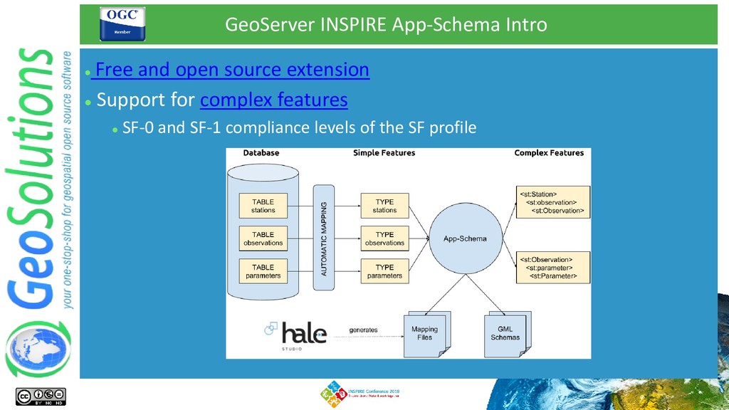
This presentation covers the progress made since last year's INSPIRE Conference with respect to the support for complex feature and the INSPIRE data specifications in GeoServer as well as the connection between HALE and GeoServer itself.

It also covers the ongoing work and the directions of future enhancements.

Simone Giannecchini

September 18, 2018
Tweet

More Decks by Simone Giannecchini

Other Decks in Programming

Transcript

  1. INSPIRE services with GeoServer and HALE, where are we? Ing.

    Simone Giannecchini Ing. Nuno Oliveira
  2. Quick Facts ⚫ Founded in late 2006 ⚫ Expertise •

    Image Processing, GeoSpatial Data Fusion • Java, Java Enterprise, C++, Python • JPEG2000, JPIP, Advanced visualization • Web Based Mashups, Mobile Solutions • OGC, ISO, INSPIRE Standards ⚫ Supporting/Developing FOSS4G projects ⚫ MapStore, GeoServer, GeoNetwork ⚫ CKAN, GeoNode ⚫ Clients ⚫ UN FAO (CIOK, FIGIS, NRL, FORESTRY, ESTG), UN WFP, World Bank, DLR, EUMETSAT, JRC, ARPAT, NATO CMRE ⚫ Private Companies all over the world
  3. Our Offer ⚫ Enterprise Support Services ⚫ Bug Fixing, Support,

    Customizations & New Features ⚫ 5 packages → different types of needs ⚫ Deployment Warranty ⚫ Deploy with confidence, we monitor and fix when needed ⚫ Professional Training ⚫ End-To-End Projects (Integration) ⚫ Tell me what you need, I’ll put it together for you ⚫ We take our core products and ⚫ Bend them, twist them, embed them ⚫ Hammer them to make clients happy ⚫ FOSS4G Software is core for us ⚫ Not simple use but develop and support
  4. GeoServer ⚫ http://www.geoserver.org ⚫ GeoSpatial enterprise gateway − Java Enterprise

    − Management and Dissemination of raster and vector data ⚫ Standards compliant −OGC WCS 1.0, 1.1.1 (RI), 2.0.1 → Download Services −OGC WFS 1.0, 1.1 (RI), 2.0.0 → Download Services −OGC WMS 1.1.1, 1.3.0 → View Services −OGC WPS 1.0.0 → Transformation Services −OGC CSW 2.0.2 → Discovery Services ⚫ Google Earth/Maps support −KML, GeoSearch, etc..
  5. Hale ⚫ Humboldt ALignment Editor (HALE) ⚫ Open Source visual

    editor for schema mappings ⚫ Main features: ⚫ Import source schema(s) and data ⚫ Shapefile, databases, XSD / XML, etc… ⚫ Import target schema(s) ⚫ XSD, databases, INSPIRE schemas ⚫ Transformations are: ⚫ Graphically designed ⚫ Interactively executed ⚫ Interactively viewed
  6. GeoServer INSPIRE Compliance Summary ⚫ INSPIRE Compliance ⚫ Available specific

    INSPIRE extension ⚫ Free and Open Source ⚫ New GUI Sections on services ⚫ Inject new elements in GetCapabilities ⚫ Download Services ⚫ OGC WFS 2.0 and GML 3.2.1 ⚫ OGC WCS 2.0.1 ⚫ View Services ⚫ OGC WMS 1.1.1, 1.3 ⚫ OGC WMTS 1.0.0 ⚫ Transformation Service ⚫ OGC WPS 1.0.0, gs:Reproject process
  7. GeoServer INSPIRE App-Schema Intro ⚫ Free and open source extension

    ⚫ Support for complex features ⚫ SF-0 and SF-1 compliance levels of the SF profile
  8. ⚫ No special schema requirement on the data sources !

    GeoServer INSPIRE App-Schema Intro App-Schema produces the expected GML output by transforming data on the fly !
  9. GeoServer INSPIRE App-Schema Intro ⚫ We only need to define

    the mappings between the data source and the target GML schema, App-Schema will do the rest:
  10. INSPIRE With GeoServer – HALE Interoperability ⚫ App-schema mappings are

    hard to define manually! ⚫ HALE GeoServer plugin to the rescue! ⚫ Create HALE alignment visually ⚫ Create GeoServer App-Schema mapping from it ⚫ Upload it automatically through GeoServer REST API Hey, no hands
  11. INSPIRE With GeoServer – HALE Interoperability ⚫ From Embedded (since

    HALE 2.9.4 ) plugin to Drop-in ⚫ From Hale 3.5.0 (to be released by the end of September) ⚫ Download the plugin ZIP file ⚫ Extract it in HALE's installation folder ⚫ Enjoy (yeah, sort of…)
  12. INSPIRE With GeoServer – Use Cases - BRGM ⚫ Bureau

    de Recherches Géologiques et Minières (BRGM) ⚫ Improve full text search performance ⚫ Millions of records ⚫ App-Schema Apache Solr Works with WMS Possibility to use Apache Solr as an external index !
  13. INSPIRE With GeoServer – Use Cases - INE ⚫ Statistics

    Portugal (INE) ⚫ Publishing several INSPIRE themes ⚫ The usual suspects Complex features in QGIS
  14. INSPIRE With GeoServer – Use Cases - NPRA ⚫ Norwegian

    Public Road Administration (NPRA) ⚫ DATEX II, traffic related data ⚫ Complex GeoJSON WMS and WFS
  15. INSPIRE With GeoServer – Known Issues ⚫ This repo will

    help keep the discussion in a single place! ⚫ Open GitHub repo for issues related to INSPIRE ⚫ Everyone can contribute !
  16. INSPIRE With GeoServer – Latest Improvements ⚫ App-Schema SQL improvements

    ⚫ Execute joins in the DBSM when possible ⚫ Performance improvements ⚫ Translate OGC filters to native SQL ⚫ Optimized SQL queries for nested properties Extend WMTS and WCS service configuration to support INSPIRE needs
  17. INSPIRE With GeoServer – Latest Improvements ⚫ Explicitly define the

    default geometry → supports nested geometries ⚫ Isolated workspaces concept ⚫ publishing the same complex feature type multiple times ⚫ no more need for several GeoServer instances ⚫ Handling of 1..N cardinality simple attributes without using a denormalized data source
  18. INSPIRE With GeoServer – Upcoming Improvements ⚫ Improve stored queries

    support ⚫ Fix known bugs ⚫ Performance improvements (always !) ⚫ Improve SQL encoding of filters on nested properties