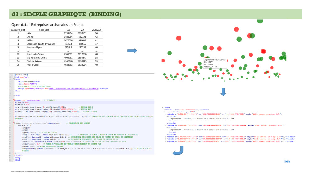
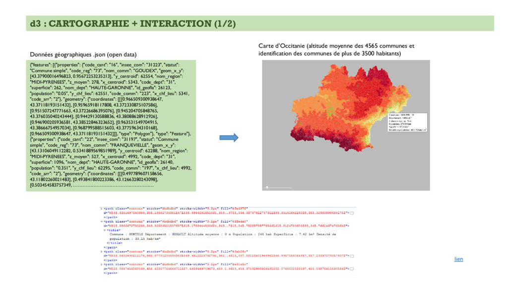
"insee_com": "31223", "statut": "Commune simple", "code_reg": "73", "nom_comm": "GOUDEX", "geom_x_y": [43.37900016496823, 0.95672253235213], "y_centroid": 62554, "nom_region": "MIDI-PYRENEES", "z_moyen": 278, "x_centroid": 5343, "code_dept": "31", "superficie": 262, "nom_dept": "HAUTE-GARONNE", "id_geofla": 26123, "population": "0.05", "y_chf_lieu": 62551, "code_comm": "223", "x_chf_lieu": 5341, "code_arr": "2"}, "geometry": {"coordinates": [[[0.966509300938647, 43.37118193151432], [0.95965918117808, 43.372330875107586], [0.951507247771663, 43.37226686395076], [0.945204705848765, 43.376035040243444], [0.94429130588836, 43.38088628912926], [0.946900205936581, 43.38522846323652], [0.963531549704915, 43.38666754957034], [0.968799588515603, 43.37759634310168], [0.966509300938647, 43.37118193151432]]], "type": "Polygon"}, "type": "Feature"}, {"properties": {"code_cant": "22", "insee_com": "31197", "statut": "Commune simple", "code_reg": "73", "nom_comm": "FRANQUEVIELLE", "geom_x_y": [43.13106049112282, 0.5341889569851989], "y_centroid": 62288, "nom_region": "MIDI-PYRENEES", "z_moyen": 527, "x_centroid": 4992, "code_dept": "31", "superficie": 1096, "nom_dept": "HAUTE-GARONNE", "id_geofla": 26140, "population": "0.351", "y_chf_lieu": 62295, "code_comm": "197", "x_chf_lieu": 4992, "code_arr": "2"}, "geometry": {"coordinates": [[[0.497789607158656, 43.11802260021483], [0.493841800223386, 43.12663280243098], [0.503454583757349, …………………………………………… Données géographiques .json (open data) Carte d’Occitanie (altitude moyenne des 4565 communes et identification des communes de plus de 3500 habitants) lien