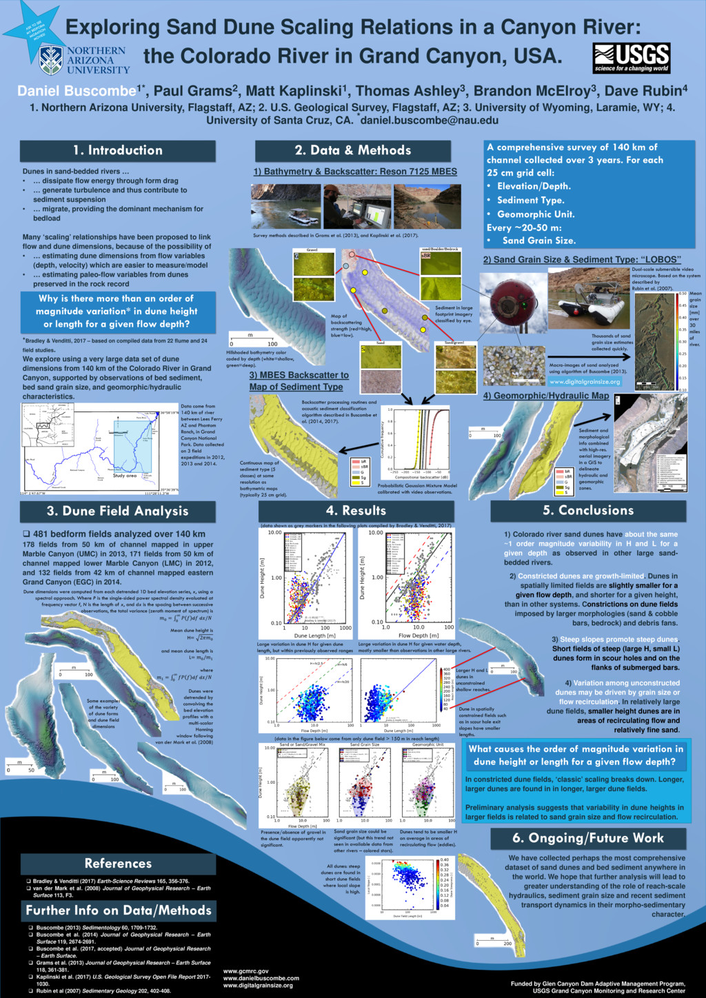
through form drag • … generate turbulence and thus contribute to sediment suspension • … migrate, providing the dominant mechanism for bedload Many ‘scaling’ relationships have been proposed to link flow and dune dimensions, because of the possibility of • … estimating dune dimensions from flow variables (depth, velocity) which are easier to measure/model • … estimating paleo-flow variables from dunes preserved in the rock record *Bradley & Venditti, 2017 – based on compiled data from 22 flume and 24 field studies. We explore using a very large data set of dune dimensions from 140 km of the Colorado River in Grand Canyon, supported by observations of bed sediment, bed sand grain size, and geomorphic/hydraulic characteristics. 1. Introduction 481 bedform fields analyzed over 140 km 178 fields from 50 km of channel mapped in upper Marble Canyon (UMC) in 2013, 171 fields from 50 km of channel mapped lower Marble Canyon (LMC) in 2012, and 132 fields from 42 km of channel mapped eastern Grand Canyon (EGC) in 2014. 1) Bathymetry & Backscatter: Reson 7125 MBES 2. Data & Methods 3. Dune Field Analysis A comprehensive survey of 140 km of channel collected over 3 years. For each 25 cm grid cell: • Elevation/Depth. • Sediment Type. • Geomorphic Unit. Every ~20-50 m: • Sand Grain Size. References Bradley & Venditti (2017) Earth-Science Reviews 165, 356-376. van der Mark et al. (2008) Journal of Geophysical Research – Earth Surface 113, F3. Exploring Sand Dune Scaling Relations in a Canyon River: the Colorado River in Grand Canyon, USA. Daniel Buscombe1*, Paul Grams2, Matt Kaplinski1, Thomas Ashley3, Brandon McElroy3, Dave Rubin4 1. Northern Arizona University, Flagstaff, AZ; 2. U.S. Geological Survey, Flagstaff, AZ; 3. University of Wyoming, Laramie, WY; 4. University of Santa Cruz, CA. *
[email protected] Funded by Glen Canyon Dam Adaptive Management Program, USGS Grand Canyon Monitoring and Research Center 2) Sand Grain Size & Sediment Type: “LOBOS” 3) MBES Backscatter to Map of Sediment Type Further Info on Data/Methods Buscombe (2013) Sedimentology 60, 1709-1732. Buscombe et al. (2014) Journal of Geophysical Research – Earth Surface 119, 2674-2691. Buscombe et al. (2017, accepted) Journal of Geophysical Research – Earth Surface. Grams et al. (2013) Journal of Geophysical Research – Earth Surface 118, 361-381. Kaplinski et al. (2017) U.S. Geological Survey Open File Report 2017- 1030. Rubin et al (2007) Sedimentary Geology 202, 402-408. Study area Backscatter processing routines and acoustic sediment classification algorithm described in Buscombe et al. (2014, 2017). Survey methods described in Grams et al. (2013), and Kaplinski et al. (2017). 4. Results 6. Ongoing/Future Work Dual-scale submersible video microscope. Based on the system described by Rubin et al. (2007). Sediment and morphological info combined with high-res. aerial imagery in a GIS to delineate hydraulic and geomorphic zones. Why is there more than an order of magnitude variation* in dune height or length for a given flow depth? 5. Conclusions 1) Colorado river sand dunes have about the same ~1 order magnitude variability in H and L for a given depth as observed in other large sand- bedded rivers. 2) Constricted dunes are growth-limited. Dunes in spatially limited fields are slightly smaller for a given flow depth, and shorter for a given height, than in other systems. Constrictions on dune fields imposed by larger morphologies (sand & cobble bars, bedrock) and debris fans. 3) Steep slopes promote steep dunes. Short fields of steep (large H, small L) dunes form in scour holes and on the flanks of submerged bars. 4) Variation among unconstructed dunes may be driven by grain size or flow recirculation. In relatively large dune fields, smaller height dunes are in areas of recirculating flow and relatively fine sand. 4) Geomorphic/Hydraulic Map Continuous map of sediment type (5 classes) at same resolution as bathymetric maps (typically 25 cm grid). Probabilistic Gaussian Mixture Model calibrated with video observations. Map of backscattering strength (red=high, blue=low). Hillshaded bathymetry color coded by depth (white=shallow, green=deep). Macro-images of sand analyzed using algorithm of Buscombe (2013). www.digitalgrainsize.org Sediment in large footprint imagery classified by eye. Thousands of sand grain size estimates collected quickly. Data come from 140 km of river between Lees Ferry AZ and Phantom Ranch, in Grand Canyon National Park. Data collected on 3 field expeditions in 2012, 2013 and 2014. Mean grain size [mm] over 30 miles of river. Large variation in dune H for given dune length, but within previously observed ranges Large variation in dune H for given water depth, mostly smaller than observations in other large rivers. Dune in spatially constrained fields such as in scour hole exit slopes have smaller lengths. Larger H and L dunes in unconstrained shallow reaches. Presence/absence of gravel in the dune field apparently not significant. Sand grain size could be significant (but this trend not seen in available data from other rivers – colored stars). Dunes tend to be smaller H on average in areas of recirculating flow (eddies). What causes the order of magnitude variation in dune height or length for a given flow depth? In constricted dune fields, ‘classic’ scaling breaks down. Longer, larger dunes are found in in longer, larger dune fields. Preliminary analysis suggests that variability in dune heights in larger fields is related to sand grain size and flow recirculation. www.gcmrc.gov www.danielbuscombe.com www.digitalgrainsize.org All dunes: steep dunes are found in short dune fields where local slope is high. Dune dimensions were computed from each detrended 1D bed elevation series, x, using a spectral approach. Where P is the single-sided power spectral density evaluated at frequency vector f, N is the length of x, and dx is the spacing between successive observations, the total variance (zeroth moment of spectrum) is 0 = ∫ 0 ∞ d d/ Mean dune height is H= 20 and mean dune length is L= 0 /1 where 1 = ∫ 0 ∞ d d/ Dunes were detrended by convolving the bed elevation profiles with a multi-scalar Hanning window following van der Mark et al. (2008) (data shown as grey markers in the following plots compiled by Bradley & Venditti, 2017) We have collected perhaps the most comprehensive dataset of sand dunes and bed sediment anywhere in the world. We hope that further analysis will lead to greater understanding of the role of reach-scale hydraulics, sediment grain size and recent sediment transport dynamics in their morpho-sedimentary character. Some examples of the variety of dune forms and dune field dimensions (data in the figure below come from only dune field > 150 m in reach length)