Upgrade to Pro — share decks privately, control downloads, hide ads and more …

SCWCSU GIS Service - Supporting CCGs

Avatar for Health GI Health GI
June 22, 2015
85

SCWCSU GIS Service - Supporting CCGs

Avatar for Health GI

Health GI

June 22, 2015
Tweet

Transcript

  1. GIS Support for Clinical Commissioning Groups (CCGs) Trevor Foster GIS

    & Primary Care Manager South, Central and West Commissioning Support
  2. South, Central & West Commissioning Support (SCWCS) GIS and Mapping

    Service • What is GIS? • About us • How GIS is used in healthcare - Example analysis and maps • Case study example – Hospital Service Review (Stroke services) • Demonstration - HealthGIS Maps (online mapping portal) – BNSSSG Primary Care project – MapCat (map catalogue) – Map Builder
  3. What is GIS? • Geographic Information System (Wikipedia): – “GIS

    is the merging of cartography, statistical analysis, and database technology” – “integrates, stores, analyses and displays geographic information for informing decision making” • Data management and preparation – maps and health data • Geocoding/georeferencing • Analysis – statistical, spatial • Thematic styling • Layers; Admin boundaries, road network, sites, people
  4. Helps support business decision making Support around: Using: • Contract

    management • Performance monitoring • Service review/development • Public Health • Commissioning • Estate planning & facilities • Emergency planning • Travel & Access analysis • Ordnance Survey digital data/maps • Population statistics • Patient distribution • GP and Hospital activity data ------------------------------ • MapInfo Professional • RouteFinder • BaseMap TRACC • Cadcorp SIS “Everything happens somewhere” “80% of data has a geographical component”
  5. SCWCSU - GIS and Mapping Service • Formerly Avon IM&T

    Consortium – 2013 moved to South West CSU – 2015 moved to South, Central and West CSU • Supporting HA/PCTs/CCGs and others for 20 years • Ordnance Survey licensing - OpenData & PSMA (2010/11) • OS Multi-Client Contractor License (2011) • Growth in demand from wider NHS • Developed team of specialised GIS analysts/developers • Traditional GIS analysis and mapping • HealthGIS Maps (on-line mapping portal) • Licensed partner with Ordnance Survey (2014)
  6. • CCGs: Bristol, North Somerset, South Glos, Somerset, West Hants,

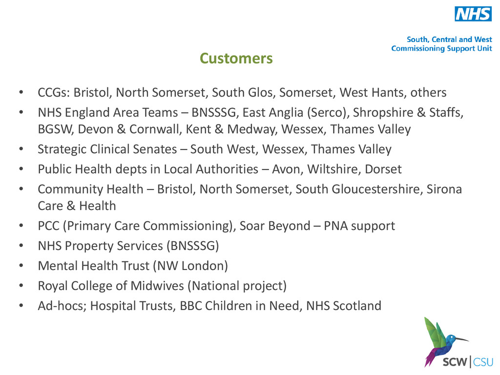
    others • NHS England Area Teams – BNSSSG, East Anglia (Serco), Shropshire & Staffs, BGSW, Devon & Cornwall, Kent & Medway, Wessex, Thames Valley • Strategic Clinical Senates – South West, Wessex, Thames Valley • Public Health depts in Local Authorities – Avon, Wiltshire, Dorset • Community Health – Bristol, North Somerset, South Gloucestershire, Sirona Care & Health • PCC (Primary Care Commissioning), Soar Beyond – PNA support • NHS Property Services (BNSSSG) • Mental Health Trust (NW London) • Royal College of Midwives (National project) • Ad-hocs; Hospital Trusts, BBC Children in Need, NHS Scotland Customers
  7. Contract management • GP contract map • Where GIS started

    in Avon – mid 90’s • Patient details from ‘Exeter System’ registration database • Postcodes • Graduated symbols thematic • Options to include age/sex
  8. • 2012 DH initiative • Surgery location • Contractual area

    • Registered patients • Drive-time areas (peak-time) for (10, 15 minutes) • No. & % patients in each area GP Outer Areas
  9. Service development (GP) • Number of overlapping practice areas across

    area • Aim is to provide choice of at least 2 practices to patients
  10. Service development (GP) • Planned housing development areas • Information

    from Local Authority • 5,700 + 2,400 houses (approx 19,000 patients) over 20 years
  11. Service development (GP) • Residential housing development • Option for

    proposed District Centre (GP surgery) • Walking access times to nearest GP surgeries
  12. Equality Impact Assessment • Maps and information to support assessments

    • Area and registered patients • Deprivation • Travel access (drive, walk, PT) • Practice coverage • Profile reports
  13. Pharmaceutical Needs Assessment (PNA) • Mandatory HWB/CCG requirement • Annual

    refresh & publish • Supports HWB, CCG, PH planning and development • Maps – Pharmacy contractors – 1.6km buffers – Travel access; drive-times (average, peak, off-peak), public transport, walking. Population numbers by travel time zones – Opening times and availability – Demographic maps; deprivation, population density, ethnicity – Lifestyle maps; obesity (adults, children), smoking prevalence
  14. PNA

  15. • Quarterly/monthly performance monitoring reports • Child Vaccinations & Immunisations,

    Cancer screening • RAG (Red, Amber, Green) traffic lights for targets achievement Performance monitoring
  16. • CQUIN (Commissioning for Quality & Innovation) scheme – Equity

    of Access • Ambulance response times “A8” performance by division • Top 10 through to Bottom 10 performing divisions • “identify 10 rural areas with significant variance against the performance in the urban centres” Performance monitoring
  17. • Somerset GP Out of Hours • Service provider sites

    • No. calls by type • Deprivation • Population density Commissioning Services
  18. • Service reconfiguration • Impact assessment after new community hospital

    opened • Change in Emergency Dept. attendance rates in South Bristol Commissioning Services
  19. • Orthodontic Choice analysis • Service provider sites • Patient

    travel to treatment site Commissioning Services
  20. • Orthodontic Choice analysis • Patients treated at nearest site

    • Patients not treated at nearest site Commissioning Services
  21. • Prescribing by GP practice • Bi-variate presentation • Practice

    population (shades of blue) • Number of cases (symbol size) Prescribing
  22. • Further information? • Contact us at - [email protected] [email protected]

    • Telephone: 0117 900 2490 • Visit our website: http://www.healthgis.nhs.uk http://nww.healthgis.nhs.uk (NHS staff only)