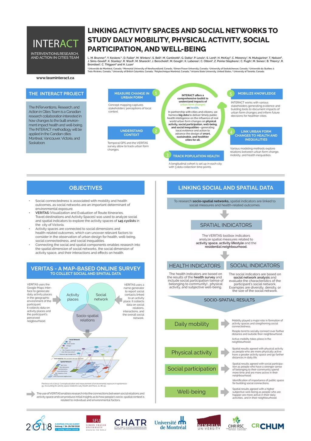
POPULATION HEALTH LINK URBAN FORM CHANGES TO HEALTH AND INEQUALITIES LINKING ACTIVITY SPACES AND SOCIAL NETWORKS TO STUDY DAILY MOBILITY, PHYSICAL ACTIVITY, SOCIAL PARTICIPATION, AND WELL-BEING INTERACT INTERVENTIONS,RESEARCH, AND ACTION IN CITIES TEAM L. M. Brunner³, Y. Kestens*1, D. Fuller2, M. Winters3, S. Bell4, M. Cantinotti5, G. Datta4, P. Lewis4, S. Lord4, H. McKay6, C. Morency7, N. Muhajarine4, T. Nelson8, J. Sims-Gould6, K. Stanley4, R. Wasfi1, M. Shareck9, J. Berscheid4, M. Gough4, K. Laberee3, C. Ottoni6, Z. Poirier Stephens1, C. Pugh3, M. Sones3, B. Thierry1, R. Brondeel1, C. Thigpen8 and H. Luan2 1 Université de Montréal, Canada, 2 Memorial University of Newfoundland, Canada, 3 Simon Fraser University, Canada, 4 University of Saskatchewan, Canada, 5 Université du Québec à Trois-Rivières, Canada, 6 University of British Columbia, Canada, 7 Polytechnique Montréal, Canada, 8 Arizona State University, United States, 9 University of Toronto, Canada A longitudinal cohort is set up in each city with 3 data collection time points. Various modeling methods explore relations between urban form change, mobility, and health inequalities. INTERACT works with various stakeholders generating evidence and building tools to document impacts of urban form changes and inform future decisions for healthier cities. Concept mapping captures stakeholders’ perceptions of local context. INTERACT offers a comprehensive toolkit to understand impacts of urban form changes on health. In partnership with cities and citizens, we harness big data to deliver timely public health intelligence on the influence of real world urban form changes on physical activity, social participation, well-being, and social inequalities—generating local evidence and action to advance the design of smart, sustainable, and healthier cities for all. THE INTERACT PROJECT The INTerventions, Research, and Action in Cities Team is a Canadian research collaboration interested in how changes to the built environ- ment impact health and well-being. The INTERACT methodlogy will be applied in the Candian cities Montreal, Vancouver, Victoria, and Saskatoon. OBJECTIVES • Social connectedness is associated with mobility and health outcomes, as social networks are an important determinant of environmental exposure. • VERITAS (Visualization and Evaluation of Route Itineraries, Travel destinations and Activity Spaces) was used to analyze social and spatial indicators to explore the activity spaces of 145 cyclists in the city of Victoria. • Activity spaces are connected to social dimensions and health-related outcomes, which can uncover relevant factors to consider in the observation of urban design for health, well-being, social connectedness, and social inequalities. • Connecting the social and spatial components enables research into the spatial dimension of social networks, the social dimension of activity space, and their interactions and effects on health. VERITAS - A MAP-BASED ONLINE SURVEY TO COLLECT SOCIAL AND SPATIAL DATA Activity places Social network Socio-spatial relations LINKING SOCIAL AND SPATIAL DATA 5 Temporal GPS and the VERITAS survey allow to track urban form changes. To research socio-spatial networks, spatial indicators are linked to social measures and health-related outcomes. SPATIAL INDICATORS The VERITAS toolbox indicators analyze spatial measures related to activity space, activity lifestyle and the residential neighbourhood. HEALTH INDICATORS SOCIAL INDICATORS The social indicators are based on social network analysis and evaluate the characteristics of the participant’s social network. Examples are diversity, density, or the size of the social network. VERITAS uses a name generator to report social contacts linked to an activity place. It collects data on social relations, interactions, and the overall social network. VERITAS uses the Google Maps Inter- face to geolocate daily activity places in the geographic environment of the participant. It collects data on activity places and the participant’s perceived neigbourhood. Perchoux et al (2013): Conceptualization and measurement of environmental exposure in epidemiolo- gy: Accounting for activity space related to saily Health and Place, 21, 86-93. Daily mobility Well-being Social participation Physical activity Mobility played a major role in formation of activity spaces and stregthening social connectedness. Spatial results agreed with physical activity as people who are more physically active have a greater activity space and go farther distances in daily life. Spatial results agreed with social participa- tion as people who have a stronger sense of belonging to their community spend more time and are more active in their neighbourhood. Spatial results agreed with a higher subjective well-being as people who are happier are more active in their daily activities, and in their neighbourhood. The health indicators are based on the results of the health survey and include social participation (sense of belonging to community) , physical activity, and subjective well-being. 4 3 2 1 www.teaminteract.ca SOCIO-SPATIAL RESULTS The use of VERITAS enables research into the connections between social relations and activity space and can produce initial insights as to how people’s socio-spatial context is related to individual and environmental factors. Active mobility takes place in the neighbourhood. People tend to socially connect over farther distance and outside their neighbourhood. Identification of importance of public space for building social connections.