Upgrade to Pro — share decks privately, control downloads, hide ads and more …

Data access and data extraction services within the Land Imagery Portal

Data access and data extraction services within the Land Imagery Portal

Models for scientific exploitation of EO Data - Frascati - October 12th 2012

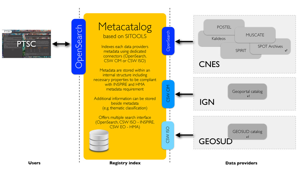
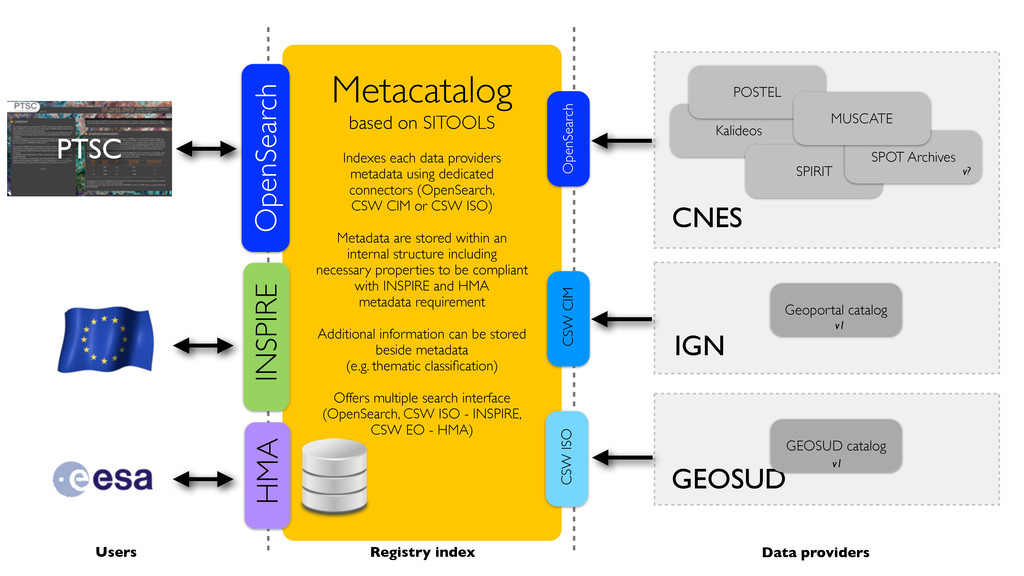
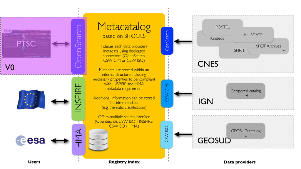
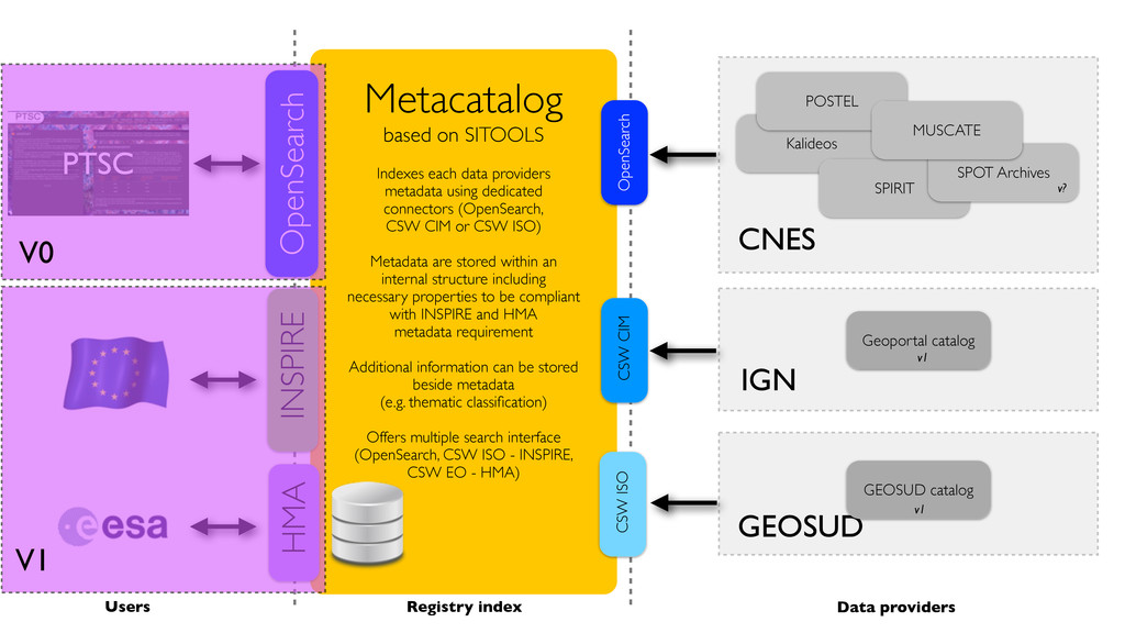
Presentation of the architecture of the french Land Imagery portal data access

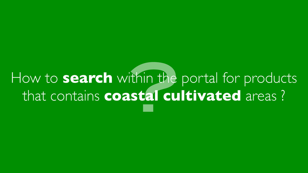
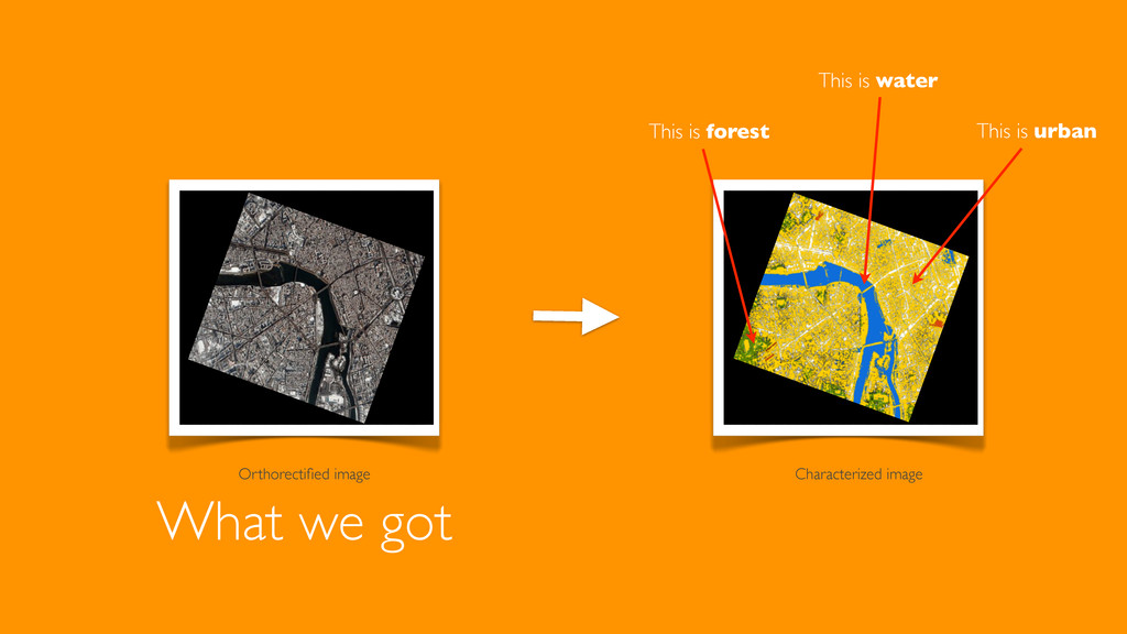
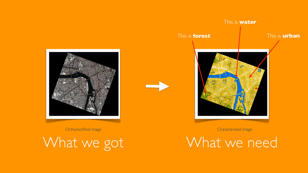
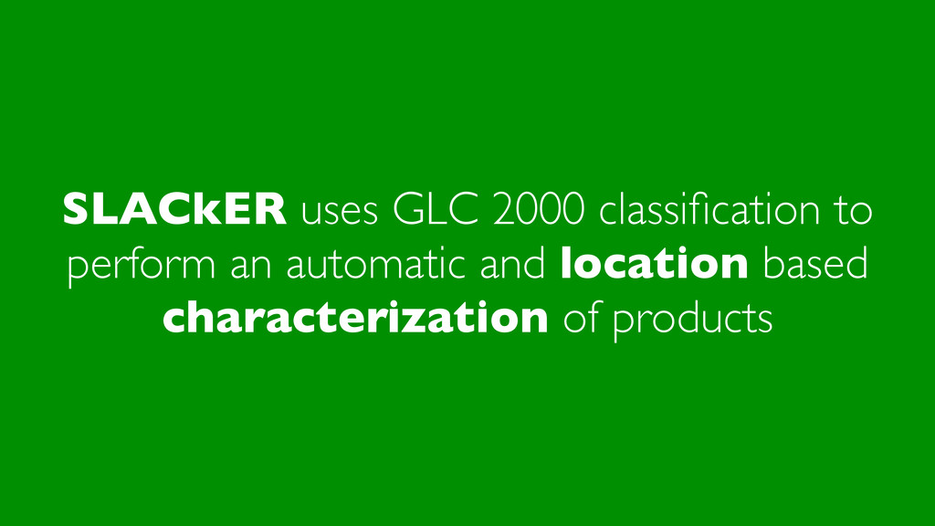
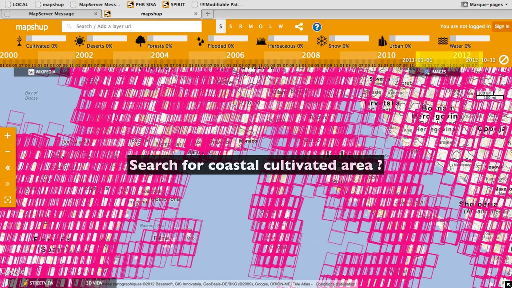
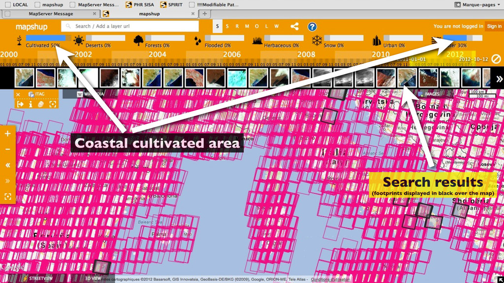
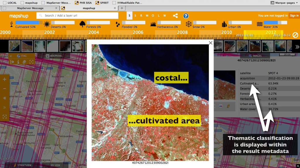
Keywords: CNES, PTSC, Web portal, catalog, OpenSearch, semantic search, Earth Observation, EO, satellite imagery, Land cover, mapshup

Jérôme Gasperi

October 12, 2012
Tweet

More Decks by Jérôme Gasperi

Other Decks in Technology

Transcript

  1. Data access and Data extraction Services within the Land Imagery

    portal Jerome Gasperi @ CNES | HAWG - Models for scientific exploitation of EO Data Frascati, Italy - October 12th, 2012
  2. The PTSC* is the future French "Thematic Center for Land

    Imagery" * temporary name, subject to change when operational
  3. v0 (end of 2012) Official launch of the portal v1

    (2013) additionnal datasets from CNES and partners, SSO integration, etc.
  4. Metacatalog based on SITOOLS Indexes each data providers metadata using

    dedicated connectors (OpenSearch, CSW CIM or CSW ISO) Metadata are stored within an internal structure including necessary properties to be compliant with INSPIRE and HMA metadata requirement Additional information can be stored beside metadata (e.g. thematic classification) Offers multiple search interface (OpenSearch, CSW ISO - INSPIRE, CSW EO - HMA) Kalideos SPIRIT OpenSearch SPOT Archives POSTEL MUSCATE CNES CSW CIM IGN Geoportal catalog CSW ISO GEOSUD GEOSUD catalog Data providers Registry index OpenSearch Users PTSC v? v1 v1
  5. Metacatalog based on SITOOLS Indexes each data providers metadata using

    dedicated connectors (OpenSearch, CSW CIM or CSW ISO) Metadata are stored within an internal structure including necessary properties to be compliant with INSPIRE and HMA metadata requirement Additional information can be stored beside metadata (e.g. thematic classification) Offers multiple search interface (OpenSearch, CSW ISO - INSPIRE, CSW EO - HMA) Kalideos SPIRIT OpenSearch SPOT Archives POSTEL MUSCATE CNES CSW CIM IGN Geoportal catalog CSW ISO GEOSUD GEOSUD catalog Data providers Registry index OpenSearch Users PTSC INSPIRE HMA v? v1 v1
  6. Metacatalog based on SITOOLS Indexes each data providers metadata using

    dedicated connectors (OpenSearch, CSW CIM or CSW ISO) Metadata are stored within an internal structure including necessary properties to be compliant with INSPIRE and HMA metadata requirement Additional information can be stored beside metadata (e.g. thematic classification) Offers multiple search interface (OpenSearch, CSW ISO - INSPIRE, CSW EO - HMA) Kalideos SPIRIT OpenSearch SPOT Archives POSTEL MUSCATE CNES CSW CIM IGN Geoportal catalog CSW ISO GEOSUD GEOSUD catalog Data providers Registry index OpenSearch Users PTSC INSPIRE HMA V0 v? v1 v1
  7. Metacatalog based on SITOOLS Indexes each data providers metadata using

    dedicated connectors (OpenSearch, CSW CIM or CSW ISO) Metadata are stored within an internal structure including necessary properties to be compliant with INSPIRE and HMA metadata requirement Additional information can be stored beside metadata (e.g. thematic classification) Offers multiple search interface (OpenSearch, CSW ISO - INSPIRE, CSW EO - HMA) Kalideos SPIRIT OpenSearch SPOT Archives POSTEL MUSCATE CNES CSW CIM IGN Geoportal catalog CSW ISO GEOSUD GEOSUD catalog Data providers Registry index OpenSearch Users PTSC INSPIRE HMA V0 V1 v? v1 v1
  8. Two cases : url content mimeType is "text/html" No direct

    download. The url is opened in another browser tab. User follows the instructions on the corresponding web page to download the product (this is typically the case for a product that required to explicitely sign an NDA before downloading it) otherwise product can be downloaded directly No common downloading format has been decided yet. The products are downloaded as is.
  9. Important note - the following slides present a proposal that

    will be discussed by the PTSC partners to be integrated (or not) within the Land Imagery portal.
  10. ? How to search within the portal for products that

    contains coastal cultivated areas ?
  11. SLACkER uses GLC 2000 classification to perform an automatic and

    location based characterization of products
  12. World land cover TIFF file ~ 650 Mo 1 km

    resolution 1 color = 1 thematic class 22 classes Global Land Cover 2000
  13. Metacatalog OpenSearch PTSC 1. Get footprint bounding box 2. Get

    GLC2000 area 3. Process characterization 4. Store results SLACkER 0. Get metadata Identifier Description Copyright Acquisition date Acquisition angles Thumbnail ... + Footprint
  14. Tag table images within database glc2000 >> Add classification columns

    >> Processing 10 Crop GLC2000 raster : 24137 6169 156 119 Polygonize extracted raster Process footprint against Global Land Cover Store classification => 40.89% of Deserts (10 + 14 + 19) => 31.89% of Herbaceous (9 + 11 + 12 + 13) => 14.71% of Water (20) => 9.27% of Cultivated (15 + 16 + 17 + 18) => 3.2% of Forests (1 + 2 + 3 + 4 + 5 + 6) ( 28.65 % of 14 : Sparse Herbaceous or sparse Shrub Cover ) ( 6.1 % of 18 : Mosaic: Cropland / Shrub or Grass Cover ) ( 12.24 % of 19 : Bare Areas ) ( 31.88 % of 12 : Shrub Cover, closed-open, deciduous ) ( 2.5 % of 3 : Tree Cover, broadleaved, deciduous, open ) ( 14.71 % of 20 : Water Bodies (natural & artificial) ) ( 0.13 % of 15 : Regularly flooded Shrub and/or Herbaceous Cover ) ( 2.81 % of 16 : Cultivated and managed areas ) ( 0.69 % of 4 : Tree Cover, needle-leaved, evergreen ) ( 0.21 % of 17 : Mosaic: Cropland / Tree Cover / Other natural vegetation ) Processing result example INPUT : metadata OUTPUT : additional thematics info stored beside the metadata within the Metacatalog