Upgrade to Pro — share decks privately, control downloads, hide ads and more …

공간정보와 링크드 데이터

LODAC
February 18, 2016

공간정보와 링크드 데이터

LODAC

February 18, 2016
Tweet

More Decks by LODAC

Other Decks in Technology

Transcript

  1. 2 공간정보 서비스와 공공데이터 개방  가장 친숙한 공간정보 서비스?

    – 서울버스 앱 (2009)  이를 계기로 공공데이터의 개방 및 공유 시작
  2. 4 공공데이터포털 – DATA.GO.KR  개방 현황 – 2016년 2월

    14일 현재  개방기관: 834 파일데이터: 14,556 오픈 API: 1,939
  3. 5 공공데이터포털 – DATA.GO.KR  이달의 추천 데이터 – 1월

     제공기관, 데이터 내용, 건수, 제공방식, 활용예시 등
  4. 7 왜 공간정보 데이터를 공유해야 할까?  공간정보의 중요성 

    도로, 철도, 항만과 같은 사회간접자본으로 생산, 유통, 소비 등 경제활동의 기반  투자규모가 크고, 투입된 자본의 회수에 오랜 기일이 소요되며, 효과가 사회전반에 미침  따라서 공공기관이나 정보의 주도에 의해 투자  새로운 서비스 기회를 제공  공간정보와 관련 서비스의 결합
  5. 9 채용정보 - 계속  채용정보 확인  채용정보를 클릭해서

    상세 내용을 확인  연결된 정보들의 내용 확인이 가능
  6. 11 어떻게 구현했을까? – 원래 계획 행정구역: 대구 달서구 근무지역:

    대구 달서구 산업단지: 역세권: 자격면허: 정보처리기사 자격명: 정보처리기사 지역: 대구 달서구 도서명: 정보처리기사 국립중앙도서관 국토부 (공간정보포털) 한국고용정보원 - 워크넷 한국산업인력공단 - 큐넷 전월세지원센터
  7. 13 데이터는 어떻게 가져올 수 있을까?  파일데이터  받아와서

    어떻게 이해하고 처리해야 할까?  원본 데이터에 변경이 생긴다면?  오픈 API  제공하는 측에 의존적  여러 군데에서 가져온 다른 데이터와의 연결은?  LOD (Linked Open Data)???
  8. 14 LOD의 기본 개념  Linked Data?  Basic Building

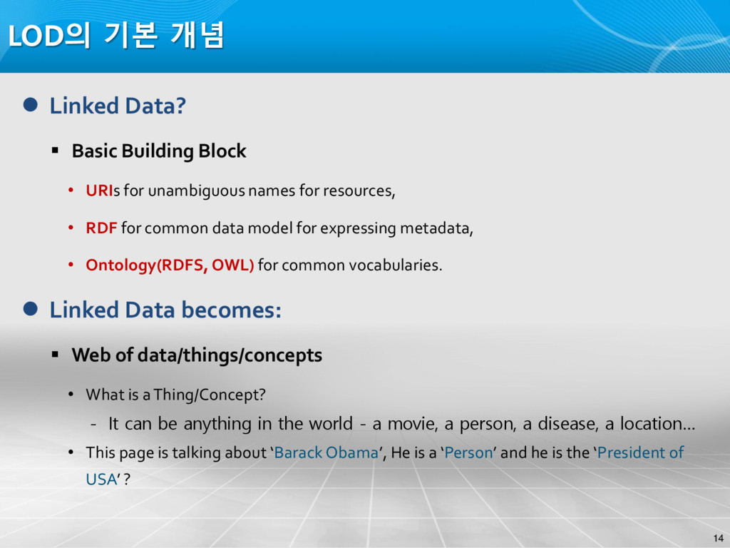
    Block • URIs for unambiguous names for resources, • RDF for common data model for expressing metadata, • Ontology(RDFS, OWL) for common vocabularies.  Linked Data becomes:  Web of data/things/concepts • What is a Thing/Concept? - It can be anything in the world - a movie, a person, a disease, a location… • This page is talking about ‘Barack Obama’, He is a ‘Person’ and he is the ‘President of USA’ ?
  9. 15 LOD의 기본 개념  Knowledge is represented in RDF

    as a set of Triples.  What is a Triple?  Triple in RDF is analogous a sentence in natural language.  The form <subject, predicate, object> • Every NL sentence contains 3 parts: subject, predicate & object.  Example: • NL Sentence: Obama is the president of USA • RDF Triple: <URI1#Obama> <URI2#presidentOf> <URI3#USA> Adapted from narnirajesh.blogspot.com subject predicate object
  10. 16 LOD의 기본 개념  RDF as a Graph 

    An RDF document is best visualized as a graph.  Graph notations: • Resources (URI) • Literals (simple values) • Properties  Set of triples represented as a graph Adapted from narnirajesh.blogspot.com URI1#Obama URI2#USA 45 URI4#Person
  11. 17 LOD의 기본 개념  RDF – Serialization Formats 

    An RDF graph is a logical model, we need to serialize in some format.  What serialization Formats does RDF support? • RDF/XML (XML based syntax, popular), NTriple (each triple is represented in one line), Turtle etc.  Example:  RDF/XML format: <rdf:Description rdf:about=“URI1#Obama"> <rdf:type rdf:resource=“URI4#Person" /> <URI2#isPresidentOf rdf:resource=“URI3#USA" /> </rdf:Description>  NTriple format: <URI1#Obama> <URI2#presidentOf> <URI3#USA> <URI1#Obama> < http://www.w3.org/1999/02/22-rdf-syntax-ns#type> < URI4#Person> Adapted from narnirajesh.blogspot.com
  12. 19 LOD의 기본 개념  Linked Open Data  Building

    a “Web of Data” to connect Distributed Data across the Web  The Linking Open Data (LOD) project:  http://linkeddata.org/  Translating existing datasets into RDF and linking them together. • For example, DBpedia (Wikipedia) and GeoNames, Freebase, BBC programmes, etc.  Government data also available as Linked Data • DATA.gov • DATA.gov.uk
  13. 24 공간정보 공유와 LOD 역할 • 다양한 공간정보의 통합 연계

    체계 • Connected (External/Internal) • 편리한 맞춤형 공간정보 검색 • Easy Find (Semantics) • 상호운영성과 지속가능한 서비스 체계 • Interoperable/Harvestable
  14. 25 공간정보 공유와 LOD 역할  공간정보 통합 연계 체계

     GeoNames.org Dataset Category In- degree dbpedia.org cross-domain 207 geonames.org geographic 141 w3.org cross-domain 117 quitter.se social web 64 status.net social web 63 postblue.info social web 56 skilledtests.com social web 55 reference.data.gov.uk government 45 data.semanticweb.org publications 44 fragdev.com social web 41 lexvo.org cross-domain 37 Datasets with the ten highest indegrees
  15. 26 공간정보 공유와 LOD 역할  공간정보 통합 연계 체계

     LinkedGeoData.org • An effort to add a spatial dimension to the Web of Data
  16. 27 공간정보 공유와 LOD 역할  맞춤형 공간정보 검색 사례

     Semantic Web for Geospatial E-Government Portals • The 8th annual international conference on Digital government research (2007)
  17. 28 Semantic Web 기반 검색이란? • 인터넷 검색의 만능도구 –

    키워드 검색 • 네이버, 구글…  네이버에게 물어봐!
  18. 31 온톨로지  특정 도메인에서의 개념과 개념 사이의 관계, 개념의

    인스턴스 집합으로 표현 문_1 파랑 소나타_1 빨강 색깔 달려있다 색깔 색상 문 승용차 instanceOf (type) 개념 인스턴스 관계 혹은 속성
  19. 32 공간정보 공유와 LOD 역할  맞춤형 공간정보 검색 사례

     Creating and Using Geospatial Ontology Time Series in a Semantic Cultural Heritage Portal (2008)
  20. 34 공간정보 공유와 LOD 역할  공간정보 상호운영성 사례 

    A Framework for Semantic Interoperability for Distributed Geospatial Repositories (2008)
  21. 35