Upgrade to Pro — share decks privately, control downloads, hide ads and more …

State of GeoNode 3.2.0

State of GeoNode 3.2.0

Presentation from GeoSolutions on the recent GeoNode 3.2 release.

Simone Giannecchini
PRO

April 29, 2021
Tweet

More Decks by Simone Giannecchini

Other Decks in Programming

Transcript

  1. GeoNode 3.2 Webinar
    April 28, 2021
    Luis E. Bermudez, Ph.D
    GeoSolutions USA - CEO

    View Slide

  2. Agenda
    - 11:00 – 11:10 Introduction
    - 11:10 - 12:00 Presentation
    - 12:00 – 12:30 Questions
    Post questions any time using Q&A

    View Slide

  3. Presenters

    View Slide

  4. GeoSolutions
    GeoSolutions is one of the world’s
    leaders in supporting open-source
    geospatial software.
    ~ 30 Staff
    > 200 Clients
    - Actively participant in the OGC

    View Slide

  5. UN FAO (CIOK, FIGIS,
    NRL, FORESTRY,
    ESTG), UN WFP,
    World Bank, DLR,
    EUMETSAT, JRC,
    ARPAT, NATO CMRE,
    UNESCO, IGAD,
    UNEP, ...
    BAYER, BASF,
    DigitalGlobe, MDA,
    TOPCON, SwissRE, e-
    GEOS, Halliburton,
    ..
    More than 200 clients since 2006

    View Slide

  6. GeoSolutions Support
    • Advice regarding a geospatial challenge
    • Architect, help configure and deploy clusters of GeoNodes
    in the cloud
    • Automate deployments from different environments
    • Performance monitoring
    • Develop custom application (server or client slide)
    • Optimize ingesting and publishing geospatial data
    • Training
    • Other technical support

    View Slide

  7. GeoSolutions Offer
    •Enterprise Support
    •Subscription Services
    •Training

    View Slide

  8. GeoSolutions Contact Information
    Luis E. Bermudez, Ph.D.
    CEO
    GeoSolutions USA
    https://www.geosolutionsgroup.com/contacts/
    +1 (301) 337-7055
    [email protected]
    https://www.linkedin.com/in/bermudez
    https://www.geosolutionsgroup.com
    https://twitter.com/geosolutions_it

    View Slide

  9. View Slide

  10. State of GeoNode
    3.2.0
    Online Webinar
    2021-04-28

    View Slide

  11. This presentation is brought to you by
    The GeoNode PSC

    View Slide

  12. GeoNode at a Glance
    A web framework based on
    Python and Django to allow
    people to upload, describe, share
    and use their geospatial data.
    We usually define GeoNode as a
    geospatial-CMS.
    Core Components
    • Django
    • PotsgreSQL-PostGIS
    • GeoServer
    • GeoWebCache
    • pycsw
    • MapStore

    View Slide

  13. Capabilities
    o Upload geospatial datasets (by default shapefiles and GeoTIFFs)
    o User with appropriate permissions can edit layer metadata, which
    are exposed by OGC CSW and REST, to provide search/discovery
    capability
    o Create thematic maps accessible to general public
    o Users with appropriate permissions can edit layer styles and
    features (for vector layers)
    o Granular permission systems: viewing, downloading, metadata
    editing, styles and feature editing for a layer can be restricted to
    users or groups
    o GeoNode exposes a number of standards for each layer: OGC
    (WMS, WMS-C, WFS, WFS-T, WCS, CSW) and mass market
    search standards (OAI-PMH, SRU, OpenSearch)

    View Slide

  14. Release History
    o April 2021, GeoNode 3.2.0 (Django 2.2.16, GeoServer 
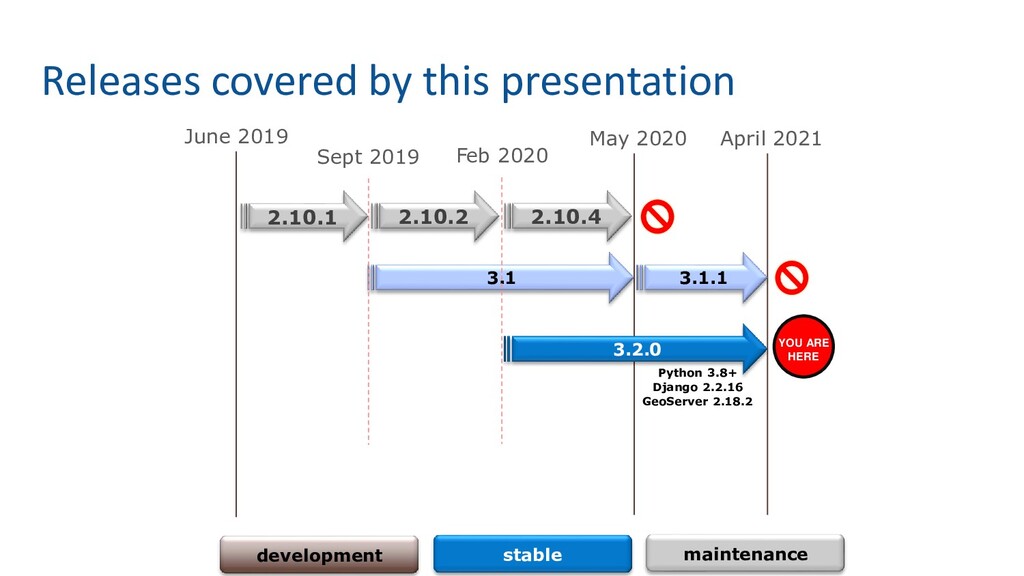
2.18.2) / GeoNode 3.1.1 (last 3.1 release)
    o May 2020, GeoNode 3.0 (Django 2.2.13, GeoServer 2.16.2) / GeoNode 2.10.4 (last 2.10 release)
    o February 2020, GeoNode 2.10.2 (Django 1.11.29, GeoServer 2.15.4, pycsw 2.4.2)
    o June 2019, GeoNode 2.10 (Django 1.11.20, GeoServer 2.14, pycsw 2.2.0)
    o April 2018, GeoNode 2.8 (Django 1.8.19, GeoServer 2.12.2, pycsw 2.0.2, group moderation
    and resources publication workflow, SLD upload, metadata wizard)
    o May 2017, GeoNode 2.6 (Django 1.8.7, GeoServer 2.9, pycsw 2.0.2, React client, QGIS
    server backend, ansible and docker setup, Ubuntu 16.04 support)
    o November 2015, GeoNode 2.4 (Django 1.6.11, GeoServer 2.7, pycsw 1.10.5, django-
    guardian, groups, remote services, responsive template, Ubuntu 14.04 support)
    o April 2014, GeoNode 2.0 (Django 1.5.5, GeoServer 2.5, pycsw 1.8.6, django-polymorphic,
    bootstrap, Ubuntu 12.04 support)
    o October 2012, GeoNode 1.2 (Django 1.4, GeoServer 2.3, South migrations, django-taggit,
    social features, comments and ratings, find/add layers widget)
    o May 2012, GeoNode 1.1.1 (Ubuntu 10.04 and 11.04 installer)
    o December 2010, GeoNode 1.0, with major contributions from OpenGeo, the World Bank,
    GFDRR, UNISDR, and GEM
    o August 2010, GeoNode 1.0-beta

    View Slide

  15. GeoNode
    2020/21
    What’s in a year?

    View Slide

  16. June 2019
    Releases covered by this presentation
    2.10.1
    3.1
    development stable maintenance
    Python 3.8+
    Django 2.2.16
    GeoServer 2.18.2
    YOU ARE
    HERE
    Sept 2019
    May 2020
    Feb 2020
    2.10.2 2.10.4
    3.2.0
    April 2021
    3.1.1

    View Slide

  17. Are you using a older version? Upgrade!
    o User/Developer lists and Gitter typically covers only supported versions
    o Today it means only 3.2.x
    o Security fixes and installation support on new OSs being added to supported
    versions only!
    o Moving data from old versions will be much harder if not impossible
    o Web interfaces and GIS clients will be much different. No one will be able to
    backport fixes or improvements to the old ones.
    o Please upgrade your GeoNode installations!!!

    View Slide

  18. What’s new?

    View Slide

  19. Upgrade? What’s in it for me?
    o Let’s check what’s new in 3.2.0 upcoming release
    o Check the bottom of each slide to see who sponsored a certain feature,
    who implemented it, and what version contains it
    Sponsor Author Version

    View Slide

  20. Upgrade to GeoServer 2.18.2
    Community
    GeoSolutions
    GeoSolutions 3.2.0
    Improvements and Fixes
    • Improved GWC seeding scalability (also check GWC 1.18.2 release notes).
    • Fixed back-links generation during WPS asynchronous requests, when a proxy base URL is used.
    • Fixed a GeoFence server packaging issue.
    • A number of dependent libraries have been upgraded, including the PostgreSQL and MySQL JDBC drivers, HTTP
    components, Guava.
    • The new support for COGs based on ImageIO Ext landed in a community module, adding it adds support for COG in
    both the GeoTIFF reader and image mosaic. Support for harvesting COG granules is also added in the REST API.
    • A deadlock in JDBCConfig has been resolved, along with issues related to high load when GeoServer has just started up.
    • The WPS download “map” and “animation” processes sport improved legend support.
    For more information check the 2.18.2 release notes.
    Community Updates
    ✓ Backup & Restore
    ✓ OAuth2
    ✓ GeoFence

    View Slide

  21. Upgrade to MapStore Client 2.1.3
    Community
    GeoSolutions
    GeoSolutions 3.2.0
    Improvements and Fixes
    • Save Search Services to the Map
    • Save Map Preferences into the adapter model
    • Advanced Style Editor with graphical UI
    • Improved Map Save Widget, specific for GeoNode
    • New MapStore client configuration subsystem
    • Group Layer as named groups
    For more information check the 2.1.3 release notes.
    For technical details check:
    https://github.com/GeoNode/geonode-mapstore-client#readme

    View Slide

  22. MapStore Advanced Styler
    AlmavivA
    GeoSolutions
    GeoSolutions 3.2.0
    o Old Styler was somewhat “poor”
    ✓ Widget based styler
    ✓ Vector data classifications
    ✓ Raster Data Classifications
    ✓ Well Known Markers
    ✓ Advanced Styling Options

    View Slide

  23. MapStore WPS Based Async Export
    AlmavivA
    GeoSolutions
    GeoSolutions 3.2.0
    o Relies on WMS Download Process to export data asynchronously
    ✓ Different File Formats
    ✓ Native or WGS-84 projections
    ✓ Crop dataset option
    ✓ Download filtered dataset
    ✓ Export data results

    View Slide

  24. MapStore Compare Tools
    AlmavivA
    GeoSolutions
    GeoSolutions 3.2.0
    o Several GUI based comparison tools: slides, spy-glass, …

    View Slide

  25. MapStore Groups & Save Services
    AlmavivA
    GeoSolutions
    GeoSolutions 3.2.0

    View Slide

  26. Breaking Changes
    o Bump to postgresql-13; do not upgrade the docker image or be prepared to
    do a dump/restore of the DB
    o Based on MapStore client 2.1.3; MapStore client is no more compatible with
    3.0.x and 3.1.x train
    o ResourceBase Model BBOX now is a geometry; that is no more compatible
    with the 3.1.x one
    o Revised Async Model; tasks and queues have been updated and refreshed.
    Introduced a non-blocking lock mechanism based on MEMCACHED.
    o GNIP-81 - GeoNode Core Cleanup (ongoing…):

    Removed GeoNetwork support

    Removed QGIS-Server support

    Removed SPC GeoNode support

    Advanced Resources Publishing Logic has been revised
    Community
    GeoSolutions
    Catalyst
    CSGIS
    3.2.0

    View Slide

  27. Breaking Changes: BBOX Geometries
    o ResourceBase Model BBOX now is now a Geo-Django geometry field
    o The migrations should fix automatically the model from old releases
    o The management command “set_all_layers_metadata -d” refreshes and
    synchronizes the BBOXes with the GeoServer layers ones
    Community
    Catalyst
    GeoSolutions
    Catalyst
    CSGIS
    3.2.0

    View Slide

  28. Breaking Changes: Revised Async Model
    o Enabling Fully Asynchronous Tasks:
    o https://docs.geonode.org/en/master/install/advanced/core/index.html#enabling-fully-asynchronous-tasks
    o Enabled and configured by default on the Docker images
    o Upgrade from old Dockerized instances will require to drop the rabbitmq image
    in order to let GeoNode recreate the queues and topics correctly
    Community GeoSolutions 3.2.0

    View Slide

  29. GNIP-76: Add RTL Support
    CSGIS CSGIS 3.2.0
    ✓ This GNIP suggest enabling right-to-left support for named languages
    https://github.com/GeoNode/geonode/issues/6156

    View Slide

  30. GNIP-77: GetFeatureInfo Templating For GeoNode
    AlmavivA GeoSolutions 3.2.0
    ✓ This proposal aims to improve the way GeoNode injects a “GetFeatureInfo” Template into the maps created with
    MapStore2
    https://github.com/GeoNode/geonode/issues/6182

    View Slide

  31. GNIP-78: GeoNode generic "Apps" model
    to include pluggable entities into the
    framework
    AlmavivA / GeoSolutions GeoSolutions 3.2.0
    https://github.com/GeoNode/geonode/issues/6684
    o GeoSpatial Storytelling in GeoNode
    ✓ MapStore Plugin
    ✓ Reuse GeoNode Layers and Resources to build Story
    ✓ Images, Video, Maps and so on
    ✓ Integrated visual editor
    ✓ Documents now support more media-types

    View Slide

  32. GNIP-79: GeoNode REST APIs (v2)
    AlmavivA GeoSolutions 3.2.0
    ✓ Create a real REST API for GeoNode resources, which is:
    ✓ Pluggable: new external dependencies and modules should be easily allowed to add their own API endpoints
    without modifying the GeoNode code base.
    ✓ Modular: each app has their own API module if needed. No more monolithic modules with a ton of classes
    ✓ REST compliant: the new API must adhere to the REST paradigm and protocol
    ✓ Lives together with the standard Tastypie based GeoNode APIs
    https://github.com/GeoNode/geonode/issues/6685
    Allows for search, filtering, ordering, field embedding:
    https://github.com/AltSchool/dynamic-rest#demo
    e.g.:
    ❖ https://master.demo.geonode.org/api/v2/geostories/20?include[]=data
    ❖ https://master.demo.geonode.org/api/v2/resources?filter{resource_type}=layer

    View Slide

  33. GNIP-82: Thesauri improvements
    AlmavivA GeoSolutions 3.2.0
    ✓ Thesauri implementation needs some revision, update and
    improvements.:
    ✓ Handle multiple thesauri
    ✓ Improve i18n in thesauri titles
    ✓ Improve cardinality handling
    https://github.com/GeoNode/geonode/issues/6925
    Linked issues:
    Upload RDF thesaurus via web: https://github.com/GeoNode/geonode/issues/7150
    Docs: https://docs.geonode.org/en/master/admin/thesaurus/#loading-a-thesaurus

    View Slide

  34. GNIP-83: ResourceBase for metadata-only resources
    AlmavivA GeoSolutions 3.2.0
    ✓ Flag ResourceBase instances in order not to be displayed in the GUI, but only available through CSW.
    ✓ With this kind of "hidden" ResourceBase, our underlying pyCSW can be decoupled from the data handled in
    GeoNode/GeoServer, and regain a bit of the functionalities lost when using the internal pyCSW (the only one
    currently maintained) with external catalogues.
    ✓ A good use case is the publishing of service metadata documents that details the WMS, WFS and WCS services
    offered by our GeoNode/GeoServer instance.
    https://github.com/GeoNode/geonode/issues/7057
    A service metadata is an ISO19115 metadata which describes the service in
    its entirety.
    The responsible parties are the ones running the service, which are not
    described in the data.
    Service metadata also describes the various operation available in the
    service, which operations are supported, which are the standards it
    conforms to, which are other qualitative and quantitative constraints it
    follows.
    INSPIRE requires that a catalogue should provide service metadata for an
    organization.
    If GeoNode can not provide them, then GeoNode can only be used as a slave
    catalogue by some other high level catalogue that can include such extra
    metadata.
    With this GNIP we can remove the use of other catalogues in the architecture.

    View Slide

  35. GNIP-84: Upload Page Enhancements
    https://github.com/GeoNode/geonode/issues/7154
    o Improved the upload of resources both manual as well as programmatic.
    o A first page of enhancements has landed as per GNIP-84,
    which provides better control over upload
    sessions, first of all the ability to terminate
    sessions after we have left the upload page.
    GeoSolutions GeoSolutions 3.2.0
    ✓ Improved Async Upload of Layers
    ✓ GeoServer Importer Uploads are now stateful and can be
    resumed or cancelled

    View Slide

  36. GNIP-85: Map legends
    ADBPO GeoSolutions 3.2.0
    https://github.com/GeoNode/geonode/issues/7254

    View Slide

  37. GNIP-86: Metadata parsing and storing
    AlmavivA GeoSolutions 3.2.0
    ✓ Metadata parsing is not easily customizable.
    ✓ The proposed changes allows to
    ✓ Define one or more custom parsers, in order to be able to handle metadata documents following specific
    profiles not handled by OWSLib.
    ✓ Add an hook to handle custom DB object on layer creation.
    ✓ Other tasks included:
    ✓ Fix keyword parsing.
    https://github.com/GeoNode/geonode/issues/7263
    Linked issues:
    • #7279: Keyword parsing improvements
    • #7288: Layer saving clean up
    Docs: https://docs.geonode.org/en/master/basic/settings/index.html#metadata-parsers

    View Slide

  38. GNIP 87: Reduce information returned to users to only what is
    strictly required and accessible
    UNESCO GeoSolutions 3.2.0
    ✓ Fixes a security leak:
    ✓ GeoNode's /owners API endpoint returns the full list of users, including their personal information (!!!!). Also it
    returns users with no resources.
    https://github.com/GeoNode/geonode/issues/7282

    View Slide

  39. Append data to an existing layer feature
    AlmavivA GeoSolutions 3.2.0

    View Slide

  40. Rich-text editors on Metadata Wizard
    AlmavivA GeoSolutions 3.2.0

    View Slide

  41. Improved Thumbnails
    AlmavivA GeoSolutions 3.2.0
    ✓ Thumbs creation logic which now relies on WMS GetMap instead of outdated GeoServer Print Plugin
    ✓ Better quality and ratio
    ✓ Works on any WMS-based service
    ✓ Works on most of the Remote Services also
    ✓ Does not relies on GeoServer plugins and therefore
    does not consume memory and resources on server side

    View Slide

  42. Improved B/R Machinery
    ADBPO GeoSolutions 3.2.0
    ✓ Refactored B/R code
    ✓ Now, by default, it performs an hard restore, by removing also the DATA tables on the target

    View Slide

  43. Advanced Upload Workflow Improvements
    ADBPO GeoSolutions 3.2.0
    ✓ When the Advanced Upload Workflow is enabled:
    ✓ Non admin user cannot change permission
    ✓ Disable edit permissions globally when read-only mode is active
    ✓ Unapproved Resources:
    ✓ The owner won't be able to change to neither "approved" nor "published" state (unless he is a
    superuser)
    ✓ If the Resource belongs to a Group somehow, the Managers will be able to change the state to
    "approved" but NOT to "published". Only a superuser can publish a resource.
    ✓ By default the uploaded resources will be "unpublished“:
    ✓ "unpublished" won't be visible to Anonymous users
    ✓ "unpublished" will be visible to registered users IF they have view permissions
    ✓ "unpublished" will be always visible to the owner and Group Managers
    ✓ If the owner assigns "unpublished" resources to a Group, both from Metadata and Permissions, in any
    case the Group "Managers" will be able to edit the Resource.
    ✓ The "unapproved" and "unpublished" Resources will be accessible ONLY by owners, superusers and members
    of the belonging groups.

    View Slide

  44. New Contrib Apps: GeoNode extension Keycloak-Role Django
    Application
    Community Community 3.2.0
    ✓ The goal of this application is to synchronize Keycloak roles with GeoNode group profiles.
    ✓ The application creates a connection with Keycloak. Using client credentials the roles are retrieved from Keycloak.
    Each role is then assigned a group.
    ✓ The synchronize button can be found in Django Administration page, Home -> Keycloak -> Keycloak roles and right
    next to add Keycloak role button.
    https://github.com/GeoNode/geonode-contribs/tree/master/django-geonode-keycloak

    View Slide

  45. Translations
    Community THUNEN 3.2.0
    o Updated translations for all the languages and revised the major ones
    o Other related issues with frontend behavior
    ✓ ISO category translation not shown #6984
    ✓ makemessages command will set fixture translations to inactive #7015
    ✓ multi word iso category strings will not get translated #7126
    ✓ html body class translate #7354

    View Slide

  46. Other Fixes and Improvements
    Community Community 3.2.0
    ✓ Improving GeoNode Theme Library: introducing Jumbotron Slides
    ✓ Implementation of an action to assign bulk permissions on layers to users selected from People and/or Group Django
    admin forms enhancement #6582
    ✓ File system operations do not adhere to Django file storage API enhancement in progress #6414
    ✓ Nav Toolbar gets distorted when multiple navbar items are added by the admin enhancement frontend major #6412
    ✓ Improve GeoNode OpenID SP Protocol in order to be able to provide access to external clients enhancement security
    #6273
    ✓ Limit "maps using this layer" to maps the user has permission to see enhancement security #6261
    ✓ Prevent integrity errors on singleton model save enhancement #6223
    ✓ …

    View Slide

  47. What’s
    cooking?

    View Slide

  48. Next 3.2.x minors
    GeoSolutions 3.2.x
    ✓ Upgrade Geoserver to 2.18.3
    ✓ Review and improve Docker configurations
    ✓ Improve the permissions system, and their integration with the client
    ✓ Introduce GUI based execution of management commands
    ✓ Start the refactoring of the monitoring service
    ✓ Integrate MapStore Dashboards

    View Slide

  49. Dashboard GeoApp - data dashboards in GeoNode
    GeoSolutions 3.2.x
    ✓ Dashboard is a space where the user can add many Widgets, such as charts, maps, tables, texts and counters, and
    can create connections between them in order to:
    • Provide an overview to better visualize a specific data context
    • Interact spatially and analytically with the data by creating connections between widgets
    • Perform analysis on involved data/layers
    ✓ Add Maps and Layers from the GeoNode catalogue
    ✓ Integrated visual editor
    https://geosolutionsgroup.com/blog/mapstore-release-dashboards/
    https://mapstore.readthedocs.io/en/latest/user-guide/exploring-dashboards/

    View Slide

  50. Master branch
    GeoSolutions 3.2.x
    ✓ New SPA client based on React and MapStore
    • New home page and user workspace
    • Refactoring of resource viewers and editors
    ✓ Introduction of a Resource Service which will provide the API to manage the full lifecycle of a resource
    ✓ Introduction of a Storage Service to implement proper management of the data storage for the resources
    ✓ Introduction of a Harvester Service which will implement a pluggable and extendable system for remote resources
    and data harvesting
    ✓ General improvements to the resource management and the core asynchronous systems to provide support for more
    advanced pipelines, which include:
    • imports from external storage services (AWS S3, Dropbox, etc.)
    • data pre-processing
    • interactive workflows
    • ….
    The Pacific Community

    View Slide

  51. Home Page and Workspace
    3.2.x
    ✓ React and MapStore based with improved layout
    ✓ Direct access to the full list of resources
    ✓ Quick live previews
    ✓ A home page for casual users, a workspace for
    contributors
    ✓ Visual and functional separation between catalogue
    and dataviz functionalities
    ✓ Improved organization of tools, layered on multiple
    visual levels, depending on the user profile (end user,
    data owner, administrator)
    GeoSolutions
    The Pacific Community

    View Slide

  52. Viewers and Editors
    3.2.x
    ✓ Simplified and clear UI/UX both for readers and
    editors
    ✓ Remove duplicated functionalities between backend
    pages and client
    ✓ Quick editing workflows
    ✓ Permissions management turned into sharing options
    GeoSolutions
    The Pacific Community

    View Slide

  53. Help us help
    you

    View Slide

  54. User Lists Participation
    o Answering users' questions relies on a low number of people
    o We lack “testers”; this kind of project would need also a lot of manual
    testing for all its functionalities on a regular basis
    o Developers are very few and Pull Requests often do not respect the
    contribution policies.
    In particular:
    ✓ There’s no GitHub issue describing the problem linked to the Pull Request
    ✓ GitHub issues are plain requests often without a good description of the use case and
    how to reproduce it
    ✓ Lack of test cases and documentation
    ✓ History of commits is usually messed up

    View Slide

  55. Steps to get in touch with developers
    1. If you need for clarification first of all try to describe the issue as well as
    possible through the official mailing lists; IMPORTANT: always specify
    ✓ Which versions of GeoNode and GeoServer you are using
    ✓ Which Operative System and hardware you are using
    ✓ How you installed the framework
    2. If you need to get in touch directly with developers, consider using the
    official “gitter” chat https://gitter.im/GeoNode/general
    2. If the issue has been confirmed and there’s no easy or immediate
    resolution, open a ticket on GitHub https://github.com/GeoNode/geonode/issues
    with steps on how to reproduce the problem and labels

    View Slide

  56. In case you stumble into a vulnerability:
    Responsible Disclosure
    o Keep exploit details out of issue report.
    o Mark the issue as a vulnerability.
    o Be prepared to work with Project Steering Committee (PSC) on a solution.
    o Keep in mind PSC members are volunteers and an extensive fix may require
    fundraising / resources.
    If you are not in position to communicate in public please consider commercial
    support, contacting a PSC member, or reaching us via the Open Source
    Geospatial Foundation at [email protected]

    View Slide

  57. Thanks

    View Slide