$30 off During Our Annual Pro Sale. View Details »

GIS and Location-based Augmented Reality

ATX GIS Day
November 13, 2019

GIS and Location-based Augmented Reality

Johnny Luce, Design Director and Co-Founder, Augzoo LLC

ATX GIS Day

November 13, 2019
Tweet

More Decks by ATX GIS Day

Other Decks in Technology

Transcript

  1. Geographical Information Systems
    &
    Location-based Augmented Reality
    A Review of Techniques, Challenges, and Possibilities
    Johnny Luce
    Design Director and co-founder, augzoo LLC.

    View Slide

  2. Johnny Luce
    Projects
    Employers
    Universities

    View Slide

  3. Today’s Agenda
    Define Augmented Reality (AR), with emphasis on location-based 
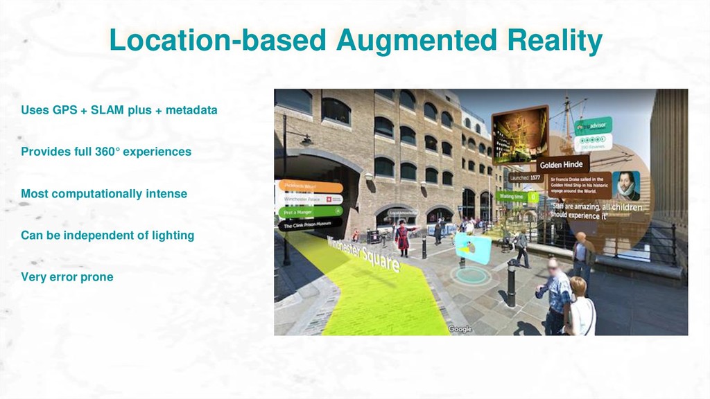
AR
    Describe various techniques used to achieve location-based AR
    Look at considerations for creating and storing content for location-based AR
    Explore user experience and possible use cases location-based AR

    View Slide

  4. A technology that superimposes a computer-generated image on a user's view of the real
    world, thus providing a composite view.
    Augmented Reality

    View Slide

  5. Augmented Reality
    Three forms of Augmented Reality
    Marker-based Markerless Location-based

    View Slide

  6. Marker required to activate
    Marker-based Augmented Reality
    Augmentation anchored to marker
    Markers: Image or QR code
    Easiest form of augmented reality
    Affected by lighting conditions
    Strict image requirements

    View Slide

  7. Markerless Augmented Reality
    Simultaneous Localization and Mapping
    (SLAM)
    Points used to calculate distance and angles
    Uses Computer Vision to align content to
    surfaces
    Computationally intense
    Affected by lighting conditions
    Error prone

    View Slide

  8. Markerless Augmented Reality
    Simultaneous Localization and Mapping
    (SLAM)
    Points used to calculate distance and angles
    Uses Computer Vision to align content to
    surfaces
    Computationally intense
    Affected by lighting conditions
    Error prone

    View Slide

  9. Location-based Augmented Reality
    Provides full 360° experiences
    Most computationally intense
    Uses GPS + SLAM plus + metadata
    Can be independent of lighting
    Very error prone

    View Slide

  10. The Challenge
    + =
    Accurately align virtual objects with real-world locations to produce convincing spatial
    interactions.

    View Slide

  11. Location / Position
    GPS 4 meter accuracy
    WiFi and RFID improves accuracy
    Latitude and Longitude
    Affected by buildings and weather

    View Slide

  12. Elevation and Altitude
    Altitude: height above ground
    Match eye level
    Elevation: ground height
    Match floor of building
    Hard to measure

    View Slide

  13. Heading
    Measured from magnetic North
    Many accuracy issues
    Forward facing direction
    Subject to Gimbal lock

    View Slide

  14. Pose
    Measured in Quaternions
    Difficult to measure accurately
    Roll, Pitch, and Yaw of the device
    Computationally intense
    Most important for believable 3D
    environments

    View Slide

  15. Motion Tracking
    Tracks unique points over time
    Points used to calculate angle and
    distance
    Computer Vision technique
    Computationally intense
    Affected by lighting conditions

    View Slide

  16. Occlusion Culling
    Adds depth and realism
    Very hard to calculate
    Disables rendering of objects when they
    are not currently seen by the camera

    View Slide

  17. Motion Tracking: Occlusion

    View Slide

  18. Collision Decection
    Adds depth and realism
    Can be very hard to calculate
    The computational problem of detecting
    the intersection of two or more objects

    View Slide

  19. Motion Tracking: Collision
    Collision

    View Slide

  20. The Challenge: Reprise
    + =
    Accurately align virtual objects with real-world locations to produce convincing spatial
    interactions.

    View Slide

  21. Sensor Fusion
    Goal Hardware Data
    Location / Position Global positioning 
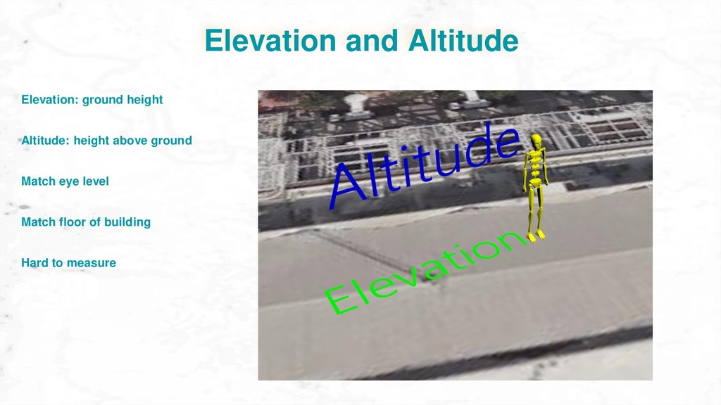
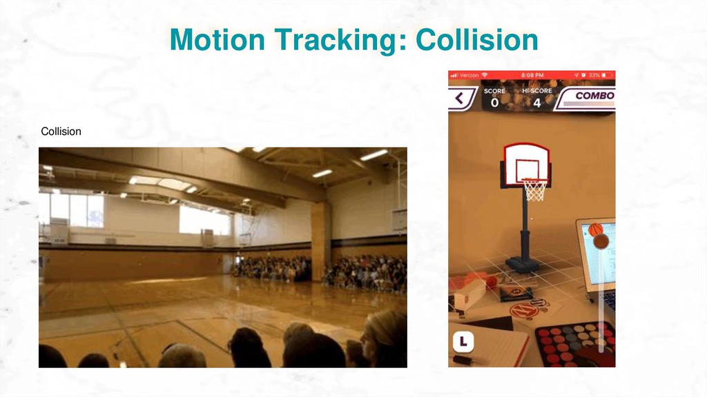
System,
    Wifi, RFID
    GIS and CAD files
    Elevation and Altitude Barometer, Wifi, RFID Markers, GIS and CAD files
    Pose / Heading Magnetometer, Camera,
    Infrared, Gyroscope,
    Accelerometer
    Markers, GIS and CAD files
    Occlusion and Collision Camera,Infrared GIS and CAD files
    The process of merging data from multiple sensors such that to reduce the amount of
    uncertainty.

    View Slide

  22. Primary GIS Data Types
    Elevation Vectors
    Data: GIS and CAD

    View Slide

  23. Data: GIS and CAD

    View Slide

  24. Data: GIS and CAD

    View Slide

  25. Data: GIS and CAD

    View Slide

  26. Data: GIS and CAD

    View Slide

  27. Cloud-based data storage

    View Slide

  28. Cloud-based data storage
    Table from a database. One object per row, with columns defining each object’s properties.

    View Slide

  29. Data: GIS and CAD
    Static Data
    Raster Vector Mesh
    Table from a database. One object per row, with columns defining each object’s properties.

    View Slide

  30. Data: Raster
    Stores elevation and or color values
    Each Pixel represents area, or resolution
    Images: GeoTIFF and MrSID, et al.
    Requires lots of disk space

    View Slide

  31. Data: Vector
    Points are defined by X,Y or Latitude, Longitude
    Points can be ordered as lines
    Stored in database or file: .KML. .SVG, .JSON
    Lines can be closed to form areas
    Good for features and locations
    Metadata to define features

    View Slide

  32. Data: Mesh
    Often has images for color: dtx, png, tiff...
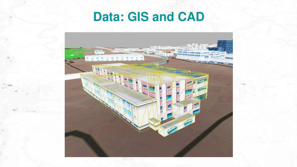
    Cartesian position, rotation, and scale
    Hand-crafted. Many formats: .obj, fbx, kmz...
    Provide high quality content
    Expensive and time consuming to produce
    Computationally intense

    View Slide

  33. User Experience
    Don’t do AR just because it is novel. Use appropriately
    Make tasks simple, clear, meaningful
    Environmental and spatial interactions are not always intuitive

    View Slide

  34. User Experience

    View Slide

  35. User Experience
    THIS AUGMENTED REALITY FUTURE LOOKS LIKE A LIVING HELL

    View Slide

  36. Thank you

    View Slide