$30 off During Our Annual Pro Sale. View Details »

Open Source Mission Support System for research aircraft missions

Reimar Bauer
September 01, 2022

Open Source Mission Support System for research aircraft missions

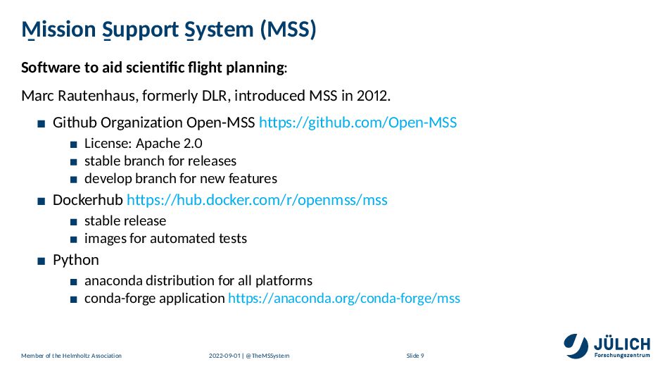
The Mission Support System Software (MSS) is a client/server application developed in the community to collaboratively create flight plans based on model data. Through conda-forge, the components of MSS can be used on different platforms.

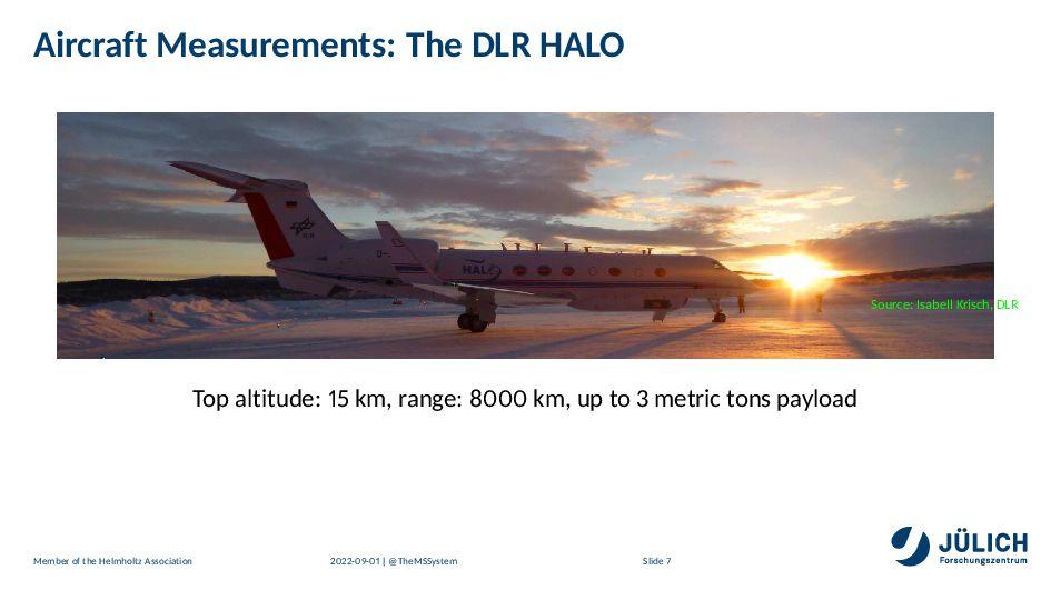
Examining the atmosphere by research aircraft is a costly and highly collaborative effort involving a large community of scientists, their one-of-a-kind measurement instruments and a very limited amount of available flight-hours.
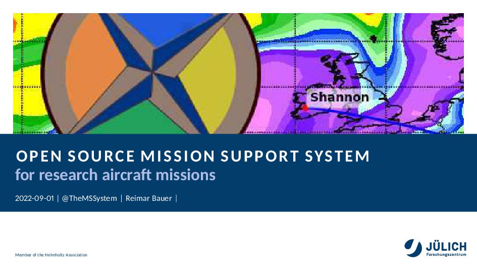
The MSS Software (mss.rtfd.io) is used for planning research aircraft missions. Such missions involve the measurement of interesting atmospheric situation by research aircraft. These missions typically involve a wide range of one-of-a-kind instruments designed and operated by different scientific institution, with different requirements and operational conditions.
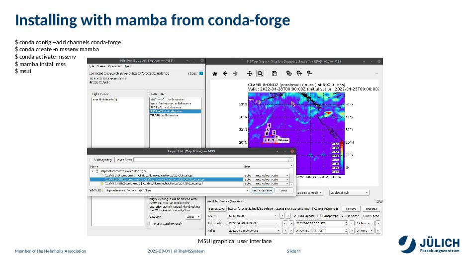
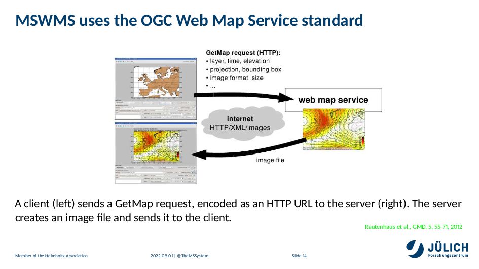
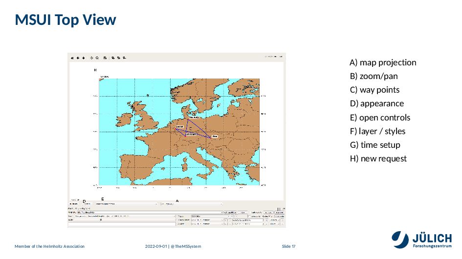
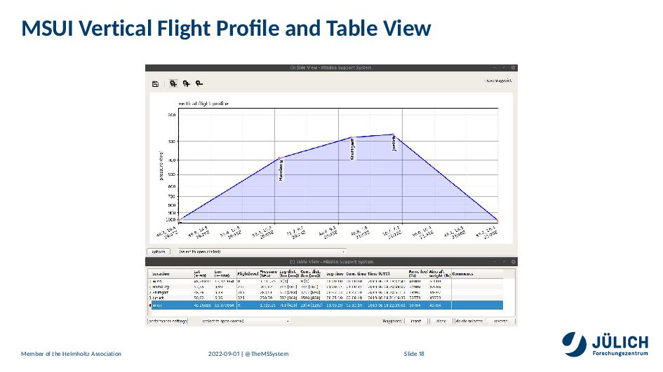
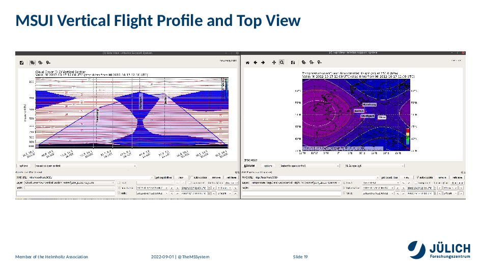
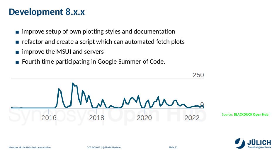
The software project contains several components. Scripts for automated download and process of weather forecast data for the server components. This model forecast data is needed to guide the aircraft to the location of interest. The data is visualized by an extended OGC webmap server capable of visualising the big data generated by complex 3-D atmospheric simulations in a highly configurable manner and delivering the resulting small PNG images over the internet. Another server based on socketIO enables collaborative working from different locations on the same flightpath simultaniously. The flightpath editor is a QT UI that allows to overlay the pictures produced by our server. The flightpath can be changed accordingly vertically and horizontally. We provide also a view based on the simulated data to visualize data similar to an insitu measurement along the flightpath.

Reimar Bauer

September 01, 2022
Tweet

More Decks by Reimar Bauer

Other Decks in Science

Transcript

  1. OPEN SOURCE MISSION SUPPORT SYSTEM
    for research aircraft missions
    - - | @TheMSSystem Reimar Bauer
    Member of the Helmholtz Association

    View Slide

  2. Forschungszentrum Jülich GmbH, Reimar Bauer
    Forschungszentrum Jülich, IEK-
    IEK- conducts research on the chemistry, dynamics and
    microphysics of the stratosphere and the tropopause
    region, and on the role these atmospheric layers play in
    the climate system.
    For this purpose, research aircrafts and balloons are used
    for complex measurements of atmospheric parameters
    intended to clarify processes, primarily on a local and
    regional scale.
    http://www.fz-juelich.de/
    Reimar Bauer
    @ReimarBauer
    IEK-
    PythonCamp
    Python Software Foundation
    Python Software Verband e.V.
    Member of the Helmholtz Association - - | @TheMSSystem Slide

    View Slide

  3. Atmospheric Research – What?
    Understand various individual processes
    and their interplay in the atmosphere
    Source: Artificial Clouds - Reimar Bauer
    Member of the Helmholtz Association - - | @TheMSSystem Slide

    View Slide

  4. Sketch of Atmospheric Processes
    Source: Karlheinz Nogai, FZJ
    Member of the Helmholtz Association - - | @TheMSSystem Slide

    View Slide

  5. Atmospheric Research – AIM
    Improved understanding of the individual processes
    parametrize these processes in atmospheric models, e.g. Chemistry climate models (CCMs)
    and Earth system models (ESMs)
    Quality improvement of models and predictions for ozone hole, climate,...
    Member of the Helmholtz Association - - | @TheMSSystem Slide

    View Slide

  6. Atmospheric Research – HOW?
    Source: Karlheinz Nogai
    Member of the Helmholtz Association - - | @TheMSSystem Slide

    View Slide

  7. Atmospheric Research – Aircraft Measurements
    Flexibility to measure at locations of scientific interest
    Cheap compared to satellite measurements
    Research flight hours are rare and still very expensive
    Collaboration with various groups and institutions that are specialized for individual
    measurements
    Member of the Helmholtz Association - - | @TheMSSystem Slide

    View Slide

  8. Aircraft Measurements: The DLR HALO
    Source: Isabell Krisch, DLR
    Top altitude: km, range: km, up to metric tons payload
    Member of the Helmholtz Association - - | @TheMSSystem Slide

    View Slide

  9. Planning Research Flights - Get all groups satisfied
    Scientific campaigns with flights from a base airport address many scientific questions
    Find the best flight plan for all envolved
    Ground Team for instrument preparation and mounting
    Model simulations for the near future using meteorological forecast data
    Optimization of the scientific outcome by finding the best flight path (in dimensions time,
    latitude, longitude, altitude) in the “model world”
    Consideration of various aircraft constraints (range, flight altitude, overflight permits...)
    Discussion and iteration of the proposed flight plans with pilots and aircraft representatives
    Member of the Helmholtz Association - - | @TheMSSystem Slide

    View Slide

  10. M
    ¯
    ission S
    ¯
    upport S
    ¯
    ystem (MSS)
    Software to aid scientific flight planning:
    Marc Rautenhaus, formerly DLR, introduced MSS in .
    Github Organization Open-MSS https://github.com/Open-MSS
    License: Apache .
    stable branch for releases
    develop branch for new features
    Dockerhub https://hub.docker.com/r/openmss/mss
    stable release
    images for automated tests
    Python
    anaconda distribution for all platforms
    conda-forge application https://anaconda.org/conda-forge/mss
    Member of the Helmholtz Association - - | @TheMSSystem Slide

    View Slide

  11. Documented in GMD
    Bauer, R., Grooß, J.-U., Ungermann, J., Bär, M., Geldenhuys, M., and Hoffmann, L.: The
    Mission Support System (MSS v . . ) and its use in planning for the SouthTRAC aircraft
    campaign, Geosci. Model Dev., https://doi.org/ . /gmd- - , in review, .
    Rautenhaus, M., Bauer, G., and Doernbrack, A.: A web service based tool to plan atmospheric
    research flights, Geosci. Model Dev., , - , doi: . /gmd- - - , .
    http://www.geosci-model-dev.net/ / / /gmd- - - .pdf
    Member of the Helmholtz Association - - | @TheMSSystem Slide

    View Slide

  12. Installing with mamba from conda-forge
    conda config --add channels conda-forge
    conda create -n mssenv mamba
    conda activate mssenv
    mamba install mss
    msui
    MSUI graphical user interface
    Member of the Helmholtz Association - - | @TheMSSystem Slide

    View Slide

  13. MSUI Configuration
    layout sizes of views, immutable sizes
    available map projections
    predefined waypoints
    import/export plugins
    WMS service URLs
    login cedentials
    Member of the Helmholtz Association - - | @TheMSSystem Slide

    View Slide

  14. Architecture of MSS
    Installation includes: MSWMS server, MSColab server, MSUI graphical interface
    Bauer et al., https://doi.org/ . /gmd- - in review
    Member of the Helmholtz Association - - | @TheMSSystem Slide

    View Slide

  15. MSWMS uses the OGC Web Map Service standard
    A client (left) sends a GetMap request, encoded as an HTTP URL to the server (right). The server
    creates an image file and sends it to the client.
    Rautenhaus et al., GMD, , - ,
    Member of the Helmholtz Association - - | @TheMSSystem Slide

    View Slide

  16. MSS helps Solving Complexity of flight planning
    data center provide by the MSWMS server forecast data, e.g. ECMWF
    data center provides a MSColab collaboration server compenent
    The scientists uses a QT GUI client application which can access MSWMS and MSColab
    Servers.
    The scientists accesses the MSWMS server and requests vertical, horizontal, linear views and
    receives generated images.
    Scientists interactively design a flight route in direct relation to atmospheric prediction data.
    The flight route is exchanged to all users using the MSColab collaboration Server
    Way points of a proposed flight route are overlayed on any view of requested data.
    Flightplan based on flight route handed over to pilots and aircraft representatives.
    Member of the Helmholtz Association - - | @TheMSSystem Slide

    View Slide

  17. Campaigns using MSS
    Source: Jens-Uwe Grooss, FZJ
    Member of the Helmholtz Association - - | @TheMSSystem Slide

    View Slide

  18. MSUI Top View
    A) map projection
    B) zoom/pan
    C) way points
    D) appearance
    E) open controls
    F) layer / styles
    G) time setup
    H) new request
    Member of the Helmholtz Association - - | @TheMSSystem Slide

    View Slide

  19. MSUI Vertical Flight Profile and Table View
    Member of the Helmholtz Association - - | @TheMSSystem Slide

    View Slide

  20. MSUI Vertical Flight Profile and Top View
    Member of the Helmholtz Association - - | @TheMSSystem Slide

    View Slide

  21. MSWMS Configurations
    All plots can be defined by python scripts.
    example can be created by mswms_demodata –seed
    use the default plot styles
    create own styles in extra files
    derivate from generics styles
    Member of the Helmholtz Association - - | @TheMSSystem Slide

    View Slide

  22. MSColab
    Features using a MSColab server.
    exchanges data in realtime
    changes of the flightpath are versionized
    used database can be configured
    role concept for permissions
    access to MSColab by rd party software, e.g. windy
    Member of the Helmholtz Association - - | @TheMSSystem Slide

    View Slide

  23. Development .x.x
    improve setup of own plotting styles and documentation
    refactor and create a script which can automated fetch plots
    improve the MSUI and servers
    Fourth time participating in Google Summer of Code.
    Source: BLACKDUCK Open Hub
    Member of the Helmholtz Association - - | @TheMSSystem Slide

    View Slide

  24. Ecosystem
    conda-forge community
    mamba-org community
    anaconda
    pypi
    bitbucket, github
    pycharm, vscode
    pytest
    readthedocs
    dockerhub
    Member of the Helmholtz Association - - | @TheMSSystem Slide

    View Slide

  25. Documentation
    http://mss.rtfd.io
    https://github.com/Open-MSS/MSS/
    https://anaconda.org/conda-forge/mss
    http://www.geosci-model-dev.net/ / / /gmd- - - .pdf
    http://www.geosci-model-dev.net/ / / /gmd- - - -supplement.pdf
    The Mission Support System (MSS v . . ) and its use in planning for the SouthTRAC aircraft
    campaign, Geosci. Model Dev. in review,
    Member of the Helmholtz Association - - | @TheMSSystem Slide

    View Slide