Upgrade to Pro — share decks privately, control downloads, hide ads and more …

The 3rd Quarter GIS Community Meeting of 2020

The 3rd Quarter GIS Community Meeting of 2020

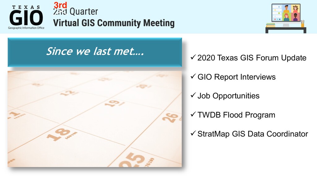
Another successful virtual GIS Community Meeting with 145 attendees. Special guest presentation by Tessellations, Inc. Next meeting scheduled for October 27, 2020.

More Decks by Texas Natural Resources Information System

Transcript

  1. View Slide

  2. Welcome
    Project Updates
    Roll Call
    Tessellations, Inc.
    Audience Q&A
    2:00 – 2:10
    2:10 – 2:40
    2:50 – 3:10
    3:10 – 3:40
    3:40 – 4:00

    View Slide

  3. Since we last met….
    ü 2020 Texas GIS Forum Update
    ü GIO Report Interviews
    ü Job Opportunities
    ü TWDB Flood Program
    ü StratMap GIS Data Coordinator

    View Slide

  4. STRATMAP CONTRACTS RE-BID OF VENDOR POOL
    Schedule
    • Request for Offer opened Dec. 20, 2019
    • Vendor submissions due Feb. 21, 2020
    • New vendor pool Early Fall 2020
    Geospatial Data, Services & Software

    View Slide

  5. TEXAS IMAGERY SERVICE
    • Aerial imagery from Google.
    • New imagery provider coming Sept 1!
    • 6-inch pixel resolution
    • Statewide coverage
    • 2011 - present
    • Automatic Imagery Updates
    • Entire state refreshed every 3-4 years
    • Streaming data service
    • WMTS/WMS links
    • Annual subscription fee
    • Join any time at prorated fee

    View Slide

  6. TEXAS IMAGERY SERVICE
    • Image updates from Google will end 
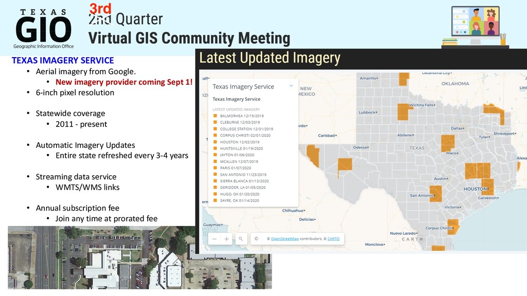
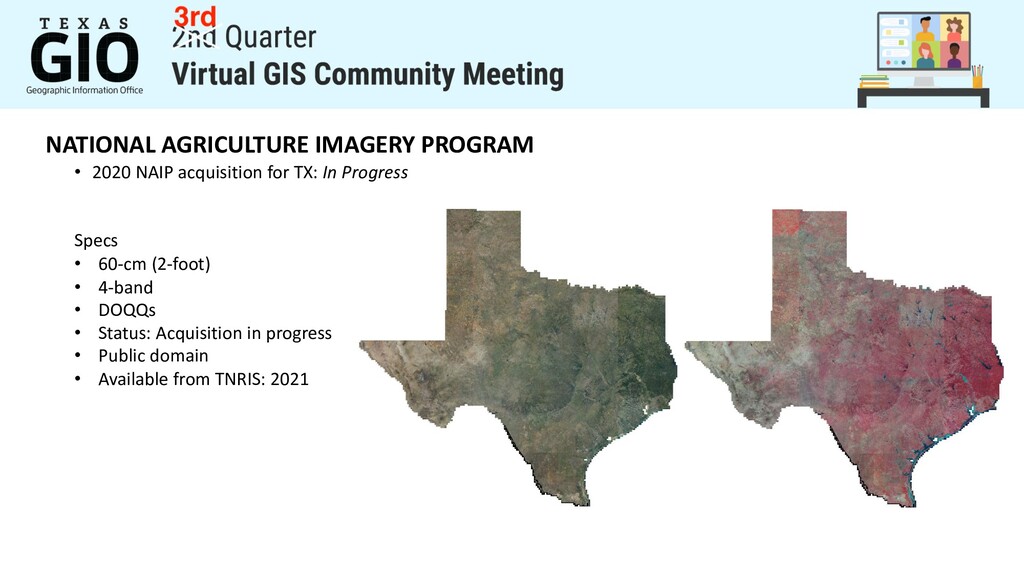
August 31, 2020
    • Continued access to all past imagery
    • New imagery content coming September 2020 from and
    • Statewide 2018 imagery will refresh rural areas
    • Statewide 2020 imagery coming early 2021

    View Slide

  7. TEXAS IMAGERY SERVICE
    Cost Model
    • No change
    • Plan budgets for FY2021 same as current
    https://www.tnris.org/google-request/

    View Slide

  8. NATIONAL AGRICULTURE IMAGERY PROGRAM
    • 2020 NAIP acquisition for TX: In Progress
    Specs
    • 60-cm (2-foot)
    • 4-band
    • DOQQs
    • Status: Acquisition in progress
    • Public domain
    • Available from TNRIS: 2021

    View Slide

  9. 2020 CAPITAL AREA / McLENNAN CO
    • 3-inch / 6-inch / 1-foot
    • 4-band
    • DO4Qs (.jp2)
    • Status: Delivered
    • Available: Aug 2020

    View Slide

  10. Texas Lidar Coverage 2020
    Statewide Lidar Coverage Update for Texas
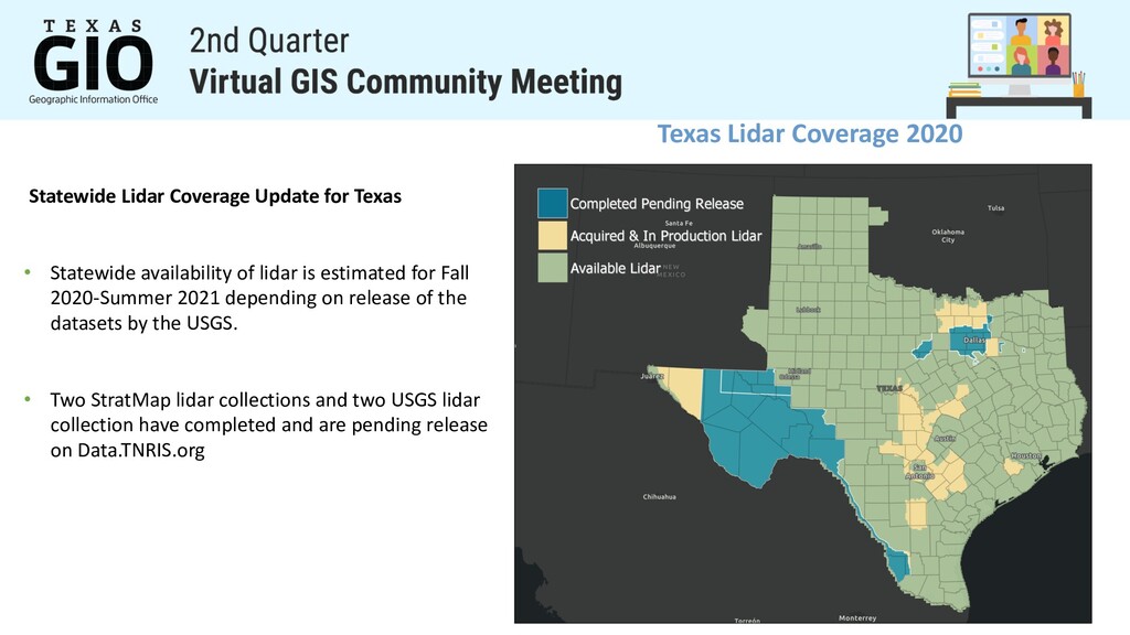
    • Statewide availability of lidar is estimated for Fall
    2020-Summer 2021 depending on release of the
    datasets by the USGS.
    • Two StratMap lidar collections and two USGS lidar
    collection have completed and are pending release
    on Data.TNRIS.org

    View Slide

  11. StratMap Winter 2020-2021 Season
    Central Texas Region Data Acquisition
    for 
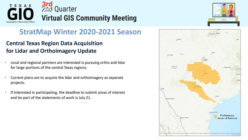
Lidar and Orthoimagery Update
    • Local and regional partners are interested is pursuing ortho and lidar
    for large portions of the central Texas regions.
    • Current plans are to acquire the lidar and orthoimagery as separate
    projects.
    • If interested in participating, the deadline to submit areas of interest
    and be part of the statements of work is July 21.

    View Slide

  12. StratMap Data Initiatives on the Horizon
    • Full Classification of Federal Lidar Projects.
    Ø Statement of work is in formal review and is anticipated for
    release in the coming months
    • High Quality Bathymetric Data for Rivers Coastal Bays
    Ø Ongoing efforts to coordinate and define area of interest in
    coastal bay areas for pilot project. Currently evaluating an AOI
    over the Trinity and Galveston Bay areas.
    Ø Currently coordinating and planning data development in
    Texas with NOAA,TPWD,NRCS,TWDB, and USGS.
    Ø Elevation Derived Hydrography (Ele-Hydro)
    Ø Ideally will be coordinated to occur with or post inland
    bathymetry data collection or recent Lidar collections
    Ø USGS has released specifications for Ele-Hydro data
    collection(https://www.usgs.gov/news/usgs-
    specifications-deriving-hydrography-elevation-data-are-
    now-available)
    A StratMap Funded Project

    View Slide

  13. View Slide

  14. Historic Imagery Bulk Scanning Project
    StratMap is currently reviewing proposals 
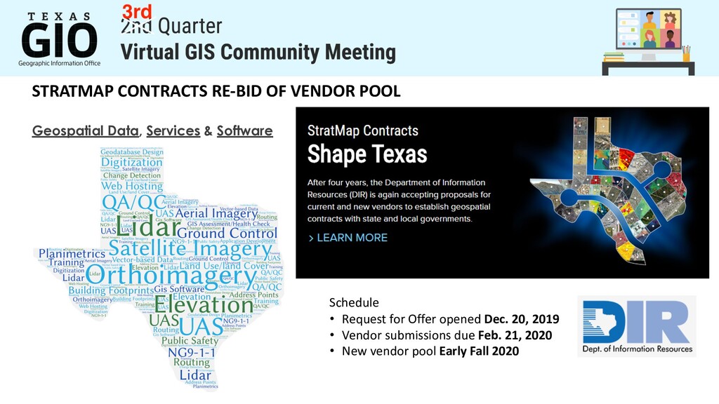
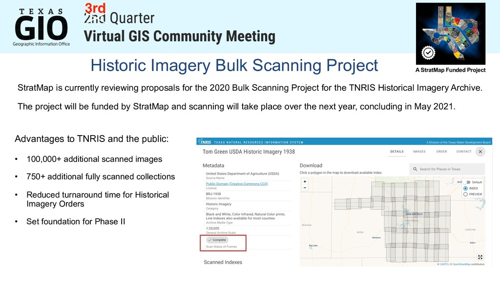
for the 2020 Bulk Scanning Project for the TNRIS Historical Imagery Archive.
    The project will be funded by StratMap and scanning will take place over the next year, concluding in May 2021.
    Advantages to TNRIS and the public:
    • 100,000+ additional scanned images
    • 750+ additional fully scanned collections
    • Reduced turnaround time for Historical
    Imagery Orders
    • Set foundation for Phase II
    A StratMap Funded Project

    View Slide

  15. 7/17/17

    View Slide

  16. Geospatial Technology Services
    Texas General Land Office
    George P. Bush Commissioner

    View Slide

  17. Texas Parks & Wildlife Department
    • Establishment of internal TPWD GIS Workgroup
    • Consolidating all TPWD ESRI customer numbers (9) into one
    Agency account
    • Merging 4 AGO subscriptions into one Agency AGO
    account

    View Slide

  18. View Slide

  19. SWIGGIS
    0 7 / 2 3 T H : S W I G G I S & U R I S A T X
    V I R T U A L T R I V I A N I G H T ( E S R I U C )
    D E T A I L S & R S V P :
    H T T P S : / / W W W . U R I S A T E X A S . O R G / E V E N T - 3 8 7 4 2 6 8
    U P C O M I N G : G I S P W O R K S H O P &
    V I R T U A L I N T E R V I E W S P A N E L
    O P E N O F F I C E R P O S I T I O N S & W E L C O M I N G M E M B E R S
    S W I G G I S . A U S T I N @ G M A I L . C O M
    C o n n e c t w i t h S W I G G I S
    s w i g g i s . o r g | M e e t u p . c o m | L i n k e d I n . c o m | T w i t t e r

    View Slide

  20. Working with Real Time Traffic Data: Update, Visualize,
    Analyze and LinkIT with Reports
    Presented by Trey Nunn [email protected]

    View Slide

  21. 8505 Technology Forest Place, Suite 1104, The Woodlands, Texas 77381
    www.tessellations.us
    Working with Real Time Traffic Data
    Update, Visualize, Analyze and LinkIT with Reports
    Presenter: Trey Nunn
    July 21, 2020

    View Slide

  22. Tessellations Inc.
    ►GIS services for the past 22 years
    ►Support full stack of Esri products – Desktop, Enterprise, ArcGIS
    Online
    ►Software development, data management and manipulation,
    image processing, business intelligence and training
    ►Oil and Gas, Local and State government
    ►Partners – Esri, Safe software (FME), Planet and Microsoft

    View Slide

  23. Austin Real Time Traffic Incidents -
    Process
    Update
    Visualize
    Analyze
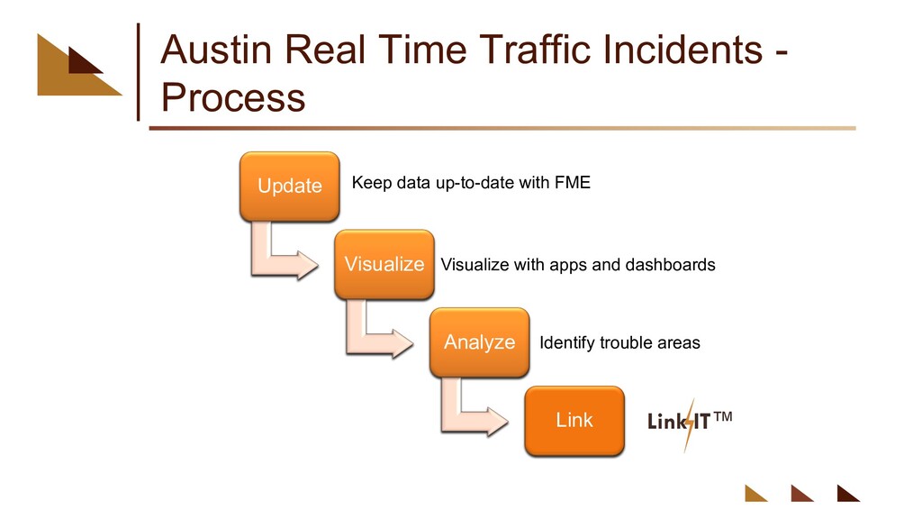
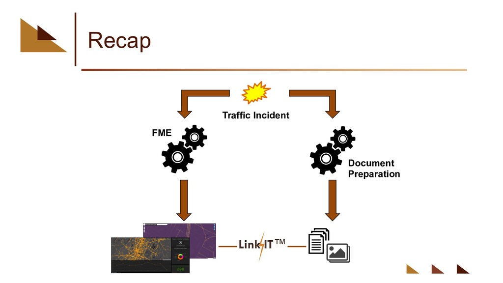
    Link
    Keep data up-to-date with FME
    Visualize with apps and dashboards
    Identify trouble areas
    Update
    Visualize
    Analyze
    Link
    Update
    Visualize
    Analyze
    Link
    Update
    Visualize
    Analyze
    Link

    View Slide

  24. What is FME?
    ►FME – Feature Manipulation Engine
    ►ETL Capabilities
    ►Connect to over 450 formats and applications
    ►Transform and manipulate content
    ►Automate workflows to run on regular schedules

    View Slide

  25. Austin Traffic Incidents
    FME Tasks
    Download Data
    Spatialize
    & Format
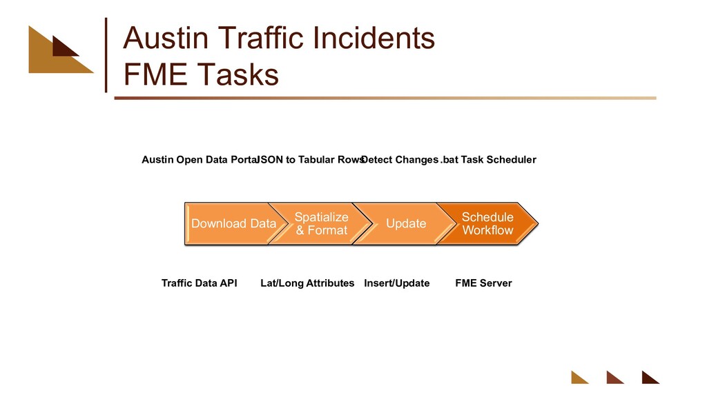
    Update
    Schedule
    Workflow
    Download Data
    Spatialize
    & Format
    Update
    Schedule
    Workflow
    Download Data
    Spatialize
    & Format
    Update
    Schedule
    Workflow
    Download Data
    Spatialize
    & Format
    Schedule
    Workflow
    Update
    Austin Open Data Portal
    Traffic Data API
    JSON to Tabular Rows
    Lat/Long Attributes
    Detect Changes
    Insert/Update
    .bat Task Scheduler
    FME Server

    View Slide

  26. Let’s take a look…

    View Slide

  27. FME Work Bench

    View Slide

  28. Download Data

    View Slide

  29. Create Feature and Update Feature
    Class

    View Slide

  30. Traffic Incident Dashboard

    View Slide

  31. Traffic Incidents – By Month

    View Slide

  32. View Active Incidents Only

    View Slide

  33. Filter by Issue Reported

    View Slide

  34. Further Filter by Selecting Dates

    View Slide

  35. Kernel Density Analysis
    Analyzing Collision Traffic Incidents

    View Slide

  36. Street Hotspot Analysis

    View Slide

  37. LinkIT

    View Slide

  38. Traffic Incident Documents

    View Slide

  39. No Documents Linked…Yet

    View Slide

  40. Update Index

    View Slide

  41. Documents Linked

    View Slide

  42. Recap
    Traffic Incident
    FME
    Document
    Preparation

    View Slide

  43. Q&A
    Trey Nunn Beni Patel
    936-321-1998 713-927-7062
    [email protected] [email protected]
    Launching….
    Tessel Bytes
    Esri tutorials – short 2-5 minutes
    email Hugh if you want the link
    [email protected]
    Or visit our website
    www.tessellations.us

    View Slide

  44. View Slide

  45. Next Meeting
    October
    27
    Tuesday

    View Slide