Upgrade to Pro — share decks privately, control downloads, hide ads and more …

StratMap Celebrating Successful Public and Private Partnerships

StratMap Celebrating Successful Public and Private Partnerships

More Decks by Texas Natural Resources Information System

Other Decks in Technology

Transcript

  1. Statute Texas Water Code Sec. 16.021. TEXAS NATURAL RESOURCES INFORMATION

    SYSTEM. (c) The executive administrator shall designate the director of the Texas Natural Resources Information System to serve as the state geographic information officer. The state geographic information officer shall: (1) coordinate the acquisition and use of high-priority imagery and data sets; (2) establish, support, and disseminate authoritative statewide geographic data sets; (3) support geographic data needs of emergency management responders during emergencies; (4) monitor trends in geographic information technology; and (5) support public access to state geographic data and resources. Sec. 16.017. TOPOGRAPHIC AND GEOLOGIC MAPPING. (a) The executive administrator shall carry out the program for topographic and geologic mapping of the state. (b) The executive administrator shall operate as part of the Texas Natural Resources Information System a strategic mapping program to acquire, store, and distribute digital, geospatial information.
  2. • Maintain authoritative, trusted state geospatial layers based on national

    standards. ü Acquire new geospatial data ü Update existing geospatial data • Define a common mapping standard to ensure consistent, high quality data for the State of Texas and the public. • Attract partnerships to increase the purchasing power of public funds.
  3. TNRIS Agency 2 Agency 4 Agency 3 Agency 1 Provider

    Pre-2009: No master contract for GIS
  4. “I don’t know if I’d want to do this job

    without a master contract.” Joey Thomas, TNRIS Elevation Specialist “Me either!” Gayla Mullins, TNRIS StratMap Manager
  5. StratMap Contracts Partners 73 Agencies • Bandera County River Authority

    and Groundwater District • Bexar County Appraisal District • Bexar Metro 9-1-1 • Brazos Central Appraisal District • Brazos County Emergency Communications • Brownsville Public Utility Board • Capital Area Emergency Communications District • Central Texas Council of Governments • City of Austin • City of Bastrop • City of Bee Cave • City of Bryan • City of Burnet • City of Cedar Park • City of College Station • City of Georgetown • City of Houston • City of Hutto • City of Laredo • City of Leander • City of Lockhart • City of Marble Falls • City of McAllen • City of Palestine • City of Pflugerville • City of Pharr • City of Port Isabel • City of Round Rock • City of San Antonio • City of San Marcos • City of Tyler • City of Waco • City of Weslaco • City of West Lake Hills • East Texas Council of Governments • Edwards Aquifer Authority • Fort Bend County Drainage District • Hays County • Hidalgo County Drainage District #1 • Hidalgo County Metropolitan Planning Organization • Hidalgo County Regional Mobility Authority • Houston-Galveston Area Council • Laguna Madre Water District • Lower Rio Grande Valley Development Council • McLennan County • McLennan County 9-1-1 • Missouri City • National Geospatial-Intelligence Agency • Railroad Commission of Texas • Sabine River Authority • San Antonio River Authority • Smith County • Smith County 9-1-1 • Smith County Appraisal District • Tarrant Regional Water District • Texas A&M University • Texas Commission on Environmental Quality • Texas Commission on State Emergency Communications • Texas Department of Transportation • Texas Eastern 9-1-1 • Texas Forest Service • Texas General Land Office • Texas Municipal Power Agency • Texas Parks and Wildlife Department • Texas Water Development Board • Travis County • Trinity River Authority • University Lands • U.S. Army Corps of Engineers • U.S. Fish & Wildlife Service • U.S. Geological Survey • USDA Natural Resources Conservation Service • Williamson County State Agency Local/Municipality Regional Agency Federal Agency
  6. Initiated/held by Department of Information Resources Administered by TWDB-TNRIS •

    Pool resources • Lower cost per entity • Higher quality service • Save time – no individual procurements Established 2016 Expires 2020 Today: Master contract for GIS
  7. 90 222 289 446 5296 2961 0 1000 2000 3000

    4000 5000 6000 FY2017 FY2018 FY2019 # of Purchases GIS Data & Services GIS Software $3,127,673 $7,548,222 $2,782,956 $1,869,208 $13,651,509 $8,374,186 $- $2,000,000 $4,000,000 $6,000,000 $8,000,000 $10,000,000 $12,000,000 $14,000,000 $16,000,000 FY2017 FY2018 FY2019 $ Purchase Totals GIS Data & Services GIS Software 221 686 315 310 4818 2935 0 1000 2000 3000 4000 5000 6000 FY2017 FY2018 FY2019 # of Purchases per Customer Type State Agency Local/Regional Government Today: Master contract for GIS
  8. 2009 – 2019 StratMap Master Contract Lidar Projects 25 Lidar

    Projects with over 25 agency partnerships Over 58,500 square miles of data More than $14,000,000.00 in projects Over 28 TB of Publicly Available, Free Data
  9. 2009 – 2019 StratMap Master Contract Orthoimagery Projects 16 Orthoimagery

    Projects with over 61 agency partnerships Over 330,000 square miles of data More than $6,500,000.00 in projects Over 3.5 TB of Publicly Available, Free Data
  10. 2009 – 2019 StratMap Agency Partnerships üFederal- 12 üState- 68

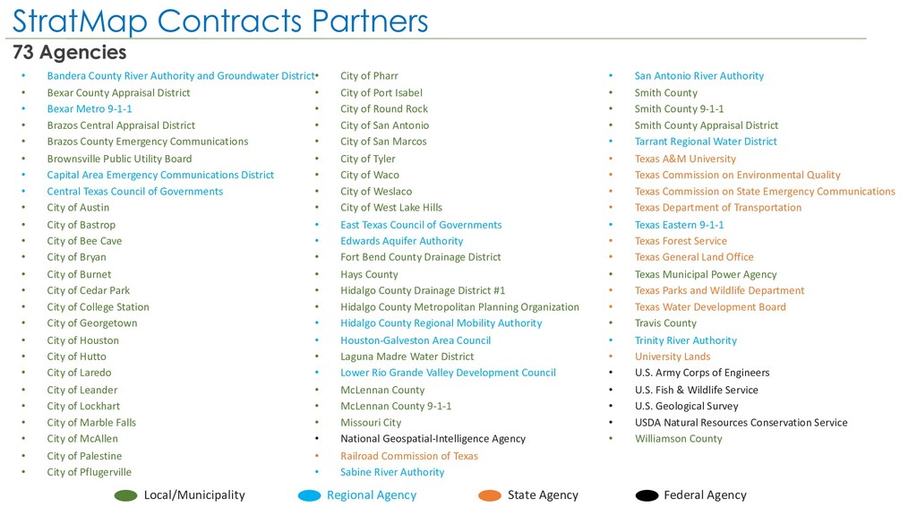
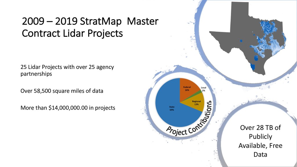
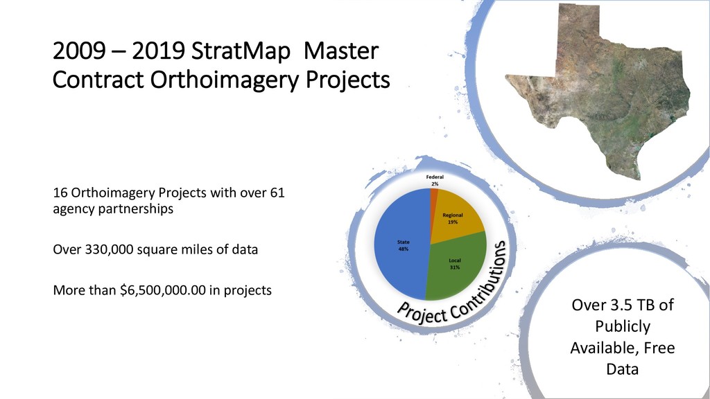
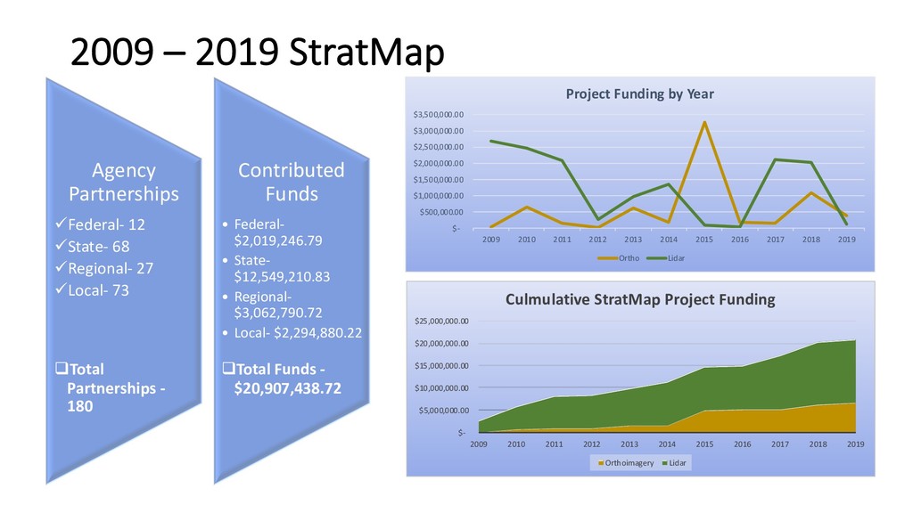
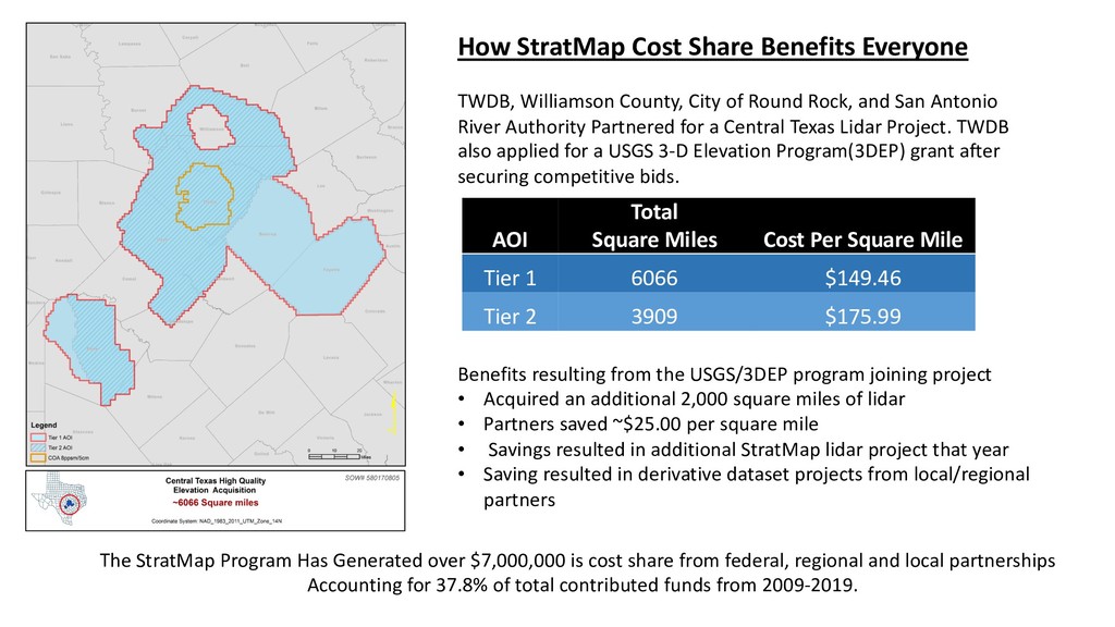
    üRegional- 27 üLocal- 73 qTotal Partnerships - 180 Contributed Funds • Federal- $2,019,246.79 • State- $12,549,210.83 • Regional- $3,062,790.72 • Local- $2,294,880.22 qTotal Funds - $20,907,438.72 $- $5,000,000.00 $10,000,000.00 $15,000,000.00 $20,000,000.00 $25,000,000.00 2009 2010 2011 2012 2013 2014 2015 2016 2017 2018 2019 Culmulative StratMap Project Funding Orthoimagery Lidar $- $500,000.00 $1,000,000.00 $1,500,000.00 $2,000,000.00 $2,500,000.00 $3,000,000.00 $3,500,000.00 2009 2010 2011 2012 2013 2014 2015 2016 2017 2018 2019 Project Funding by Year Ortho Lidar
  11. The StratMap Program Has Generated over $7,000,000 is cost share

    from federal, regional and local partnerships Accounting for 37.8% of total contributed funds from 2009-2019. How StratMap Cost Share Benefits Everyone TWDB, Williamson County, City of Round Rock, and San Antonio River Authority Partnered for a Central Texas Lidar Project. TWDB also applied for a USGS 3-D Elevation Program(3DEP) grant after securing competitive bids. AOI Total Square Miles Cost Per Square Mile Tier 1 6066 $149.46 Tier 2 3909 $175.99 Benefits resulting from the USGS/3DEP program joining project • Acquired an additional 2,000 square miles of lidar • Partners saved ~$25.00 per square mile • Savings resulted in additional StratMap lidar project that year • Saving resulted in derivative dataset projects from local/regional partners
  12. What’s next? Feedback requested: • Expansion of this model •

    What can we do to help you? • What are your pain points? • How can the contracting model help you as a user or as a provider? • What do you want to see on the contract that's different? • What improvements could be made?