Upgrade to Pro — share decks privately, control downloads, hide ads and more …

Groundwater Potential and Quality Assessment in Slums Area, Bima City, West Nusa Tenggara, Indonesia

Groundwater Potential and Quality Assessment in Slums Area, Bima City, West Nusa Tenggara, Indonesia

Groundwater Potential and Quality Assessment
in Slums Area, Bima City, West Nusa Tenggara,
Indonesia

Version 1 (seminar)

Student: PASCALIA VINCA ALVANDO 22719305
Program: Groundwater Engineering Master’s Program, Faculty of Earth Sciences and Technology, Bandung Institute of Technology
Supervisors: Dr. Dasapta Erwin Irawan, Dr. Faizal Rochmat

Abstrak
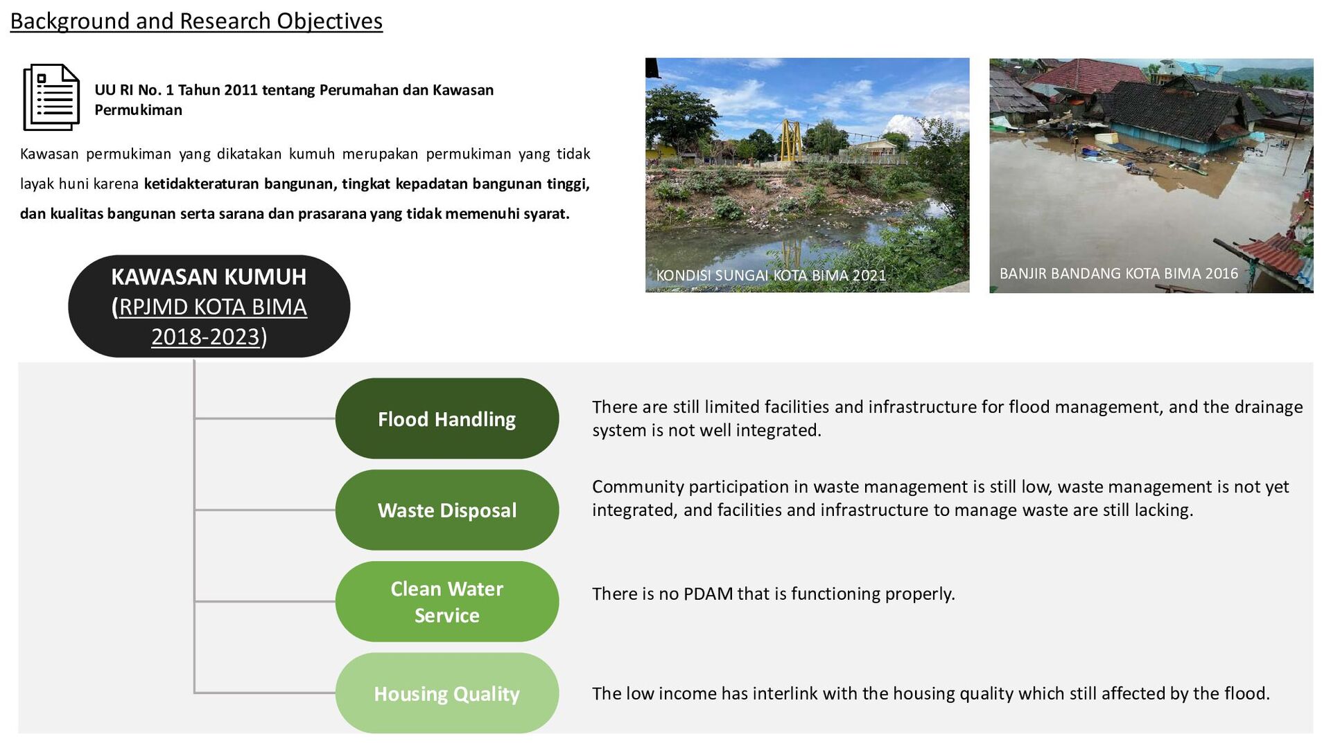
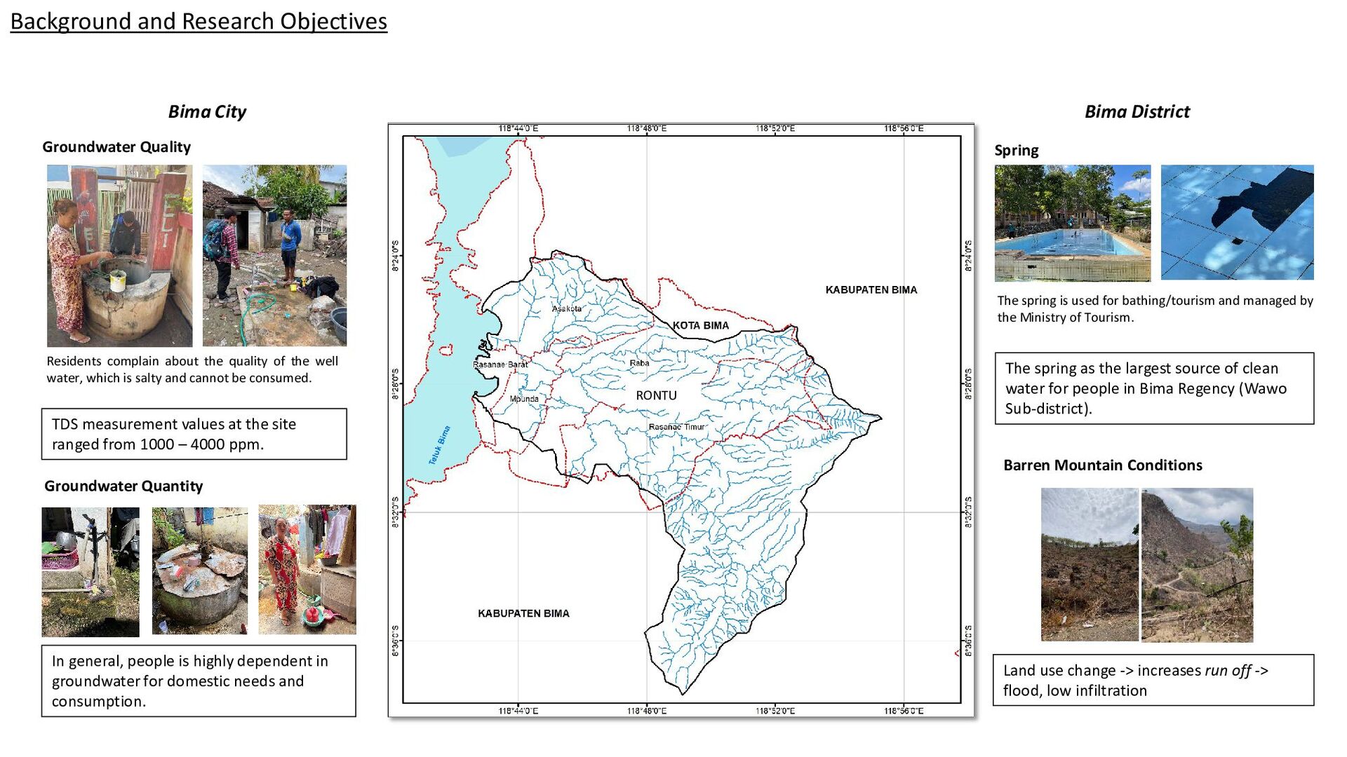
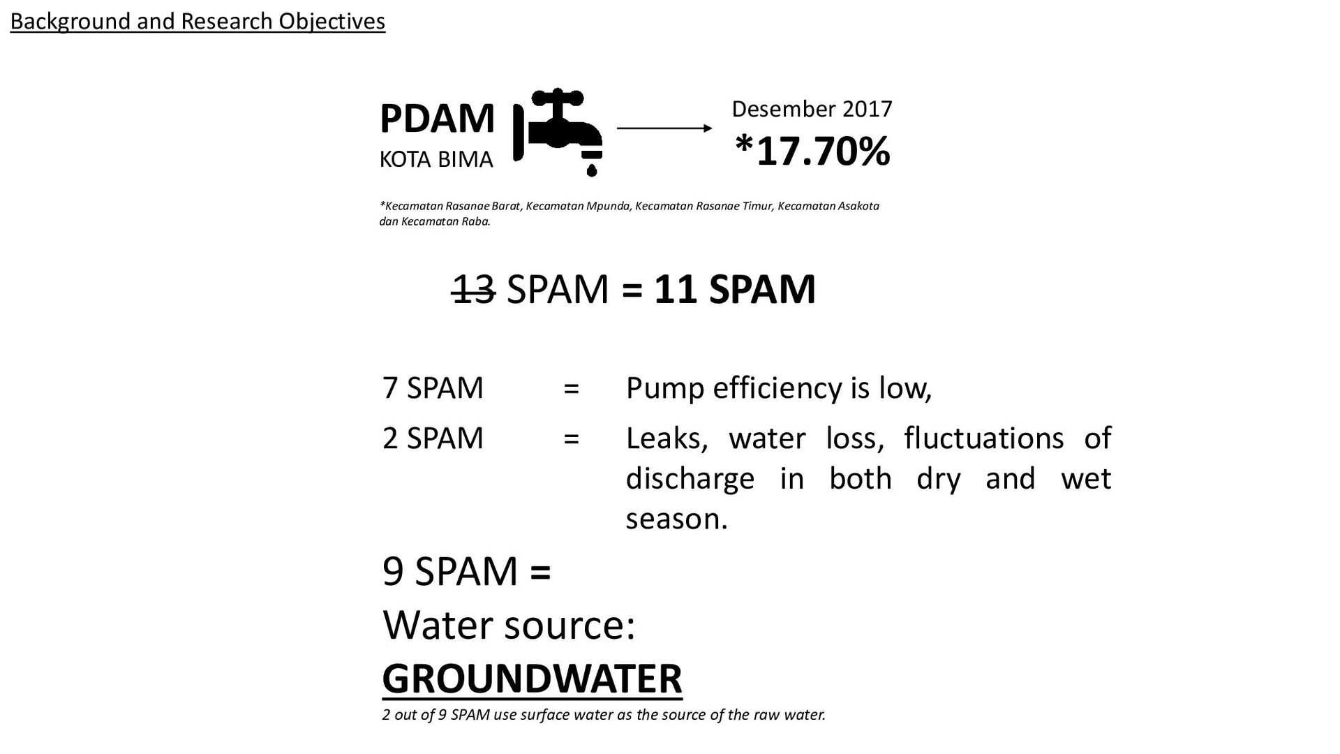
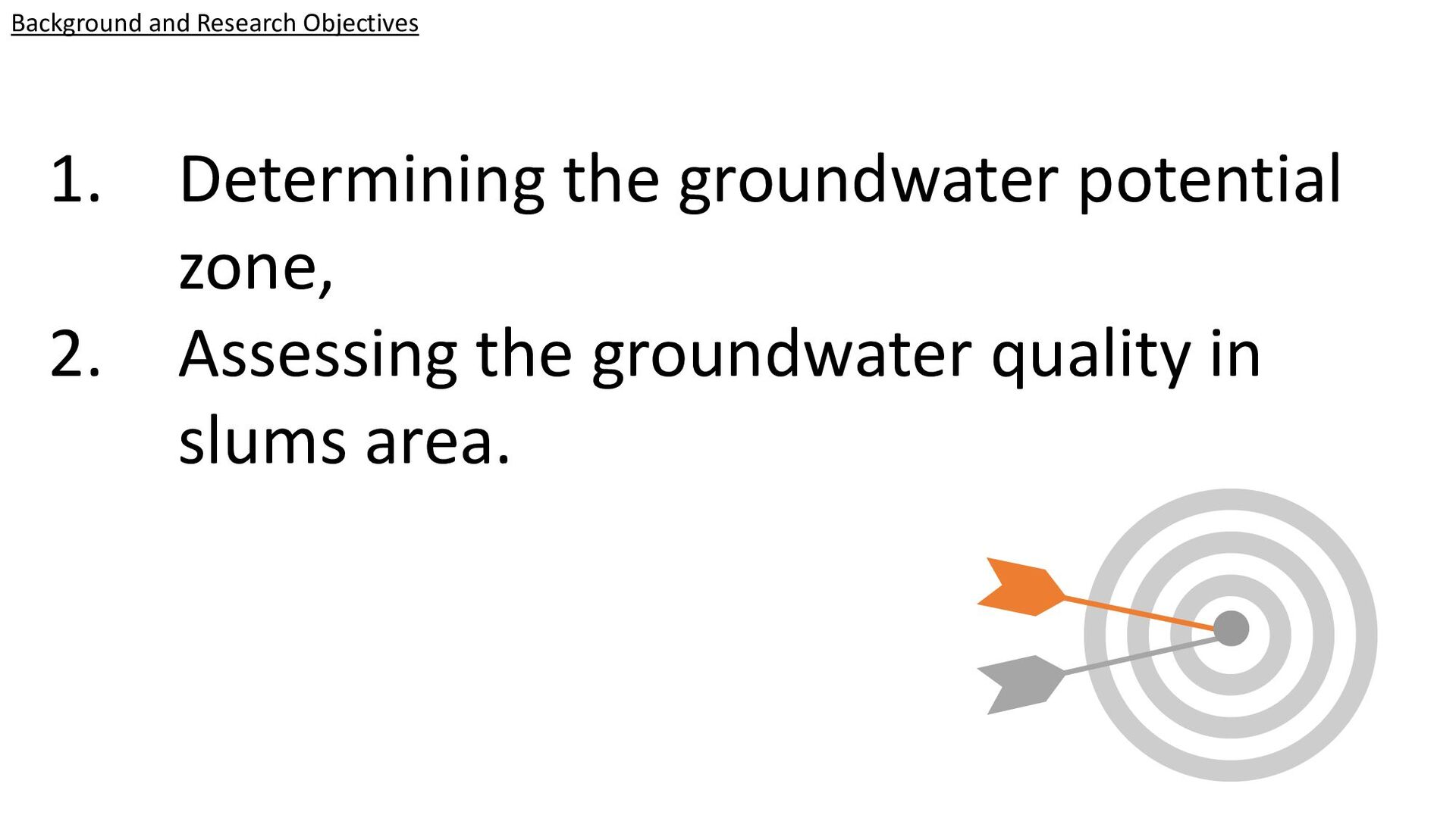
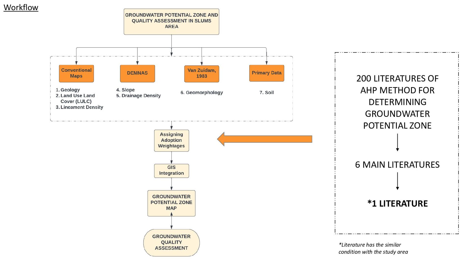
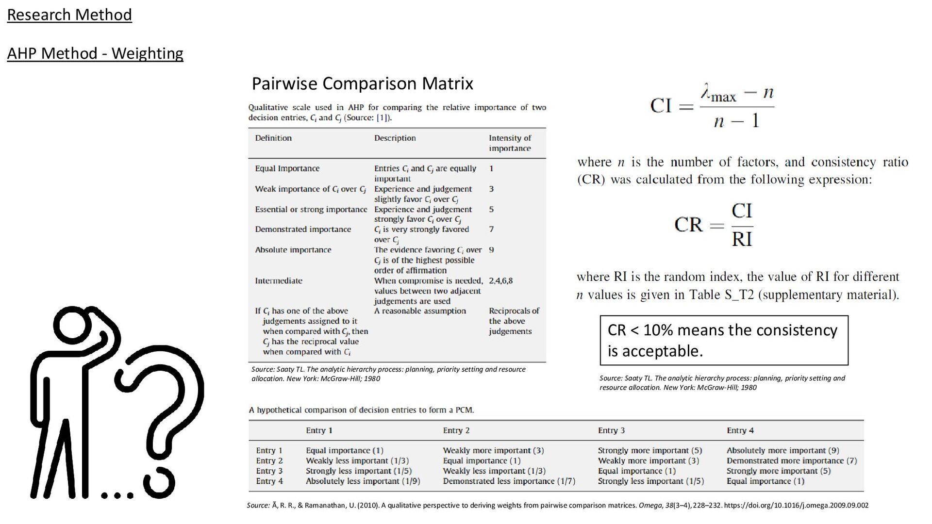
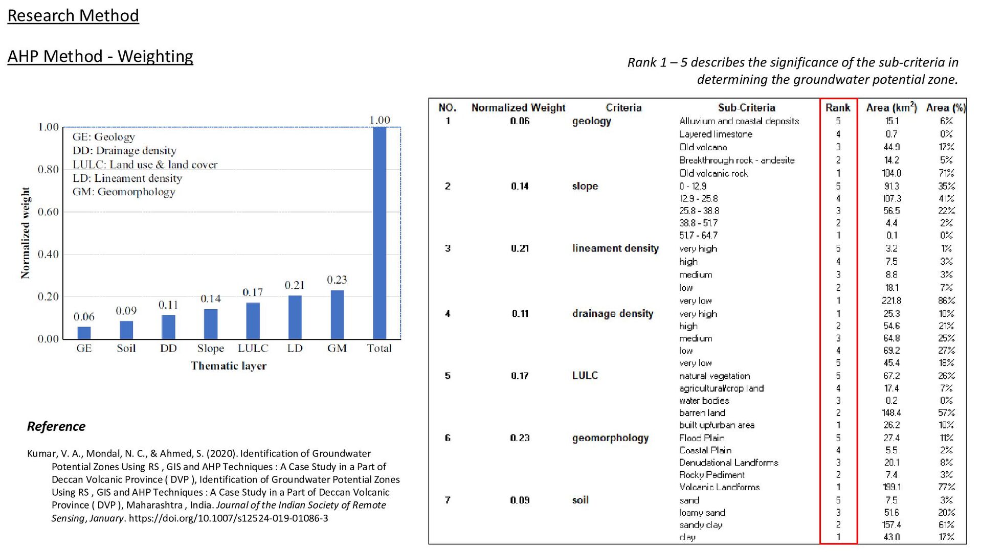
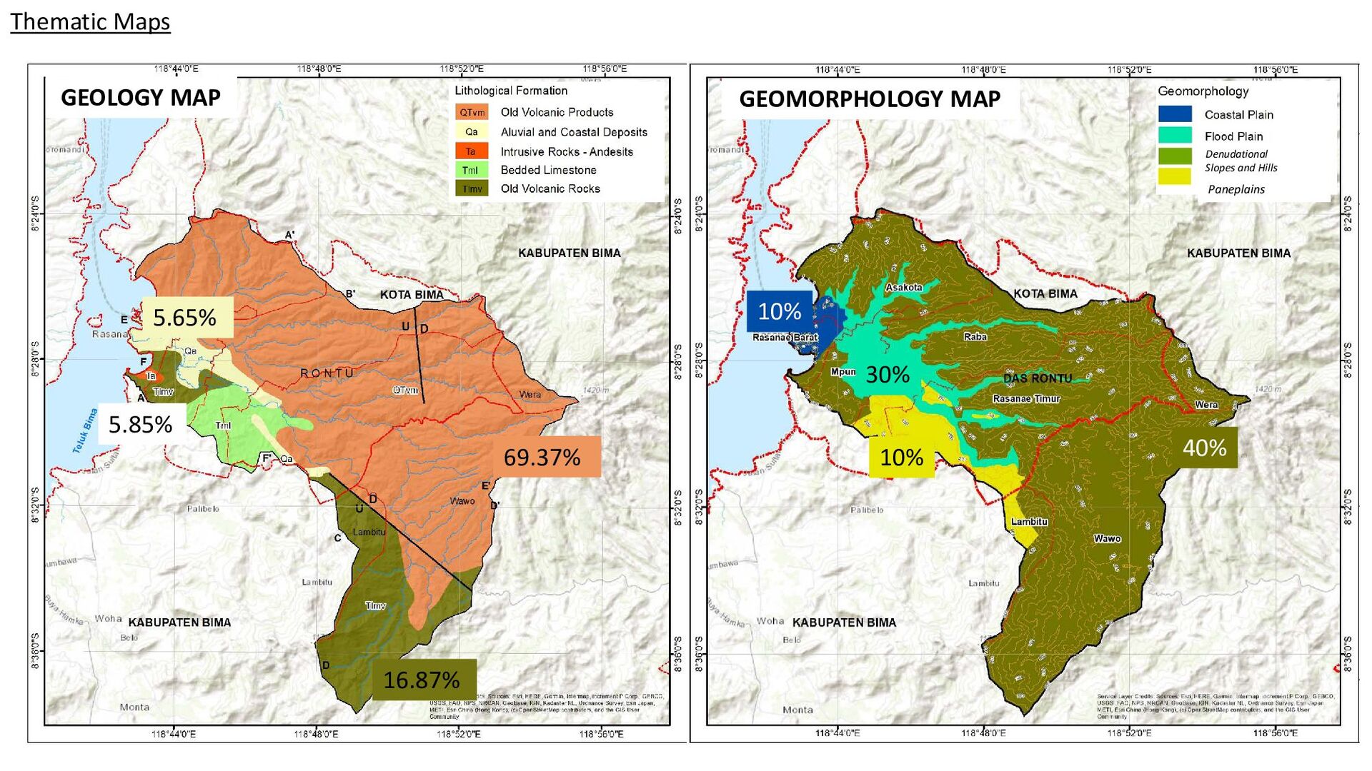
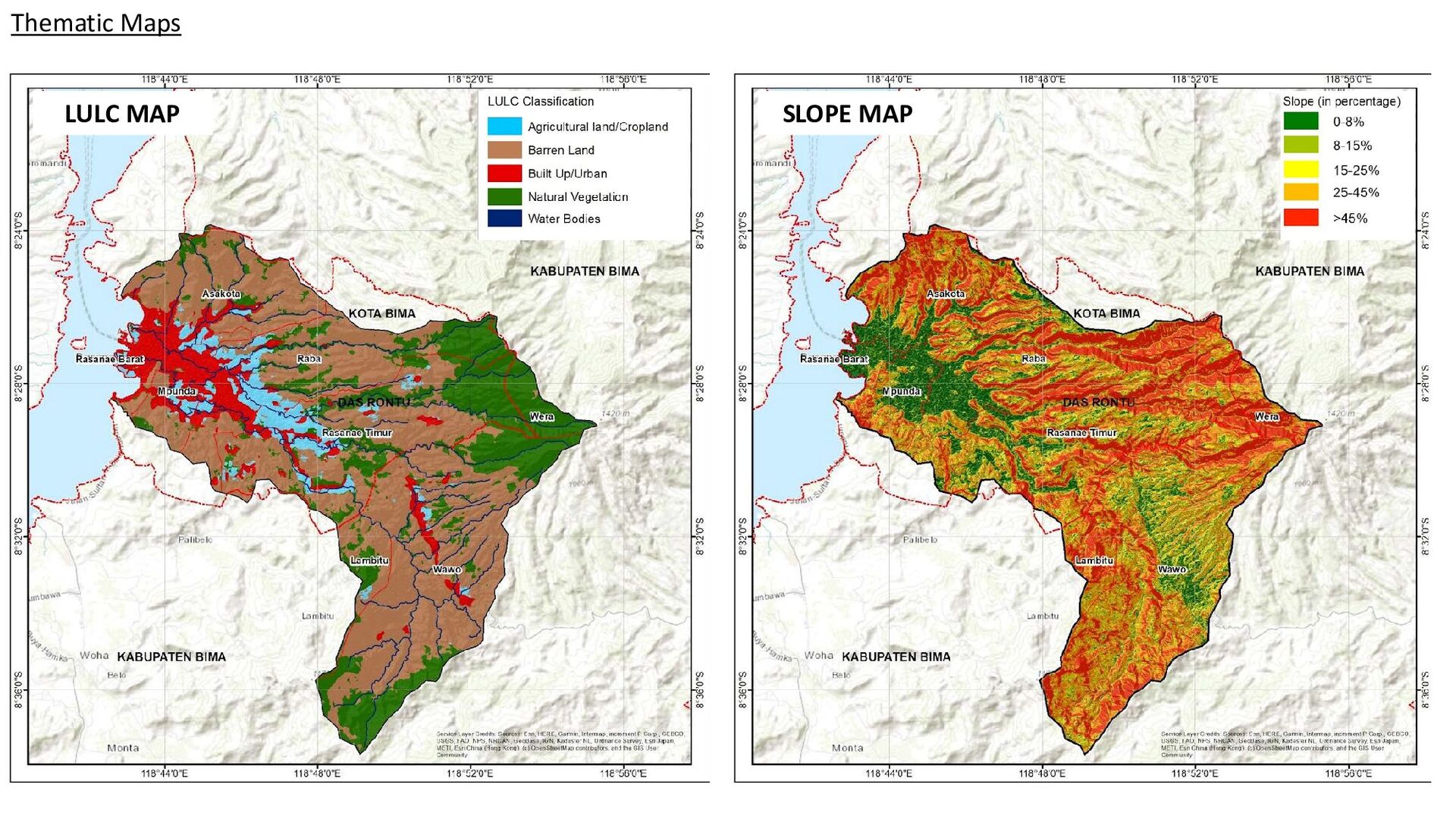
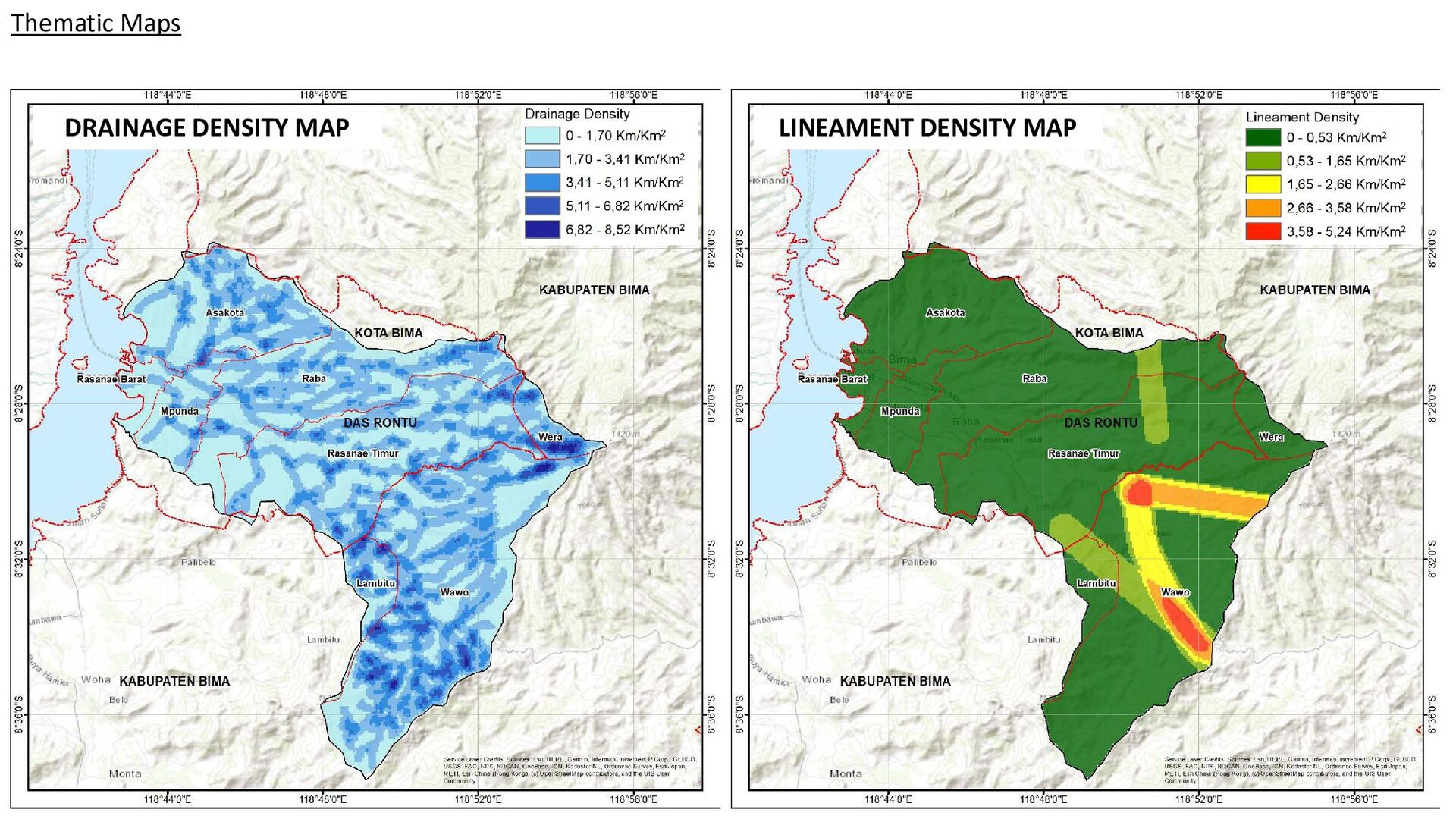
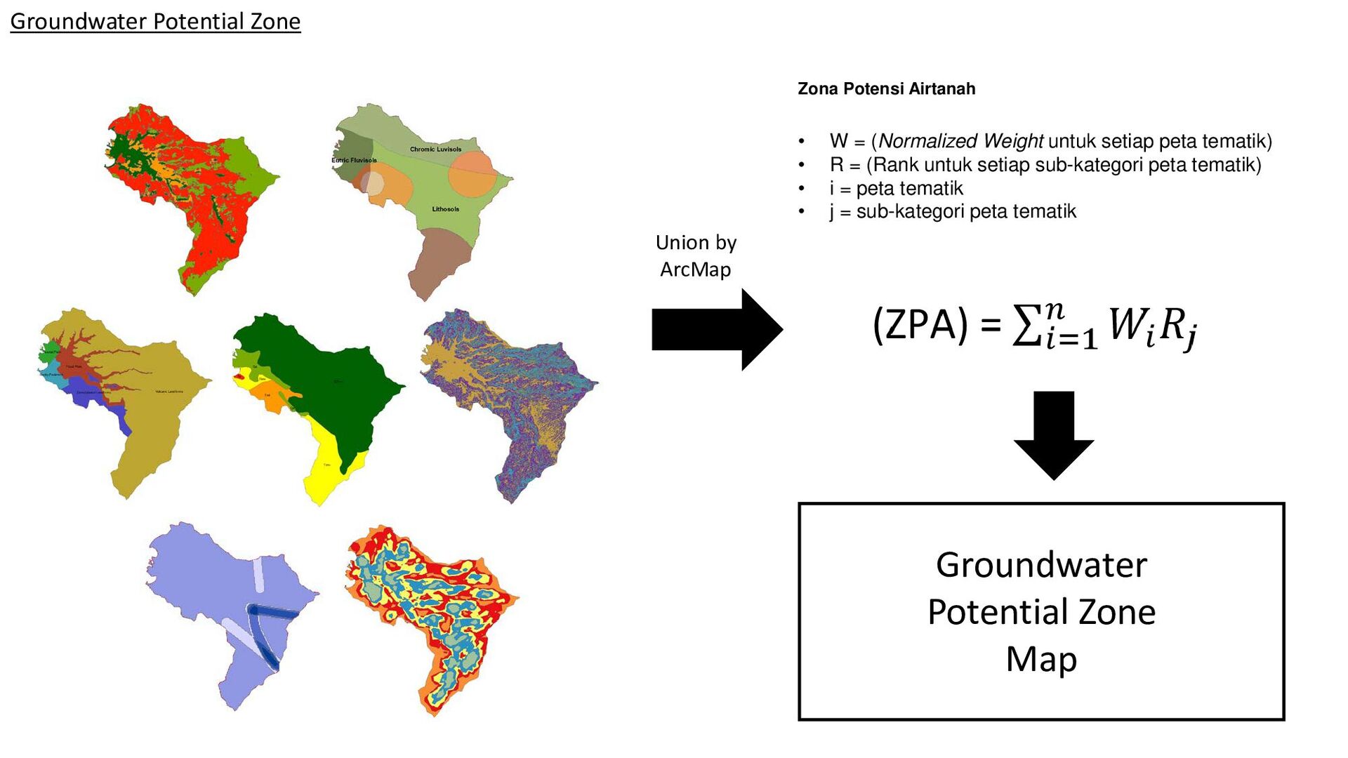
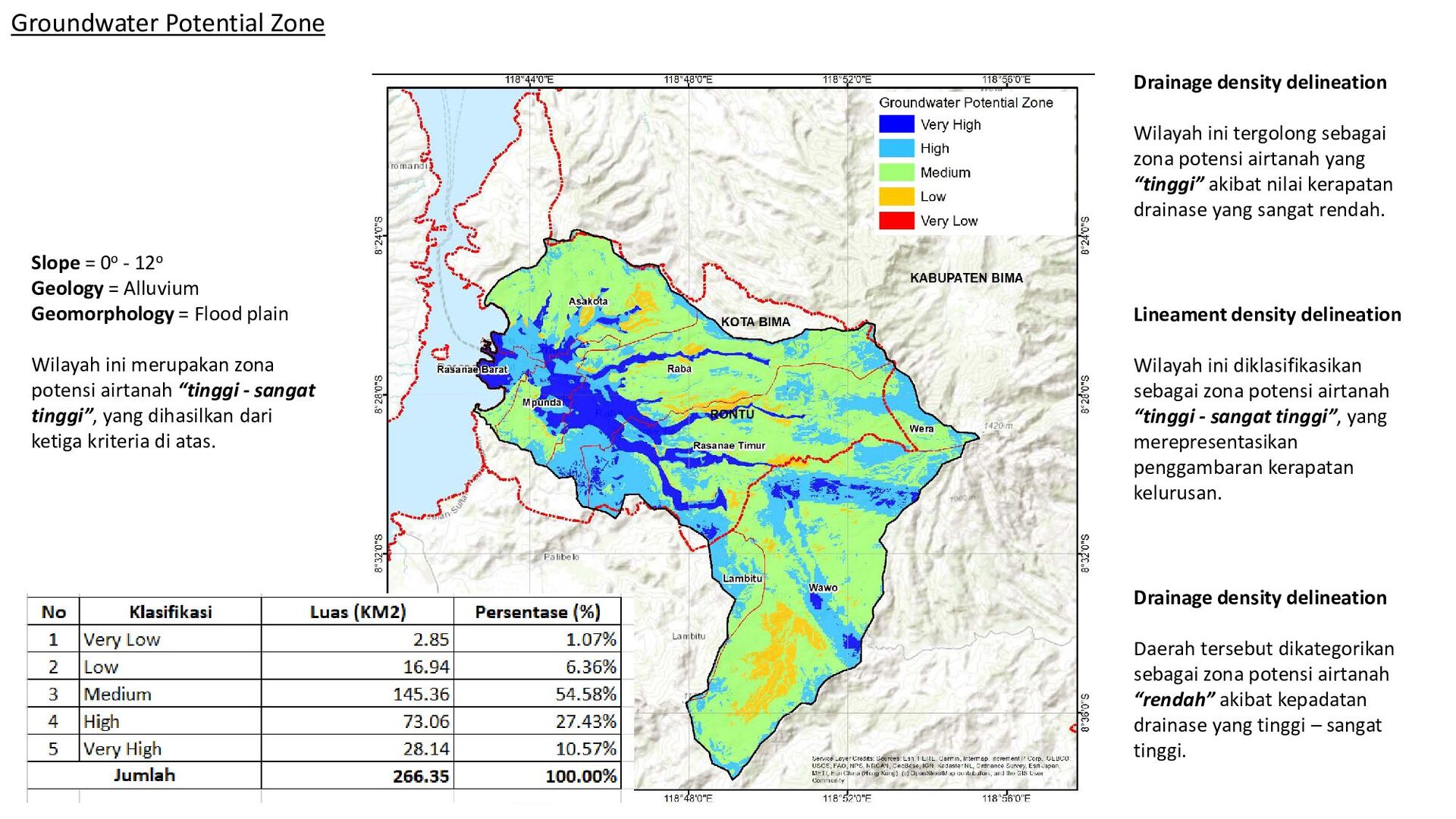
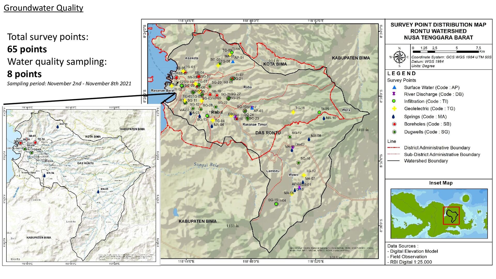
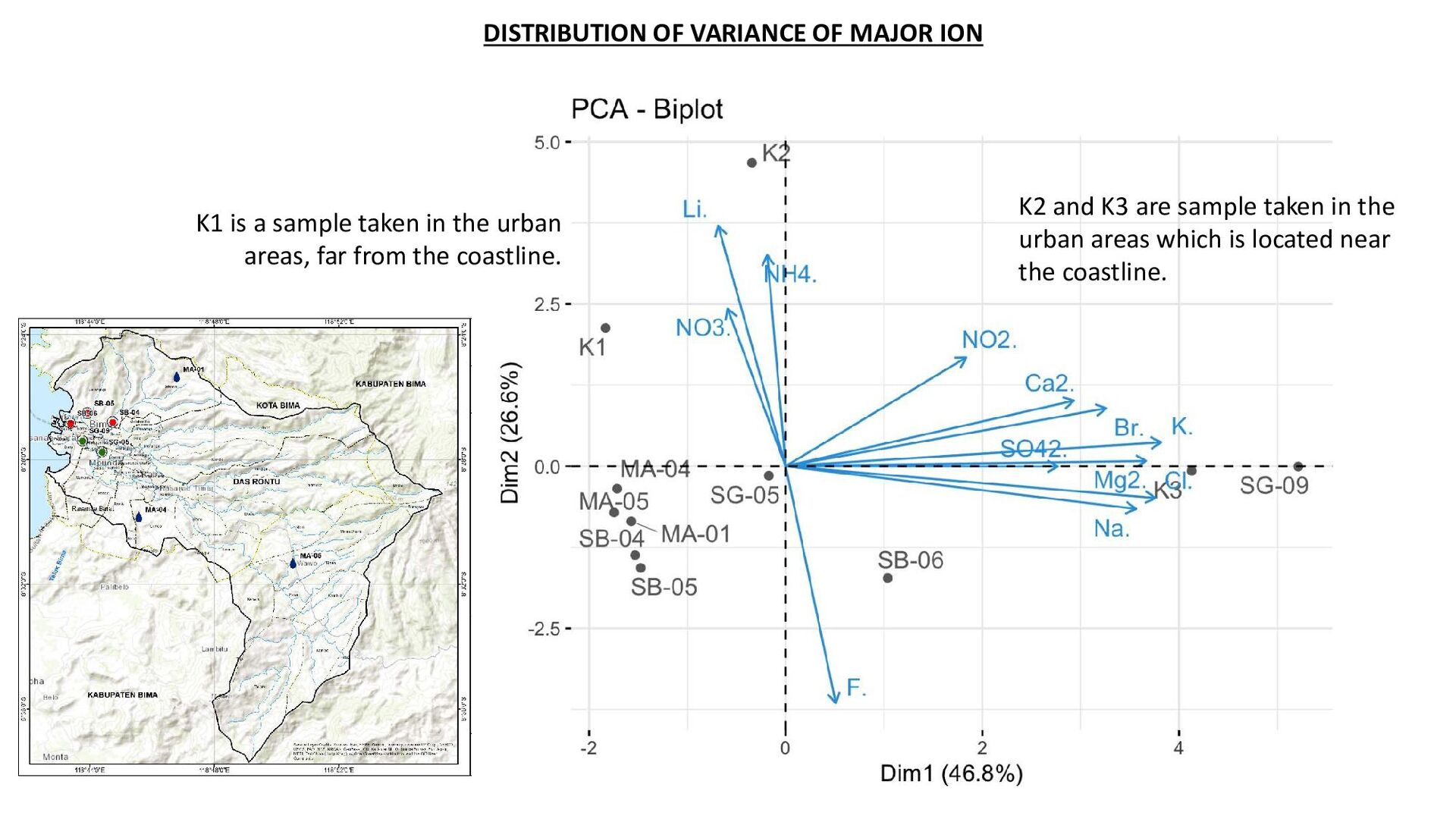
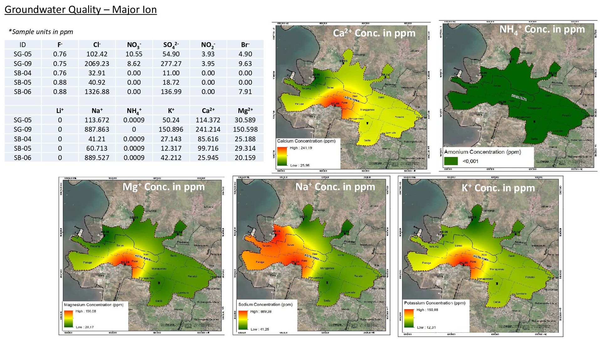
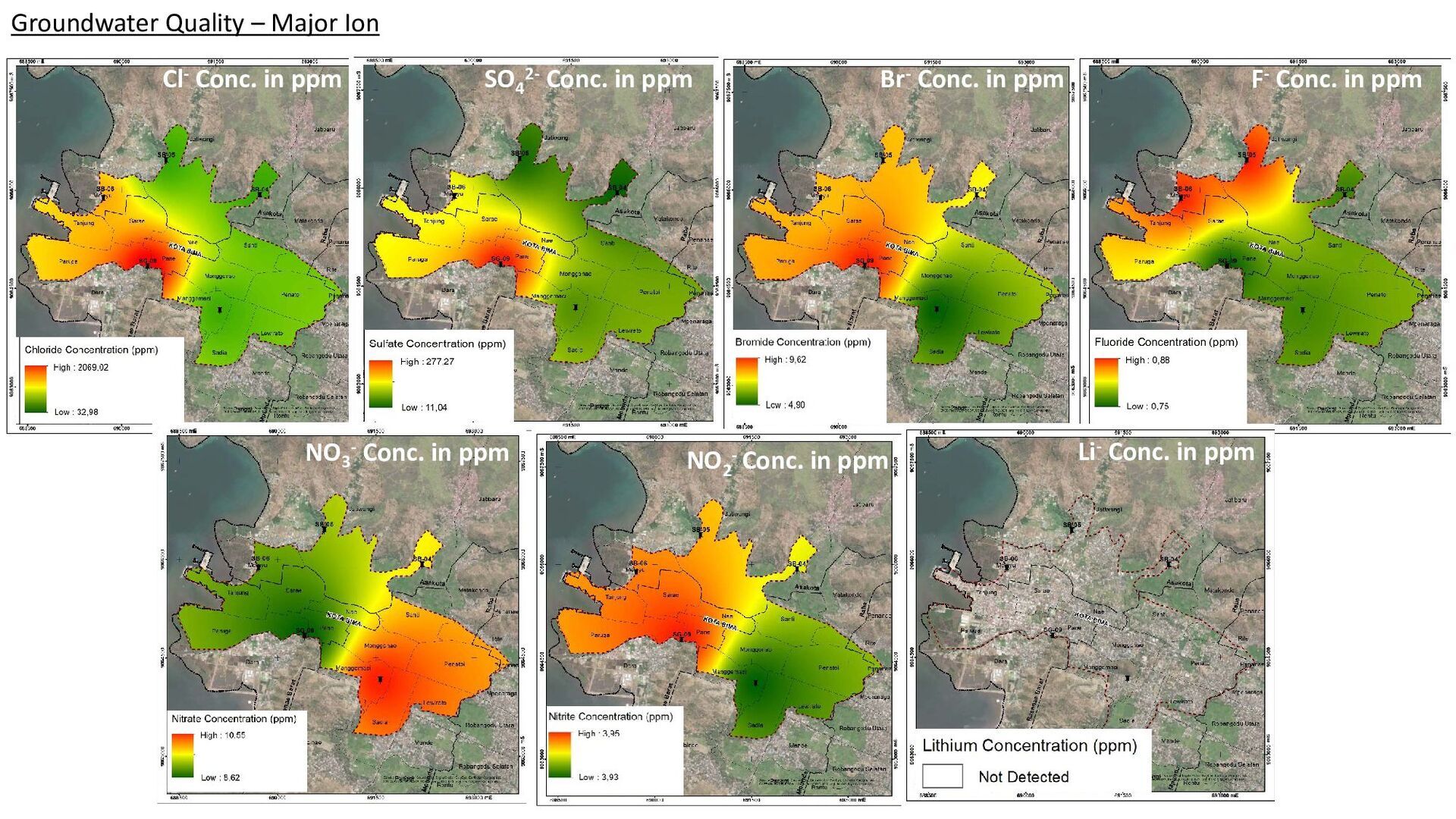
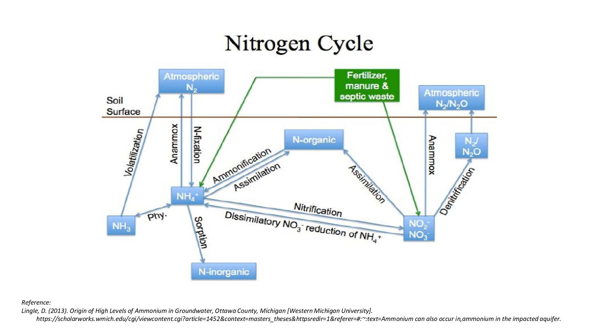
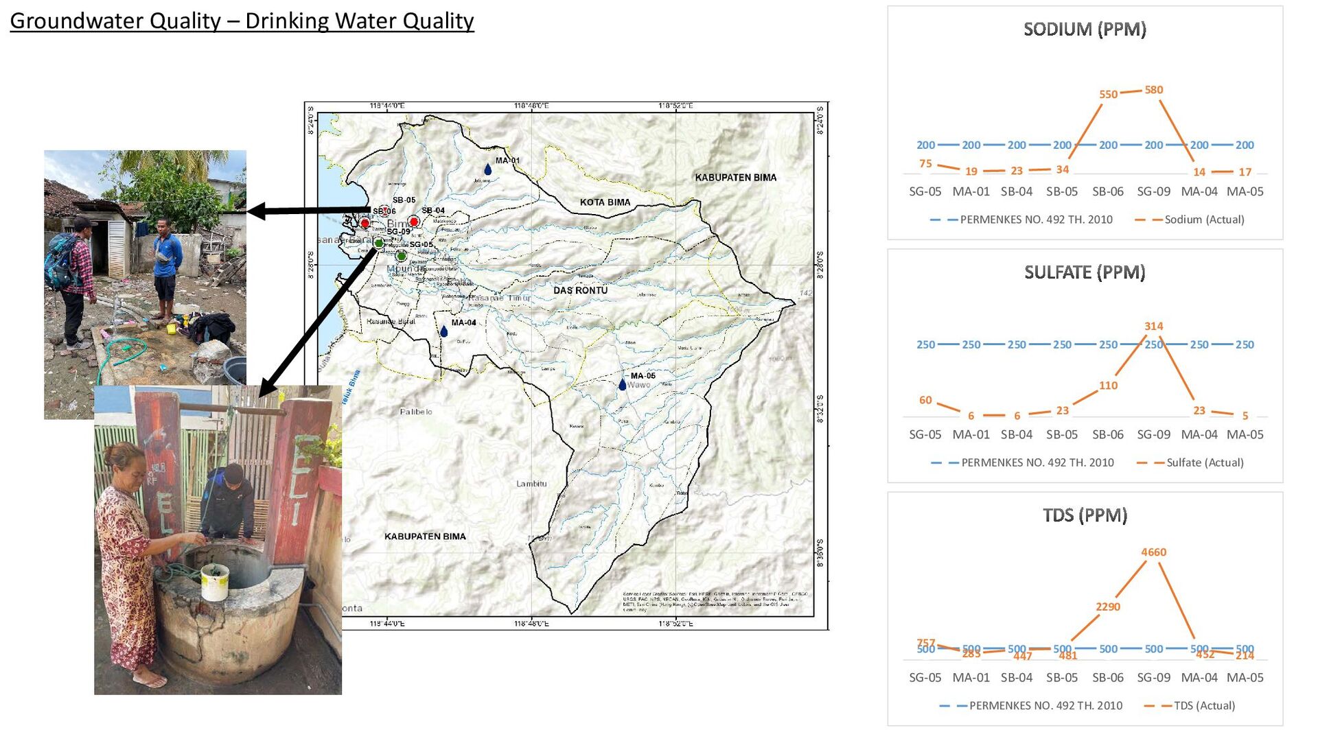
Penelitian potensi sumber daya air Kota Bima, Nusa Tenggara Barat dilakukan dengan batasan daerah penelitian pada DAS (Daerah Aliran Sungai) Rontu. DAS Rontu mencakup batas administrasi Kota Bima dan Kabupaten Bima dengan koordinat 118°42'36"BT s.d 118°55'19,2"BT dan 8°23'49,2"LS s.d. 8°37'40,8"LS, dan elevasi dari 0 MDPL sampai 1.368 MDPL. Penelitian ini mengenai kebutuhan air bersih yang bersumber dari airtanah di kawasan Kota Bima. Beberapa masalah terkait dengan kawasan tersebut di Kota Bima yang dirumuskan dalam RPJMD 2018-2023 diantaranya adalah belum optimalnya penanganan, cakupan pelayanan sampah yang belum optimal, cakupan pelayanan air masih belum optimal, rendahnya kualitas penyelesaian dan keterbatasan cakupan pelayanan air permukaan. Dalam upaya menjangkau cakupan pelayanan air bersih yang lebih optimal, pemanfaatan air permukaan dan air tanah perlu diimplementasikan. Sehingga, pada penelitian ini akan dikaji mengenai potensi sumber daya air tanah di DAS Rontu, serta kualitasnya. Dari pembobotan yang menggunakan metode AHP (Analytical Hierarchy Process) dan inegrasi GIS (Geographic Information System), didapatkan bahwa zona potensi airtanah di DAS Rontu sebagian besar tergolong “Sedang” dengan persentase cakupan 54%, diikuti oleh zona “Tinggi” yang meliputi sekitar 27% dari total luas wilayah studi. Dan zona “Sangat Tinggi” pada 11%, zona “Rendah” hingga “Sangat Rendah” mencakup sekitar 7% dari total luas. Kualitas airtanah ditinjau dari parameter pengukuran in-situ, seperti TDS (Total Dissolved Solids), EC (Electrical Conductivity), temperature, pH, dan DO (Dissolved Oxygen), serta pengukuran kualitas dengan uji laboratorium terhadap 8 titik sampel yang terletak di sekitar kawasan Kota Bima, termasuk dengan sampel mata air, yaitu SB -06, SG-08, SB-05, SB-04, SG-05, MA-01, MA-04, dan MA-05 Pengukuran hidrogeokimia dilakukan untuk mengetahui kandungan ion utama pada setiap sampel menggunakan Ion Chromatography (IC) dan hasil pengukuran diolah dengan R Program serta PCA (Analisis Komponen Utama). Dari pengelompokkan variabel distribusi, diketahui bahwa sebagian besar sampel masuk dalam kategori yaitu jenis kontaminasi yang diakibatkan oleh air payau. Sedangkan, variabel terbesar kedua masuk dalam kategori kontaminasi yang diakibatkan oleh antropogenik. Kategori ketiga merupakan kategori dimana tidak ada dominasi kontaminasi, yang mencakup sampel MA-01, MA-04, MA-05, SB-05 dan SG-05. Jika dilihat dari kelayakan airtanah untuk air minum, hasil menunjukkan bahwa sebagian besar sampel kualitas air minum berada dalam konsentrasi yang diizinkan oleh PERMENKES NO. 492 Tahun 2010. Namun, 2 sampel yaitu SB-06 dan SG-09 memiliki konsentrasi TDS, Sulfat, dan Natrium yang melebihi batas baku mutu, sehingga airtanah dari kedua sumur tersebut tidak dapat dikonsumsi.
Kata kunci: potensi airtanah, AHP, R, PCA, kualitas airtanah, major ion, hidrogeokimia

Lisensi: CC-BY

Dasapta Erwin Irawan

April 22, 2022
Tweet

More Decks by Dasapta Erwin Irawan

Other Decks in Science

Transcript

  1. Groundwater Potential and Quality Assessment in Slums Area, Bima City,

    West Nusa Tenggara, Indonesia PASCALIA VINCA ALVANDO 22719305 Groundwater Engineering Master’s Program, Faculty of Earth Sciences and Technology, Bandung Institute of Technology
  2. BANJIR BANDANG KOTA BIMA 2016 KONDISI SUNGAI KOTA BIMA 2021

    KAWASAN KUMUH (RPJMD KOTA BIMA 2018-2023) Flood Handling Waste Disposal Clean Water Service Housing Quality Kawasan permukiman yang dikatakan kumuh merupakan permukiman yang tidak layak huni karena ketidakteraturan bangunan, tingkat kepadatan bangunan tinggi, dan kualitas bangunan serta sarana dan prasarana yang tidak memenuhi syarat. UU RI No. 1 Tahun 2011 tentang Perumahan dan Kawasan Permukiman There are still limited facilities and infrastructure for flood management, and the drainage system is not well integrated. Community participation in waste management is still low, waste management is not yet integrated, and facilities and infrastructure to manage waste are still lacking. There is no PDAM that is functioning properly. The low income has interlink with the housing quality which still affected by the flood. KONDISI SUNGAI KOTA BIMA 2021 BANJIR BANDANG KOTA BIMA 2016 Background and Research Objectives
  3. Bima City Bima District Spring The spring as the largest

    source of clean water for people in Bima Regency (Wawo Sub-district). The spring is used for bathing/tourism and managed by the Ministry of Tourism. Barren Mountain Conditions Land use change -> increases run off -> flood, low infiltration Groundwater Quality Residents complain about the quality of the well water, which is salty and cannot be consumed. TDS measurement values ​​at the site ranged from 1000 – 4000 ppm. Groundwater Quantity In general, people is highly dependent in groundwater for domestic needs and consumption. RONTU Background and Research Objectives
  4. 7 SPAM = Pump efficiency is low, 2 SPAM =

    Leaks, water loss, fluctuations of discharge in both dry and wet season. PDAM KOTA BIMA Desember 2017 *17.70% 13 SPAM = 11 SPAM 9 SPAM = Water source: GROUNDWATER 2 out of 9 SPAM use surface water as the source of the raw water. *Kecamatan Rasanae Barat, Kecamatan Mpunda, Kecamatan Rasanae Timur, Kecamatan Asakota dan Kecamatan Raba. Background and Research Objectives
  5. Background and Research Objectives 1. Determining the groundwater potential zone,

    2. Assessing the groundwater quality in slums area.
  6. Workflow 200 LITERATURES OF AHP METHOD FOR DETERMINING GROUNDWATER POTENTIAL

    ZONE 6 MAIN LITERATURES *1 LITERATURE *Literature has the similar condition with the study area
  7. Research Method AHP Method - Weighting Pairwise Comparison Matrix Source:

    Saaty TL. The analytic hierarchy process: planning, priority setting and resource allocation. New York: McGraw-Hill; 1980 Source: Ã, R. R., & Ramanathan, U. (2010). A qualitative perspective to deriving weights from pairwise comparison matrices. Omega, 38(3–4), 228–232. https://doi.org/10.1016/j.omega.2009.09.002 CR < 10% means the consistency is acceptable. Source: Saaty TL. The analytic hierarchy process: planning, priority setting and resource allocation. New York: McGraw-Hill; 1980
  8. Research Method AHP Method - Weighting Kumar, V. A., Mondal,

    N. C., & Ahmed, S. (2020). Identification of Groundwater Potential Zones Using RS , GIS and AHP Techniques : A Case Study in a Part of Deccan Volcanic Province ( DVP ), Identification of Groundwater Potential Zones Using RS , GIS and AHP Techniques : A Case Study in a Part of Deccan Volcanic Province ( DVP ), Maharashtra , India. Journal of the Indian Society of Remote Sensing, January. https://doi.org/10.1007/s12524-019-01086-3 Reference Rank 1 – 5 describes the significance of the sub-criteria in determining the groundwater potential zone.
  9. GEOLOGY MAP GEOMORPHOLOGY MAP Thematic Maps 69.37% 16.87% 5.65% 5.85%

    Paneplains Denudational Slopes and Hills 30% 10% 40% 10%
  10. Groundwater Potential Zone Zona Potensi Airtanah • W = (Normalized

    Weight untuk setiap peta tematik) • R = (Rank untuk setiap sub-kategori peta tematik) • i = peta tematik • j = sub-kategori peta tematik Groundwater Potential Zone Map Union by ArcMap
  11. Groundwater Potential Zone Drainage density delineation Wilayah ini tergolong sebagai

    zona potensi airtanah yang “tinggi” akibat nilai kerapatan drainase yang sangat rendah. Slope = 0o - 12o Geology = Alluvium Geomorphology = Flood plain Wilayah ini merupakan zona potensi airtanah “tinggi - sangat tinggi”, yang dihasilkan dari ketiga kriteria di atas. Lineament density delineation Wilayah ini diklasifikasikan sebagai zona potensi airtanah “tinggi - sangat tinggi”, yang merepresentasikan penggambaran kerapatan kelurusan. Drainage density delineation Daerah tersebut dikategorikan sebagai zona potensi airtanah “rendah” akibat kepadatan drainase yang tinggi – sangat tinggi.
  12. Groundwater Quality Total survey points: 65 points Water quality sampling:

    8 points Sampling period: November 2nd - November 8th 2021
  13. DISTRIBUTION OF VARIANCE OF MAJOR ION K1 is a sample

    taken in the urban areas, far from the coastline. K2 and K3 are sample taken in the urban areas which is located near the coastline.
  14. Groundwater Quality – Major Ion Mg+ Conc. in ppm Na+

    Conc. in ppm Ca2+ Conc. in ppm NH4 + Conc. in ppm K+ Conc. in ppm ID F- Cl- NO3 - SO4 2- NO2 - Br- SG-05 0.76 102.42 10.55 54.90 3.93 4.90 SG-09 0.75 2069.23 8.62 277.27 3.95 9.63 SB-04 0.76 32.91 0.00 11.00 0.00 0.00 SB-05 0.88 40.92 0.00 18.72 0.00 0.00 SB-06 0.88 1326.88 0.00 136.99 0.00 7.91 Li+ Na+ NH4 + K+ Ca2+ Mg2+ SG-05 0 113.672 0.0009 50.24 114.372 30.589 SG-09 0 887.863 0 150.896 241.214 150.598 SB-04 0 41.21 0.0009 27.143 85.616 25.188 SB-05 0 60.713 0.0009 12.317 99.716 29.314 SB-06 0 889.527 0.0009 42.212 25.945 20.159 *Sample units in ppm
  15. Groundwater Quality – Major Ion Cl- Conc. in ppm SO4

    2- Conc. in ppm Br- Conc. in ppm F- Conc. in ppm Li- Conc. in ppm NO2 - Conc. in ppm NO3 - Conc. in ppm
  16. Reference: Lingle, D. (2013). Origin of High Levels of Ammonium

    in Groundwater, Ottawa County, Michigan [Western Michigan University]. https://scholarworks.wmich.edu/cgi/viewcontent.cgi?article=1452&context=masters_theses&httpsredir=1&referer=#:~:text=Ammonium can also occur in,ammonium in the impacted aquifer.
  17. 500 500 500 500 500 500 500 500 757 285

    447 481 2290 4660 452 214 SG-05 MA-01 SB-04 SB-05 SB-06 SG-09 MA-04 MA-05 PERMENKES NO. 492 TH. 2010 TDS (Actual) 200 200 200 200 200 200 200 200 75 19 23 34 550 580 14 17 SG-05 MA-01 SB-04 SB-05 SB-06 SG-09 MA-04 MA-05 PERMENKES NO. 492 TH. 2010 Sodium (Actual) 250 250 250 250 250 250 250 250 60 6 6 23 110 314 23 5 SG-05 MA-01 SB-04 SB-05 SB-06 SG-09 MA-04 MA-05 PERMENKES NO. 492 TH. 2010 Sulfate (Actual) Groundwater Quality – Drinking Water Quality
  18. Conclusions and Recommendation 1. The groundwater potential zone in Rontu

    Watershed is mainly classified as “Medium” with percentage coverage of 54%, followed by zone “High” which is covering for about 27% of the total study area. And zone “Very High” in 11%, zone “Low” to “Very Low” covers about 7% of the total area. 2. Most samples for drinking water quality are within the permitted concentration by PERMENKES NO. 492 Tahun 2010. However, 2 samples which are the SB-06 and SG-09 have high concentration of TDS, Sulfate, and Sodium, therefore groundwater from the two wells are not potable.