Upgrade to Pro — share decks privately, control downloads, hide ads and more …

20260318UNOpenGISInitiative(UNVT)-Koji Osumi

20260318UNOpenGISInitiative(UNVT)-Koji Osumi

Avatar for Koji Osumi

Koji Osumi

March 13, 2026

More Decks by Koji Osumi

Other Decks in Programming

Transcript

  1. Vector Tile Deployment with the United Nations Vector Tile Toolkit

    (UNVT) Koji OSUMI UN Open GIS Monthly VTC Wednesday, 18 March 2026 Geospatial Information Section, OICT
  2. Agenda • What is UNVT? • Overview of Our Work

    (Production, Styling, Hosting) • Strength of UNVT • Current Activities • Summary
  3. What is UNVT? • UNVT is a collection of Open

    Source Software (OSS) to produce, host, style, optimize and use vector tiles for web mapping. It also shares technical know-how. • UNVT is an effort under the UN Open GIS Initiative, and was initiated by Mr. Fujimura in 2018. • UNVT was developed by Mr. Ubukawa to enable the automatic and continuous updating of basemap vector tiles for UN operations. Combining Efforts with UN. Founder of UNVT. Mr. Fujimura Developed by Mr. Ubukawa (2019-2023)
  4. Overview of Our Work • UN Global Service Centre(UNGSC) provides

    map service to UN missions. • We have worked together to deploy vector tiles with open-source method at UNGSC. OSM source UN source Supported by UNVT, open source scripts Produce Host Style Optimize Import UNVT workflow for developing vector tile for basemap Source DB (PostGIS) Users • UN GeoPortal • Web APP • Etc. Host tiles/maps Define map Style Produce tile
  5. Overview of Our Work: Production Flexible Conversion Settings By choosing

    the optimal combination of features, attributes, and zoom levels, we can reduce the data size. à This allows maps to load and display faster Motorway Converting the data with zoom levels: 4 - 15 Small road Converting the data with zoom levels: 12 - 15
  6. Overview of Our Work: Production Automatic Update Daily (or weekly)

    as a scheduled task à UN Mappers’ contributions are reflected quickly OSM(12th Feb) UNVT(14th Feb) Added data OSM source UN source Mapping work is reflected quickly Daily Update
  7. Overview of Our Work: Styling Efficient Styling Tool: unvt/charites YAML

    files (easy to edit) Style files (Maplibre/Arcgis) •JSON format - Single file - Many lines (thousands) - Difficult to read/edit •YAML format - Multiple files per layer - Fewer lines - Human readable JSON
  8. Overview of Our Work: Styling Efficient Styling Tool: unvt/charites YAML

    file updates are automatically reflected on the map fill-color: "#D8EBF5" fill-color: : "#90daee"
  9. Overview of Our Work: Hosting Contour Line + Hillshade Building

    3D Standard Contour Line + Hillshade + 3D Terrain Available with MapLibre GL JS Easy to switch the maps
  10. Overview of Our Work 3D Web Map 2D Web Map

    2D Web Map Tiles Styles Libraries APPs Style (2D) Library MapLibre GL JS Vector Tile OSM and UN Vector Tile Contour Raster Tile Elevation MapLibre Plugin UN GeoPortal Library MapLibre GL JS Style (3D) MapLibre Plugin Style (for Esri) 30 GB (-ZL13) 179 GB (-ZL12) 162 GB (-ZL15) System Overview
  11. Strength of UNVT • Efficient Styling Tool unvt/charites Production Styling

    Hosting Technology-Agnostic, High Performance • Flexible conversion settings Select optimal features, attributes, and zoom levels to reduce data size • Automatic update Daily (or weekly) update as scheduled task.(no manual effort) • Authentication allows only UN staff to access the maps • Seamless 3D rendering Easy to switch the maps
  12. Current Activities Adjusted the style to align with new UN

    Street Map Using unvt/charites Well Contrasted Color Scheme!
  13. Current Activities Developed ArcGIS Pro Interface 1. Tile Map Tile

    map tells the renderer where tiles exist and help to avoid unnecessary requests. UNVT Hosting Server 1. Tile request with a token ArcGIS Pro UN GeoPortal 2. Validation request for the token 3. Response with OK or Error 4. Sending the tile data if OK 2. Token Validation Process ArcGIS Pro specification difference UN GeoPortal
  14. Current Activities Reducing Vector Tile Size to Improve Performance :

    Method Issue: UNVT map load speed is not fast at some zoom levels Method: Reduced the number of vertices to make the vector tiles smaller Each dot represents a vertex. The simplified polygon on the right has fewer vertices but maintains the same visual shape. OSM source UN source Source DB (PostGIS) Vector tiles Data Simplification (PostGIS + Tippecanoe) Geometry Simplification
  15. Current Activities Reducing Vector Tile Size to Improve Performance :

    Example Simplification Level Original Oversimplified Simplified, but visually same to the original ✔ OK ✖ Not OK
  16. Current Activities Reducing Vector Tile Size to Improve Performance :

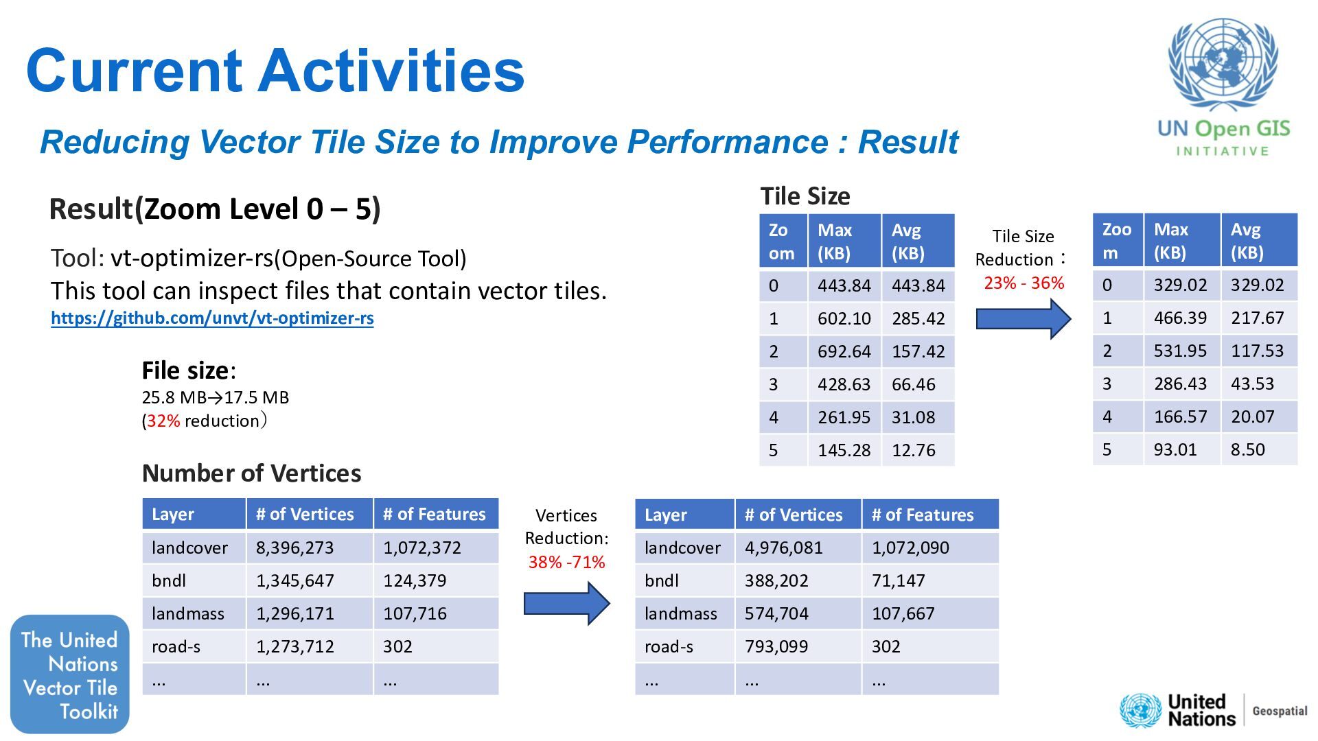
    Result Result(Zoom Level 0 – 5) Zoo m Max (KB) Avg (KB) 0 329.02 329.02 1 466.39 217.67 2 531.95 117.53 3 286.43 43.53 4 166.57 20.07 5 93.01 8.50 Zo om Max (KB) Avg (KB) 0 443.84 443.84 1 602.10 285.42 2 692.64 157.42 3 428.63 66.46 4 261.95 31.08 5 145.28 12.76 Tile Size Reduction: 23% - 36% Tool: vt-optimizer-rs(Open-Source Tool) This tool can inspect files that contain vector tiles. https://github.com/unvt/vt-optimizer-rs File size: 25.8 MB→17.5 MB (32% reduction) Tile Size Layer # of Vertices # of Features landcover 8,396,273 1,072,372 bndl 1,345,647 124,379 landmass 1,296,171 107,716 road-s 1,273,712 302 ... ... ... Layer # of Vertices # of Features landcover 4,976,081 1,072,090 bndl 388,202 71,147 landmass 574,704 107,667 road-s 793,099 302 ... ... ... Vertices Reduction: 38% -71% Number of Vertices
  17. Summary and Way Forward Join us at https://github.com/unvt UN Vector

    Tile Toolkit is a collection of Open Source Software (OSS) for web mapping, developed under the UN Open GIS Initiative. UN Vector Tile Toolkit has been deployed in the UN Basemap system to provide regularly updated web maps. Working with our partners, we will continue improving our maps to support UN operations. Image Credits: • Map – United Nations Geospatial, UN Peacekeeping and Political Missions, UN Global Service Centre, © OpenStreetMap contributors • Icons – Esri and the Esri Logo are licensed trademarks of Environmental Systems Research Institute, Inc.