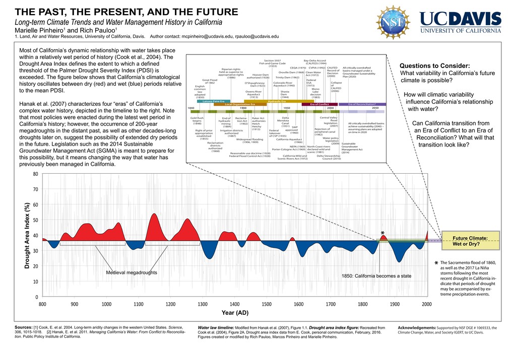
900 1000 1100 1200 1300 1400 1500 1600 1700 1800 1900 2000 Drought Area Index (%) Year (AD) Most of California’s dynamic relationship with water takes place within a relatively wet period of history (Cook et al., 2004). The Drought Area Index defines the extent to which a defined threshold of the Palmer Drought Severity Index (PDSI) is exceeded. The figure below shows that California’s climatological history oscillates between dry (red) and wet (blue) periods relative to the mean PDSI. Hanak et al. (2007) characterizes four “eras” of California’s complex water history, depicted in the timeline to the right. Note that most policies were enacted during the latest wet period in California’s history; however, the occurrence of 200-year megadroughts in the distant past, as well as other decades-long droughts later on, suggest the possibility of extended dry periods in the future. Legislation such as the 2014 Sustainable Groundwater Management Act (SGMA) is meant to prepare for this possibility, but it means changing the way that water has previously been managed in California. 1850: California becomes a state Medieval megadroughts Sources: [1] Cook, E. et al. 2004. Long-term aridity changes in the western United States. Science, 306, 1015-1018. [2] Hanak, E. et al. 2011. Managing California’s Water: From Conflict to Reconcilia- tion. Public Policy Institute of California. THE PAST, THE PRESENT, AND THE FUTURE Long-term Climate Trends and Water Management History in California Marielle Pinheiro1 and Rich Pauloo1 1. Land, Air and Water Resources, University of California, Davis. Author contact:
[email protected],
[email protected] English common law adopted (1850) Gold Rush begins (1848) SWP approved (1960) Water policy legislation (2009) Right of prior appropriation established (1855) Reclamation districts authorized (1868) Widespread flooding (1906, 1909) Reasonable use doctrine (1928) Federal Flood Control Act (1928) NEPA (1969) Porter-Cologne Act (1969) California Wild and Scenic Rivers Act (1972) Delta Stewardship Council (2010) California Aqueduct (1966) North Coast rivers declared wild and scenic (1981) Irrigation districts authorized (1887) Federal takeover of CVP (1935) End of hydraulic mining (1884) Delta Mendota Canal (1951) Central Valley flood legislation (2007) Reclama- tion Act (1902) Raker Act authorizes Hetch Hetchy (1913) Rejection of peripheral canal (1982) Riparian rights held as superior to appropriative rights (1886) Section 5937 Fish and Game Code (1933) Bay-Delta Accord (CALFED) (1994) CALFED Record of Decision (2000) Collapse of CALFED (2006) O’Shaughnessy Dam (1923) Colorado River Aqueduct (1940) Hoover Dam authorized (1928) Trinity Dam (1962) Oroville Dam (1968) Clean Water Act (1972) Federal ESA (1973) CEQA (1970) CVPIA (1992) Owens River Aqueduct (1913) Shasta Dam (1944) Mono Lake decision (1983) Great Flood of 1862 1840 0 0 9 1 0 0 9 1 1950 2000 Laissez-Faire Era Hydraulic Era Local Organization Era Era of Conflict Sustainable Groundwater Management Act (2014) All critically overdrafted basins managed under a Groundwater Sustainability Plan (2020) All critically overdrafted basins achieve sustainability (2040) -- assuming plans are adopted on time in 2020 2050 Era of Reconciliation? Future Climate: Wet or Dry? Questions to Consider: What variability in California’s future climate is possible? How will climatic variability influence California’s relationship with water? Can California transition from an Era of Conflict to an Era of Reconciliation? What will that transition look like? Water law timeline: Modified from Hanak et al. (2007), Figure 1.1. Drought area index figure: Recreated from Cook et al. (2004), Figure 2A. Drought area index data from E. Cook, personal communication, February, 2016. Figures created or modified by Rich Pauloo, Marcos Pinheiro and Marielle Pinheiro. Acknowledgements: Supported by NSF DGE # 1069333, the Climate Change, Water, and Society IGERT, to UC Davis. * * The Sacramento ood of 1860, as well as the 2017 La Niña storms following the most recent drought in California in- dicate that periods of drought may be accompanied by ex- treme precipitation events.