Upgrade to Pro — share decks privately, control downloads, hide ads and more …

Dynamic Mapping of Secondary Cities: A Global and Innovation Context

SecondaryCities
June 15, 2016
610

Dynamic Mapping of Secondary Cities: A Global and Innovation Context

SecondaryCities

June 15, 2016
Tweet

More Decks by SecondaryCities

Transcript

  1. Dynamic Mapping of Secondary Cities: - A Global and Innovation

    Context Chaowei Phil Yang, Ph.D. Director, NSF Spatiotemporal Innovation Center Professor of GIScience, George Mason Univ.
  2. 2 1.Problems are global distributed 2.Big spatiotemporal data 3.Global dynamics

    of sharing and accessing to data 4.Complex and interdisciplinary
  3. 4 Physical Infrastructure and Network Configuration InfiniBand (2x12x20Gbps) Ethernet (1Gbps)

    Ethernet (1Gbps) 84 84 84 84 84 84 IBM dx360 Intel Xeon CPU X5660 @2.8Ghz x 24 24GB RAM Total: 504 servers GMU Network & Internet Gateway Server InfiniBand (20Gbps) x 2 InfiniBand (20Gbps ) x 2 InfiniBand Switches InfiniBand Switches OS: Ubuntu 14.04 x 252 CentOS 6.6 x 252 10Gbps 1Gbps Gateway Server
  4. 8 Spatiotemporal B-Tree Index Bridge the gap between the logical

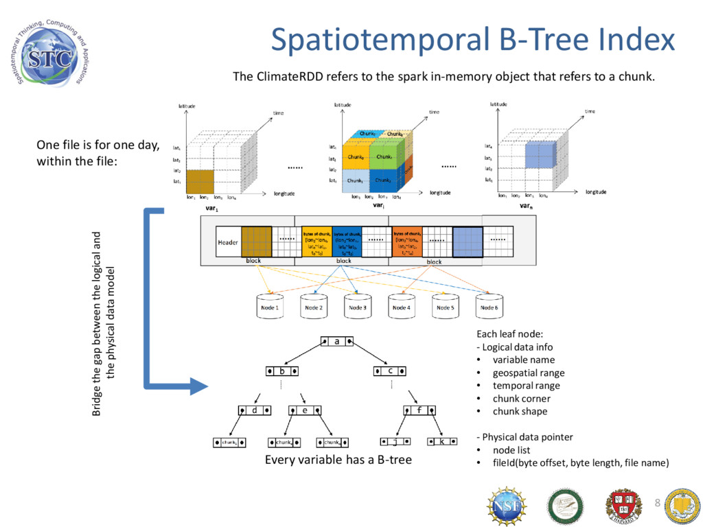
    and the physical data model Each leaf node: - Logical data info • variable name • geospatial range • temporal range • chunk corner • chunk shape - Physical data pointer • node list • fileId(byte offset, byte length, file name) One file is for one day, within the file: Every variable has a B-tree The ClimateRDD refers to the spark in-memory object that refers to a chunk.
  5. Existing Sub-Saharan Arid and Semi-arid Sub-meter Commercial Imagery 9600 Strips

    (~80TB) being delivered to GSFC in ADAPT ~1600 strips (~20TB) at GSFC in ADAPT Area Of Interest (AOI) for Sub-Saharan Arid and Semi-arid Africa From Dan Duffy
  6. 11 Dust Storm Hazards Desertification Illness & Diseases Traffic &

    Car accidences Air Pollution Ecological System Global/regional Climate Phoenix Dust Storm a "100-Year Event“, 2011, July 5th
  7. 12 We can : Setup simulation through web interface, &

    See results in real scientific means on demand 8/12/2016 12 Dust Storm eScience Infrastructure
  8. 13 I/UCRC for Spatiotemporal Thinking, Computing, and Application is Formed

    by • UCSB Center for Spatial Studies (as a continuation of NCGIA) leads GIScience innovation -> Spatiotemporal Thinking • GMU Center for Intelligent Spatial Computing leads computational research for geospatial issues -> Spatiotemporal Computing • Harvard Center for Geographic Analyses supports applications of world significance
  9. 16 Goal & Objectives Advance • Spatiotemporal thinking -> Human

    intelligence • Spatiotemporal computing -> Computer software and tools • Spatiotemporal applications -> Human capability of responding to deep scientific questions and grand engineering challenges Collaboratively, make a difference by building the spatiotemporal infrastructure. • Innovative Research–Academia • Products and Services–Industry • Operations–Agencies 16
  10. Smart City Smart City Smart Transportation Smart Health Smart education

    and science Smart public utilities Smart citizen service Smart Public Safety Comprehensive sensing full integration Innovation Sustainable operation •Automatic charge •Ticketing management •Transportation management •Etc. •medical records •Health services •Personalized Treatment •Etc. •Crime information •Emergency response •Real-time monitoring •Etc. •High-speed Network •Smart power •Energy smart •Smart Water •Etc. •Open learning •Advanced classroom •Wisdom park •Etc. •Insurance management •Employee service •Family services •Housing information management IBM & N. Chen
  11. Whatever you’re doing Wherever you are Whatever you’re using In

    the Air On the Road In Town Managed Office At Your Desk At Home Cellular Blackberry PDA PC ERP Telephony Collaboration E-mail Internet of Things for Smart Service N. Chen
  12. 20 Supporting Secondary City Dynamic Mapping with Spatiotemporal Innovations Data

    Infrastructure Sustainable Smart Thinking Computing Applications Innovation