Upgrade to Pro — share decks privately, control downloads, hide ads and more …

Citizen Participation and GIS Use in Urban India

Citizen Participation and GIS Use in Urban India

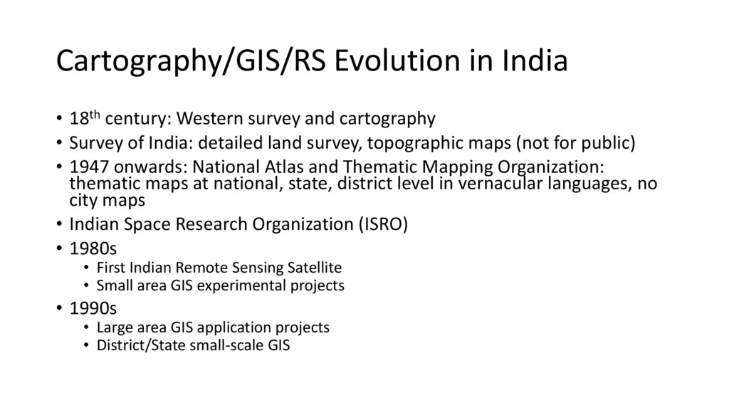
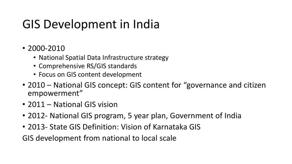
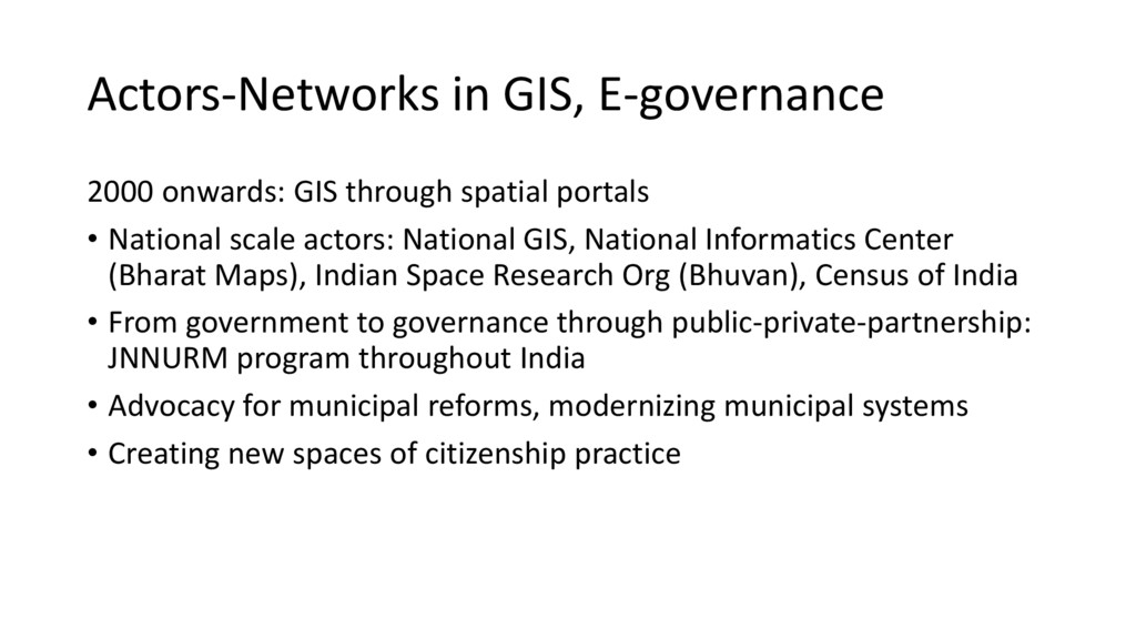
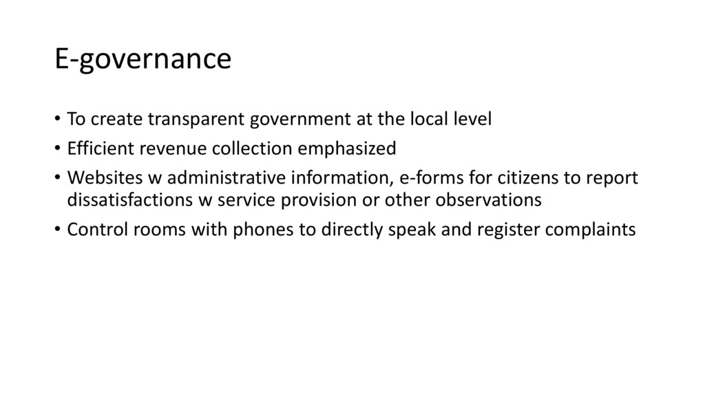
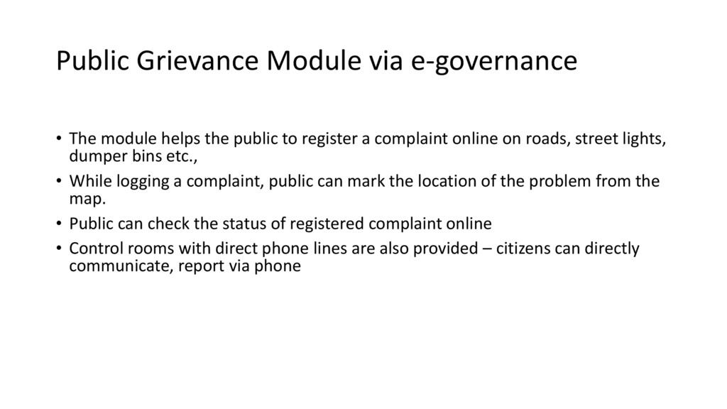
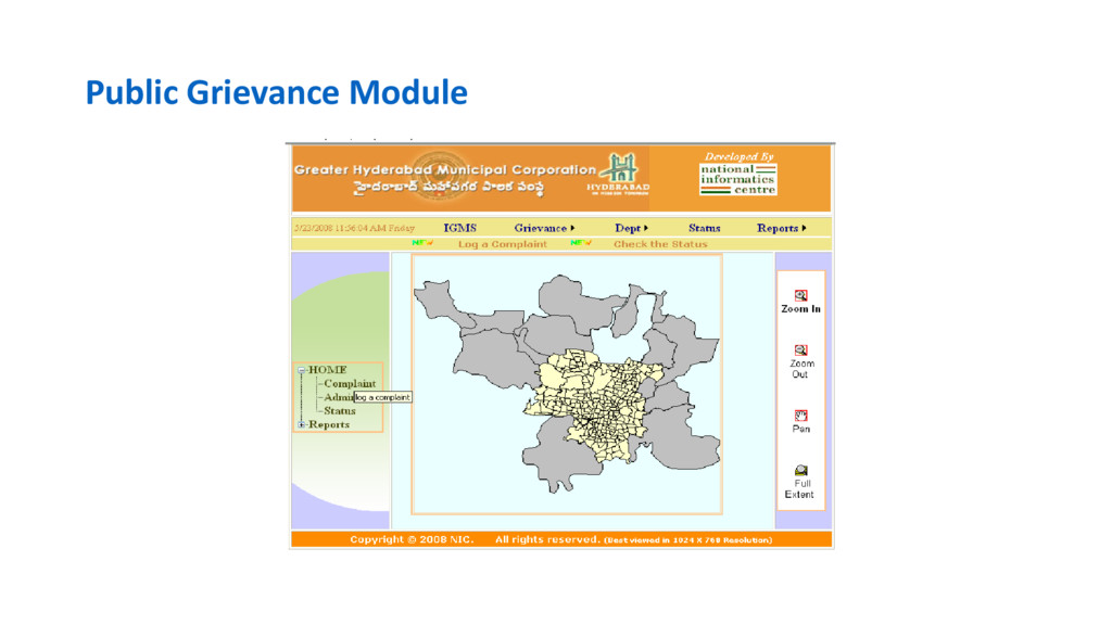
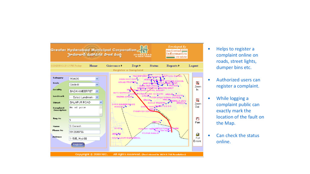
While the global North has a long history of utilizing GIS for spatial decision making, its usage in India has been relatively recent. Further, the concept of citizen participation in planning activities is relatively new in India, and its effectiveness is shaped by multiple contextual factors. Because of the recent emphasis on collaborative governance and transparency, GIS is used to enhance citizen participation through e-governance projects and through Public Participation GIS. This paper aims to examine the complexities of embedded in citizen participation through GIS based knowledge production in urban communities in India. Through empirical findings, it aims to demonstrate how cultural, political and technological factors differentially shape the ways GIS is being used in enhancing citizen participation in urban planning in India.

SecondaryCities

June 15, 2016
Tweet

More Decks by SecondaryCities

Other Decks in Technology

Transcript

  1. Citizen Participation and GIS Use in Urban India Dr. Rina

    Ghose Professor, Department of Geography University of Wisconsin-Milwaukee [email protected]
  2. Goals • Citizenship rights in India • New spaces of

    citizenship practice through e-governance and GIS • Spatial knowledge production, outcomes
  3. Exercising citizenship in India: Issues • High levels of inequalities

    in exercising citizenship rights to essential goods and services • Little accountability from state agencies, powerful political elites • Lack of vertical accountability: citizens unable to hold state agencies, political leaders accountable • Weak horizontal accountability: bureaucracies/political elites manipulate the system through patronage, corruption, stifling dissent
  4. Public participation and GIS • 74th Amendment of constitution: new

    opportunities for participation • Right to Information Act (RTI) • New governance model with use of ICT • e-governance, GIS mapping and use, invited spaces of public participation • Municipal reform and modernization – streamline service delivery
  5. Cartography/GIS/RS Evolution in India • 18th century: Western survey and

    cartography • Survey of India: detailed land survey, topographic maps (not for public) • 1947 onwards: National Atlas and Thematic Mapping Organization: thematic maps at national, state, district level in vernacular languages, no city maps • Indian Space Research Organization (ISRO) • 1980s • First Indian Remote Sensing Satellite • Small area GIS experimental projects • 1990s • Large area GIS application projects • District/State small-scale GIS
  6. GIS Development in India • 2000-2010 • National Spatial Data

    Infrastructure strategy • Comprehensive RS/GIS standards • Focus on GIS content development • 2010 – National GIS concept: GIS content for “governance and citizen empowerment” • 2011 – National GIS vision • 2012- National GIS program, 5 year plan, Government of India • 2013- State GIS Definition: Vision of Karnataka GIS GIS development from national to local scale
  7. Actors-Networks in GIS, E-governance 2000 onwards: GIS through spatial portals

    • National scale actors: National GIS, National Informatics Center (Bharat Maps), Indian Space Research Org (Bhuvan), Census of India • From government to governance through public-private-partnership: JNNURM program throughout India • Advocacy for municipal reforms, modernizing municipal systems • Creating new spaces of citizenship practice
  8. National GIS Goals • A National GIS platform with “GIS-centric

    computing and networking infrastructure” • “Seamless, nationwide National GIS asset at 1:10,000 scale, as well as city-level data at larger scales” • “Focused GIS capacity-building initiatives” • “Pragmatic geographic information (GI) policy positioning and best practices for National GIS”
  9. Bharat Maps (NIC) • A Multi-layer GIS Platform “to establish

    end to end geo-spatial electronics delivery systems as part of Mission Mode Projects in e- Governance domain” • Integrated base map service using 1:50,000 scale reference data from Survey of India, ISRO, FSI, RGI … • 23 data layers containing administrative boundaries, transport layers such as roads & railways, forest layer, settlement locations etc., including terrain map services.
  10. JAWAHAR LAL NEHRU NATIONAL URBAN RENEWAL MISSION(JNNURM) • A scheme

    for sustainable urban reforms & urban governance • Focus on strengthening of Municipal Governments functioning according to the 74th Constitutional Amendment
  11. National Urban Information System (Source: NIC) National Mission launched in

    March, 2006 to meet two major requirements, namely (a) Urban Spatial Information System (USIS), and (b) National Urban Data Bank & Indicators (NUDB&I) as Town Level Database NUIS , a comprehensive Information System for Urban Local Bodies for Planning, Management & Decentralized Governance to implement the objectives of 74th Constitution Amendment Act Coverage – 153 Towns
  12. National Architecture (NA) of enabling E-governance in ULBs envisages “Information

    and Service Need Assessment (ISNA) study” for 4041 ULBs across the country and support of Geo-Spatial Technologies for location specific planning & decision making.  “GIS based System for Urban Local Bodies” using National GIS Framework already established by NIC. Map 5000+ urban centers, from the ward level to the city level. Incorporate city statistics and other data.  National Portal for ULBs - A web based portal integrating MIS of multiple urban initiatives with GIS based maps as single window information for ULBs. National Urban Information Systems
  13. 4041 ULBs as per Census 2011 “The exact locations of

    the towns in terms of longitudes and latitudes are not available. So the locations of the towns is to be digitized from the Survey of India topographic maps of 1:50,000 scale. The towns are generally shown in the map as group of polygons spread closely to each other. The locations are taken approximately in the middle of the group of polygons to represent the concerned towns in the digital data. These locations are coded with both 2001 and 2011 Census codes.”
  14. E-governance • To create transparent government at the local level

    • Efficient revenue collection emphasized • Websites w administrative information, e-forms for citizens to report dissatisfactions w service provision or other observations • Control rooms with phones to directly speak and register complaints
  15. Hyderabad: Property-tax Module •To enhance the collection of property-tax. •Identify

    assessed and non- assessed properties on the map. •Property details can be viewed. •Actual and calculated plinth-area can be viewed and verified for better tax collection. •GHMC can isolate the plinth areas for un-assessed properties to improve the collection of Property tax.
  16. Limitations • Heavily used by administrators, facilitates tax collection •

    Less used by citizens – Digital divide? Unused to maps? • Interface in English, local language not used – excludes non-English speakers • Websites not well publicized, many unaware • Users primarily well educated, middle class • Website maintenance can be inconsistent • Control rooms popular due to direct contact, eliminates long lines in offices
  17. Public Grievance Module via e-governance • The module helps the

    public to register a complaint online on roads, street lights, dumper bins etc., • While logging a complaint, public can mark the location of the problem from the map. • Public can check the status of registered complaint online • Control rooms with direct phone lines are also provided – citizens can directly communicate, report via phone
  18. • Helps to register a complaint online on roads, street

    lights, dumper bins etc. • Authorized users can register a complaint. • While logging a complaint public can exactly mark the location of the fault on the Map. • Can check the status online.
  19. Citizen Participation in Governance Model • Low use of e-based

    public grievance module, greater use of control rooms • Improvement in service delivery: ‘petty complaints’ (type A) treated more efficiently, eliminates wastage of time, long lines at offices • Problems requiring resource investment (types B, C) less addressed • Grievance redressal systems highly individualized, users mainly educated, familiar w navigating administration • Slum residents present grievances as a community to ward leader, local MLA, local NGO (as individuals socially marginalized)
  20. Citizen Participation, Governance • Lack of government accountability a major

    problem, power positions strongly entrenched • No actions against government workers who refuse service to citizens • E-governance, GIS use facilitates internal administration, used by government employees
  21. Spatial knowledge, Activism, Citizen Participation • Nationwide availability of city

    scale maps, images available to public for the first time through Bhuvan, Bharat Maps etc. • Surge in research re urban growth and change, poverty and deprivation, urban environmental monitoring, disaster mapping etc • New spaces of citizen participation: Map based activism, many PPGIS studies in Indian cities • Contesting social and environmental injustice in new ways • Hand drawn to digital: Arc View, Google Maps • Free and open source software (QGIS, CartoDB, OSM…)
  22. Transparent Chennai • Non profit action research think tank •

    Interactive mapping system using Google Maps w thematic layers • Improve government accountability, empower residents to take action • “Transparent Chennai aggregates, creates and disseminates data and research about important civic issues facing Chennai.. Our goal is to enable residents, especially the poor, to have a greater voice in planning and city governance.” • Citizens encouraged to add information • Popular among NGOs, activists, middle class civil society
  23. Humara Bachpan • Kids in India Are Sparking Urban Planning

    Changes by Mapping Slums • As part of a civic campaign centered on "child clubs," groups of children are creating detailed "social maps" of their marginalized neighborhoods to voice their concerns about public space • Advocacy through mapping
  24. • “Teams of young mappers and adult facilitators spend roughly

    45 days traversing their slums. They learn the shape of their neighborhood, how streets interconnect (or don't), and the density of homes there. This information becomes the map's skeleton. Then, they fill in the specifics. They stake out what's needed through the eyes of children—where underserved public areas could become play spaces, where trash bins could be added in an area they regularly see littered with filth. Their ideal neighborhood is drawn and detailed onto the map. Then, after it's complete, leaders from the child clubs present their work to local officials.”
  25. PPGIS in New Delhi Hoyt, Khosla, Canepa, JUT, 2005 •

    A. Context and Problem • 1. Rapid urban growth/increased demand for basic services • 2. Many legal, illegal squatter settlements • 3. Local agencies lack information re squatter settlements (sp. Illegal) • 4. Delhi Jal Board (DJB) required to provide water to all low-income settlements
  26. • B. Intervention – National Institute for Urban Affairs, stakeholders,

    community • 1. Build community capacity and increase government responsiveness • 2. New Sanjay Amar Colony is an informal settlement in eastern New Delhi • 3. Planning, Learning, and Action (PLA) techniques • 4. Community mapping exercises : Chalk used to draw a map of the community directly on the ground, sticks, leaves and pebbles to represent demographic information in the square of the map
  27. • C. Impact • Using Information to Leverage Improved Public

    Services • i. Insufficient number of water taps • ii. A preponderance of broken water taps • iii. Insufficient water delivery and drainage systems • iv. Unequal access to water taps
  28. • 2. Actions • i. Residents showed DJB engineers the

    location of existing taps, broken taps, low water pressure points, other concerns • ii. A construction crew broke ground to lay new pipelines, repair and install new stand posts • Iii. More water taps installed • Project led by women