Upgrade to Pro — share decks privately, control downloads, hide ads and more …

State of GeoServer - FOSS4G 2022 Edition

State of GeoServer - FOSS4G 2022 Edition

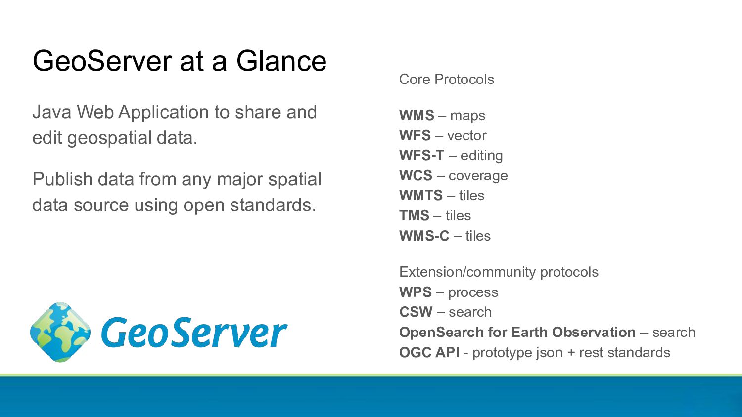
GeoServer is a web service for publishing your geospatial data using industry standards for vector, raster and mapping, as well as to process data, either in batch or on the fly.
GeoServer powers a number of open source projects like GeoNode and geOrchestra and it is widely used throughout the world by organizations to manage, disseminate and analyze data at scale.

This presentation provides an update on our community as well as reviews of the new and noteworthy features for the latest releases. In particular, we will showcase new features landed in 2.20 and 2.21, as well as a preview of what we have in store for 2.22 (to be released in September 2022).

Attend this talk for a cheerful update on what is happening with this popular OSGeo project, whether you are an expert user, a developer, or simply curious what GeoServer can do for you.

Simone Giannecchini

August 31, 2022
Tweet

More Decks by Simone Giannecchini

Other Decks in Technology

Transcript

  1. Jody Garnett [email protected] @jodygarnett GeoCat Government Geographic Data publishing Andrea

    Aime Technical Lead [email protected] @geowolf GeoSolutions Innovative, robust, cost-effective solutions leveraging best-of-breed Open Source products. This presentation is brought to you by
  2. GeoServer at a Glance Java Web Application to share and

    edit geospatial data. Publish data from any major spatial data source using open standards. Core Protocols WMS – maps WFS – vector WFS-T – editing WCS – coverage WMTS – tiles TMS – tiles WMS-C – tiles Extension/community protocols WPS – process CSW – search OpenSearch for Earth Observation – search OGC API - prototype json + rest standards
  3. Core committers are nominated by their peers and trusted with

    the ability to approve pull-requests. We also support community commit access by request (often to work on a specific research and development topic): • 21 committers Project Steering Committee serves to guide the project drawing from the various groups with a stake in the success of the project. • Alessio Fabiani • Andrea Aime • Ian Turton • Jody Garnett • Jukka Rahkonen • Kevin Smith • Nuno Oliveira • Simone Giannecchini • Torben Barsballe GeoServer Team
  4. GeoServer maintains a list service providers: • Core Contributors Ongoing

    commitment to the project devoting resources to security fixes, releases and maintenance activities. • Experienced Providers Successfully contribute functionality to the project on behalf of their customers. • Additional Services Providers Provide training, setup and integration support and assistance using GeoServer. (request: please take part in community) GeoServer Service Providers Policy change recognize participation: Core contributors directly contribute to project sustainability and are recognized for: • core, committer, support Experienced providers participate in aspects of the project as community members: • development, coding, documentation, outreach, translation, training, service, product
  5. • Infrastructure ◦ geoserver.org (GitHub Pages) geoserver.org/blog ◦ repo.osgeo.org (OSGeo)

    ◦ downloads (SourceForge) ◦ email (SourceForge) ◦ build.geoserver.org (GeoSolutions) ◦ github.com/geoserver (GitHub) ◦ web map (GeoSolutions) ◦ domain names (OSGeo) ◦ blog.geoserver.org (github) • Transition from Boundless → OSGeo ◦ docs.geoserver.org (s3) GeoServer Infrastructure
  6. Incoming: • gt-json-core and gt-json-store • gwc-mbtiles • LibDeflate •

    VSI (Virtual File system GDAL reader) Outgoing: • gt-geojson (soon) • epsg-oracle • Ingres datastore • geogig • importer-bdb • nsg-wfs-profiles • qos • wfs3 Community modules GeoServer maintains a “community space” for experiments and new developers to work. • Developers propose a community module idea and request commit access • We make sure they compile! • May be proposed as an extension when both the author and functionality is ready Spot a community module of interest, reach out to see how you can help. Graduating • csw-iso and metadata • kml-ppio Downgraded • Teradata store
  7. stable maintenance development September 2021 March 2022 September 2022 March

    2023 2.20.x 2.21.x 2.22.x Releases covered by this presentation YOU ARE HERE
  8. • 2.21.0 ◦ Planner for March 2022 ◦ Release May

    2022 (security delays) ◦ First stable release of the 2.21.x series • 2.22.0 ◦ Planned for September 2022 ◦ First stable release of 2.22.x series GeoServer 2.21 and 2.22 March 2022 September 2022 March 2023 September 2023 development stable maintenance • 2.22.x get 6 more releases ◦ In "stable" status until March 2023 with some new features getting backported ◦ In "maintenance" until September 2023 mostly with bug fixes • Can run on Java 8 or Java 11 ◦ OpenJDK 11 LTS recommended (Adoptium recommended) YOU ARE HERE
  9. Are you using a older version? Upgrade! • User list

    and stack exchange typically covers only supported versions ◦ In September 2022 “supported” means 2.21.x and 2.22.x ◦ In March 2023 “supported” will mean 2.22.x and 2.23.x • Security fixes added to supported versions only • Please upgrade your GeoServer installations! Photo by SpaceX on Unsplash
  10. Upgrade? What’s in it for me? • Much! • Check

    what’s new in 2.21 and 2.22 • Check the bottom of each slide to see who sponsored a certain feature, who implemented it, and what version contains it • This icon marks activities done without any sponsoring Version Author Sponsor ♥
  11. Official Docker Image • Breakout session after FOSS4G ◦ GSIP

    192 - Official Docker Image ◦ https://github.com/geoserver/docker • Proposal 1: Luca Pasquali ◦ custom_build.sh ◦ option to use local geoserver.war ◦ download and install extensions ◦ option to include local data dir • Proposal 2: Nils Bühner ◦ enable / disable CORS ◦ Install extensions from external folder ◦ Install libs from external folder • Bolsena 2022 ◦ Reboot at Bolsena code sprint ◦ Combine both proposal to some extent ◦ First official release with 2.21.1 2.21.1 Nils Bühner Luca Pasquali ♥ $ docker pull docker.osgeo.org/geoserver:2.21.1 $ docker run -it -p8080:8080 \ docker.osgeo.org/geoserver:2.21.1
  12. Windows Installer • Last released for GeoServer 2.14.3 ◦ “Lost”

    in infrastructure vandalism • Manual process has been in dev guide (for organizations requiring installer) • GSIP-198: small contract with GeoCat ◦ New NSIS installer ◦ New Service wrapper ◦ Automation for build.geoserver.org 2.21 Sander Schaminee GeoCat GeoServer OSGeo
  13. Layer group styles • A layer group style is a

    style name offering a different list of layers and styles to build the group • Use cases: ◦ Different representation of same layers ◦ Simplified representation of same map (less layers) • Example here: Ordnance Survey MasterMap (6 layers) in 4 alternative styles 2.21 Marco Volpini GeoSolutions SWAM
  14. Symbology factories control • Point Vector symbology in SLD comes

    from “mark factories” • Control order of execution and availability in styles • For complex point maps, big speed improvements by putting the most used factories first 2.21 Marco Volpini EMSA Above: real time tracking of 150k ships in the EU area
  15. Feature Type Customisation • Rename attributes • Change attribute order

    • Change attribute type • Generate attributes using expressions 2.21 Andrea Aime (GeoSolutions) Canton of Solothurn
  16. • GeoServer now works and is tested with ◦ GDAL

    3.x Series ◦ GDAL 3.2 and 3.4 tested ◦ (GDAL 3.5 build was not yet stable) • Primarily update to ImageIO-EXT GDAL 3.x Support 2.21 David Blasby GeoCat Rijkswaterstaat
  17. COG for Google Cloud Storage - Cloud Optimized GeoTIFF native

    support for Google Cloud Storage - Allows access to authenticated sources - Native access, improved performance 2.21 Andrea Aime GeoSolutions Farmers Edge
  18. Much improved hyperspectral performance - Hyperspectral images: those having hundreds

    of bands - Typically stored in band-interleaved structure (one data bank for all pixels in the same tile) - GS is now orders of magnitude faster at reading them 2.22 Andrea Aime GeoSolutions DLR Rows Cols Bands
  19. libdeflate support for GeoTIFF - libdeflate is a “Heavily optimized

    library for DEFLATE/zlib/gzip compression and decompression” - Currently used to decompress/compress GeoTIFF files - Community module adds out of the box support for Linux (for other OS, add native lib) - PNG encoding support in the roadmap 2.21 Andrea Aime GeoSolutions DLR Zlib Implementation CPU Time Original 1m 17s Intel 1m 15s CloudFlare 1m 4s Libdeflate 0m 43s http://www.htslib.org/benchmarks/zlib.html
  20. GeoPackage output extension (for WMS and WFS) GeoPackage output for:

    • WFS • WMS - produces a rendered tileset Aside: • WPS download process can produce very simple geopackage output similar to WMS and WFS above • geopackage community module still a work-in-progress supporting experimental geopkg extensions like generalization 2.21 David Blasby GeoCat Rijkswaterstaat wfs?version=2.0.0&request=GetFeature& typeNames=topp:states&outputFormat=geopkg wms?version=1.1.0&request=GetMap&layers=...& styles=&bbox=...&srs=EPSG:4326&& width=1536&height=984&format=geopkg
  21. CSW-ISO module graduation • The CSW-ISO module allows to generate

    ISO metadata records around GeoServer layer and services. This is a rare come back from community (used to be extension already) 2.22 @fileIdentifier.CharacterString=prefixedName identificationInfo.AbstractMD_Identification.citation.CI_Citation.title.CharacterString=title identificationInfo.AbstractMD_Identification.descriptiveKeywords.MD_Keywords.keyword.CharacterString=keywords identificationInfo.AbstractMD_Identification.abstract.CharacterString=abstract $dateStamp.Date= if_then_else ( isNull("metadata.date") , 'Unknown', "metadata.date") <gmd:MD_Metadata> <gmd:fileIdentifier> <gco:CharacterString>CoverageInfoImpl--4a9eec43:132d48aac79:-8000</gco:CharacterString> </gmd:fileIdentifier> <gmd:dateStamp> <gco:Date>Unknown</gco:Date> </gmd:dateStamp> <gmd:identificationInfo> <gmd:MD_DataIdentification> <gmd:extent> … Niels Charlier Scitus -
  22. Metadata module graduation • The metadata module adds a customizable

    editor (YAML) for extra metadata information (to be used in CSW-ISO) 2.22 Niels Charlier Scitus - attributes: - key: metadata-identifier fieldType: UUID - key: metadata-datestamp label: Date fieldType: DATETIME - key: data-language fieldType: DROPDOWN values: - dut - eng - fre - ger - key: topic-category fieldType: SUGGESTBOX occurrence: REPEAT values: - farming - …
  23. KML output for WPS • The KML-PPIO (Process-Parameter-IO) module graduated,

    part of the WPS package now • Adds KML output to every process generating a feature collection 2.21 Alessio Fabiani GeoSolutions GeoSolutions
  24. MBTiles as GWC layer • Use a pre-seeded MBTiles file

    as a GWC layer • Serve the contents over all GWC tile protocols • Core in GWC, community module in GS 2.20 Daniele Romagnoli GeoSolutions DLR MBTiles
  25. Language Chooser and INSPIRE language support • Language chooser added

    • Internationalization updated (thanks to Alexandre Gacon and others) • Support INSPIRE LANGUAGE request parameter 2.21 Andrea Aimie ♥
  26. Server Status Cleanup • Status tab now uses units ◦

    GB, threads, milliseconds, … • Resource cache count ◦ Indicates resources in “ObjectPool” cache ◦ Provides feedback for Clear button • Documentation updated ◦ Use clear to reload user projections 2.21.1 Jody Garnett GeoCat Live
  27. Server Status JVM Console • User interface access and download

    ◦ Java memory use ◦ Java thread use • Troubleshooting docs updated 2.21.1 Nuno Oliveira GeoSolutioons
  28. Log4j 2 Upgrade 2.21 Jody Garnett (GeoCat) GeoServer OSGeo •

    Data directory updated in place ◦ DEFAULT_LOGGING.properties → DEFAULT_LOGGING.xml ◦ Custom logging profiles left alone • Built-in logging profiles ◦ Built-in logging profiles update as needed ◦ Extensions include built-in logging profiles • Thanks sponsors ◦ Opengeogroep.nl ◦ www.terrestris.de ◦ How2map.com ◦ www.geonovation.nl
  29. Log4j 2 Upgrade • There is a new CONFIG logging

    level ◦ Reports loading / saving config changes ◦ Similar to INFO (reports normal operation) • Log4J 2 Technical details ◦ Lots of flexibility and capabilities ◦ Config first focus for administrators ◦ Program change to configuration (for log location) was not advisable ◦ Had to stop and ask log4j team for help 07 003 12:03:22 CONFIG [org.geoserver] - GeoServer configuration lock is enabled 07 003 12:03:22 CONFIG [org.geoserver] - Loading catalog... 07 003 12:03:22 CONFIG [org.geoserver] - Loaded style 'pophatch' 07 003 12:03:22 CONFIG [org.geoserver] - Loaded style 'simple_roads' 07 003 12:03:22 CONFIG [org.geoserver] - Loaded style 'burg' 07 003 12:03:22 CONFIG [org.geoserver] - Loaded style 'giant_polygon' 07 003 12:03:22 CONFIG [org.geoserver] - Loaded style 'poi' 07 003 12:03:22 CONFIG [org.geoserver] - Loaded style 'population' 07 003 12:03:22 CONFIG [org.geoserver] - Loaded style 'polygon' 07 003 12:03:22 CONFIG [org.geoserver] - Loaded style 'raster' 07 003 12:03:22 CONFIG [org.geoserver] - Loaded style 'simple_streams' 07 003 12:03:22 CONFIG [org.geoserver] - Loaded style 'restricted' 07 003 12:03:22 CONFIG [org.geoserver] - Loaded style 'point' 07 003 12:03:22 CONFIG [org.geoserver] - Loaded style 'tiger_roads' 07 003 12:03:22 CONFIG [org.geoserver] - Loaded style 'grass' 07 003 12:03:22 CONFIG [org.geoserver] - Loaded style 'green' 07 003 12:03:22 CONFIG [org.geoserver] - Loaded style 'poly_landmarks' 07 003 12:03:22 CONFIG [org.geoserver] - Loaded style 'generic' 07 003 12:03:22 CONFIG [org.geoserver] - Loaded style 'capitals' 07 003 12:03:22 CONFIG [org.geoserver] - Loaded style 'line' 07 003 12:03:22 CONFIG [org.geoserver] - Loaded style 'cite_lakes' 2.21 Jody Garnett (GeoCat) GeoServer OSGeo
  30. Logging REST API • REST API ◦ Logging profile ◦

    Log file location ◦ Console logging • Tips: ◦ rest/resources to manage logging profiles ◦ Log4J watches config file for changes • Logging REST API ◦ logging profile and request logging {"logging": { "level": "PRODUCTION_LOGGING", "location": "logs/geoserver.log", "stdOutLogging": true } } /geoserver/rest/logging 2.20 Yalın Eren Deliorman (GeoSolutions) Eumetsat
  31. Request Logging • Global Settings for Request Logging ◦ Previously

    required hand-edit web.xml • Request Logging ◦ Log Requests ◦ Log Request Headers ◦ Log Request Bodies ▪ text content logged ▪ number of characters buffered • Logged as INFO (normal operation) ◦ DEFAULT_LOGGING shows INFO 2.21 Joseph Miller ? 07 027 12:27:39 INFO [geoserver.filters] - 127.0.0.1 "POST /geoserver/wfs" "Java/1.8.0_322" "" "application/xml" Headers: Cache-Control: no-cache Accept: text/html, image/gif, image/jpeg, *; q=.2, */*; q=.2 User-Agent: Java/1.8.0_322 Connection: keep-alive Host: localhost:8080 Pragma: no-cache Content-Length: 1242 Content-Type: application/xml request-size: 1242 body: <wfs:GetFeature service="WFS" version="1.1.0" xmlns:topp="http://www.openplans.org/topp" xmlns:wfs="http://www.opengis.net/wfs" xmlns:ogc="http://www.opengis.net/ogc" xmlns:xsi="http://www.w3.org/2001/XMLSchema-instance" xsi:schemaLocation="http://www.opengis.net/wfs http://schemas.opengis.net/wfs/1.1.0/wfs.xsd"> <wfs:Query typeName="topp:states"> <ogc:Filter> <ogc:FeatureId fid="states.3"/> </ogc:Filter> </wfs:Query> </wfs:GetFeature>
  32. • Keep exploit details out of issue report • Mark

    the issue as a vulnerability. • Be prepared to work with Project Steering Committee (PSC) on a solution • Keep in mind PSC members are volunteers and an extensive fix may require fundraising / resources If you are not in position to communicate in public please consider commercial support, contacting a PSC member, or reaching us via the Open Source Geospatial Foundation at [email protected]. In case you stumble into a vulnerability: Responsible Disclosure
  33. • Log4Shell ◦ Published immediate assessment (that GeoServer was not

    vulnerable) ◦ Released GeoServer w/ patched log4k 1.2 (with no JMS Appender) ◦ Instructions for patching prior versions ◦ Range of community response from demands to offering funding • Spring4Shell ◦ Could not find exploit ◦ Mitigation: Java 8 ◦ GeoServer Release with Spring update Security Vulnerabilities • RCE in Jiffle ◦ CVE-2022-24847 ← our first ever CVE! ◦ Mitigation: janino.jar • RCE in JNDI lookups ◦ Similar to Log4Shell ◦ Made safe lookup methods in GeoTools • Log4J 2 Upgrade ◦ Did a small fundraising activity ◦ Public proposal process ◦ Funds raised (and effort to raise funds) not sufficient for these activities ◦ GeoServer 2.21 Log4j 2 Update • Website: tag “security vulnerability” posts 2.21 GeoServer PSC 🔥🔥🔥
  34. Developer Participation Concerns: • Project care and feeding relies on

    a low number of people Actions: • Reach out to “downstream projects” to test release candidates • Revamp service providers page to highlight participation and experience (encourage service providers to participate) • Exploring small contracts, and “cost recovery” code-sprint model
  35. Scheduled for 2.22: Welcome Page Layout GSIP-202 Welcome Page Layout

    - Available now in 2.22-M0 Milestone - Inspired by ogc-api community module - Use title and description to make a heading for each service - List capabilities and tools for each section - Default data directory headings updated - GeoServer WMS → Maps - GeoServer WMTS → Tiles - Change workspace - A welcome page for each workspace - Click to explore virtual web services 2.21 Jody Garnett GeoCat GeoServer Enterprise GeoCat
  36. COG for Azure - Cloud Optimized GeoTIFF native support for

    Azure blob storage - Allows access to authenticated sources - Native access, improved performance 2.22 Daniele Romagnoli GeoSolutions TOTAL
  37. Reset of single store/layer via REST API • Currently one

    can do a system wide “reset” • Clears up feature type caches, connection pools and so on, from the whole GeoServer • Add the ability to perform reset of caches/pools on a single store and on a single layer 2.22 Andrea Aime GeoSolutions GeoSolutions
  38. STAC Datastore and Mosaic • Pull STAC items from a

    STAC API • Render footprints on WMS • Mosaic images on the fly 2.22? Andrea Aime GeoSolutions DLR STAC API STAC datastore COGs Image mosaic World Settlements Footprints, STAC API + COG
  39. Vector mosaicking store • Useful to handle thousands of files

    with similar structure • Database used only to index them • Much cheaper than storing everything in a database (on cloud) • Not suitable if on the fly aggregations are needed • Great if the end user application mostly pulls a few files (one?) at a time 2.22 Joseph Miller GeoSolutions TROO
  40. Java 11 and Java 17 and Jakarta • GeoServer 2.21

    works with: ◦ Java 8 - LTS - EOL November 2026 ◦ Java 11 LTS - EOL October 2024 ◦ Java 17 LTS - EOL October 2027 • GeoServer 2.21 likely last Java 8 release ◦ Java has moved on we should also ◦ Jakarta requires Java 11 GeoServer works with Java Enterprise Edition • Tomcat 8.5 / Servlet 3.1 / Java 8 • Tomcat 9 / Servlet 4.0 / Java 7 • Jetty 9.4 / Servlet 3.1 / Java 8 Plan move to Jakarta Enterprise Edition: • Tomcat 10.1 / Servlet 6.0 / Java 11 • Jetty 10 / Servlet 4.0 / Java 11 • Jetty 11 / Servlet 5.0 / Java 11
  41. • Supports efficient access to Cloud Optimized GeoTiff (COG) •

    HTTP/S3/Google storage • Azure support incoming • Minimizes reads on blob storage Cloud Optimized GeoTIFF community module Planet GeoSolutions Community Header Tile Tile Tile Tile Tile Tile Read 1 Read 2 Josh Fix Daniele Romagnoli • Contact GeoSolutions to sponsor: ◦ More blob storage options ◦ Caching ◦ Other improvements
  42. • New OGC Standards ◦ Self describing OpenAPI ◦ REST

    / JSON ◦ Building on from W3C collaboration and STAC / WFS3 progress • Contact Andrea Aime if you are interested in helping with time or funding! OGC API community module Andrea Aime GeoSolutions GeoSolutions/OGC API Common Maps API Coverages API Implementing (as part of TB14/tb15) Looking for volunteers/sponsors Community Process API Records API Features API Tiles API Styles API STAC API
  43. GeoPackage community module improvements • core: geopackage a data format

    • geopkg output extension: WFS and WMS • geopkg community module: WPS • Reading grids other than png/jpeg tiles: TBD • Extending GeoPackage - yes you can ◦ Include in-line linked metadata ◦ Include styles ◦ Included generalized tables (store pre-simplified geometries) • Contact Andrea Aime if you are interested in helping with time or funding! Community Andrea Aime GeoSolutions GeoSolutions/OGC
  44. GeoServer progress towards recertification: • GeoServer 2.6.1 (Boundless 2012) •

    GeoServer 2.9.1 (Boundless 2016) • Phase I: CITE Test Automation RFP ◦ GSIP-176 Contact with GeoSolutions ◦ Test framework completed in 2021 • Phase II: Code Sprint to pass tests ◦ Fundraising at FOSS4G 2021 ◦ Sprint supported with cost recovery model (based on participation) • Phase III: Certification ◦ Provide test results to OGC ◦ OSGeo agreement covers certification Do you rely on GeoServer to share data: • Government contracts and standards often require that web services be certified to meet data provider obligations • Previously folks assumed GeoServer was certified by Boundless • We request and appreciate your support in addressing CITE compliance Solid value beyond “marketing” sticker: • Provide “black box” test confidence • A “second opinion” beyond our own QA About CITE Recertification Community OSGeo Community YOU ARE HERE
  45. GeoServer CITE Sprint Financial support via OSGeo: directly, github sponsorship,

    or paypal donation. Sponsorship recognized on OSGeo and GeoServer website, and future “State of GeoServer” presentations. Prior to attending participants are asked to read the standard and be set up for development with the docker cite test containers for local debugging. Participation is encouraged a cost-recovery model and each-friday-in-november schedule for a healthy work/life/code balance. Sprint Sprint Sprint Sprint