Upgrade to Pro — share decks privately, control downloads, hide ads and more …

Create tiled map using Global map (2017)

Create tiled map using Global map (2017)

Taro Matsuzawa aka. btm

October 15, 2017
Tweet

More Decks by Taro Matsuzawa aka. btm

Other Decks in Technology

Transcript

  1. Self-Introduction • Senior Developer of Georepublic • Programming: Python, Ruby,

    JavaScript, Java, and others • Computer skill: UNIX and Linux, Networking(L1 to L7), Virtual Machine (VirtualBox, KVM, Docker) • GIS skill: Data processing, Tile • Computer community: • OSGeo.JP • OpenStreetMap Foundation Japan • Japan Unix Society • Mozilla community in Japan • Contact: [email protected] or @smellman 2017/10/18 JICA 2017 Seminar 2
  2. Topics: • Introduction of the tile technology • Introduction of

    software and global map • Vector Tiles • Create Vector Tiles from vector files • Styling Vector Tiles • Create Raster Tiles from Vector Tiles and style • Raster Tiles • Create Raster Tiles from a raster file • Hosting 2017/10/18 JICA 2017 Seminar 3
  3. Tile technology • Provide map images or data over the

    internet. • Map images are separated as tile. • Zoom Level 0 = World • Each zoom level doubles in the dimensions. • Too many tiles use “Web Mercator projection”. • Structure of tile is useful to web. • Scroll, zoom up/down with AJAX request. • Tile become known for Google Maps. • Tile has existed from the late 1990s. 2017/10/18 JICA 2017 Seminar 5 https://a.tile.openstreetmap.org/0/0/0.png
  4. Zoom • Zoom level 0 : 1 file • Zoom

    level 1 : 2 x 2 = 4 files • Zoom level 2 : 4 x 4 = 16 files … • Zoom level 18 262,144 x 262,144 = 68,719,476,736 files 2017/10/18 JICA 2017 Seminar 6
  5. Request • Many service use REST API (GET). • https://…/Z/X/Y.Format

    • Z = Zoom Level • X = X coordinate • Y = Y coordinate • Format • Raster image format (png, jpg, webp) • Vector data format (pbf, mvt) 2017/10/18 JICA 2017 Seminar 7
  6. Request example • http://a.tile.openstreetmap.org/3/2/4.png • Zoom=3, X=2, Y=4, format=PNG •

    X and Y coordinates start with 0. 2017/10/18 JICA 2017 Seminar 8
  7. Web Mercator • Cut off coverage at 85.051129° north and

    south. • EPSG:3857 • Famous as “OpenLayers:900913” (Google) 2017/10/18 JICA 2017 Seminar 9 85.051129° -85.051129°
  8. Specification • Two tile service specifications • Tile Map Service

    (TMS) • Web Map Tile Service (WMTS) • TMS is simple than WMTS. • TMS’s X Y coordinate is started from bottom left. • Same as Cartesian coordinate system. • WMTS‘s X Y coordinate is started from top left. • Same as Coordinate system for 2D computer graphics. 2017/10/18 JICA 2017 Seminar 10
  9. The Y coordinate flipped • OpenStreetMap use TMS like protocol

    but The Y coordinates are numbered from top left. • If take no thought of meta data, Y coordinate flipped TMS equals WMTS. • GSI Map use this rule too. • OpenStreetMap call “Slippy Map” • We call zxy tile • {z}/{x}/{y}.png • Also call xyz tile 2017/10/18 JICA 2017 Seminar 12
  10. ZXY Tile • De facto standard of tile. • Web

    Mercator • Y coordinate flipped TMS • Provide REST API • {z}/{x}/{y}.{format} • Anyone provide “Specification” • Too many libraries supports ZXY Tile. 2017/10/18 JICA 2017 Seminar 13
  11. Raster tile • Provides “rendered image”. • The image doesn’t

    have ”data”. • Focus to visualization. • Enable to scroll and zoom up/down. • GSI provides tile of “digital elevation model” as PNG format. • The elevation value obtainable by calculating with RGB values. 2017/10/18 JICA 2017 Seminar 14
  12. Vector Tile • Provides “Vector data”. • Each tile contains

    “Vector data” • The tile like a data container. • Vector tile doesn’t have style. • Client render image with style settings. • Easy to rotation and bearing. • Supports 3D view. • Also vector tile use only provide data. • Programmable • Client can modify styles. 2017/10/18 JICA 2017 Seminar 15
  13. Mapbox Vector Tile • Vector Tile specification by Mapbox Inc.

    • De facto standard of Vector Tile in current. • Specification • A tile encoded by Google’s Protocol Buffer format. • Designed with Web Mercator. • Supports Layers and Features. 2017/10/18 JICA 2017 Seminar 17
  14. Mapbox GL ecosystem and Style Specification • Mapbox GL ecosystem

    • Mapbox provides Mapbox GL JS(Web), Mapbox GL Native(Smartphone and Desktop application) and too many convert tools. • Mapbox provides specification of styling. • https://www.mapbox.com/mapbox-gl-js/style-spec/ 2017/10/18 JICA 2017 Seminar 18 Tiles Style Mapbox GL Client render in display
  15. tileserver-gl & Maputnik • Mapbox provides Mapbox Vector Tile and

    Style editor as commercial service. • tileserver-gl is OSS software to provide Mapbox Vector Tile and style(includes fonts and sprite image) • It allows raster image hosting with server side rendering. • Maputnik is OSS Mapbox Style editor. • It allows to design with GUI. • Also, you can make the style with text editor. 2017/10/18 JICA 2017 Seminar 19
  16. Client Platform Library Raster Tile Mapbox Vector Tile Javascript Leaflet

    OK Plugin OpenLayers 4 OK OK Mapbox GL JS OK OK (*1) Tangram OK OK (*2) Android Mapbox GL Native OK OK Google Maps SDK OK NG iOS Mapbox GL Native OK OK Mapkit OK NG 2017/10/18 JICA 2017 Seminar 20 *1: Android webview is supported but buggy. *2: Doesn’t check
  17. Requirements • Supported OS in this seminar • Windows 10

    Pro with Creators update • Use Docker for Windows • Ubuntu 17.04 • Hardware • 4GB memory • Windows laptop requires 8GB memory • Docker requires to allocate 2GB memory but too many laptop memory shared with Video-RAM. 2017/10/18 JICA 2017 Seminar 22
  18. Software • Processing • QGIS or GDAL/OGR • tippecanoe •

    Hosting server • tileserver-gl • Design • Maputnik 2017/10/18 JICA 2017 Seminar 23
  19. Global map - introduction • Digital geographic information • Provided

    by International Steering Committee for Global Mapping (ISCGM) • Composed of 8 Data Sets • Vector Data (Transportation, Boundaries, Drainage, Population Centres) • Raster Data (Elevation, Vegetation, Land Cover, Land Use) • Free for non-commercial use. 2017/10/18 JICA 2017 Seminar 24
  20. Global map - archives • Archives and website were moved

    into github by GSI. • https://github.com/globalmaps • https://globalmaps.github.io/ • Old website was closed • Some countries provides global map archives at the national site. • All links: https://github.com/globalmaps/projectmanagement/ blob/master/REPOS.md • Some links are dead now. 2017/10/18 JICA 2017 Seminar 25
  21. Global map - formats • Vector data provide as Shapefile.

    • It was provide as Geography Markup Language (GML) format. • Raster data provide as GeoTiff file. • It was provide as Band interleaved by line (BIL) format. 2017/10/18 JICA 2017 Seminar 26
  22. Global map - versions • The data meaning are different

    between versions. • Example: • gmlk10 https://github.com/globalmaps/gmlk10 • Global map version 1.x in Sri-Lanka. • gmlk20 https://github.com/globalmaps/gmlk20 • Global map version 2.x in Sri-Lanka. • You can download all specifications: • https://github.com/globalmaps/specifications 2017/10/18 JICA 2017 Seminar 27
  23. Vector Processing 1 2017/10/18 JICA 2017 Seminar 28 1. Convert

    Shapefiles to GeoJSON files using QGIS or ogr2ogr. 2. Generate Mapbox Vector tile from GeoJSON files using tippecaneo. Shapefile GeoJSON Mapbox Vector Tile
  24. Vector Processing 2 2017/10/18 JICA 2017 Seminar 29 tileserver-gl Mapbox

    Vector Tile maputnik 4. Making custom style and upload. Check design 3. Create server in localhost.
  25. Raster Processing 2017/10/18 JICA 2017 Seminar 30 1. Open in

    QGIS 2. Enable to transparent. 3. Output TMS tiles. 4. Convert TMS tiles to zxy tiles.
  26. Download Sri Lanka data • Open following urls: • https://github.com/glo

    balmaps/gmlk10 • https://github.com/glo balmaps/gmlk20 • Click ”Clone or download” and click “Download ZIP”. • Extract ZIP file. 2017/10/18 JICA 2017 Seminar 32
  27. Convert Shapefiles to GeoJSON files 1. Start QGIS 2. Open

    Shapefile in gmlk20. 3. Right click the layer and select “Save as”. 4. Select ”GeoJSON” in Format. 5. Input File name and save. 2017/10/18 JICA 2017 Seminar 33
  28. tippecanoe • Tippecanoe is tool to build Mapbox Vector Tile

    from GeoJSON. • Tippecanoe is difficult to run in Windows. • You need build from source. • Mapbox provides “Dockerfile” to build ”Docker image”. 2017/10/18 JICA 2017 Seminar 35
  29. Docker • Docker is the famous technology as “software container

    platform”. • ”software container” is focus to run “software”. • It is easy way to run Unix software in Windows. • Docker provides windows version. • Based on Hyper-V virtualization technology. • Windows 10 Pro can enable Hyper-V. 2017/10/18 JICA 2017 Seminar 36
  30. Install Docker for Windows 1. Enable Hyper-V 2. Go to

    https://www.docker.com/ and get installer from “Get Docker” in header. 3. Install and reboot. 2017/10/18 JICA 2017 Seminar 37
  31. tippecanoe instraction • Download tippecanoe ZIP archive: • https://github.com/mapbox/tippecanoe •

    Extract it. • Execute PowerShell. • Change directory to extract directory. • Run following: 2017/10/18 JICA 2017 Seminar 38 > docker build –t tippecanoe:latest .
  32. Generate Mapbox Vector Tile from GeoJSON. 2017/10/18 JICA 2017 Seminar

    39 > cd PATH_TO/gmlk20_master > docker run -it --rm -v ${PWD}:/data tippecanoe:latest tippecanoe -o /data/lka.mbtiles -L airp:/data/airp_lka.geojson -L builtupp:/data/builtupp_lka.geojson -L coastl:/data/coastl_lka.geojson -L inwatera:/data/inwatera_lka.geojson -L polbnda:/data/polbnda_lka.geojson -L polbndl:/data/polbndl_lka.geojson -L raill:/data/raill_lka.geojson -L riverl:/data/riverl_lka.geojson -L roadl:/data/roadl_lka.geojson -v is volume option, PWD(print working directory) mount to /data -o filename: output will be /data/lka.mbtiles (gmlk20_master/lka.mbtiles) -L name:file.json: Specify layer names for individual files “-it –rm –v” are docker options, -o and –L are tippecanoe options.
  33. Run tileserver-gl 2017/10/18 JICA 2017 Seminar 40 > cd PATH_TO/gmlk20_master

    > docker run --rm -it -v ${PWD}:/data -p 8080:80 klokantech/tileserver-gl • Access to localhost:8080 in your browser.
  34. mbtiles • MBTiles is container of tile. • MBTiles is

    single file database (SQLite). • TMS schema (not zxy). 2017/10/18 JICA 2017 Seminar 42 X Y Z blob 0 0 0 (binary) … … … … 241 362 9 (binary)
  35. Setup tileserver-gl • Create working directory “tileserver” and create “data”

    and “styles” directory under working directory. • Download ZIP archives from following urls and extract: • https://github.com/openmaptiles/fonts/tree/gh-pages • https://github.com/openmaptiles/osm-bright-gl- style/tree/gh-pages • Copy lka.mbtiles under “tileserver¥data” 2017/10/18 JICA 2017 Seminar 43
  36. Create template style - 1 • Access to https://maputnik.github.io/editor/ •

    Select Open in top menu. • Select “Empty Style” from “Gallery Styles”. 2017/10/18 JICA 2017 Seminar 45
  37. Create template style - 2 • Select “Export” in top

    menu. • Click Download button in Export Style. 2017/10/18 JICA 2017 Seminar 46
  38. Create template style - 3 • Create ”styles” directory under

    “tileserver” directory. • Copy downloaded style file (JSON file) to “styles” directory and rename to “globalmap.json”. • Open ”globalmap.json” file in Text Editor. • Modify “name”, “glyphs” and “sprites”. 2017/10/18 JICA 2017 Seminar 47
  39. Create template style - 4 2017/10/18 JICA 2017 Seminar 48

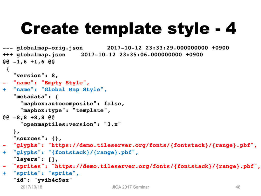
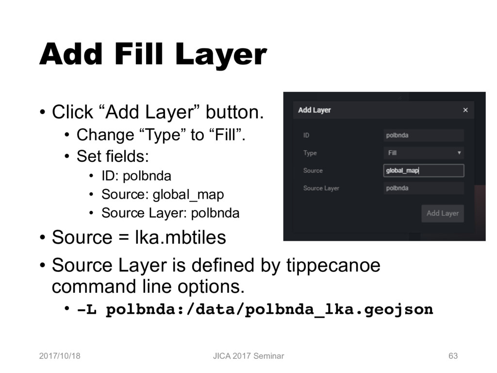
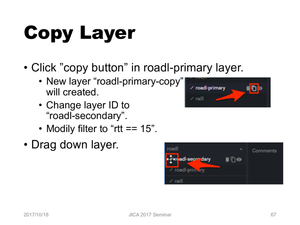
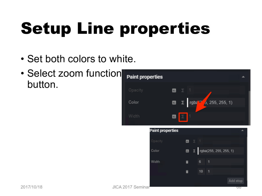
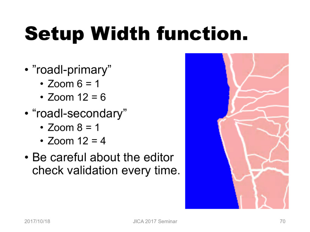
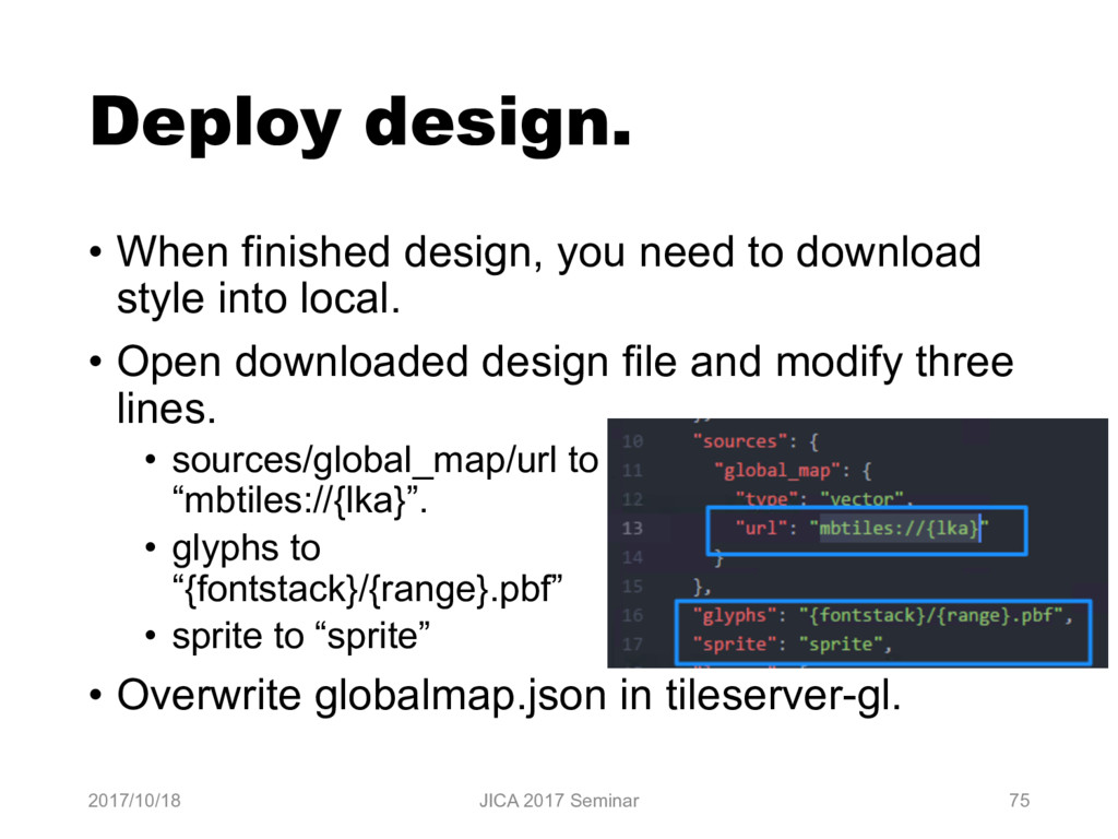
    --- globalmap-orig.json 2017-10-12 23:33:29.000000000 +0900 +++ globalmap.json 2017-10-12 23:35:06.000000000 +0900 @@ -1,6 +1,6 @@ { "version": 8, - "name": "Empty Style", + "name": "Global Map Style", "metadata": { "mapbox:autocomposite": false, "mapbox:type": "template", @@ -8,8 +8,8 @@ "openmaptiles:version": "3.x" }, "sources": {}, - "glyphs": "https://demo.tileserver.org/fonts/{fontstack}/{range}.pbf", + "glyphs": "{fontstack}/{range}.pbf", "layers": [], - "sprites": "https://demo.tileserver.org/fonts/{fontstack}/{range}.pbf", + "sprite": "sprite", "id": "yvib4c9ax"
  40. Create config file for tileserver-gl. • tileserver-gl read “config.json” file

    in current directory. 2017/10/18 JICA 2017 Seminar 49 { "options": { "paths": { "root": "", "fonts": "fonts", "sprites": "sprites", "styles": "styles", "mbtiles": "data" } }, "styles": { "globalmap": { "style": "globalmap.json" } }, "data": { "lka": { "mbtiles": "lka.mbtiles" } } }
  41. Launch maputnik in local machine • Online version of maputnik

    can’t read any file from localhost because online version run in https schema but localhost will run http schema. • It known as insecure resource issue. • maputnik can run in localhost with docker. 2017/10/18 JICA 2017 Seminar 50 > docker run --rm -it -p 8888:8888 maputnik/editor • Open localhost:8888 in Chrome browser.
  42. Setup maputnik - 1 • Your need download “GL Style”

    from tileserver- gl top page. • The name will be “style.json”. 2017/10/18 JICA 2017 Seminar 51
  43. Setup maputnik - 2 • Select “Open” in maputnik’s top

    menu. • Select “Upload” button and upload “style.json”. 2017/10/18 JICA 2017 Seminar 52
  44. Setup maputnik - 3 • Select “Sources” in maputnik’s top

    menu. • Fill “Add New Source” fields: • Source ID: global_map • Source Type: Vector (TileJSON URL) • TileJSON URL: http://localhost:8080/data/lka.json • Copy url from tileserver-gl top page. 2017/10/18 JICA 2017 Seminar 53
  45. Layers in Mapbox Style • Mapbox Style has 7 Layer

    Type. • Background • Fill • Line • Symbol • Raster • Circle • Draw circle image. • Fill Extrusion • Fill Extrusion will use 3D. • https://www.mapbox.com/mapbox-gl-js/style- spec/ 2017/10/18 JICA 2017 Seminar 54
  46. Layer - background • Fill all background with color or

    image pattern. 2017/10/18 JICA 2017 Seminar 55 Background
  47. Layer - Fill • Fill area with color or image

    pattern. 2017/10/18 JICA 2017 Seminar 56 Fill
  48. Layer - Line • Draw line with polyline features. •

    Normal line. • Dash-array. • Normal line + dash-array 2017/10/18 JICA 2017 Seminar 57
  49. Layer - Symbol • Draw image and text. • Allow

    Point, Polygon and Polyline features. 2017/10/18 JICA 2017 Seminar 58 Point Polyline Polygon
  50. Layer - Raster • Draw raster tile image. • This

    image show elevation layer. 2017/10/18 JICA 2017 Seminar 59
  51. Maputnik workflow 1. Add Layer. 1. Set basic configuration in

    dialog. 2. Setup layer properties. 1. Min Zoom & Max Zoom 2. Filter 3. Layout Properties 4. Paint / Text / Icon properties 3. Sort layer 4. Save configuration. 2017/10/18 JICA 2017 Seminar 61
  52. Add background layer • Click “Add Layer” button. • Change

    “Type” field to Background. • Background only need ID. • Set ID to ”background”. 2017/10/18 JICA 2017 Seminar 62
  53. Add Fill Layer • Click “Add Layer” button. • Change

    “Type” to “Fill”. • Set fields: • ID: polbnda • Source: global_map • Source Layer: polbnda • Source = lka.mbtiles • Source Layer is defined by tippecanoe command line options. • -L polbnda:/data/polbnda_lka.geojson 2017/10/18 JICA 2017 Seminar 63
  54. Change color in polbnda layer • Select ”polbnda” layer and

    change Color value in Paint properties. 2017/10/18 JICA 2017 Seminar 64
  55. Add Line Layer • Click “Add Layer” button. • Change

    “Type” to “Line”. • Set fields: • ID: roadl-primary • Source: global_map • Source Layer: roadl • Source Layer is defined by tippecanoe command line options. • -L roadl:/data/roadl_lka.geojson 2017/10/18 JICA 2017 Seminar 65
  56. Setup Filter • “roadl” has “Route intended use” attribute. •

    Field name is “rtt” • “rtt” = 14 is primary route. • Select ”roadl-primary” layer and click “Add filter”. • Set filter “rtt == 14”. 2017/10/18 JICA 2017 Seminar 66
  57. Copy Layer • Click ”copy button” in roadl-primary layer. •

    New layer “roadl-primary-copy” will created. • Change layer ID to “roadl-secondary”. • Modily filter to “rtt == 15”. • Drag down layer. 2017/10/18 JICA 2017 Seminar 67
  58. Setup Line properties • Set both colors to white. •

    Select zoom function button. 2017/10/18 JICA 2017 Seminar 68
  59. Zoom function • Zoom function is useful to smooth zoom.

    • Set Zoom 6 = 1 and Zoom 10 = 6, the value will increase between Zoom 6 and 10. • “base” property will use to control the rate witch the function output increases. • base = 1 will be increase linearly. • “base” property can’t edit in maputnik GUI but can edit in JSON editor. • https://www.mapbox.com/mapbox-gl-js/style- spec/#types-function 2017/10/18 JICA 2017 Seminar 69
  60. Setup Width function. • ”roadl-primary” • Zoom 6 = 1

    • Zoom 12 = 6 • “roadl-secondary” • Zoom 8 = 1 • Zoom 12 = 4 • Be careful about the editor check validation every time. 2017/10/18 JICA 2017 Seminar 70
  61. Add Symbol layer. • Click “Add Layer” button. • Change

    “Type” to “Symbol”. • Set fields: • ID: airp • Source: global_map • Source Layer: airp 2017/10/18 JICA 2017 Seminar 71
  62. Setup Icon • Select “Image” property in Icon Layout property.

    • If ”Sprite URL” is setuped, image name enable to search. • Select “airport_11”. 2017/10/18 JICA 2017 Seminar 72
  63. Setup Text - 1 • Select “Field” property in Text

    layout properties. • It can use Feature properties using token like {field_name}. • airp’s nam property is name. • Set {nam} into Field property. • But result seem wrong. • Need to set “Offset”. 2017/10/18 JICA 2017 Seminar 73
  64. Setup Text - 2 • Select ”Offset“ property. • This

    property has 2 value by default. • X and Y. • Set Y value to 1. • It seem OK and rotation is no problem too. 2017/10/18 JICA 2017 Seminar 74
  65. Deploy design. • When finished design, you need to download

    style into local. • Open downloaded design file and modify three lines. • sources/global_map/url to “mbtiles://{lka}”. • glyphs to “{fontstack}/{range}.pbf” • sprite to “sprite” • Overwrite globalmap.json in tileserver-gl. 2017/10/18 JICA 2017 Seminar 75
  66. Create raster tile from vector tile and style • Tileserver-gl

    support raster tile output. • The output url will be • http://{server}/styles/{style identifier}/{z}/{x}/{y}.png • You can access from ”raster” in top menu. 2017/10/18 JICA 2017 Seminar 77
  67. Making 4 tile set 1. Elevation 2. Land Use 3.

    Land Cover 4. Vegetation 2017/10/18 JICA 2017 Seminar 79
  68. Start QGIS and open • gmlk-10 contains All GeoTiff files

    in Sri-Lanka. 2017/10/18 JICA 2017 Seminar 80
  69. Add transparency into Elevation data • Double click el layer.

    • Select “Transparency” • Select Transparency band to None. • Add Transparenct pixel list • From 0, To 0, Percent 100. • Click OK. 2017/10/18 JICA 2017 Seminar 81
  70. Save as GeoTiff image 2017/10/18 JICA 2017 Seminar 83 •

    Save new GeoTiff Image. • Select “Rendered image” in “Output mode”. • New image will have 4 band with alpha channel.
  71. Create raster tile. • Open “Commander” in “Processing” menu. •

    Input gdal2 into commander. • Select gdalogr:gdal2tiles and input enter. 2017/10/18 JICA 2017 Seminar 84
  72. Input parameter • Select saved geotiff layer. • Extract “Advanced

    parameter”. • Set “Resampling method” to “near” • Set “Zoom levels to render” to “0-11”. • Select your directory to output. • Ex: el_tms 2017/10/18 JICA 2017 Seminar 86
  73. Convert TMS to zxy • Gdal2tiles output TMS structure tile.

    • You need to convert to zxy. • Download tms2xyz.py. • https://github.com/smellman/creating_tiles_with_glo bal_map_support_files/tree/master/2014 • Copy tms2xyz.py into created directory. • Open “OSGeo4W Shell” in Startup -> QGIS 2.x. • Change directory to output directory. • Run following: • python tms2xyz.py el_tms el 2017/10/18 JICA 2017 Seminar 88
  74. Note • Land Use, Land Cover and Vegetation doesn’t have

    “no value data” area. • If you make transparency, some data will be lost. 2017/10/18 JICA 2017 Seminar 89
  75. Vector tile hosting • Vector tile hosting is easy because

    tileserver-gl can run too many linux hosts. • But Vector tile needs SSL access in internet. • Let‘s encrypt is useful to get free SSL/TLS Certificates. • https://letsencrypt.org/ • Setup frontend server(Apache/nginx/etc) and connect from server with reverse proxy. 2017/10/18 JICA 2017 Seminar 91
  76. Raster tile hosting • If you use small number of

    data only, hosting as static image is better. • Apache / nginx / Amazon S3 / etc • Github’s gh-page is useful for free hosting. • Be careful about license. • If you use large number of data, be careful to hosting. • File system limitation: max number of files. • Ext4 on Linux: 4 billion files (specified at filesystem creation time) • File copy will slow. • Mbtiles is a solution to hosting large number of data. 2017/10/18 JICA 2017 Seminar 92
  77. Overview - nginx 2017/10/18 JICA 2017 Seminar 93 Reverse Proxy

    Internet Static contents Raster Tile Vector Tile
  78. Reverse proxy setting • In nginx, it is easy to

    setup. 2017/10/18 JICA 2017 Seminar 94 location / { proxy_set_header X-Forwarded-Proto https; proxy_set_header X-Forwarded-For $proxy_add_x_forwarded_for; proxy_set_header Host $http_host; proxy_pass http://localhost:8080; }
  79. Raster tile hosting with tileserver-gl • Tileserver-gl can deliver raster

    tile but rendering will slow. • If you use this function, you need setup cache server. 2017/10/18 JICA 2017 Seminar 95
  80. The idea • Use varnish cache for raster rendering. •

    See my presentation at StateoftheMap 2017. • http://tiny.cc/vyvaoy • https://youtu.be/aoT3FY_CTQc?t=852 2017/10/18 JICA 2017 Seminar 96