methods, a variety of spatial data generated by agriculture research and development practitioners working in and for Africa ! ! ! To illustrate the broad scope and availability of knowledge and spatial data capacities that can inform agriculture decision making & highlight the importance of smallholder agriculture in Africa ! What is the eAtlas? What is the main goal?
Consolidated showcase of data related to African agriculture research and development • Involves a broad base of contributors both within and outside the CGIAR system • Helps identify and provide linkages between researchers, organizations & data • Provides value added supporting text, figures & links related to the mapped data • Serve as a gateway to contributing organizations sites and supporting documents • Increases exposure & discoverability of data and research (Data doesn’t become a DUD* … Data Undiscoverable on Drive) • Pathway to ‘open access’ • Able to evolve over time in response to changing needs and resources • Aims to reach a broad audience through a variety of distribution means * Enterprise that proves to be a failure
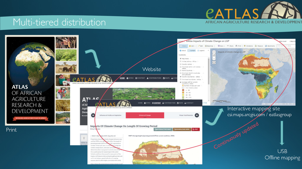
levels of accessibility to the internet ! • Target audience: Researchers, donors, educators, policymakers, investors, extension workers, citizens, and other decision makers ! • Formats: Currently available in print, PDF, online through a website & an online interactive mapping … (phase 2) offline interactive mapping tool & easier data access ! • Outreach: Print & site launch in July; IFPRI marketing; twitter; FB; via contributors; need more ! What are the distribution goals?
• Visualization & introduction of map(s) • Consistent presentation & thematic grouping • Cross linkages within atlas (e.g. use of livestock systems data in study on trypanosomosis) • Understanding of story the data is telling, why it’s important and where to learn more = broader exposure (& validation) of your data! • Easy opportunity for you to share data (for non-commercial purposes) • Links to originating organization and data download • Draws users to contributor’s site and other research • Accessible by a broad audience - NOT QUITE THERE YET
website & distribution of print copies, contributors, word of mouth • Twitter, other social media • CSI extended ! • Putting the ‘e’ back in eAtlas • Make available all maps through (online) interactive mapping tool - ‘live updates’ • ArcGIS Online • Adding download options – contributors site; AGOL - Image data or are tiles enough? • Updating datasets ! • Continue to add content to the atlas (website and interactive) • Opportunity to participate • Fill in the gaps (e.g. Bioversity, Human welfare, Aquaculture, Crop specific) • Sub-regional examples (e.g. N2Africa) • Institutional groupings (e.g. ASARECA) • CRP maps? ! • Establishing ‘home’ for eAtlas project under Spatial Commons initiative
current offerings? • print/pdf; Website; AGOL maps, layers & download capabilities (features/tiles) ! How do we make the atlas a (more) useful resource? • Create more robust interactive site – more analysis? Overlays? But maintain value added components • Increase data access – image services? • Links back to other portals, sites, etc… • Multilingual? Reality of reaching multiple audiences? • How? Who? Plan for offline distribution? • Interactive mapping / data tool via USB How best to expand? Content? Or Extent? Or Functionality? • Deeper into themes - More regional focus - More global focus • Add functions and features ! How does this tie into Spatial Commons / Open Access CSI goals? • Opportunity to highlight flagship datasets • Data standardization & open access How encourage participation? • As part of Spatial Commons/Open Access initiative • Workshops, Other support (e.g. tools for uploading data, templates, mapping) • Direct solicitation • Word of mouth / other contributors ! !