Upgrade to Pro — share decks privately, control downloads, hide ads and more …

Mapping Agricultural Investments and Technologies

CGIAR-CSI
September 24, 2014

Mapping Agricultural Investments and Technologies

test

CGIAR-CSI

September 24, 2014
Tweet

More Decks by CGIAR-CSI

Other Decks in Research

Transcript

  1. Mapping Agricultural Investments and Technologies MAPPING THE LOCATION AND REACH

    OF CGIAR RESEARCH PROGRAMS
 FOR IMPROVED PLANNING AND TARGETING. CSI 2014, ITC Enschede, Sep 22-24, 2014
  2. CRP Leaders Annual Meeting, Montpellier, June 4, 2014 Rationale ✓

    Provide the CG System and our partners with simple investment indicators:! • Location of R&D focus areas, programs, and actors! • Count of activities, allocated budget by activity, with additional allocation across Common IDOs and CRP IDOs, commodity value-chains, and technologies! • Support for investment analysis and targeting with partners (identify gaps and opportunities to foster partnerships at regional, national, and local scale)! ✓ Align with CGIAR Open-Access Policy and contribute to agricultural data-sharing standards! ✓ Contribute to building a spatially-referenced inventory of CGIAR technologies and research methods 2
  3. CRP Leaders Annual Meeting, Montpellier, June 4, 2014 Not in

    scope ▪ Provide detailed records of financial transactions! • Currently no ties to One Corporate System (might be desirable to align with OCS project definitions?)! • Not a substitute for the CRPs’ own reporting systems (but facilitates data sharing across systems)! ▪ Track results and performance indicators! • No disclosed measure of program or activity performance (only allocated budget amounts)! • Currently no link to research output, journal articles, annual reports, or datasets (but feasible, similar to DfID Development Tracker)! ▪ Track people/researchers, encourage social networking! • Currently does not track “who works where”, “what’s new”, etc. (but links to Yammer-like social platforms or Office 365 could be envisioned) 3
  4. CRP Leaders Annual Meeting, Montpellier, June 4, 2014 ! !

    ! ! ! ! ! 
 Nicaragua, April 28, 2014! CIAT, CIP, CIMMYT, ICRAF, CIRAD, CATIE, CRS, BIOVERSITY: How to better integrate CRP activities in Central America?! 64 activities cataloged and mapped/1 day ! ! ! ! ! ! ! ! ! Addis, May 12, 2014
 ILRI Mapathon: mapping CGIAR activities in the Horn of Africa.! 20 participants (ILRI, ICRAF, IWMI, ICARDA, CIP), data-entry is on-going! Support Investment targeting at regional and local scales 4
  5. CRP Leaders Annual Meeting, Montpellier, June 4, 2014 5 Data

    Standardizati on! IATI, AGROVOC, Crop Ontology Tool, CGIAR Data Standards WG CGIAR/CRP Agricultural R&D Domain Mapping! CSI reps, CGIAR GIS Analysts Unstructured Country-level Geocoding! CRP annual progress reports, PoWBs, CRP websites, etc. Structured Activity-level Geocoding! Worksheets, workshops, project websites Cataloging! Publishing Harmoniz ation! Geocodin g Curation
 Data Linking
 Publishing Linked open data, RDF
 http://data.ifpri.org/ lod/at CGIAR ArcGISOnline! http:// csi.maps.arcgis.com/ Harmonized country-level and activity-level investment indicators! http://public.tableausoftware.com/ views/CRPsbyCountryJun2014/ World?&:showVizHome=no CGIAR Investmen t Mapping Tool
 http://54.83.200.172/ crp-pmtv/ Workstream s
  6. CRP Leaders Annual Meeting, Montpellier, June 4, 2014 Contributions CRP

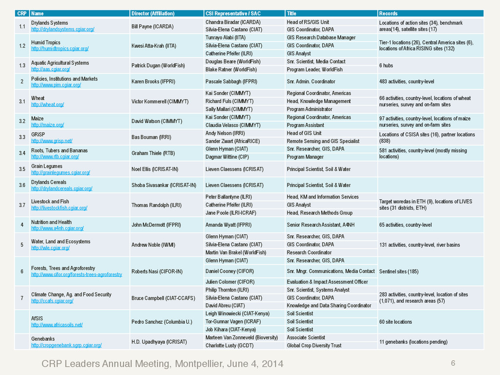
    Name Director (Affiliation) CSI Representative / SAC Title Records 1.1 Drylands Systems http://drylandsystems.cgiar.org/ Bill Payne (ICARDA) Chandra Biradar (ICARDA) Head of RS/GIS Unit Locations of action sites (34), benchmark areas(14), satellite sites (17) Silvia-Elena Castano (CIAT) GIS Coordinator, DAPA 1.2 Humid Tropics http://humidtropics.cgiar.org/ Kwesi Atta-Krah (IITA) Tunrayo Alabi (IITA) GIS Research Database Manager Tier-1 locations (26), Central America sites (6), locations of Africa RISING sites (132) Silvia-Elena Castano (CIAT) GIS Coordinator, DAPA Catherine Pfeifer (ILRI) GIS Analyst 1.3 Aquatic Agricultural Systems http://aas.cgiar.org/ Patrick Dugan (WorldFish) Douglas Beare (WorldFish) Snr. Scientist, Media Contact 6 hubs Blake Ratner (WorldFish) Program Leader, WorldFish 2 Policies, Institutions and Markets http://www.pim.cgiar.org/ Karen Brooks (IFPRI) Pascale Sabbagh (IFPRI) Snr. Admin. Coordinator 483 activities, country-level 3.1 Wheat http://wheat.org/ Victor Kommerell (CIMMYT) Kai Sonder (CIMMYT) Regional Coordinator, Americas 66 activities, country-level, locations of wheat nurseries, survey and on-farm sites Richard Fuls (CIMMYT) Head, Knowledge Management Sally Mallari (CIMMYT) Program Administrator 3.2 Maize http://maize.org/ David Watson (CIMMYT) Kai Sonder (CIMMYT) Regional Coordinator, Americas 97 activities, country-level, locations of maize nurseries, survey and on-farm sites Claudia Velasco (CIMMYT) Program Assistant 3.3 GRiSP http://www.grisp.net/ Bas Bouman (IRRI) Andy Nelson (IRRI) Head of GIS Unit Locations of CSISA sites (16), partner locations (838) Sander Zwart (AfricaRICE) Remote Sensing and GIS Specialist 3.4 Roots, Tubers and Bananas http://www.rtb.cgiar.org/ Graham Thiele (RTB) Glenn Hyman (CIAT) Snr. Researcher, GIS, DAPA 581 activities, country-level (mostly missing locations) Dagmar Wittine (CIP) Program Manager 3.5 Grain Legumes http://grainlegumes.cgiar.org/ Noel Ellis (ICRISAT-IN) Lieven Claessens (ICRISAT) Principal Scientist, Soil & Water 3.6 Drylands Cereals http://drylandcereals.cgiar.org/ Shoba Sivasankar (ICRISAT-IN) Lieven Claessens (ICRISAT) Principal Scientist, Soil & Water 3.7 Livestock and Fish http://livestockfish.cgiar.org/ Thomas Randolph (ILRI) Peter Ballantyne (ILRI) Head, KM and Information Services Target woredas in ETH (9), locations of LIVES sites (31 districts, ETH) Catherine Pfeifer (ILRI) GIS Analyst Jane Poole (ILRI-ICRAF) Head, Research Methods Group 4 Nutrition and Health http://www.a4nh.cgiar.org/ John McDermott (IFPRI) Amanda Wyatt (IFPRI) Senior Research Assistant, A4NH 65 activities, country-level 5 Water, Land and Ecosystems http://wle.cgiar.org/ Andrew Noble (IWMI) Glenn Hyman (CIAT) Snr. Researcher, GIS, DAPA 131 activities, country-level, river basins Silvia-Elena Castano (CIAT) GIS Coordinator, DAPA Martin Van Brakel (WorldFish) Research Coordinator 6 Forests, Trees and Agroforestry http://www.cifor.org/forests-trees-agroforestry Roberts Nasi (CIFOR-IN) Glenn Hyman (CIAT) Snr. Researcher, GIS, DAPA Sentinel sites (185) Daniel Cooney (CIFOR) Snr. Mngr. Communications, Media Contact Julien Colomer (CIFOR) Evaluation & Impact Assessment Officer 7 Climate Change, Ag. and Food Security http://ccafs.cgiar.org/ Bruce Campbell (CIAT-CCAFS) Philip Thornton (ILRI) Snr. Scientist, Systems Analyst 283 activities, country-level, location of sites (1,071), and research areas (57) Silvia-Elena Castano (CIAT) GIS Coordinator, DAPA David Abreu (CIAT) Knowledge and Data Sharing Coordinator AfSIS http://www.africasoils.net/ Pedro Sanchez (Columbia U.) Leigh Winowiecki (CIAT-Kenya) Soil Scientist 60 site locations Tor-Gunnar Vagen (ICRAF) Soil Scientist Job Kihara (CIAT-Kenya) Soil Scientist Genebanks http://cropgenebank.sgrp.cgiar.org/ H.D. Upadhyaya (ICRISAT) Marteen Van Zonneveld (Bioversity) Associate Scientist 11 genebanks (locations pending) Charlotte Lusty (GCDT) Global Crop Diversity Trust 6
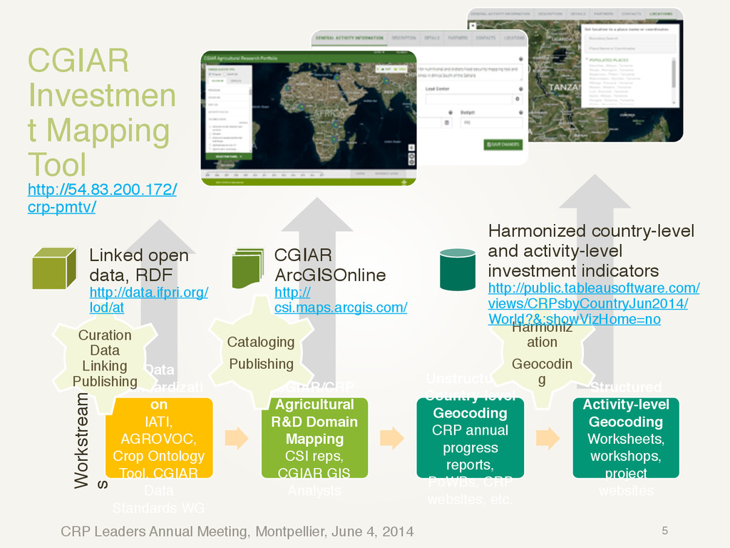
  7. CRP Leaders Annual Meeting, Montpellier, June 4, 2014 2015/16 Workplan

    (tentative) 7 Deliverables Deliverable format Estimated date of completion Gender focus 2015 Internal release of CGIAR PMT (limited to CGIAR staff and partners with partial coverage of CRP activities) Website/tool 01/01/2015 None Initial public release of CGIAR PMT (with only partial coverage of CRP activities, but showing investment summaries) Website/tool 05/01/2015 None 2015 Report on CGIAR Spatial R&D Footprint and Strategic Relevance Report 03/01/2015 None Version 2.0 of the AT Ontology Website/Dataset 01/01/2015 Significant Version 2.0 of the CGIAR Partner Ontology Website/Dataset 02/01/2015 None Version 1.0 of the CGIAR Place Name database (listing locations of research stations, experimental farms, and partner organizations) Tool/Dataset 06/01/2015 None CIAT Mapathon Training 03/01/2015 None CIMMYT Mapathon Training 02/01/2015 None 2016 ICRISAT Mapathon Training 01/01/2016 None Release 2.0 of CGIAR PMT (with linkages to research publications and datasets and improved spatial coverage of CRP activities) Website/Tool 02/01/2016 None Version 3.0 of the AT Ontology Website/Dataset 02/01/2016 Significant Version 3.0 of the CGIAR Place Name database (also listing names and locations of CRP focus areas) Website/Dataset 06/01/2016 None 2016 Report on CGIAR Spatial R&D Footprint and Strategic Relevance Report 09/01/2016 None
  8. CRP Leaders Annual Meeting, Montpellier, June 4, 2014 IATI-driven R&D

    Mapping International Aid Transparency Initiative: multi- stakeholder (over 160 organizations) launched in Ghana, 2008.! IATI largely builds on OECD/DAC coding standards.! However, generally poor coverage and details on agriculture.! http://iatistandard.org/ 8
  9. CRP Leaders Annual Meeting, Montpellier, June 4, 2014 Harmonized Vocabularies

    ▪ Strategic themes: CGIAR SLOs, System and CRP IDOs! ▪ Target technologies: draft ontology is now at http://data.ifpri.org/lod/at (needs expert review from KM Leaders and/or Data Standards Working Group)! ▪ Target commodities: currently using FAO/AGROVOC commodity names! ▪ Organizations: harmonized organization/partner identifiers now using CGIAR RDF at http://open.cgiar.org/institutions.rdf ! ▪ Collaboration types: 1-Bilateral, 2-Multilateral, 201-CGIAR Window-1/2, 202-CGIAR window-3, 101-CGIAR Bilateral, 3-Bilateral, core contributions to NGOs and other private bodies / PPPs, 4- Multilateral outflows, 6- Private sector outflow! ▪ Location reach: 100-Activity or Intervention, 101-Conference, Meeting, Workshop, or Training Event, 102-Partners, 103- Permanent Agricultural Trial Site, 200-Potential beneficiaries! ▪ Location precision: 101-Multi-Country, 102-Country (level-0), 103-Province (level-1), 104-District (level-2), 105-Ward (level-3), 200-Populated Place, 301-CGIAR Center, 302- Permanent Agricultural Trial Site, 300-Structure (other), 401-River Basin, 402-Other CGIAR Research Area, 400-Other Topographical Feature 10
  10. CRP Leaders Annual Meeting, Montpellier, June 4, 2014 CRP Action

    Sites and Focus Areas
http:// csi.maps.arcgis.com/home/webmap/viewer.html?webmap=1fd97e26f6124792bac11ba527511674 11
  11. CRP Leaders Annual Meeting, Montpellier, June 4, 2014 ! !

    ! ! ! ! ! ! CGIAR Research Stations (May, 2014)! http://csi.maps.arcgis.com/home/ webmap/viewer.html? webmap=363f575f3a134a45b28043 27c1d236b8 ! ! ! ! ! ! ! ! AgTrials Sites (May, 2014)! http://csi.maps.arcgis.com/home/ webmap/viewer.html? webmap=0bb072e3bd5a498d91e 6191b59624e66 Locations of CGIAR Research Stations 12
  12. CRP Leaders Annual Meeting, Montpellier, June 4, 2014 CGIAR R&D

    Spatial Footprint: country-level
https://hc.app.box.com/s/39pgky4jn1frrek30d8z (print, as of Nov. 2013)
http://public.tableausoftware.com/views/CRPsbyCountryJun2014/World?&:showVizHome=no (interactive, as of Jun. 2014) 13
  13. CRP Leaders Annual Meeting, Montpellier, June 4, 2014 From worksheets

    to robust interactive data-entry tools New web-based tool:! – Provides robust data validation! – Geocoding is built-in and simple! – No further data transformation required! Early website release at http:// pmte.cgiar.org/ (super/super) 14 Search through existing activities across programs Simplified editing tools and workflow
  14. CRP Leaders Annual Meeting, Montpellier, June 4, 2014 From worksheets

    to robust interactive data-entry tools New web-based tool:! – Provides robust data validation! – Geocoding is built-in and simple! – No further data transformation required! Early website release at http:// pmte.cigar.org/ (super/super) 15 2) Alternatively, use familiar drawing tools to locate specific points or areas. 1) Search map for administrative names, place names, or other known locations 3) Specify a location reach and location precision.
  15. CRP Leaders Annual Meeting, Montpellier, June 4, 2014 CGIAR Research

    Portfolio
http://where.cigar.org/ (super/ super) 16 Clustered view of research activities by CRP, by Common IDO, across technology, etc. Filter and save/ export activities across key dimensions View activity summaries across zones (not yet implemented ) Overlay socio- economic and biophysical maps Explore activity partners and contact details
  16. CRP Leaders Annual Meeting, Montpellier, June 4, 2014 PMT-e (activity

    editor)
http://pmte.cgiar.org/ CRP PMT Editor Training Users User name Password user1 super1 user2 super2 user3 super3 user4 super4 user5 super5 user6 super6 user7 super7 user8 super8 user9 super9 user10 super10 user11 super11 user12 super12 17
  17. Thank You Direct questions to Melanie Bacou (IFPRI) [email protected] and

    Glenn Hyman (CIAT) [email protected]. ! ! ! Visit http://www.cgiar-csi.org/.