Upgrade to Pro — share decks privately, control downloads, hide ads and more …

GeoBIM for building permits issuing

GeoBIM for building permits issuing

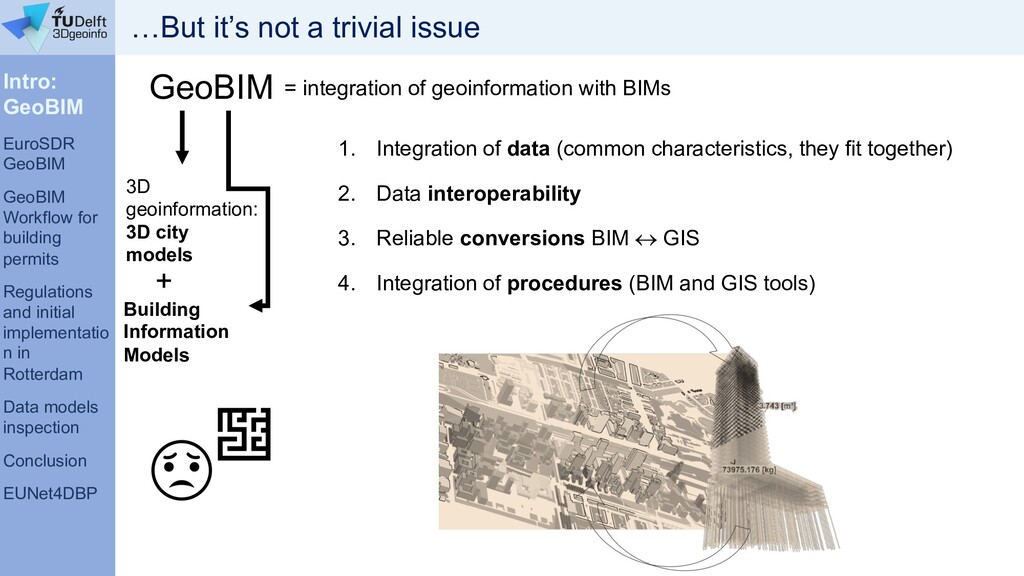
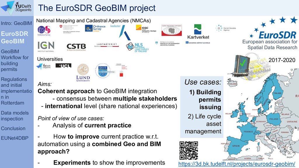
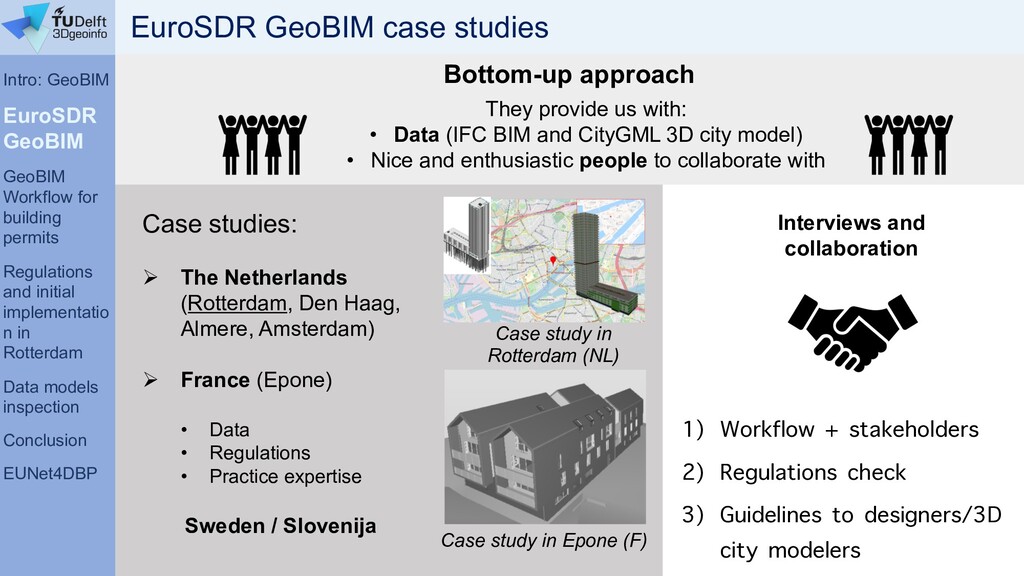
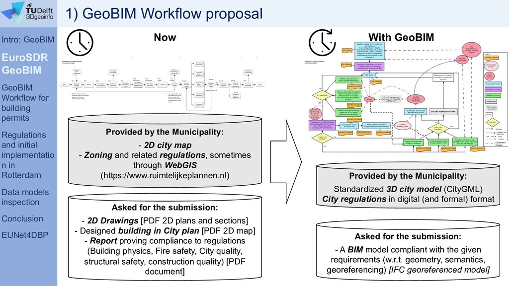
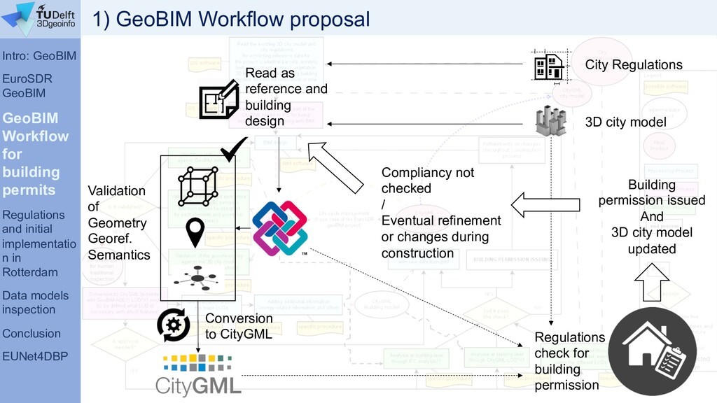
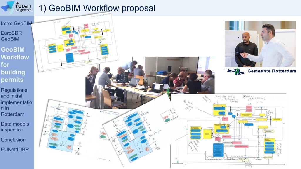
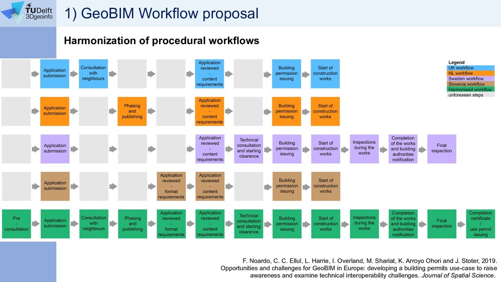
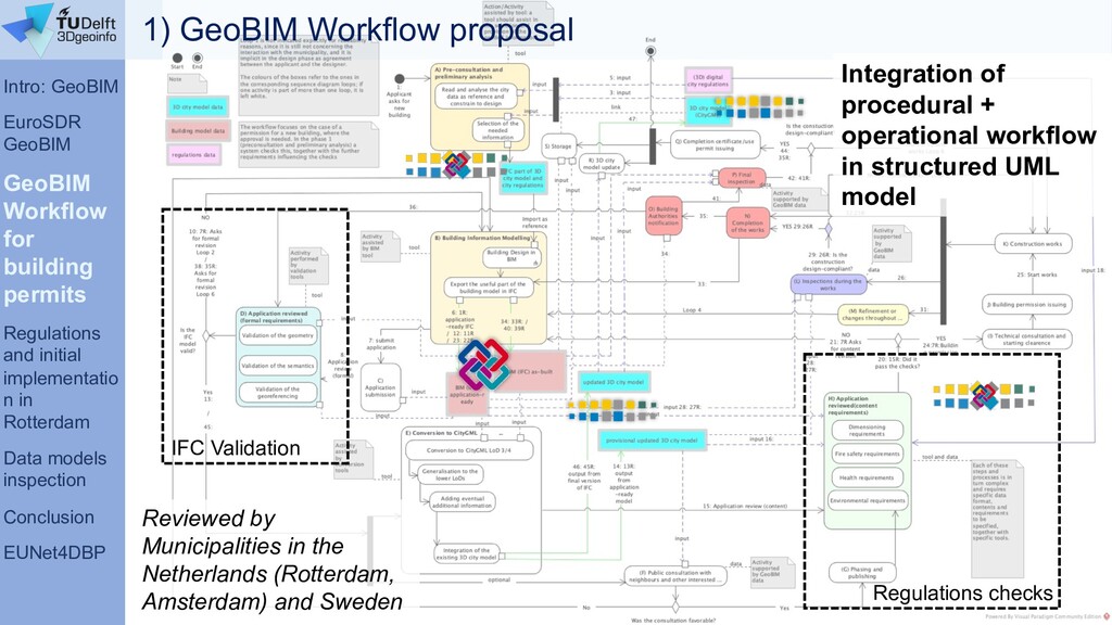
Presentation of a work towards the implementation of a tool supporting building permits process by means of digital information, developed within a project funded by the Municipality of Rotterdam (NL). Moreover, the European network for Digital Building Permits is presented for the first time.
The presentation was given at the "BIM-based Building Permit Process Automation Seminar", pre-conference event of the WDBE2020, in Tallin (Estonia) https://kirahub.org/en/wdbe2020/pre-event-2/

Francesca Noardo

February 20, 2020
Tweet

More Decks by Francesca Noardo

Other Decks in Research

Transcript

  1. GeoBIM for building permits issuing Francesca Noardo 3D geoinformation group

    Delft University of Technology, NL 20th February 2020
  2. Overview 1) Introduction: 3D city models and GeoBIM 2) The

    EuroSDR GeoBIM project 3) A new workflow for the building permits issuing using GeoBIM 4) Investigating regulations and initial implementation in the project “GeoBIM for Building Permits in Rotterdam” 5) Data models inspection: models from practice 6) Conclusion and final remarks 7) The European Network for Digital Building Permits
  3. Intro: GeoBIM EuroSDR GeoBIM GeoBIM Workflow for building permits Regulations

    and initial implementatio n in Rotterdam Data models inspection Conclusion EUNet4DBP Evolution of common GIS; In cartographic field and city management (not pushed by industry!); Usually oriented to the representation of medium levels of detail objects (e.g. ~20 cm accuracy); Storage of all the coordinates composing a surface (explicit representation) Geometry Buildings Vegetation Roads Water City Semantics City representation and management aims Georeferencing 3D GIS – 3D city models Boundary Representation Aggregation of boundary surfaces, enclosing the body completely.
  4. Intro: GeoBIM EuroSDR GeoBIM GeoBIM Workflow for building permits Regulations

    and initial implementatio n in Rotterdam Data models inspection Conclusion EUNet4DBP X solar potential shadow analysis noise modelling energy estimation bomb detonation wind turbulence pollutant tracking 3D cadastre 3D archive Multitemporal analysis Risk assessment… Navigation Flood simulations Multivariate analysis 3D GIS – 3D city models: functionalities
  5. Intro: GeoBIM EuroSDR GeoBIM GeoBIM Workflow for building permits Regulations

    and initial implementatio n in Rotterdam Data models inspection Conclusion EUNet4DBP High level of detail 3D cadaster No tasks duplication (3D data collection) Efficient databases updates without additional costs Effective data exchange with professionals (architects, engineers, environmental scientists, etc.) Stronger information for lifecycle asset management & city analysis Context for design reference Improved test of building properties: designed building into its context Test of the impact of the building on the city or landscape. Multiscale vision (from construction elements to whole territories) BIM world point of view GEO world point of view = integration of geoinformation with BIMs GeoBIM Building Information Models 3D geoinformation: 3D city models + Great advantages from integration
  6. Intro: GeoBIM EuroSDR GeoBIM GeoBIM Workflow for building permits Regulations

    and initial implementatio n in Rotterdam Data models inspection Conclusion EUNet4DBP 1. Integration of data (common characteristics, they fit together) 2. Data interoperability 3. Reliable conversions BIM « GIS 4. Integration of procedures (BIM and GIS tools) GeoBIM Building Information Models 3D geoinformation: 3D city models + = integration of geoinformation with BIMs …But it’s not a trivial issue
  7. Intro: GeoBIM EuroSDR GeoBIM GeoBIM Workflow for building permits Regulations

    and initial implementatio n in Rotterdam Data models inspection Conclusion EUNet4DBP https://3d.bk.tudelft.nl/projects/eurosdr-geobim/ Aims: Coherent approach to GeoBIM integration - consensus between multiple stakeholders - international level (share national experiences) Point of view of use cases: - Analysis of current practice - How to improve current practice w.r.t. automation using a combined Geo and BIM approach? - Experiments to show the improvements National Mapping and Cadastral Agencies (NMCAs) 2017-2020 European association for Spatial Data Research Universities Use cases: 1) Building permits issuing 2) Life cycle asset management The EuroSDR GeoBIM project
  8. Intro: GeoBIM EuroSDR GeoBIM GeoBIM Workflow for building permits Regulations

    and initial implementatio n in Rotterdam Data models inspection Conclusion EUNet4DBP Bottom-up approach Case study in Rotterdam (NL) Case study in Epone (F) They provide us with: • Data (IFC BIM and CityGML 3D city model) • Nice and enthusiastic people to collaborate with EuroSDR GeoBIM case studies Case studies: Ø The Netherlands (Rotterdam, Den Haag, Almere, Amsterdam) Ø France (Epone) • Data • Regulations • Practice expertise Sweden / Slovenija 1) Workflow + stakeholders 2) Regulations check 3) Guidelines to designers/3D city modelers Interviews and collaboration
  9. Intro: GeoBIM EuroSDR GeoBIM GeoBIM Workflow for building permits Regulations

    and initial implementatio n in Rotterdam Data models inspection Conclusion EUNet4DBP Now With GeoBIM Asked for the submission: - 2D Drawings [PDF 2D plans and sections] - Designed building in City plan [PDF 2D map] - Report proving compliance to regulations (Building physics, Fire safety, City quality, structural safety, construction quality) [PDF document] Asked for the submission: - A BIM model compliant with the given requirements (w.r.t. geometry, semantics, georeferencing) [IFC georeferenced model] Provided by the Municipality: - 2D city map - Zoning and related regulations, sometimes through WebGIS (https://www.ruimtelijkeplannen.nl) Provided by the Municipality: Standardized 3D city model (CityGML) City regulations in digital (and formal) format 1) GeoBIM Workflow proposal
  10. Intro: GeoBIM EuroSDR GeoBIM GeoBIM Workflow for building permits Regulations

    and initial implementatio n in Rotterdam Data models inspection Conclusion EUNet4DBP City Regulations 3D city model Read as reference and building design Validation of Geometry Georef. Semantics Conversion to CityGML Regulations check for building permission Building permission issued And 3D city model updated Compliancy not checked / Eventual refinement or changes during construction 1) GeoBIM Workflow proposal
  11. Intro: GeoBIM EuroSDR GeoBIM GeoBIM Workflow for building permits Regulations

    and initial implementatio n in Rotterdam Data models inspection Conclusion EUNet4DBP 1) GeoBIM Workflow proposal
  12. 1) GeoBIM Workflow proposal Harmonization of procedural workflows F. Noardo,

    C. C. Ellul, L. Harrie, I. Overland, M. Shariat, K. Arroyo Ohori and J. Stoter, 2019. Opportunities and challenges for GeoBIM in Europe: developing a building permits use-case to raise awareness and examine technical interoperability challenges. Journal of Spatial Science.
  13. Intro: GeoBIM EuroSDR GeoBIM GeoBIM Workflow for building permits Regulations

    and initial implementatio n in Rotterdam Data models inspection Conclusion EUNet4DBP IFC Validation Regulations checks Integration of procedural + operational workflow in structured UML model Reviewed by Municipalities in the Netherlands (Rotterdam, Amsterdam) and Sweden 1) GeoBIM Workflow proposal
  14. Intro: GeoBIM EuroSDR GeoBIM GeoBIM Workflow for building permits Regulatio

    ns and initial implement ation in Rotterdam Data models inspection Conclusion EUNet4DBP Zoning and dimensions: max height, volume, densification, distances (overhanging objects, balconies), pipe heights (restaurants). Impact of the building in environment and of environment on the building: shadows analysis, noise analysis, air quality, energy. Accessibility of the buildings in higher detail: disabled accessibility and usability, and escape routes planning. Structural safety in complex cases, e.g.; Amsterdam cellars; terrain deformations (bridges parts misalignments);… Parking availability and plans connected to the new buildings 2) Regulations most effectively checked through GeoBIM
  15. Intro: GeoBIM EuroSDR GeoBIM GeoBIM Workflow for building permits Regulatio

    ns and initial implement ation in Rotterdam Data models inspection Conclusion EUNet4DBP GeoBIM for Building Permits in Rotterdam The automation of the regulation checks is further explored. Two regulations: • Building dimensions • Provision of parking places Close collaboration with the municipality officers usually devoted to the interpretation of such rules. Use of BIM, 3D city model data, regulations information to test the methodology in a case study. Outcomes: Ø a tool, allowing the automatic or semi-automatic checks of the compliancy to the selected regulations using a BIM model and a 3D city model as input. Ø Guidelines and recommendations, to designers and city modelers, to produce effective models for this aim. December 2019 – August 2020
  16. Intro: GeoBIM EuroSDR GeoBIM GeoBIM Workflow for building permits Regulatio

    ns and initial implement ation in Rotterdam Data models inspection Conclusion EUNet4DBP 1. Spatial planning (admissibility test) 2. Construction 3. Fire prevention 4. Usability test 5. Building physics 6. Architectural aspects 5 – 15 weeks Rotterdam current process and regulations fields
  17. Intro: GeoBIM EuroSDR GeoBIM GeoBIM Workflow for building permits Regulatio

    ns and initial implement ation in Rotterdam Data models inspection Conclusion EUNet4DBP Pilot area
  18. Intro: GeoBIM EuroSDR GeoBIM GeoBIM Workflow for building permits Regulatio

    ns and initial implement ation in Rotterdam Data models inspection Conclusion EUNet4DBP 2) Regulations check: Maximum dimensions
  19. Intro: GeoBIM EuroSDR GeoBIM GeoBIM Workflow for building permits Regulatio

    ns and initial implement ation in Rotterdam Data models inspection Conclusion EUNet4DBP 2) Regulations check: human challenges I Workshop 16/10/2019 – Building dimensions and parking spaces design in the city regulations II Workshop 05/11/2019 – External experts involved in building permission issuing (Fire safety, structural safety, City aesthetics, Building physics) Persuading operators Regulations interpretation
  20. Intro: GeoBIM EuroSDR GeoBIM GeoBIM Workflow for building permits Regulatio

    ns and initial implement ation in Rotterdam Data models inspection Conclusion EUNet4DBP Regulation text: “The maximum building height is 100 meters, on the understanding that it can be realized with a substructure of a maximum of 17 meters high and a construction of a maximum of 50% of the surface of the substructure. At the location of Boompjes 60-68 and Boompjes 55-58, an overhang of 5 meters on the Boompjes side and 10 meters on the Hertekade side is permitted”. 2) Regulations check: human challenges
  21. Intro: GeoBIM EuroSDR GeoBIM GeoBIM Workflow for building permits Regulatio

    ns and initial implement ation in Rotterdam Data models inspection Conclusion EUNet4DBP Regulation text: “The maximum building height is 100 meters, on the understanding that it can be realized with a substructure of a maximum of 17 meters high and a construction of a maximum of 50% of the surface of the substructure. At the location of Boompjes 60-68 and Boompjes 55-58, an overhang of 5 meters on the Boompjes side and 10 meters on the Hertekade side is permitted”.
  22. Intro: GeoBIM EuroSDR GeoBIM GeoBIM Workflow for building permits Regulatio

    ns and initial implement ation in Rotterdam Data models inspection Conclusion EUNet4DBP BIM Requirements Premises: - All the IFC files being part of the BIM must be in the same CRS - Georeferencing information in a projected coordinate reference system must be provided in the BIM - Good quality semantics have to be stored in the BIM (e.g. consistent grouping in IfcStoreys, separate IfcSite elements and IfcBuilding elements clearly…)
  23. Intro: GeoBIM EuroSDR GeoBIM GeoBIM Workflow for building permits Regulatio

    ns and initial implement ation in Rotterdam Data models inspection Conclusion EUNet4DBP Translation to ‘formal’ language and information mapping 2) Regulations check: information challenges
  24. Intro: GeoBIM EuroSDR GeoBIM GeoBIM Workflow for building permits Regulatio

    ns and initial implement ation in Rotterdam Data models inspection Conclusion EUNet4DBP Height calculation: From BIM + 3D city model (we need the terrain intersection) Building parts reciprocal relationships and dimensions: From BIM + use of typical “geo” concepts, like generalization and boundary representation Calculation of overhangs towards the two streets: From BIM + 3D city model (which face is towards which street?) 2) Regulations check: information challenges
  25. Intro: GeoBIM EuroSDR GeoBIM GeoBIM Workflow for building permits Regulatio

    ns and initial implement ation in Rotterdam Data models inspection Conclusion EUNet4DBP We need vertical discontinuities to find building parts 2) Regulations check: information challenges
  26. Intro: GeoBIM EuroSDR GeoBIM GeoBIM Workflow for building permits Regulatio

    ns and initial implement ation in Rotterdam Data models inspection Conclusion EUNet4DBP IfcBuildingElements ----> Points --- --> Alpha shape boundary (CGAL) Implementing… IfcOpenShell OpenCascade
  27. Intro: GeoBIM EuroSDR GeoBIM GeoBIM Workflow for building permits Regulations

    and initial implementatio n in Rotterdam Data models inspection Conclusion EUNet4DBP IFC models sample inspection 24 1 1 1 9 Total: 36 models Autodesk Revit WoonConnect Graphisoft Archicad RDF Ltd. Modelling Software • NIST IFC file analyzer • Manual inspection in BIM Viewers (Solibrí Model Viewer, IFCViewer, FZKViewer) • Text format inspection We asked for it expressely 0 2 4 6 8 10 12 14 16 18 20 2012 2014 2015 2016 2017 2018 2019 Export Year Year and IFC version of inspected models IFC 2x3 CoordinationView IFC 4 DesignTransferView IFC models from practice We would like to increase the sample… Starting point to write good guidelines
  28. Intro: GeoBIM EuroSDR GeoBIM GeoBIM Workflow for building permits Regulations

    and initial implementatio n in Rotterdam Data models inspection Conclusion EUNet4DBP IFC models sample inspection Features affecting the potential quality of conversions Well used, 16 Partially used, 1 Not used, 7 Not applicable, 12 Use of IfcSpace Bias factors: + Models involved in projects about BIM/GeoBIM + 10 (good) Models part of same complex - Infrastructure (roundabout) models, different from Building models - Architectural / structural / installations None 17% Few, used correctly 11% Some, instead of correct entity 43% Many, instead of correct entity 17% All 3% Installation models not analysed 9% Use of IfcBuildingElementProxy 6 9 10 8 6 6 8 9 9 10 1 10 10 9 9 9 9 9 9 9 9 9 9 9 7 7 10 2 7 10 6 9 10 9 1 6 10 8 9 9 9 9 9 9 9 9 9 9 7 9 9 6 9 8 7 9 8 9 6 10 10 8 9 9 9 9 9 9 9 9 9 9 2 5 9 9 8 10 10 9 10 9 6 10 7 8 10 10 10 10 10 10 10 10 10 10 0 5 10 15 20 25 30 35 40 M odel 1 M odel 2 M odel 11 M odel 15 M odel 16 M odel 17 M odel 19 M odel 20 M odel 21 M odel 22 M odel 23 M odel 24 M odel 25 M odel 26 M odel 27 M odel 28 M odel 29 M odel 30 M odel 31 M odel 32 M odel 33 M odel 34 M odel 35 M odel 36 Scores Qualitative assessment IfcOpening use Grouping in storeys Materials assigned Consistent entities Precise: CRS coordinate s in IfcSite and TrueNorth 5% Precise: CRS coordinate s in IfcSite 33% Unprecise: city coordinates in IfcSite 25% Very Unprecise: Point close to Country 3% Local 31% Wrong 3% Georeferencing
  29. Intro: GeoBIM EuroSDR GeoBIM GeoBIM Workflow for building permits Regulations

    and initial implementatio n in Rotterdam Data models inspection Conclusio n EUNet4DBP • Complexity (data issue, regulation issue, technical issue, human issue…) • Hard work to set cross-fields collaborations and consensus but it started successfully • Specific steps to fill the workflow boxes • The bottom-up approach, starting very specifically from one regulation in one parcel in Rotterdam allowed to enlighten the concrete problems which are at the base of any regulation check with the involved digital data (how to extract limits, surfaces, references, directions). Conclusions Towards automatic building permits
  30. European Network for Digital Building Permits “European” since we agreed

    that for the moment we are mainly focussed on Europe and we are strongly related to European state of art. Although this, we are open to any other Countries to collaborate with us and be involved.
  31. Sweden The Netherlands France UK Poland National Experiences overview Ireland

    Finland Denmark Slovenia Norway European Directive 2014/24/EU, strongly encouraging the use of BIM for public projects. à In many countries from 2018 a process began towards the mandatory adoption of BIM at least for public buildings, generally to be fulfilled by 2022 European network for Digital Building Permits Switzerland Catalu nya
  32. National Experiences overview European Directive 2014/24/EU, strongly encouraging the use

    of BIM for public projects. à In many countries from 2018 a process began towards the mandatory adoption of BIM at least for public buildings, generally to be fulfilled by 2022 Italy Germany Estonia Czech Rep. Lithuania Austria … European network for Digital Building Permits The Netherlands France UK Poland Ireland Denmark Slovenia Switzerland Catalu nya Sweden Finland Norway
  33. European network for Digital Building Permits Objectives Following the common

    interests in the development of a methodology (including guidelines, best practices, tools, and so on) to support the digitization and the automation of the building permit issuing process, the network was born, aiming at the definition of a common strategy and the organization of an international network working of the same purpose: • Definition of a roadmap • Development of digital building permits tools and methods in a common effort, with advantages to interoperability, procedures and data optimization, standardization and good implementations.
  34. European network for Digital Building Permits Where we are It’s

    born First meeting was held in Amsterdam (NL) on 17th January 2020: get to know, share previous experiences and interests We began to coordinate We have a website (under construction) https://3d.bk.tudelft.nl/projects/eunet_bp/
  35. European network for Digital Building Permits Next steps Fill the

    website and follow the coordination in more specific project(s) Research Government Application (practice) Programmers 3D City Models ✓ ✓ ✓ ✓ BIM ✓ ✓ ✓ ✓ GeoBIM ✓ ✓ ✓ ✓ … ✓ ✓ ✓ ✓ AEC ✓ ✓ ✓ ✓ planning and regulations ✓ ✓ ✓ ✓ Interdisciplinary framework needed: https://3d.b k.tudelft.nl/ projects/eu net_bp/ Kick-off in Brescia (Italy) – May 2020: • State of the art • Limits and advantages with people involved in already working systems (both municipalities and designers). • Needs and requirements from the point of view of stakeholders and designers about how to develop an effective methodology. Workshop event in Delft (NL) - 2021 [check the website and subscribe to the newsletter to stay informed]
  36. Francesca Noardo [email protected] 3D geoinformation group Delft University of Technology,

    NL https://3d.bk.tudelft.nl https://3d.bk.tudelft.nl/projects/ eunet_bp/ European network for Digital Building Permits Thank you for your attention J @EUnet4DBP