Upgrade to Pro — share decks privately, control downloads, hide ads and more …

Towards making GeoBIM from Geo and BIM

Francesca Noardo
November 12, 2019

Towards making GeoBIM from Geo and BIM

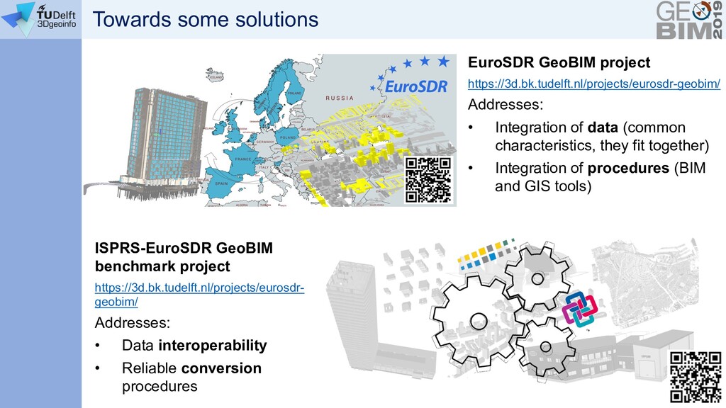
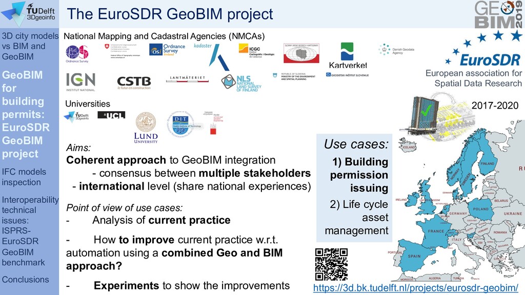
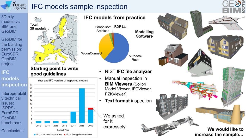
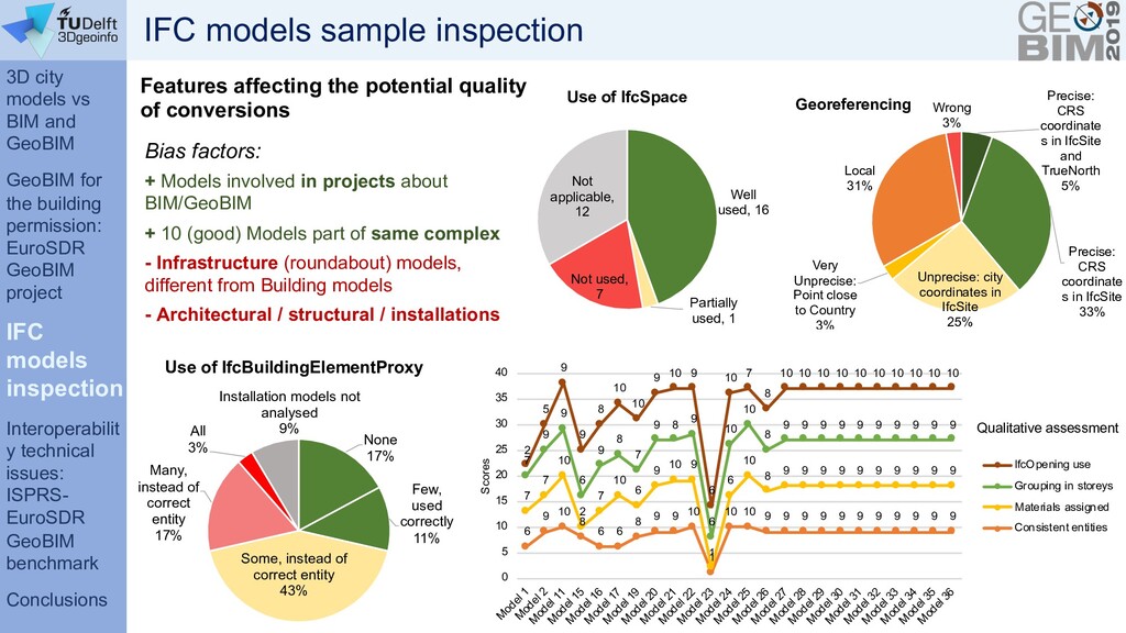
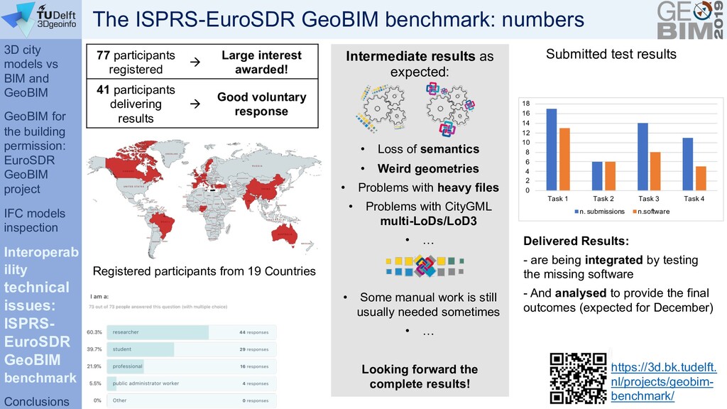
The GeoBIM problem is tackled by starting from the information necessary to support a building permit issuing use case. Moreover, the initial results are reported about the inspection of a sample of BIMs produced by practice, and finally an overview of the GeoBIM benchmark project is given.

Francesca Noardo

November 12, 2019
Tweet

More Decks by Francesca Noardo

Other Decks in Research

Transcript

  1. Towards making GeoBIM from Geo and BIM F. Noardo, K.

    Arroyo Ohori, C.Ellul, L. Harrie, J. Stoter 3D geoinformation group Delft University of Technology, NL [email protected] 12th November 2019
  2. Overview 1) Introduction: 3D city models vs BIM and GeoBIM

    2) Working towards GeoBIM for the building permission use case: the EuroSDR GeoBIM project 3) Investigating the interoperability technical issues: the ISPRS-EuroSDR GeoBIM benchmark 6) Conclusion and final remarks
  3. 3D city models vs BIM and GeoBIM GeoBIM for the

    building permits: EuroSDR GeoBIM project IFC models inspection Interoperabilit y technical issues: ISPRS- EuroSDR GeoBIM benchmark Conclusions High level of detail 3D cadaster No tasks duplication (3D data collection) Efficient databases updates without additional costs Effective data exchange with professionals (architects, engineers, environmental scientists, etc.) Stronger information for lifecycle asset management & city analysis Context for design reference Improved test of building properties: designed building into its context Test of the impact of the building on the city or landscape. Multiscale vision (from construction elements to whole territories) BIM world point of view GEO world point of view = integration of geoinformation with BIMs GeoBIM Building Information Models 3D geoinformation: 3D city models + Great advantages from integration
  4. 3D city models vs BIM and GeoBIM GeoBIM for the

    building permits: EuroSDR GeoBIM project IFC models inspection Interoperabilit y technical issues: ISPRS- EuroSDR GeoBIM benchmark Conclusions 1. Integration of data (common characteristics, they fit together) 2. Data interoperability 3. Reliable conversions BIM « GIS 4. Integration of procedures (BIM and GIS tools) GeoBIM Building Informatio n Models 3D geoinformation: 3D city models + = integration of geoinformation with BIMs …But it’s not a trivial issue
  5. EuroSDR GeoBIM project https://3d.bk.tudelft.nl/projects/eurosdr-geobim/ Addresses: • Integration of data (common

    characteristics, they fit together) • Integration of procedures (BIM and GIS tools) ISPRS-EuroSDR GeoBIM benchmark project https://3d.bk.tudelft.nl/projects/eurosdr- geobim/ Addresses: • Data interoperability • Reliable conversion procedures Towards some solutions
  6. 3D city models vs BIM and GeoBIM GeoBIM for building

    permits: EuroSDR GeoBIM project IFC models inspection Interoperability technical issues: ISPRS- EuroSDR GeoBIM benchmark Conclusions https://3d.bk.tudelft.nl/projects/eurosdr-geobim/ Aims: Coherent approach to GeoBIM integration - consensus between multiple stakeholders - international level (share national experiences) Point of view of use cases: - Analysis of current practice - How to improve current practice w.r.t. automation using a combined Geo and BIM approach? - Experiments to show the improvements National Mapping and Cadastral Agencies (NMCAs) 2017-2020 European association for Spatial Data Research Universities Use cases: 1) Building permission issuing 2) Life cycle asset management The EuroSDR GeoBIM project
  7. 3D city models vs BIM and GeoBIM GeoBIM for building

    permits: EuroSDR GeoBIM project IFC models inspection Interoperability technical issues: ISPRS- EuroSDR GeoBIM benchmark Conclusions Bottom-up approach Case study in Rotterdam (NL) Case study in Epone (F) They provide us with: • Data (IFC BIM and CityGML 3D city model) • Nice and enthusiastic people to collaborate with EuroSDR GeoBIM case studies Case studies: Ø The Netherlands (Rotterdam, Den Haag, Almere, Amsterdam) Ø France (Epone) • Data • Regulations • Practice expertise Sweden / Slovenija 1) Workflow + stakeholders 2) Regulations check 3) Guidelines to designers/3D city modelers Interviews and collaboration
  8. 3D city models vs BIM and GeoBIM GeoBIM for building

    permits: EuroSDR GeoBIM project IFC models inspection Interoperability technical issues: ISPRS- EuroSDR GeoBIM benchmark Conclusions Now With GeoBIM Asked for the submission: - 2D Drawings [PDF 2D plans and sections] - Designed building in City plan [PDF 2D map] - Report proving compliance to regulations (Building physics, Fire safety, City quality, structural safety, construction quality) [PDF document] Asked for the submission: - A BIM model compliant with the given requirements (w.r.t. geometry, semantics, georeferencing) [IFC georeferenced model] Provided by the Municipality: - 2D city map - Zoning and related regulations, WebGIS (https://www.ruimtelijkeplannen.nl) Provided by the Municipality: Standardized 3D city model (CityGML) City regulations in digital (and formal) format 1) GeoBIM Workflow proposal
  9. 3D city models vs BIM and GeoBIM GeoBIM for building

    permits: EuroSDR GeoBIM project IFC models inspection Interoperability technical issues: ISPRS- EuroSDR GeoBIM benchmark Conclusions 1) GeoBIM Workflow proposal
  10. 3D city models vs BIM and GeoBIM GeoBIM for building

    permits: EuroSDR GeoBIM project IFC models inspection Interoperability technical issues: ISPRS- EuroSDR GeoBIM benchmark Conclusions IFC Validation Regulations checks Integration of procedural + operational workflow in structured UML model Under review within Municipalities 1) GeoBIM Workflow proposal
  11. 3D city models vs BIM and GeoBIM GeoBIM for building

    permits: EuroSDR GeoBIM project IFC models inspection Interoperability technical issues: ISPRS- EuroSDR GeoBIM benchmark Conclusions 2) Regulations check: human challenges I Workshop 16/10/2019 – Building dimensions and parking spaces design in the city regulations II Workshop 05/11/2019 – External experts involved in building permission issuing (Fire safety, structural safety, City aesthetics, Building physics) Persuading operators Regulations interpretation
  12. 3D city models vs BIM and GeoBIM GeoBIM for building

    permits: EuroSDR GeoBIM project IFC models inspection Interoperability technical issues: ISPRS- EuroSDR GeoBIM benchmark Conclusions Translation to ‘formal’ language and information mapping 2) Regulations check: information challenges
  13. 3D city models vs BIM and GeoBIM GeoBIM for building

    permits: EuroSDR GeoBIM project IFC models inspection Interoperability technical issues: ISPRS- EuroSDR GeoBIM benchmark Conclusions What part of the 3D city model (CityGML) is useful? Selection of the needed classes In a useful Level of Detail Eventually with ADEs à Conversion to a proper format, if needed Depends on the regulation to be checked Clear metadata are needed! What part of the BIM is useful? Selection of the needed classes In the useful Level Of Development Export to a proper IFC Model View Definition à Conversion to a proper format, if needed Make the checks 2) Regulations check: technology challenges
  14. 3D city models vs BIM and GeoBIM GeoBIM for the

    building permission: EuroSDR GeoBIM project IFC models inspection Interoperabilit y technical issues: ISPRS- EuroSDR GeoBIM benchmark Conclusions IFC models sample inspection 24 1 1 1 9 Total: 36 models Autodesk Revit WoonConnect Graphisoft Archicad RDF Ltd. Modelling Software • NIST IFC file analyzer • Manual inspection in BIM Viewers (Solibrí Model Viewer, IFCViewer, FZKViewer) • Text format inspection We asked for it expressely 0 2 4 6 8 10 12 14 16 18 20 2012 2014 2015 2016 2017 2018 2019 Export Year Year and IFC version of inspected models IFC 2x3 CoordinationView IFC 4 DesignTransferView IFC models from practice We would like to increase the sample… Starting point to write good guidelines
  15. 3D city models vs BIM and GeoBIM GeoBIM for the

    building permission: EuroSDR GeoBIM project IFC models inspection Interoperabilit y technical issues: ISPRS- EuroSDR GeoBIM benchmark Conclusions IFC models sample inspection Features affecting the potential quality of conversions Well used, 16 Partially used, 1 Not used, 7 Not applicable, 12 Use of IfcSpace Bias factors: + Models involved in projects about BIM/GeoBIM + 10 (good) Models part of same complex - Infrastructure (roundabout) models, different from Building models - Architectural / structural / installations None 17% Few, used correctly 11% Some, instead of correct entity 43% Many, instead of correct entity 17% All 3% Installation models not analysed 9% Use of IfcBuildingElementProxy 6 9 10 8 6 6 8 9 9 10 1 10 10 9 9 9 9 9 9 9 9 9 9 9 7 7 10 2 7 10 6 9 10 9 1 6 10 8 9 9 9 9 9 9 9 9 9 9 7 9 9 6 9 8 7 9 8 9 6 10 10 8 9 9 9 9 9 9 9 9 9 9 2 5 9 9 8 10 10 9 10 9 6 10 7 8 10 10 10 10 10 10 10 10 10 10 0 5 10 15 20 25 30 35 40 M odel 1 M odel 2 M odel 11 M odel 15 M odel 16 M odel 17 M odel 19 M odel 20 M odel 21 M odel 22 M odel 23 M odel 24 M odel 25 M odel 26 M odel 27 M odel 28 M odel 29 M odel 30 M odel 31 M odel 32 M odel 33 M odel 34 M odel 35 M odel 36 Scores Qualitative assessment IfcOpening use Grouping in storeys Materials assigned Consistent entities Precise: CRS coordinate s in IfcSite and TrueNorth 5% Precise: CRS coordinate s in IfcSite 33% Unprecise: city coordinates in IfcSite 25% Very Unprecise: Point close to Country 3% Local 31% Wrong 3% Georeferencing
  16. 3D city models vs BIM and GeoBIM GeoBIM for the

    building permission: EuroSDR GeoBIM project IFC models inspection Interoperab ility technical issues: ISPRS- EuroSDR GeoBIM benchmark Conclusions Reference study on software support for open standards of city and building models The ISPRS-EuroSDR GeoBIM benchmark
  17. 3D city models vs BIM and GeoBIM GeoBIM for the

    building permission: EuroSDR GeoBIM project IFC models inspection Interoperab ility technical issues: ISPRS- EuroSDR GeoBIM benchmark Conclusions The ISPRS-EuroSDR GeoBIM benchmark Investigation of the available technical solutions to support the open standards IFC (by buildingSMART) and CityGML (by OGC). 1. What is the support for IFC within BIM (and other) software? 2. What options for geo- referencing BIM data are available? 3. What is the support for CityGML within GIS (and other) tools? 4. What options for conversion (IFC↔CityGML) are available? Tasks: External voluntary participants can perform one or more tasks with the tools they are familiar with, and deliver their results in the provided on-line results template. Aim: https://3d.bk.tudelft.nl/projects/geo bim-benchmark/ georeferencing geometry semantics Sw functionalities
  18. 3D city models vs BIM and GeoBIM GeoBIM for the

    building permission: EuroSDR GeoBIM project IFC models inspection Interoperab ility technical issues: ISPRS- EuroSDR GeoBIM benchmark Conclusions Registered participants from 19 Countries Intermediate results as expected: • Loss of semantics • Weird geometries • Problems with heavy files • Problems with CityGML multi-LoDs/LoD3 • … • Some manual work is still usually needed sometimes • … Looking forward the complete results! Submitted test results https://3d.bk.tudelft. nl/projects/geobim- benchmark/ 77 participants registered à Large interest awarded! 41 participants delivering results à Good voluntary response Delivered Results: - are being integrated by testing the missing software - And analysed to provide the final outcomes (expected for December) 0 2 4 6 8 10 12 14 16 18 Task 1 Task 2 Task 3 Task 4 n. submissions n.software The ISPRS-EuroSDR GeoBIM benchmark: numbers
  19. 3D city models vs BIM and GeoBIM GeoBIM for the

    building permission: EuroSDR GeoBIM project IFC models inspection Interoperabilit y technical issues: ISPRS- EuroSDR GeoBIM benchmark Conclusions We are tackling the GeoBIM issue considering all the involved aspects, possibly together: Image by rawpixel from Pixabay Conclusions • How the data can be harmonized and what rules they need to follow for a successful integration • What technical tools, conversions, formats and kind of implementations are needed to actually reach interoperability • How to align the current practice procedures and needs to the new opportunities given by the use of GeoBIM
  20. 3D city models vs BIM and GeoBIM GeoBIM for the

    building permission: EuroSDR GeoBIM project IFC models inspection Interoperabilit y technical issues: ISPRS- EuroSDR GeoBIM benchmark Conclusions EuroSDR/AMS-institute GeoBIM benchmark workshop December 2nd/3rd 2019 At the Amsterdam Institute for Advanced Metropolitan Solutions, Amsterdam. • Insight into GeoBIM benchmark results • 3D city models, • Building Information Models, • open standards (CityGML, CityJSON, IFC, more), • GeoBIM use cases (automatic building permission issuing, asset management, energy simulations). Registration deadline: 15th November https://3d.bk.tudelft.nl/projects/geobim-benchmark/events.html
  21. This Special Issue aims to submissions with a theoretical approach

    and more applied studies, e.g., we encourage studies about specific use cases and practical, replicable applications. Furthermore, we welcome submissions that promote the use of open standards, both by evaluating the current standards and tools in exercises such as benchmarking and by proposing extensions/improvements to the current open standards., including but not limited to: Special Issue Integration of BIM and GIS for Built Environment Applications Special Issue Editors: Prof. Dr. Lars Harrie: Lund University, Sweden Dr. Francesca Noardo: Delft University of Technology, the Netherlands Dr. Claire Ellul: University College London, UK https://www.mdpi.com/journal/ijgi/special_issues/BIM_GIS_built IMPACT FACTOR 1.840 MDPI St. Alban-Anlage 66 CH-4052 Basel Switzerland Tel: +41 61 683 77 34 Fax: +41 61 302 89 18 Academic Open Access Publishing Since 1996 • Case studies highlighting the potential of BIM/GIS integration; • BIM data used for maintaining and improving geodatabases; • Use of geodata in BIM; • Data models for BIM–GIS integration; • Spatial data analyses using BIM–GIS integration; • Improvements/extensions to open city model standards to facilitate BIM integration; • Improvements/extensions to open BIM standards to facilitate geospatial integration; • BIM georeferencing; • Versioning of integrated BIM–GIS data; • Smart city applications based on BIM and GIS data; • Open source tools for BIM–GIS integration; • 4D – the importance of time in BIM–GIS integration. (Submission Deadline: 29 February 2020) (ISSN 2220-9964) |1.84 Impact Factor |50days Article Processing Time |18days Submission to Frist Decision |5days Acceptance to publication