Upgrade to Pro — share decks privately, control downloads, hide ads and more …

GeoBIM integration in practice

Francesca Noardo
September 24, 2019

GeoBIM integration in practice

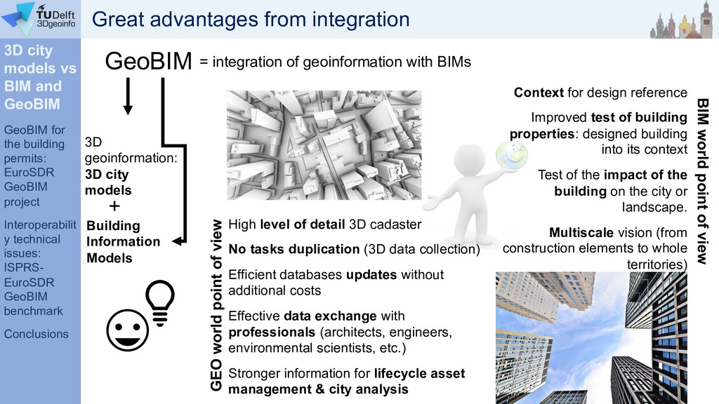
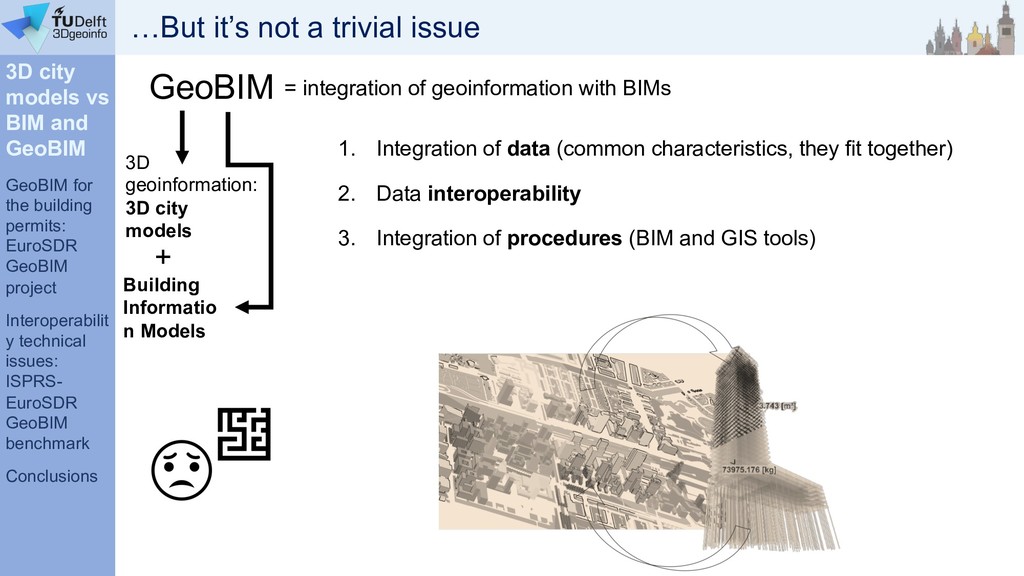
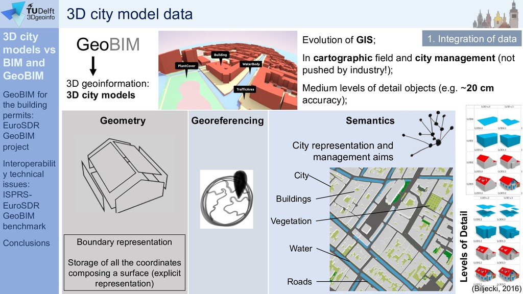
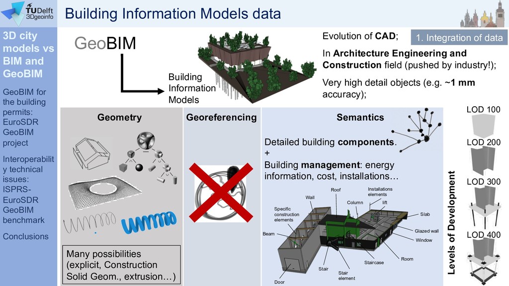
1) Insight into 3D city models and Building information models (BIM) and chances and challenges to integrate them into GeoBIM.
- Data
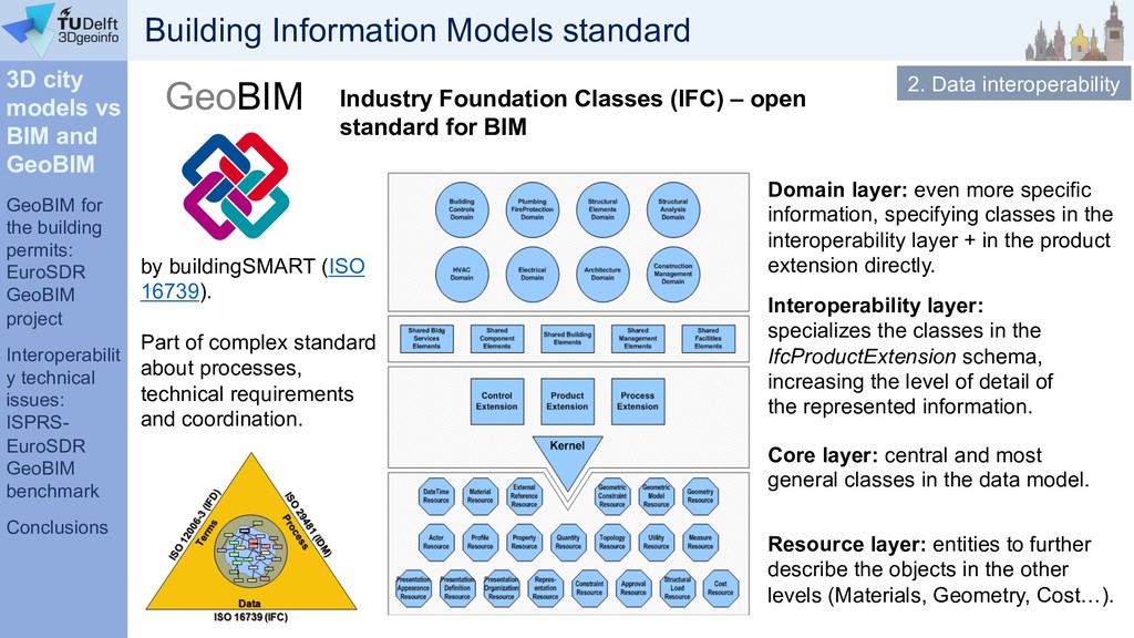
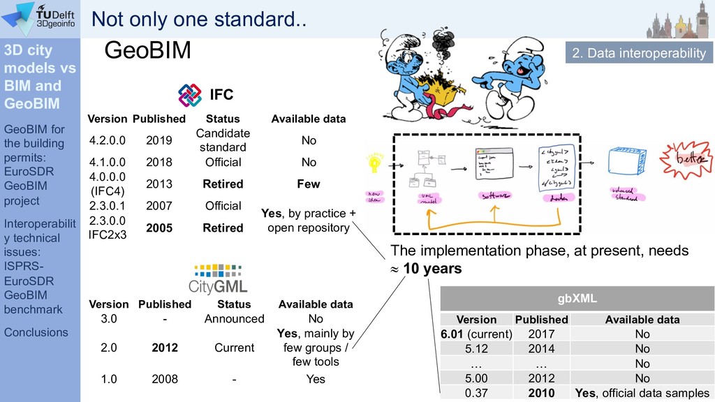
- Standard data models: CityGML and Industry Foundation Classes
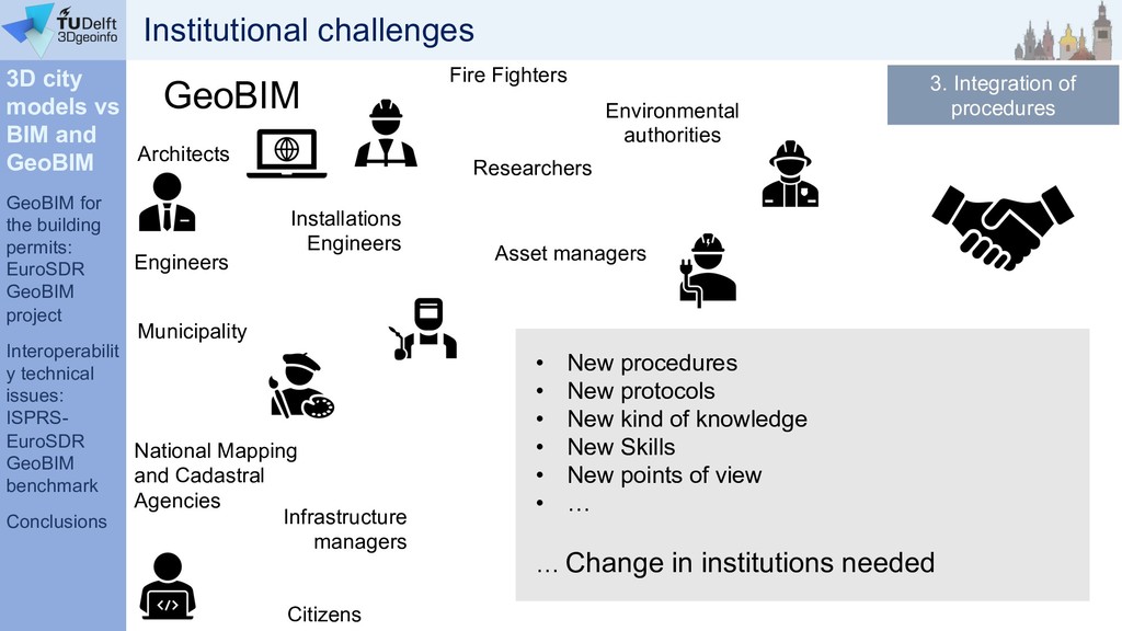
- Non technical issues.

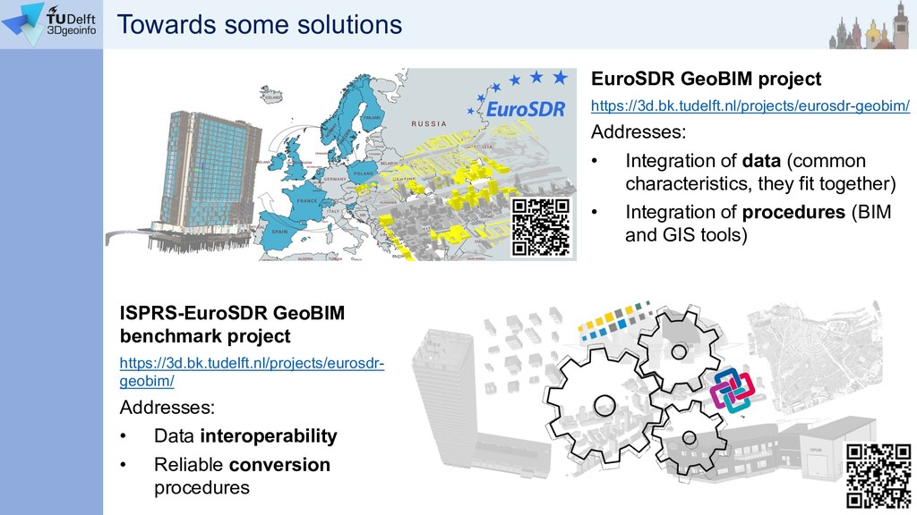
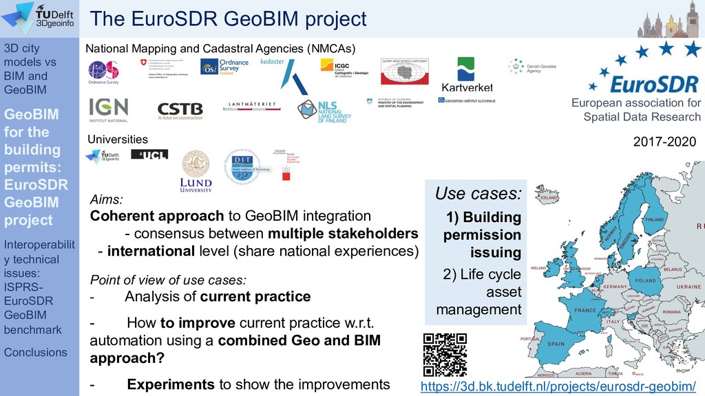
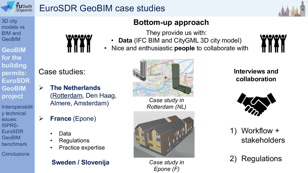
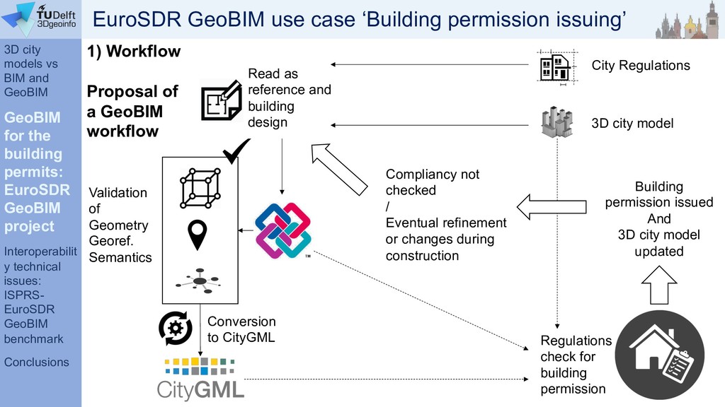
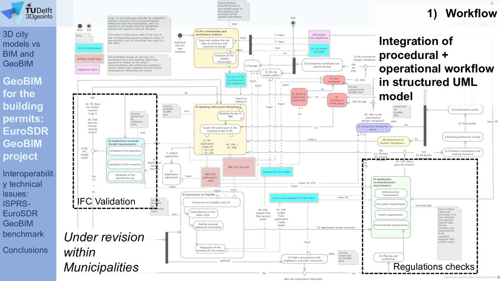
2) How to address the challenges for the building permission use case in the EuroSDR GeoBIM project.

3) Investigating the interoperability technical issues in the ISPRS-EuroSDR GeoBIM benchmark.

Francesca Noardo

September 24, 2019
Tweet

More Decks by Francesca Noardo

Other Decks in Research

Transcript

  1. GeoBIM integration in practice: from design to automatic building permission

    issuing Francesca Noardo [email protected] Delft University of Technology (3D geoinformation group) 24th September 2019
  2. Overview 1) Introduction: 3D city models vs BIM and GeoBIM

    • General issues • Related open standards: CityGML and Industry Foundation Classes • Non technical issues 2) Working towards GeoBIM for the building permission use case the EuroSDR GeoBIM project 3) Investigating the interoperability technical issues the ISPRS-EuroSDR GeoBIM benchmark 4) Conclusion and final remarks
  3. 3D city models vs BIM and GeoBIM GeoBIM for the

    building permits: EuroSDR GeoBIM project Interoperabilit y technical issues: ISPRS- EuroSDR GeoBIM benchmark Conclusions GeoBIM 3D geoinformation: 3D city models X solar potential shadow analysis noise modelling energy estimation bomb detonation wind turbulence pollutant tracking Navigation Flood simulations Multivariate analysis 3D cadastre 3D archive Multitemporal analysis Risk assessment… 3D city models use cases
  4. 3D city models vs BIM and GeoBIM GeoBIM for the

    building permits: EuroSDR GeoBIM project Interoperabilit y technical issues: ISPRS- EuroSDR GeoBIM benchmark Conclusions GeoBIM • design options assessment; • quantities and cost estimation; • construction simulation; • energy modelling; • project management support (efficient collaboration, multi-disciplinary project team); • facilities and asset management; • better design and construction coordination; • reduced construction costs (less delays on-site, rework…) • reduced operational costs (seamless information delivery for facilities management at handover). Building Information Models Building Information Models use cases
  5. 3D city models vs BIM and GeoBIM GeoBIM for the

    building permits: EuroSDR GeoBIM project Interoperabilit y technical issues: ISPRS- EuroSDR GeoBIM benchmark Conclusions GeoBIM 3D geoinformation: 3D city models Difficult to update (new building, building changes…) Missing detailed building information (materials, energy related information…) Difficulties in modelling large numbers of high level of detail buildings Rotterdam 3D city models miss something
  6. 3D city models vs BIM and GeoBIM GeoBIM for the

    building permits: EuroSDR GeoBIM project Interoperabilit y technical issues: ISPRS- EuroSDR GeoBIM benchmark Conclusions GeoBIM Building Information Models No context (transport networks, environmental features, urban values, infrastructure connections…) Somewhere in the world (only generic location information, with very low accuracy…) Discrepancy between the precision of what is modelled in the BIM and the context where it is supposed to be built (possible need to fix them on site, during construction) Building Information Models miss something
  7. 3D city models vs BIM and GeoBIM GeoBIM for the

    building permits: EuroSDR GeoBIM project Interoperabilit y technical issues: ISPRS- EuroSDR GeoBIM benchmark Conclusions High level of detail 3D cadaster No tasks duplication (3D data collection) Efficient databases updates without additional costs Effective data exchange with professionals (architects, engineers, environmental scientists, etc.) Stronger information for lifecycle asset management & city analysis Context for design reference Improved test of building properties: designed building into its context Test of the impact of the building on the city or landscape. Multiscale vision (from construction elements to whole territories) BIM world point of view GEO world point of view = integration of geoinformation with BIMs GeoBIM Building Information Models 3D geoinformation: 3D city models + Great advantages from integration
  8. 3D city models vs BIM and GeoBIM GeoBIM for the

    building permits: EuroSDR GeoBIM project Interoperabilit y technical issues: ISPRS- EuroSDR GeoBIM benchmark Conclusions 1. Integration of data (common characteristics, they fit together) 2. Data interoperability 3. Integration of procedures (BIM and GIS tools) GeoBIM Building Informatio n Models 3D geoinformation: 3D city models + = integration of geoinformation with BIMs …But it’s not a trivial issue
  9. 3D city models vs BIM and GeoBIM GeoBIM for the

    building permits: EuroSDR GeoBIM project Interoperabilit y technical issues: ISPRS- EuroSDR GeoBIM benchmark Conclusions GeoBIM 3D geoinformation: 3D city models Evolution of GIS; In cartographic field and city management (not pushed by industry!); Medium levels of detail objects (e.g. ~20 cm accuracy); Boundary representation Storage of all the coordinates composing a surface (explicit representation) Geometry Semantics City representation and management aims Georeferencing Buildings Vegetation Roads Water City (Biljecki, 2016) Levels of Detail 1. Integration of data 3D city model data
  10. 3D city models vs BIM and GeoBIM GeoBIM for the

    building permits: EuroSDR GeoBIM project Interoperabilit y technical issues: ISPRS- EuroSDR GeoBIM benchmark Conclusions GeoBIM Building Information Models Geometry Semantics Georeferencing Levels of Development Many possibilities (explicit, Construction Solid Geom., extrusion…) Detailed building components. + Building management: energy information, cost, installations… Specific construction elements Beam lift Window Staircase Door Stair element Stair Slab Room Glazed wall Roof Installations elements Column Wall LOD 100 LOD 200 LOD 400 LOD 300 Evolution of CAD; In Architecture Engineering and Construction field (pushed by industry!); Very high detail objects (e.g. ~1 mm accuracy); 1. Integration of data Building Information Models data
  11. 3D city models vs BIM and GeoBIM GeoBIM for the

    building permits: EuroSDR GeoBIM project Interoperabilit y technical issues: ISPRS- EuroSDR GeoBIM benchmark Conclusions by Open Geospatial Consortium (OGC) 2. Data interoperability GeoBIM Possibility to extend the model with application- related classes and attributes: CityGML Application Domain Extensions (ADEs) (Noise ADE, Energy ADE, Utility Network ADE…) Core model: central and most general classes in the data model. Modules: data model specification for each category of city objects (Buildings, Vegetation, Transport network, Water…). CityGML – open standard for 3D city models 3D city models standard
  12. 3D city models vs BIM and GeoBIM GeoBIM for the

    building permits: EuroSDR GeoBIM project Interoperabilit y technical issues: ISPRS- EuroSDR GeoBIM benchmark Conclusions Intended to cover the most basic 3D city information with meaningful “object-oriented” representation. Intended as open format + human-readable à information won’t be lost even when losing backwards-compatibility. We can love CityGML because: Standardised mechanism to extend the model following the needs of specific domains: Application Domain Extensions (ADEs) à Customised information can be modelled, through a known procedure. GeoBIM Multiscale representation! 2. Data interoperability 3D city models standard (img by Biljecki, 2016)
  13. 3D city models vs BIM and GeoBIM GeoBIM for the

    building permits: EuroSDR GeoBIM project Interoperabilit y technical issues: ISPRS- EuroSDR GeoBIM benchmark Conclusions If you are a software developer: Development process of the model not always very transparent and open (although recent changes in working methods) CityGML can potentially disappoint because: GeoBIM Image by by talin401 imgur.com 17/1/2018 2. Data interoperability 3D city models standard http://erouault.blogspot.com/2014/04/ gml-madness.html Geography Markup Language (GML) to store geometry: many issues. E.g. a polygon can be stored in 25 ways (implementation must support all of them!) Complex data model and weird possible connections to internal/external information can give implementation problems: LESS IS MORE
  14. 3D city models vs BIM and GeoBIM GeoBIM for the

    building permits: EuroSDR GeoBIM project Interoperabilit y technical issues: ISPRS- EuroSDR GeoBIM benchmark Conclusions RESULT: If you are a user: CityGML can potentially disappoint because: Anyway, we trust it is possible to work towards the good side of CityGML! GeoBIM https://www.cityjson.org Very few software support the correct and complete import, view, edit and analysis.. The richness is lost + no user-friendly tools to manage data. à Great, powerful use of such data is prevented The data are computationally very heavy à Use of such data is prevented Metadata are not systematically associated to data à Reuse of such data is prevented No clear coded rules about how to store information (e.g. Levels of Details) à Reuse of such data is prevented Different ADEs can exist for the same domain, and can have differences à Reuse of such data is prevented 2. Data interoperability 3D city models standard
  15. 3D city models vs BIM and GeoBIM GeoBIM for the

    building permits: EuroSDR GeoBIM project Interoperabilit y technical issues: ISPRS- EuroSDR GeoBIM benchmark Conclusions Industry Foundation Classes (IFC) – open standard for BIM 2. Data interoperability GeoBIM Core layer: central and most general classes in the data model. Interoperability layer: specializes the classes in the IfcProductExtension schema, increasing the level of detail of the represented information. Resource layer: entities to further describe the objects in the other levels (Materials, Geometry, Cost…). Domain layer: even more specific information, specifying classes in the interoperability layer + in the product extension directly. by buildingSMART (ISO 16739). Part of complex standard about processes, technical requirements and coordination. Building Information Models standard
  16. 3D city models vs BIM and GeoBIM GeoBIM for the

    building permits: EuroSDR GeoBIM project Interoperabilit y technical issues: ISPRS- EuroSDR GeoBIM benchmark Conclusions Inclusive full domain data model: interoperable information for any building use case *one common language* Intended as open format + human-readable à information won’t be lost even when losing backwards-compatibility. We can love IFC because: Standardised mechanism to extract application data models to structure use-case specific information: Information Delivery Manual (IDM) + Model View Definition (MVD) à Only needed information used, and effectively. Even very different information is interoperable: refer to the same domain description. GeoBIM 2. Data interoperability Building Information Models standard
  17. 3D city models vs BIM and GeoBIM GeoBIM for the

    building permits: EuroSDR GeoBIM project Interoperabilit y technical issues: ISPRS- EuroSDR GeoBIM benchmark Conclusions Its ‘openness’ sometimes is hampered: • to find simple explanations about the model, (how is it conceived, structured and used) can be tricky; • the work-in-progress for schemas and MVDs cannot be accessed (e.g. draft of “Energy Analysis View” cannot be seen); • certification procedure and criteria are not openly accessible (only general information, no reference data nor access to the procedure) GeoBIM IFC can potentially disappoint because: • Maybe too affected by ‘company approach’: great efficiency and adoption, but high certification costs, dense new-release schedule • ISO standard: has to be bought 2. Data interoperability Building Information Models standard
  18. 3D city models vs BIM and GeoBIM GeoBIM for the

    building permits: EuroSDR GeoBIM project Interoperabilit y technical issues: ISPRS- EuroSDR GeoBIM benchmark Conclusions Only export to Model View Definitions (MVDs) (no fully inclusive IFC model generated by software) Customised MVDs are seldom supported by software à only official MVDs can be used. RESULT: proprietary formats used as inclusive ‘domain ontology’, and export formats (e.g. IFC MVDs, gbXML for energy, etc.) are the used subsets of the model information. à IFC not used as inclusive domain data model supporting interoperability; MVDs used as ‘operational’ formats; à However, IFC MVDs are not often fully supported as operational formats in many tools (YET) GeoBIM IFC can potentially disappoint because: Anyway, we trust it is possible to work towards the good side of IFC! Image by Gerd Altmann, Pixabay 2. Data interoperability Building Information Models standard
  19. 3D city models vs BIM and GeoBIM GeoBIM for the

    building permits: EuroSDR GeoBIM project Interoperabilit y technical issues: ISPRS- EuroSDR GeoBIM benchmark Conclusions Version Published Status 3.0 - Announced 2.0 2012 Official 1.0 2008 Retired? IFC Version Published Status 4.2.0.0 2019 Candidate standard 4.1.0.0 2018 Official 4.0.0.0 (IFC4) 2013 Retired 2.3.0.1 2007 Official 2.3.0.0 IFC2x3 2005 Retired Every 1-5 years a new version is released! IFC Timeline GeoBIM 2. Data interoperability Not only one standard..
  20. 3D city models vs BIM and GeoBIM GeoBIM for the

    building permits: EuroSDR GeoBIM project Interoperabilit y technical issues: ISPRS- EuroSDR GeoBIM benchmark Conclusions gbXML Version Published Available data 6.01 (current) 2017 No 5.12 2014 No … … No 5.00 2012 No 0.37 2010 Yes, official data samples Version Published Status Available data 3.0 - Announced No 2.0 2012 Current Yes, mainly by few groups / few tools 1.0 2008 - Yes IFC Version Published Status Available data 4.2.0.0 2019 Candidate standard No 4.1.0.0 2018 Official No 4.0.0.0 (IFC4) 2013 Retired Few 2.3.0.1 2007 Official Yes, by practice + open repository 2.3.0.0 IFC2x3 2005 Retired The implementation phase, at present, needs » 10 years GeoBIM 2. Data interoperability Not only one standard..
  21. 3D city models vs BIM and GeoBIM GeoBIM for the

    building permits: EuroSDR GeoBIM project Interoperabilit y technical issues: ISPRS- EuroSDR GeoBIM benchmark Conclusions 3. Integration of procedures Architects Engineers Municipality National Mapping and Cadastral Agencies Environmental authorities Fire Fighters Installations Engineers Infrastructure managers Asset managers Citizens Researchers GeoBIM Institutional challenges • New procedures • New protocols • New kind of knowledge • New Skills • New points of view • … … Change in institutions needed
  22. 3D city models vs BIM and GeoBIM GeoBIM for the

    building permits: EuroSDR GeoBIM project Interoperabilit y technical issues: ISPRS- EuroSDR GeoBIM benchmark Conclusions • Need to harmonise the different features of 3D city models and BIMs w.r.t. Geometry & Semantics • Need to provide georeferencing for BIMs Conclusion 1: State of art challenges Image by Elias Sch. from Pixabay • Need to align open standard development with implementation and use by the community, in terms of use cases support, implementation feasibility, data production, non-expert users needs and requirements (e.g. user- friendliness) • Need of institutional changes, new skills and new agreements
  23. EuroSDR GeoBIM project https://3d.bk.tudelft.nl/projects/eurosdr-geobim/ Addresses: • Integration of data (common

    characteristics, they fit together) • Integration of procedures (BIM and GIS tools) ISPRS-EuroSDR GeoBIM benchmark project https://3d.bk.tudelft.nl/projects/eurosdr- geobim/ Addresses: • Data interoperability • Reliable conversion procedures Towards some solutions
  24. 3D city models vs BIM and GeoBIM GeoBIM for the

    building permits: EuroSDR GeoBIM project Interoperabilit y technical issues: ISPRS- EuroSDR GeoBIM benchmark Conclusions https://3d.bk.tudelft.nl/projects/eurosdr-geobim/ Aims: Coherent approach to GeoBIM integration - consensus between multiple stakeholders - international level (share national experiences) Point of view of use cases: - Analysis of current practice - How to improve current practice w.r.t. automation using a combined Geo and BIM approach? - Experiments to show the improvements National Mapping and Cadastral Agencies (NMCAs) 2017-2020 European association for Spatial Data Research Universities Use cases: 1) Building permission issuing 2) Life cycle asset management The EuroSDR GeoBIM project
  25. 3D city models vs BIM and GeoBIM GeoBIM for the

    building permits: EuroSDR GeoBIM project Interoperabilit y technical issues: ISPRS- EuroSDR GeoBIM benchmark Conclusions Use case 1 From global design to building permission issuing EuroSDR GeoBIM use case ‘Building permission issuing’
  26. 3D city models vs BIM and GeoBIM GeoBIM for the

    building permits: EuroSDR GeoBIM project Interoperabilit y technical issues: ISPRS- EuroSDR GeoBIM benchmark Conclusions Bottom-up approach Case study in Rotterdam (NL) Case study in Epone (F) They provide us with: • Data (IFC BIM and CityGML 3D city model) • Nice and enthusiastic people to collaborate with EuroSDR GeoBIM case studies Case studies: Ø The Netherlands (Rotterdam, Den Haag, Almere, Amsterdam) Ø France (Epone) • Data • Regulations • Practice expertise Sweden / Slovenija 1) Workflow + stakeholders 2) Regulations Interviews and collaboration
  27. 3D city models vs BIM and GeoBIM GeoBIM for the

    building permits: EuroSDR GeoBIM project Interoperabilit y technical issues: ISPRS- EuroSDR GeoBIM benchmark Conclusions City Regulations 3D city model Read as reference and building design Validation of Geometry Georef. Semantics Conversion to CityGML Regulations check for building permission Building permission issued And 3D city model updated Compliancy not checked / Eventual refinement or changes during construction 1) Workflow Proposal of a GeoBIM workflow EuroSDR GeoBIM use case ‘Building permission issuing’
  28. 3D city models vs BIM and GeoBIM GeoBIM for the

    building permits: EuroSDR GeoBIM project Interoperabilit y technical issues: ISPRS- EuroSDR GeoBIM benchmark Conclusions IFC Validation Regulations checks 1) Workflow Integration of procedural + operational workflow in structured UML model Under revision within Municipalities
  29. 3D city models vs BIM and GeoBIM GeoBIM for the

    building permits: EuroSDR GeoBIM project Interoperabilit y technical issues: ISPRS- EuroSDR GeoBIM benchmark Conclusions Regulations most effectively checked through GeoBIM Zoning and dimensions: max height, volume, densification, distances (overhanging objects, balconies), pipe heights (restaurants). Function and zoning plan Impact of the building in environment and of environment on the building: shadows analysis, noise analysis, air quality, energy. Accessibility of the buildings in higher detail: disabled accessibility and usability, and escape routes planning. Structural safety in specific cases (e.g. Amsterdam cellars) Parking availability and plans connected to the new buildings EuroSDR GeoBIM use case ‘Building permission issuing’
  30. 3D city models vs BIM and GeoBIM GeoBIM for the

    building permits: EuroSDR GeoBIM project Interoperabilit y technical issues: ISPRS- EuroSDR GeoBIM benchmark Conclusions Regulations most effectively checked through GeoBIM: Interpretation issue is being tackled with the help by the nice, enthusiastic people in the Municipalities EuroSDR GeoBIM use case ‘Building permission issuing’
  31. 3D city models vs BIM and GeoBIM GeoBIM for the

    building permits: EuroSDR GeoBIM project Interoperabilit y technical issues: ISPRS- EuroSDR GeoBIM benchmark Conclusions What part of the 3D city model (CityGML) is useful? Selection of the needed classes In a useful Level of Detail Eventually with ADEs à Conversion to a proper format, if needed Depends on the regulation to be checked Clear metadata are needed! What part of the BIM is useful? Selection of the needed classes In the useful Level Of Development Export to a proper IFC Model View Definition à Conversion to a proper format, if needed Make the checks EuroSDR GeoBIM use case ‘Building permission issuing’
  32. 3D city models vs BIM and GeoBIM GeoBIM for the

    building permits: EuroSDR GeoBIM project Interoperabilit y technical issues: ISPRS- EuroSDR GeoBIM benchmark Conclusions • Not straightforward process (data issue, regulation issue, technical issue…) • Specific development are needed in a complex workflow; • Consensus by Municipalities on the proposed workflow Conclusion 2: Towards automatic building permission
  33. 3D city models vs BIM and GeoBIM GeoBIM for the

    building permission: EuroSDR GeoBIM project Interoperab ility technical issues: ISPRS- EuroSDR GeoBIM benchmark Conclusions The ISPRS-EuroSDR GeoBIM benchmark Investigation of the available technical solutions to support the open standards IFC (by buildingSMART) and CityGML (by OGC). 1. What is the support for IFC within BIM (and other) software? 2. What options for geo- referencing BIM data are available? 3. What is the support for CityGML within GIS (and other) tools? 4. What options for conversion (IFC↔CityGML) are available? Tasks: External voluntary participants can perform one or more tasks with the tools they are familiar with, and deliver their results in the provided on-line results template. Aim: https://3d.bk.tudelft.nl/projects/geo bim-benchmark/ georeferencing geometry semantics Sw functionalities
  34. 3D city models vs BIM and GeoBIM GeoBIM for the

    building permission: EuroSDR GeoBIM project Interoperab ility technical issues: ISPRS- EuroSDR GeoBIM benchmark Conclusions Registered participants from 19 Countries Large interest has been awarded! 31st October Conclusions 3: Initial GeoBIM benchmark outcomes Intermediate results as expected: • Problems with multi-LoDs. • Loss of semantics • Weird geometries… Looking forward the complete results! Submitted test results https://3d.bk.tudelft. nl/projects/geobim- benchmark/
  35. 3D city models vs BIM and GeoBIM GeoBIM for the

    building permission: EuroSDR GeoBIM project Interoperabilit y technical issues: ISPRS- EuroSDR GeoBIM benchmark Conclusions No packed solutions yet, but: • Wide interest from both academy and stakeholders points of view • The GeoBIM topic has now clear specific issues to be addressed • Continuous exchange and collaboration between researchers, stakeholders, software implementers and standardization institutions is essential to overcome those issues Image by rawpixel from Pixabay Conclusions
  36. 3D city models vs BIM and GeoBIM GeoBIM for the

    building permission: EuroSDR GeoBIM project Interoperabilit y technical issues: ISPRS- EuroSDR GeoBIM benchmark Conclusions EuroSDR-AMS GeoBIM benchmark workshop December 2nd/3rd 2019 At the Amsterdam Institute for Advanced Metropolitan Solutions, in Amsterdam, Insight into GeoBIM benchmark results Related topics: •3D city models, •Building Information Models, •open standards (CityGML, CityJSON, IFC, and more), •GeoBIM use cases (automatic building permission issuing, asset management, energy simulations). https://3d.bk.tudelft.nl/projects/geobim-benchmark/events.html
  37. GeoBIM benchmark 2019 Open special issues: Integration of BIM and

    GIS for Built Environmental Applications International Journal of Geo-Information Deadline: 29/02/2020 BIM and HBIM. Standardisation and interoperability Journal of Applied Science Deadline: 31/12/2019 Thank you for your attention, Enjoy the conference! Francesca Noardo [email protected] GeoBIM Workshop 2-3 December 2019, Amsterdam