Upgrade to Pro — share decks privately, control downloads, hide ads and more …

A Cook’s Tour of Open Data from a User’s Perspective (Instructional Development and Achievement)

A Cook’s Tour of Open Data from a User’s Perspective (Instructional Development and Achievement)

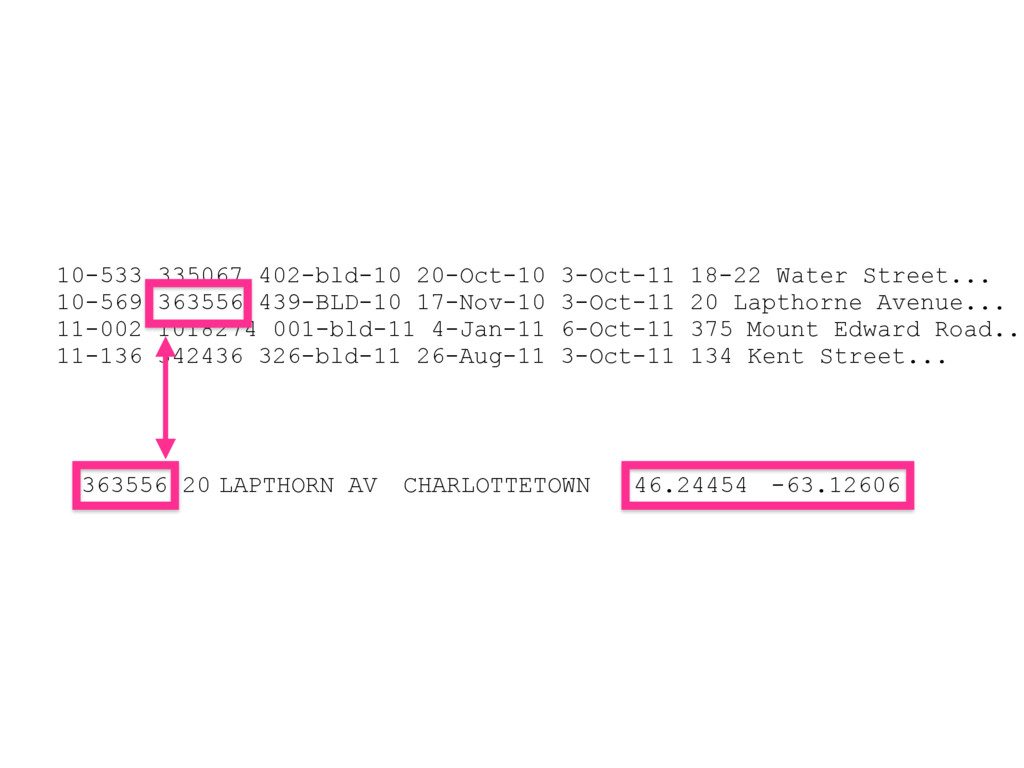
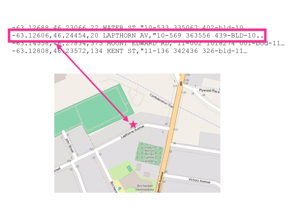
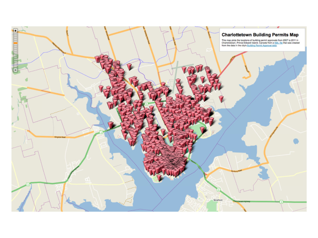
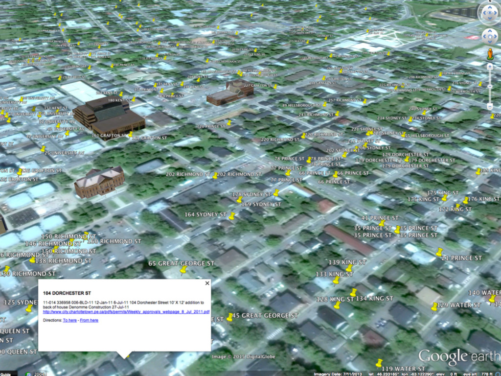
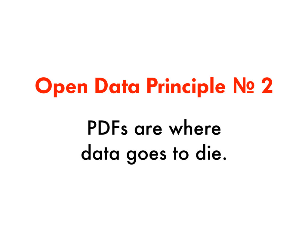
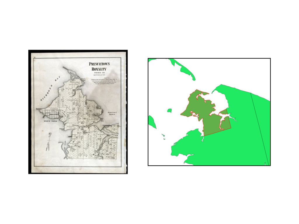
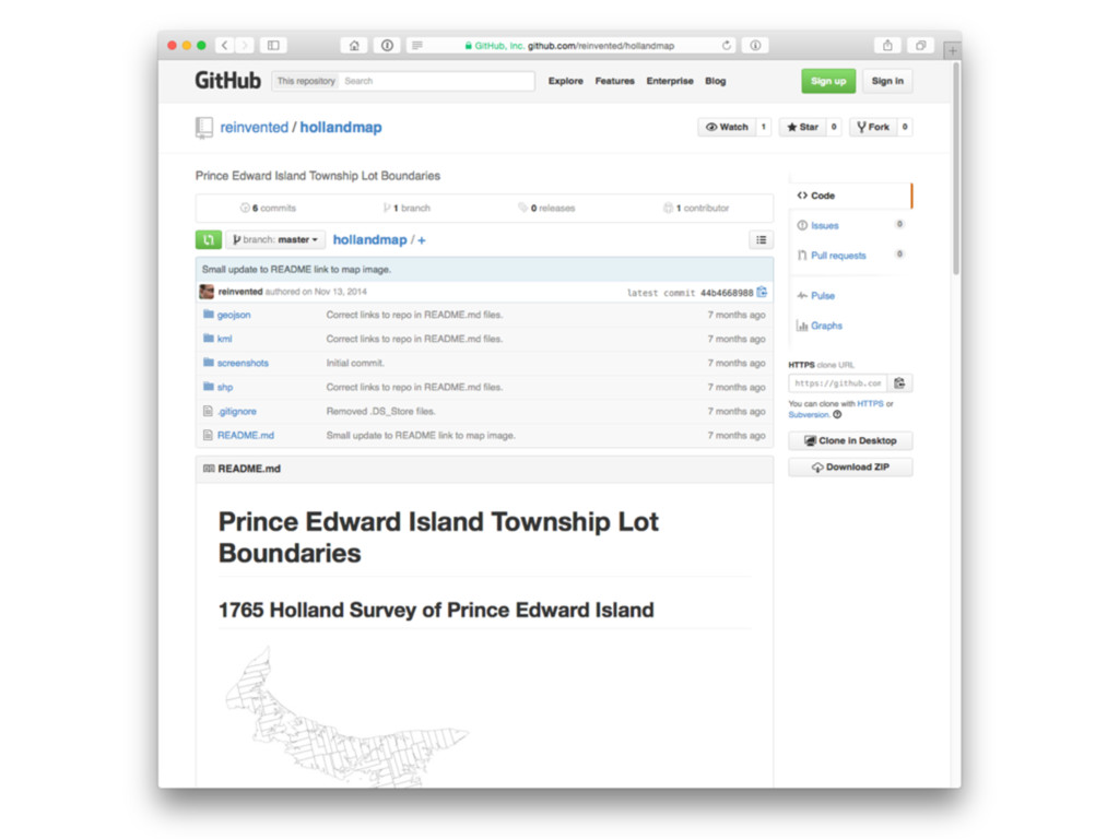
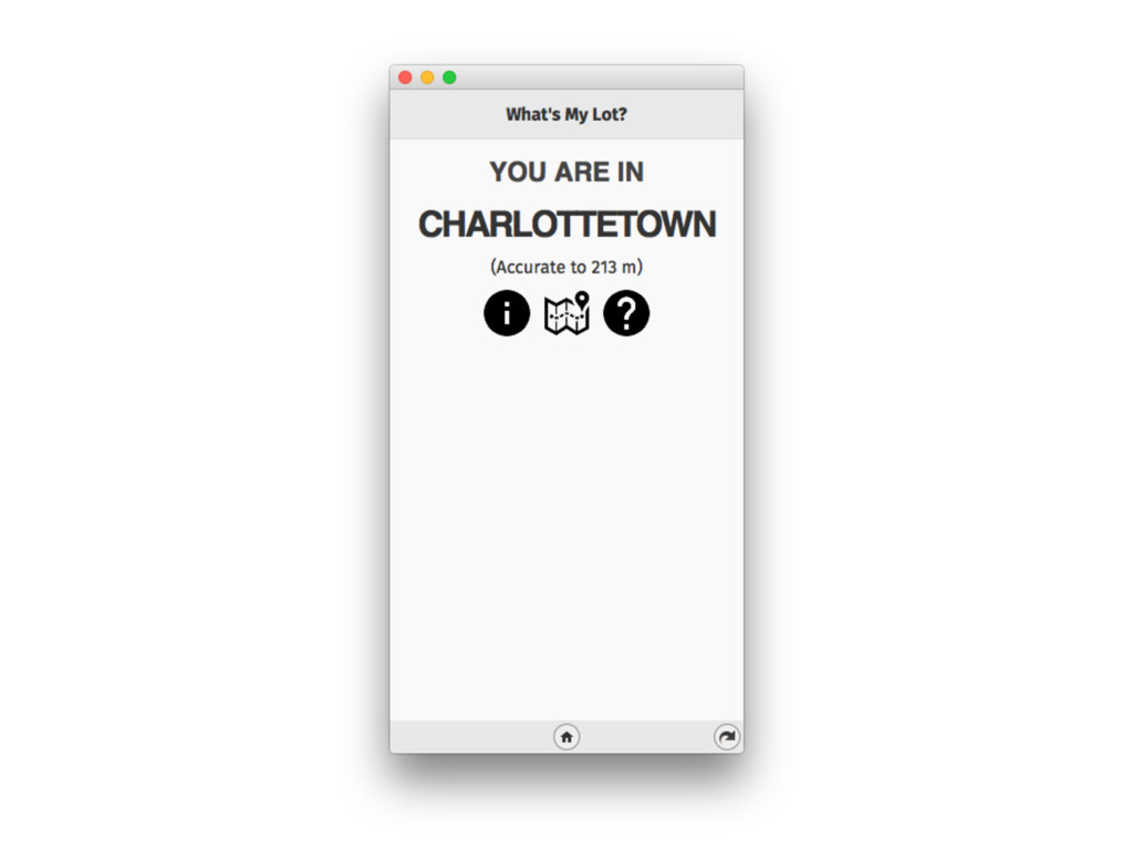
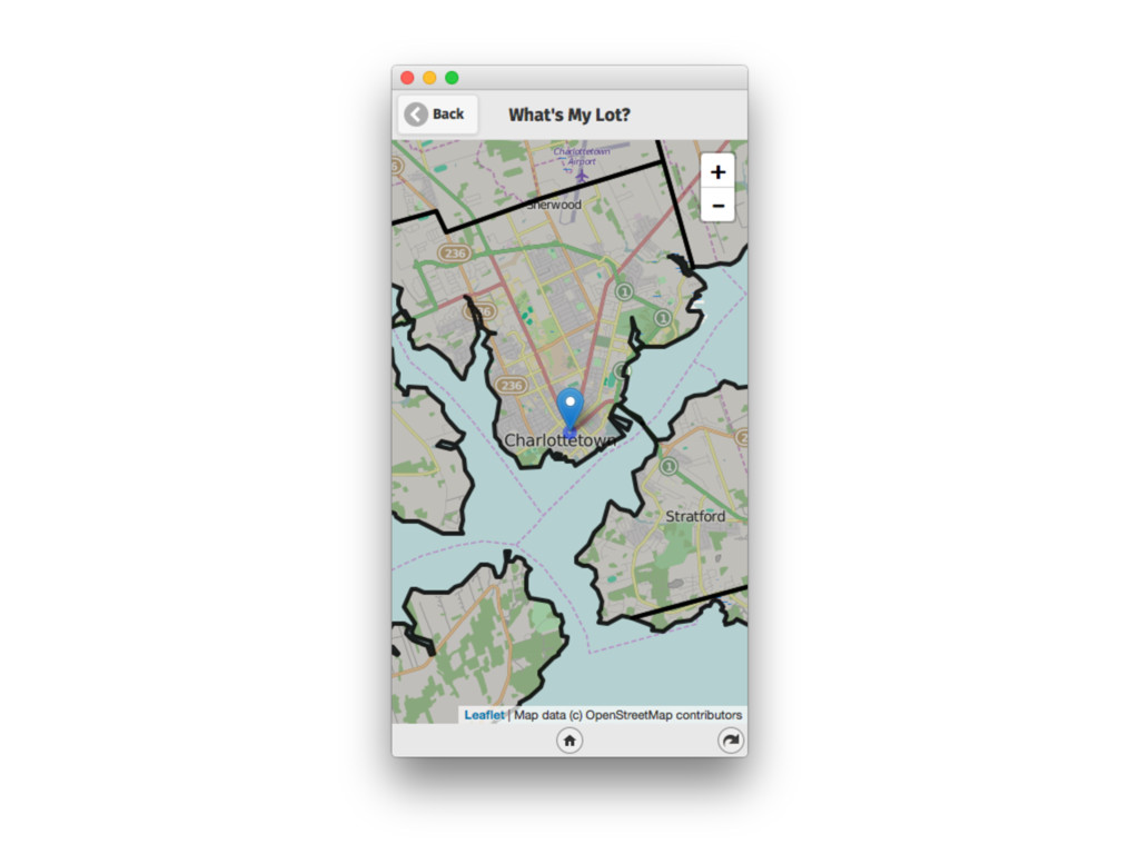
Presentation to the Instructional Development and Achievement section of the Prince Edward Island Department of Education, Early Learning and Culture on January 18, 2016, looking at open data not from a policy or regulatory perspective, but through the eyes of someone who has been consuming open data, and pointing to general principles that have been learned along the way.
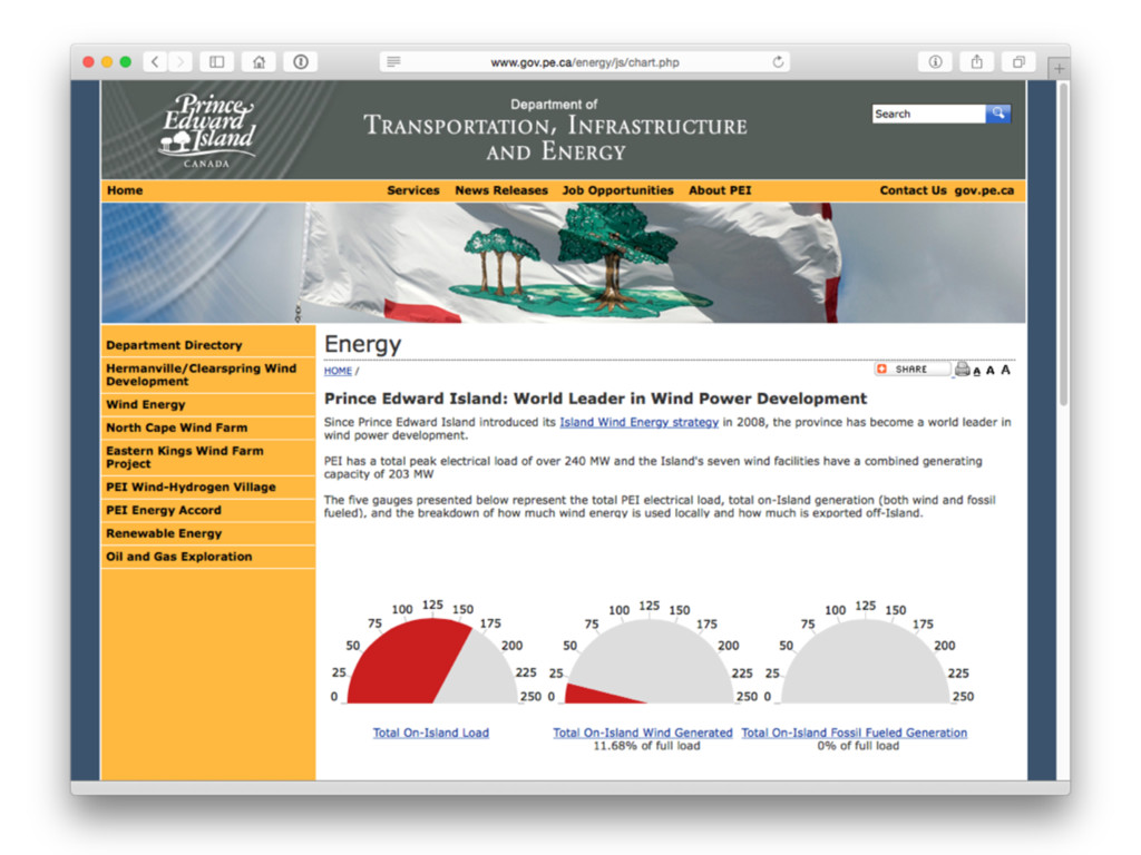
Peter Rukavina

January 18, 2016
Tweet

More Decks by Peter Rukavina

Other Decks in Education

Transcript

  1. A Cook’s Tour of Open Data
    from a User’s Perspective
    Presentation to 

    Instructional Development and Achievement
    Peter Rukavina, Hacker in Residence, Robertson Library, University of PEI
    January 18, 2016
    http://hacker.vre.upei.ca/

    View Slide

  2. Open Data Principles
    (from a user’s perspective)

    View Slide

  3. Windmill by Stephen Downes is licensed under CC BY-NC 2.0

    View Slide

  4. Photo of Richard Brown from Liberal Party of Prince Edward Island

    View Slide

  5. Photo of Ron Estabrooks taken at the open house to officially launch the Hermanville/Clearspring wind development from www.gov.pe.ca.

    View Slide

  6. View Slide

  7. View Slide

  8. View Slide

  9. Golf at 50BPM by user707748013
    50 MW
    50 BPM

    View Slide

  10. W&W - Bigfoot (Uriel M Deephouse Remix) by urielm
    122 MW
    122 BPM

    View Slide

  11. Clip of audio from CBC Spark interview with Peter Rukavina by Nora Young, recorded June 19, 2011.

    View Slide

  12. View Slide

  13. [
    {
    "data1":164.2,
    "data2":17.63,
    "data3":0,
    "updateDate":1437139741,
    "error":0
    }
    ]

    View Slide

  14. [
    {
    "on-island-load":164.2,
    "on-island-wind":17.63,
    "on-island-fossil":0,
    "updateDate":1437139741,
    "error":0
    }
    ]

    View Slide

  15. View Slide

  16. View Slide

  17. 155% of our electricity
    load from the wind
    10:30 p.m. 7:30 a.m.
    8 Hours with wind at more
    than 100% of load
    }

    View Slide

  18. View Slide

  19. View Slide

  20. View Slide

  21. View Slide

  22. Open Data Principle № 1
    You have no idea (at all)
    what open data might be
    used for.

    View Slide

  23. View Slide

  24. View Slide

  25. View Slide

  26. View Slide

  27. pdftotext -raw

    Weekly_approvals_webpage_21_Oct_2011.pdf \
    Weekly_approvals_webpage_21_Oct_2011.txt

    View Slide

  28. 10-533 335067 402-bld-10 20-Oct-10 3-Oct-11 18-22 Water Street...
    10-569 363556 439-BLD-10 17-Nov-10 3-Oct-11 20 Lapthorne Avenue...
    11-002 1018274 001-bld-11 4-Jan-11 6-Oct-11 375 Mount Edward Road...
    11-136 342436 326-bld-11 26-Aug-11 3-Oct-11 134 Kent Street...

    View Slide

  29. 10-533 335067 402-bld-10 20-Oct-10 3-Oct-11 18-22 Water Street...
    10-569 363556 439-BLD-10 17-Nov-10 3-Oct-11 20 Lapthorne Avenue...
    11-002 1018274 001-bld-11 4-Jan-11 6-Oct-11 375 Mount Edward Road...
    11-136 342436 326-bld-11 26-Aug-11 3-Oct-11 134 Kent Street...
    363556 20 LAPTHORN AV CHARLOTTETOWN 46.24454 -63.12606

    View Slide

  30. -63.12688,46.23066,22 WATER ST,"10-533 335067 402-bld-10…
    -63.12606,46.24454,20 LAPTHORN AV,"10-569 363556 439-BLD-10..
    -63.14558,46.27834,375 MOUNT EDWARD RD,"11-002 1018274 001-bod-11…
    -63.12808,46.23572,134 KENT ST,"11-136 342436 326-bld-11…

    View Slide

  31. View Slide

  32. View Slide

  33. View Slide

  34. Open Data Principle № 2
    PDFs are where 

    data goes to die.

    View Slide

  35. View Slide

  36. scale drawings drawn to Parking Design Standards and certified
    (stamped) by a qualified engineer, architect, or public land surveyor Shall
    be submitted where there are ten (10) or more Parking Spaces or for less
    than ten (10) spaces as required by the Development Officer with the
    application for the Building permit showing entrances and exits to such
    Parking facilities, all proposed and Existing Parking Spaces, aisles,
    lighting, and drainage of the Lot;

    View Slide

  37. scale drawings drawn to Parking Design Standards and certified
    (stamped) by a qualified engineer, architect, or public land surveyor Shall
    be submitted where there are ten (10) or more Parking Spaces or for less
    than ten (10) spaces as required by the Development Officer with the
    application for the Building permit showing entrances and exits to such
    Parking facilities, all proposed and Existing Parking Spaces, aisles,
    lighting, and drainage of the Lot;
    scale drawings drawn to Parking Design Standards and certified
    (stamped) by a qualified engineer, architect, or public land surveyor Shall
    be submitted where there are ten (10) or more Parking Spaces or for less
    than ten (10) spaces as required by the Development Officer with the
    application for the Building permit showing entrances and exits to such
    Parking facilities, all proposed and Existing Parking Spaces, aisles,
    lighting, and drainage of the Lot;

    View Slide

  38. GENERAL PROVISIONS FOR BUILDINGS AND STRUCTURES ................................................ 26
    4.1 ACCESSORY BUILDINGS
    4.2 BUILDING HEIGHT
    4.3 DECKS, AND OTHER PROJECTIONS INTO YARDS
    4.4 EXISTING BUILDINGS OR STRUCTURES
    4.5 FENCES
    4.6 GROUPED DWELLINGS
    4.7 ONE MAIN BUILDING ON A LOT
    4.8 RESTORATION TO A SAFE CONDITION
    4.9 SATELLITE DISHES AND COMMUNICATION TOWERS
    4.10 WINDMILL TOWERS
    4.11 SUBDIVIDING OF ATTACHED DWELLINGS
    4.12 SWIMMING POOLS
    4.13 VEHICLE BODIES

    View Slide

  39. GENERAL PROVISIONS FOR BUILDINGS AND STRUCTURES ................................................ 26
    4.1 ACCESSORY BUILDINGS
    4.2 BUILDING HEIGHT
    4.3 DECKS, AND OTHER PROJECTIONS INTO YARDS
    4.4 EXISTING BUILDINGS OR STRUCTURES
    4.5 FENCES
    4.6 GROUPED DWELLINGS
    4.7 ONE MAIN BUILDING ON A LOT
    4.8 RESTORATION TO A SAFE CONDITION
    4.9 SATELLITE DISHES AND COMMUNICATION TOWERS
    4.10 WINDMILL TOWERS
    4.11 SUBDIVIDING OF ATTACHED DWELLINGS
    4.12 SWIMMING POOLS
    4.13 VEHICLE BODIES
    General Provision for Buildings and Structures ................................................................................. 26
    4.1 Accessory Buildings
    4.2 Building Height
    4.3 Decks, and Other Projections into Yards
    4.4 Existing Buildings or Structures
    4.5 Fences
    4.6 Groups Dwellings
    4.7 One Main Building on a Lot
    4.8 Restoration to a Safe Condition
    4.9 Satellite Dishes and Communication Towers
    4.10 Windmill Towers
    4.11 Subdividing of Attached Dwellings
    4.12 Swimming Pools
    4.13 Vehicle Bodies

    View Slide

  40. View Slide

  41. Open Data Principle № 3
    Sometimes “open” can simply
    mean following 

    basic rules of design.

    View Slide

  42. View Slide

  43. View Slide

  44. View Slide

  45. View Slide

  46. Metadata Issues
    • Lot 50 was mislabelled as Lot 66.
    • Lot 66 was unlabelled.
    • Georgetown Royalty was mislabelled as Lot 73
    • Princetown Royalty was missing.

    View Slide

  47. I'm writing to report what I believe to be incorrect metadata for one of
    the GIS Catalog items that you are listed as contact for, the "Lot /
    Townships" layer:
    http://www.gov.pe.ca/gis/index.php3?number=1011342&lang=E
    There are two polygons that appear to have incorrect metadata; I have
    attached a screen shot labelling these, which are in eastern PEI in the
    Orwell Point area.
    One polygon currently has a LOT value of NULL, and I believe it should,
    instead, have a value of 66.
    The other polygon, currently labelled 66, should, I believe, be labelled
    50.
    As a reference, I am using the Samuel Holland map, a version of which has
    been digitized at:
    http://www.islandimagined.ca/fedora/repository/imagined:209165
    I am attaching a screen shot of that map showing the lot labels.
    As next year is the 250th anniversary of the Samuel Holland Map, I would
    expect this layer to attract more attention than it otherwise would, so it
    would be nice to have the issue rectified.

    View Slide

  48. Correcting the Metadata
    • Relabelled Lot 50.
    • Added a label to Lot 66.
    • Changed Lot 73 to Georgetown Royalty.
    • Princetown Royalty was missing.

    View Slide

  49. View Slide

  50. View Slide

  51. WhatsMyLot.com

    View Slide

  52. View Slide

  53. View Slide

  54. View Slide

  55. View Slide

  56. View Slide

  57. The Confederation Trail passes 

    through 47 lots and 2 royalties.

    View Slide

  58. Open Data Principle № 4
    Open data is a
    conversation.

    View Slide

  59. View Slide

  60. View Slide

  61. View Slide

  62. View Slide

  63. (902) 367-3694

    View Slide

  64. View Slide

  65. Open Data Principle № 5
    Sometimes your users will
    create open data for you. 

    Follow their lead.

    View Slide

  66. Open Data Principles
    1. You have no idea (at all) what
    open data might be used for.
    2. PDFs are where data goes to die.
    3. Sometimes “open” can simply
    mean following rules of design.
    4. Open data is a conversation.
    5. Sometimes your users will create
    open data for you.

    View Slide

  67. Slides are online at
    http://l.ruk.ca/education
    These slides are released under a Creative Commons license.
    You are encouraged to distribute them as far and as 

    wide as possible under the terms of the license.

    View Slide