Upgrade to Pro — share decks privately, control downloads, hide ads and more …

SciPY 2014 Presentation, Austin, TX

SciPY 2014 Presentation, Austin, TX

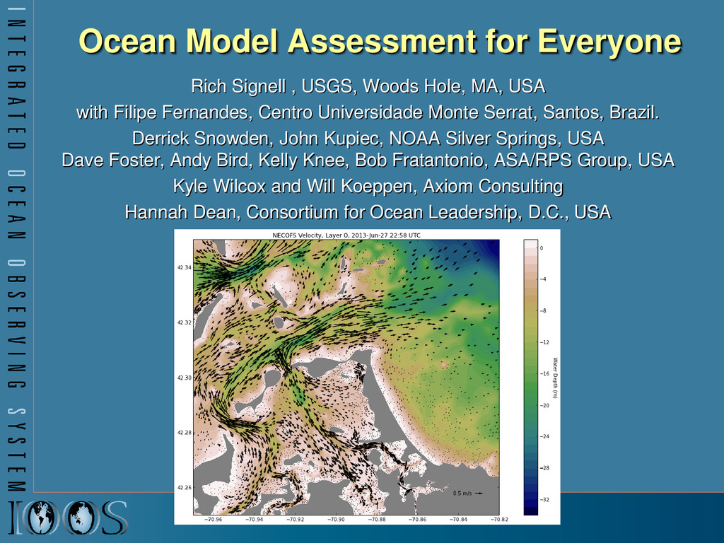
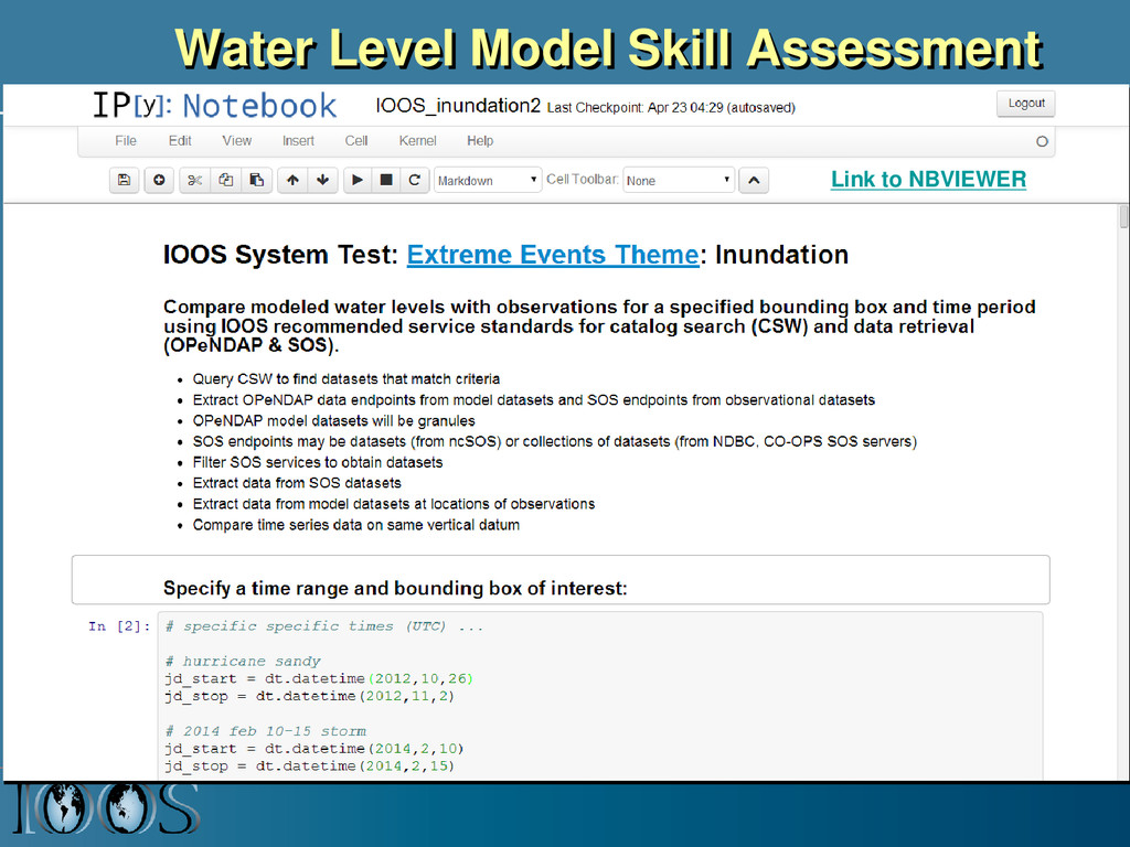
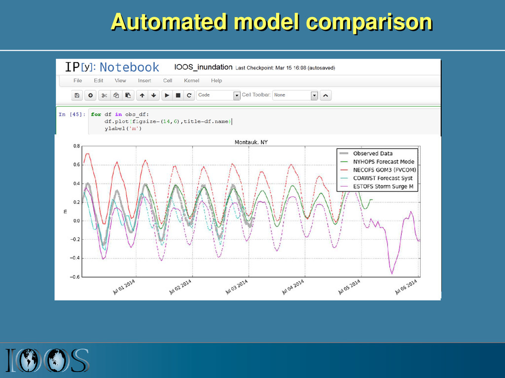
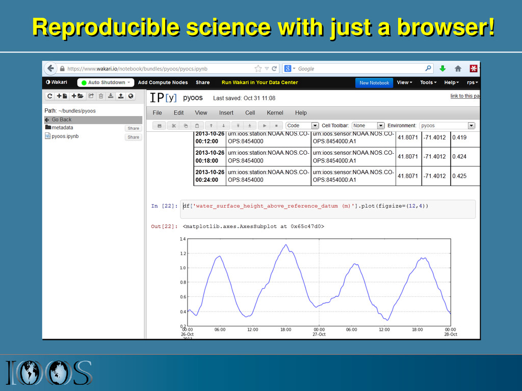
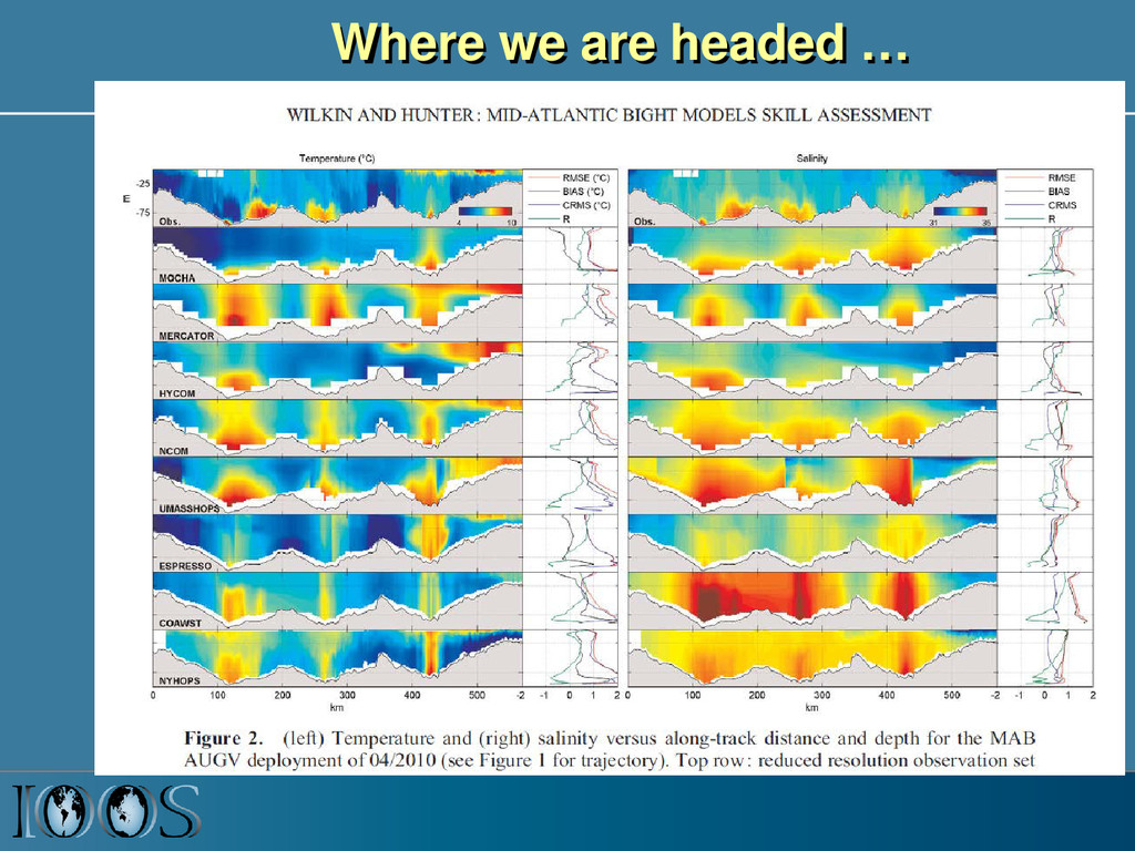
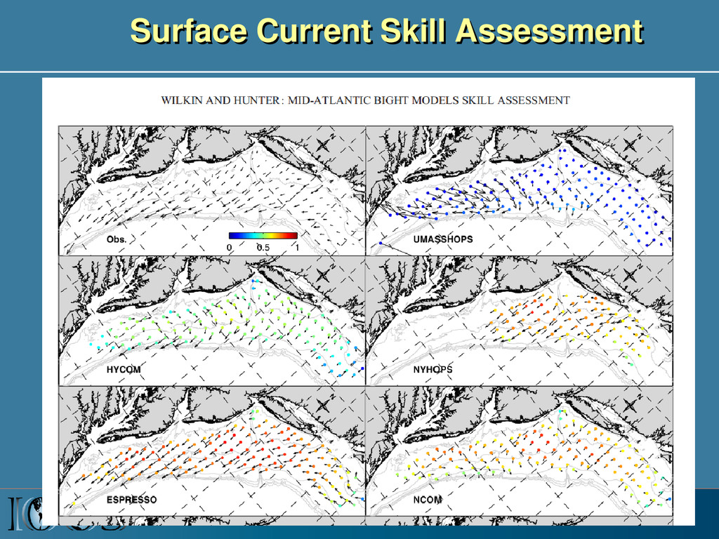
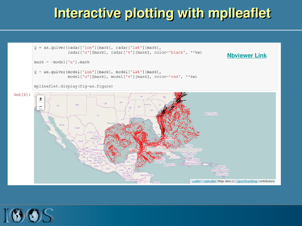
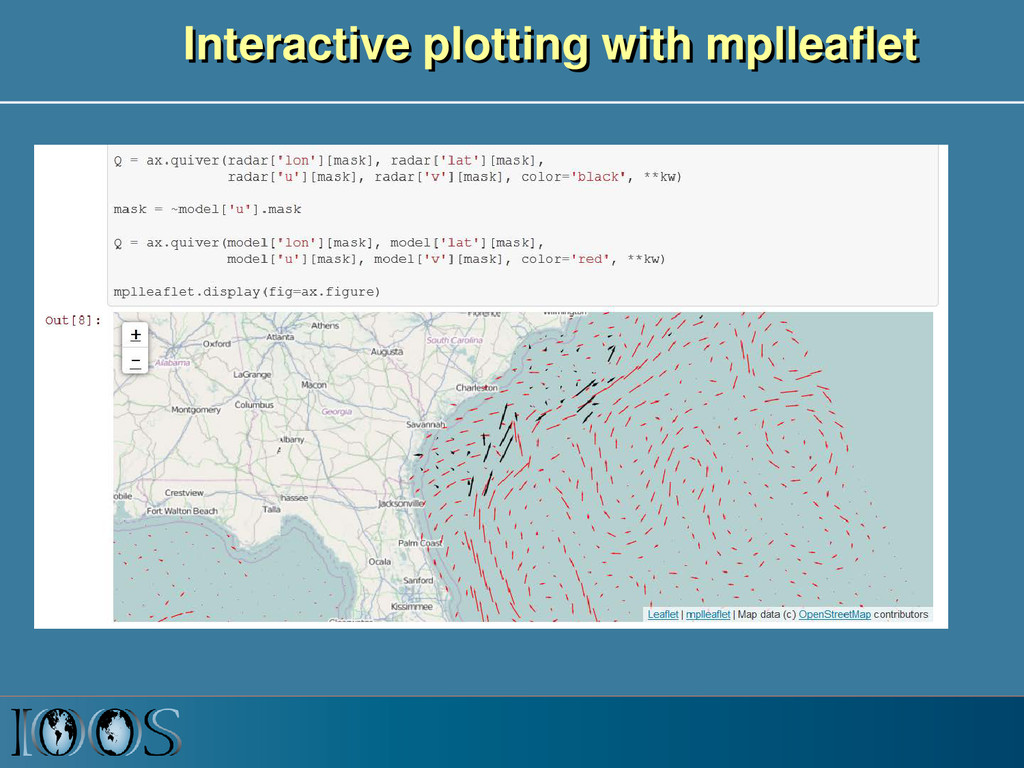
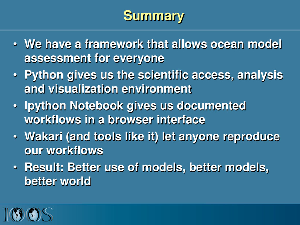
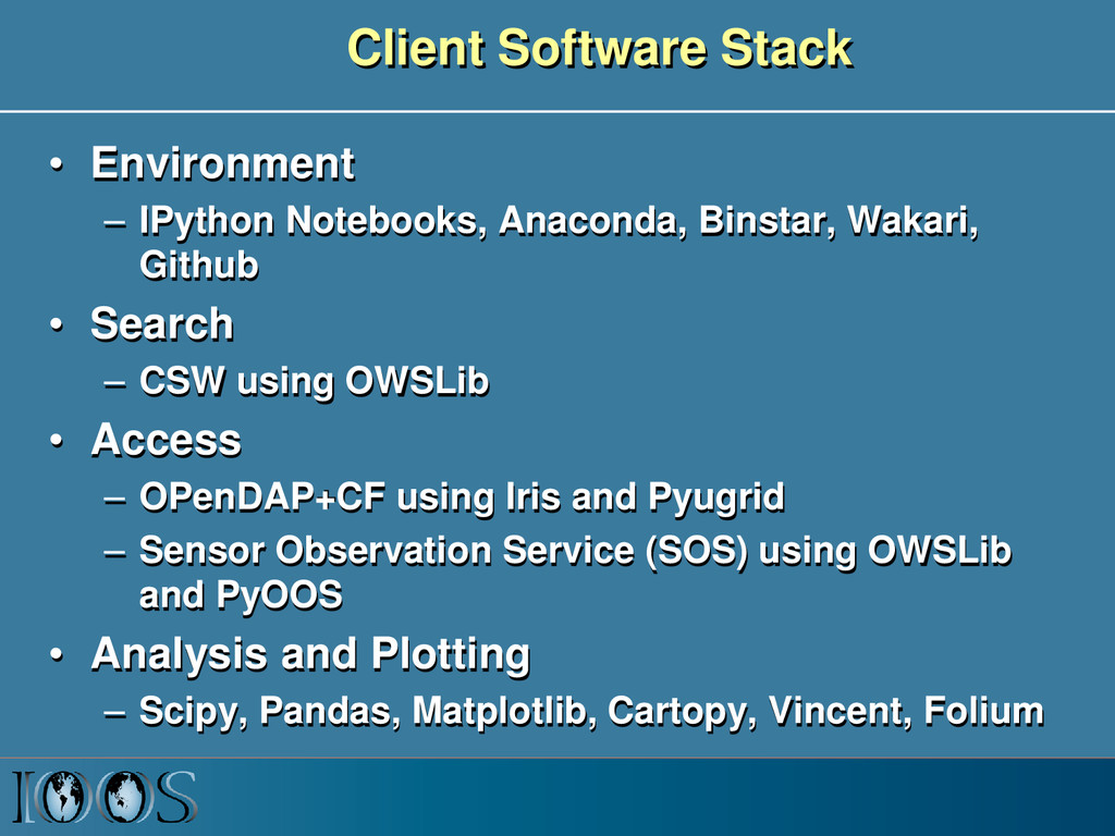
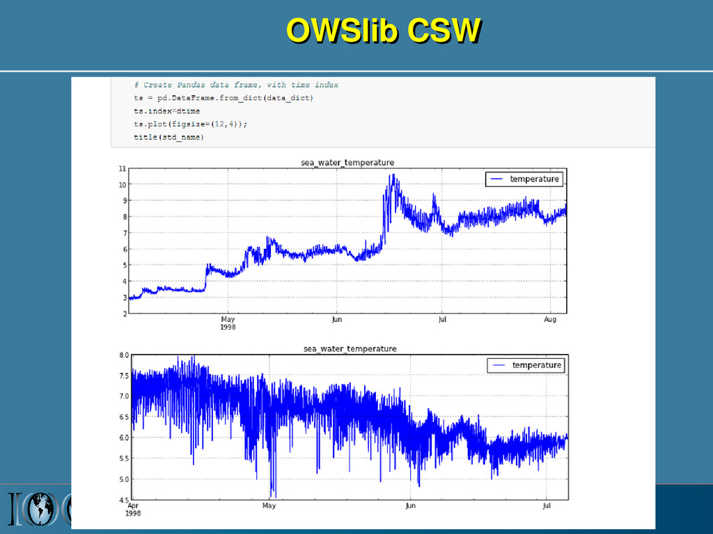
An open source, free infrastructure is being developed by the US Integrated Ocean Observing System (IOOS) that allows anyone with a web browser to assess how well ocean models are performing by comparing with sensor data. Distributed datasets from multiple agencies and organizations are discovered via a catalog search, then data extracted via standard web services, and analyzed and visualized using IPython Notebooks.
Video: http://pyvideo.org/video/2795/ocean-model-assessment-for-everyone

Rich Signell

July 08, 2014
Tweet

More Decks by Rich Signell

Other Decks in Science

Transcript

  1. Ocean Model Assessment for Everyone Rich Signell , USGS, Woods

    Hole, MA, USA with Filipe Fernandes, Centro Universidade Monte Serrat, Santos, Brazil. Derrick Snowden, John Kupiec, NOAA Silver Springs, USA Dave Foster, Andy Bird, Kelly Knee, Bob Fratantonio, ASA/RPS Group, USA Kyle Wilcox and Will Koeppen, Axiom Consulting Hannah Dean, Consortium for Ocean Leadership, D.C., USA
  2. How well do models simulate events? 2 Hurricane Sandy, Ocean

    Grove Pier - New Jersey, October 29, 2012 - Photograph by Bob Bowné Deepwater Horizon Oil Spill, Northern Gulf of Mexico, May 24, 2010. Image from MODIS on NASA’s Terra Satellite.
  3. US Integrated Ocean Observing System (IOOS® ) IOOS® Plan defines:

    • Global Component • Coastal Component  17 Federal Agencies  11 Regional Associations SECOORA Model Skill- Assessment Project: Deborah Hernandez and Vembu Subramanian
  4. IOOS Core Principles • Adopt open standards & practices •

    Avoid customer-specific stovepipes • Standardized access services implemented at data providers 4 Customer Web access service Data Provider Observations Models
  5. Ocean grids are often not regularly spaced! Stretched surface and

    terrain following vertical coordinates Curvilinear orthogonal horizontal coordinates
  6. Time Series, Trajectories Meteorology and Wave Buoy in the Gulf

    of Maine. Image courtesy of NOAA. Ocean Glider. Photo by Dave Fratantoni, Woods Hole Oceanographic Institution
  7. NetCDF Climate and Forecast (CF) Conventions provide a solution Groups

    using CF: GO-ESSP: Global Organization for Earth System Science Portal IOOS: Integrated Ocean Observing System ESMF: Earth System Modeling Framework OGC: Open Geospatial Consortium (GALEON: WCS profile) CF Convention Draft Spec for Unstructured Grid: http://bit.ly/ugrid_cf
  8. IOOS Recommended Web Services and Data Encodings In-situ data (buoys,

    piers, towed sensors) Gridded data (model outputs, satellite) OGC Sensor Observation Service (SOS) OPeNDAP with Climate and Forecast Conventions XML or CSV Binary DAP using Climate and Forecast (CF) conventions Images of data OGC Web Map Service (WMS) GeoTIFF, PNG etc. -possibly with standardized styles Data Type Web Service Encoding
  9. OGC Sensor Observation Service (SOS) • Provides standard access to

    sensor data – GetCapabilities: provides the means to access SOS service metadata – DescribeSensor - retrieves detailed information about the sensors and processes generating those measurements. – GetObservation - provides access to sensor observations and measurement data via a spatio- temporal query that can be filtered by phenomena
  10. IOOS Data Infrastructure Diagram ROMS ADCIRC HYCOM SELFE NCOM NcML

    NcML NcML NcML NcML Common Data Model OPeNDAP+CF WCS NetCDF Subset THREDDS Data Server Standardized (CF-1.6, UGRID-0.9) Virtual Datasets Nonstandard Model Output Data Files Web Services Matlab Panoply IDV Clients NetCDF -Java Library or Broker WMS ncISO ArcGIS NetCDF4 -Python FVCOM Python ERDDAP NetCDF-Java SOS Geoportal Server GeoNetwork GI-CAT Observed data (buoy, gauge, ADCP, glider) Godiva2 CKAN-pyCSW NcML Grid Ugrid TimeSeries Profile Trajectory TimeSeriesProfile Nonstandard Data Files Catalog Services
  11. Summary • We have a framework that allows ocean model

    assessment for everyone • Python gives us the scientific access, analysis and visualization environment • Ipython Notebook gives us documented workflows in a browser interface • Wakari (and tools like it) let anyone reproduce our workflows • Result: Better use of models, better models, better world
  12. Client Software Stack • Environment – IPython Notebooks, Anaconda, Binstar,

    Wakari, Github • Search – CSW using OWSLib • Access – OPenDAP+CF using Iris and Pyugrid – Sensor Observation Service (SOS) using OWSLib and PyOOS • Analysis and Plotting – Scipy, Pandas, Matplotlib, Cartopy, Vincent, Folium
  13. OGC Catalog Services for the Web (CSW) • Provides standardized

    services for search – GetCapabilities : returns the list of queryables – GetRecords : allows geospatial, temporal, keyword and free text search (and other queryables) • http://ex.com/csw?service=CSW&version=2.0.2 &request=GetRecords&typeName=csw:Record &constraintlanguage=CQLTEXT&constraint="c sw:AnyText Like '%pollution%'"
  14. OGC Web Map Service • http://wms_endpoint? REQUEST=GetCapabilities • http://wms_endpoint? REQUEST=GetMap&LAYERS=wave_height&

    BBOX=-72.3,40.3,67.1,44.7& ELEVATION=0&TIME=2014-07- 07T06:00:00.000Z& CRS=EPSG:4326&FORMAT=image/png& WIDTH=256&HEIGHT=256
  15. SECOORA Model Skill Assessment Project Funding from IOOS SECOORA Director:

    Deborah Hernandez Project Lead: Vembu Subramanian
  16. IOOS System Test Project • Test the IOOS data instrastructure

    to solve actual physical and biological scenarios: eat our own dog food • Demonstrates successes as well as issues with standards, metadata, services, tools and data providers • Using Ipython Notebooks as documentation, end-to-end examples and products • Shared Notebooks lead to more efficient, effective and widespread use of model and insitu data System Test Funding from US IOOS Program Office Director: Zdenka Willis Project Lead: Derrick Snowden