Upgrade to Pro — share decks privately, control downloads, hide ads and more …

Day1-1410-A navigable OSM map of Canada? Sooner than you think!

sotm2017
September 01, 2017

Day1-1410-A navigable OSM map of Canada? Sooner than you think!

Friday 2:10pm, Main hall
Frederic Julien, Brian Lau, Martijn van Exel

http://2017.stateofthemap.org/2017/navigable-osm-map-of-canada-sooner-than-you-think/

sotm2017

September 01, 2017
Tweet

More Decks by sotm2017

Other Decks in Research

Transcript

  1. 1 Telenav, Inc. All Rights Reserved © 2017 A navigable

    OSM map of Canada? Sooner than you think! Frederic Julien, Brian Lau and Martijn Van Exel
  2. 2 Telenav, Inc. All Rights Reserved © 2017 AT&T Navigator

    Scout GPS Maps & Navigation WHO IS TELENAV?
  3. 4 Telenav, Inc. All Rights Reserved © 2017 TN MAPPING

    PLATFORM END TO END WORKFLOW OSM Community ACTIVE COMMUNITY MAPPING VEHICLE & PHONE SENSOR DATA QA Partners TOOLS & EDITS TO VALIDATE MAP UPDATES
  4. 5 Telenav, Inc. All Rights Reserved © 2017 Data collection

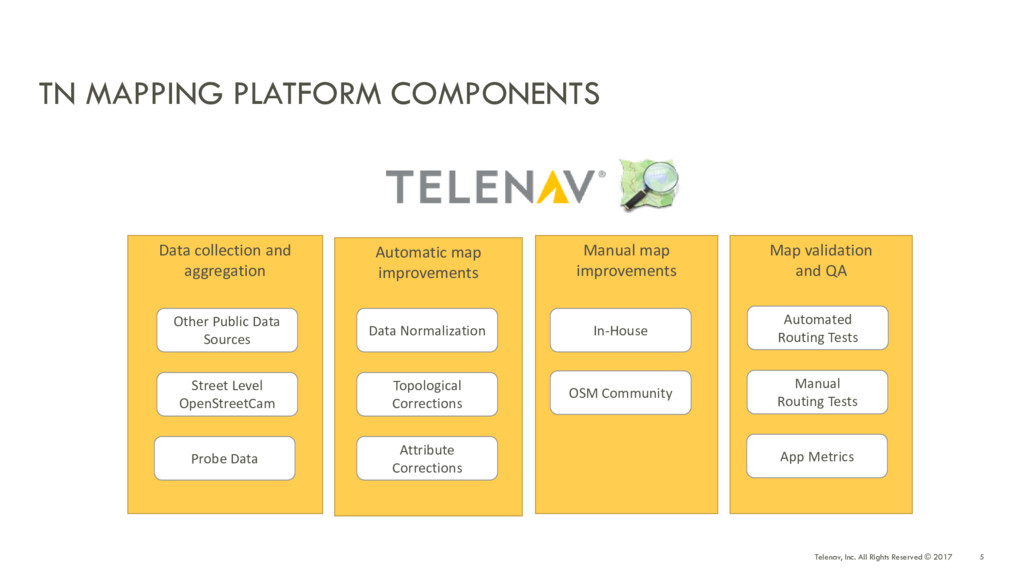
    and aggregation Automatic map improvements Manual map improvements Map validation and QA Data Normalization Topological Corrections Attribute Corrections In-House OSM Community Automated Routing Tests Manual Routing Tests App Metrics Other Public Data Sources Street Level OpenStreetCam Probe Data TN MAPPING PLATFORM COMPONENTS
  5. 6 Telenav, Inc. All Rights Reserved © 2017 Data Source

    Data Type Sensors • GPS probe data • Gyro • Accelerometer • Compass heading • Barometric pressure Camera • Geo-referenced images Map Content • Road geometry • Direction of travel • Turn restrictions • Lane info • Road curvature • Road slope/height • Free flow speed • Lane markings • Street name • Construction zones • Speed limits • Exit sign info • Stop signs • Traffic lights DATA, DATA, DATA…
  6. 7 Telenav, Inc. All Rights Reserved © 2017 AUTOMATED MAP

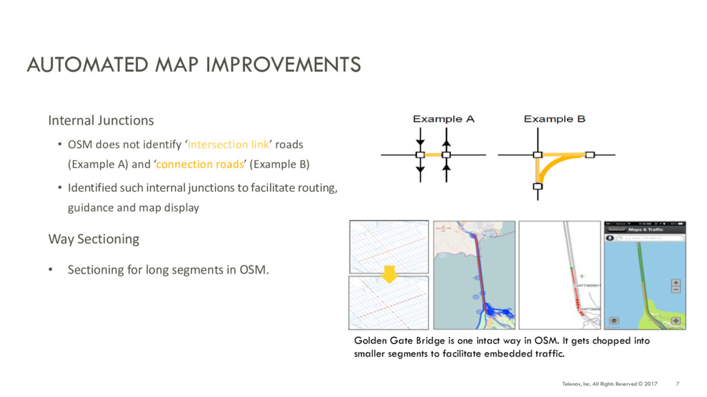
    IMPROVEMENTS Internal Junctions • OSM does not identify ‘intersection link’ roads (Example A) and ‘connection roads’ (Example B) • Identified such internal junctions to facilitate routing, guidance and map display Way Sectioning • Sectioning for long segments in OSM. Golden Gate Bridge is one intact way in OSM. It gets chopped into smaller segments to facilitate embedded traffic.
  7. 8 Telenav, Inc. All Rights Reserved © 2017 SIGNPOST INFORMATION

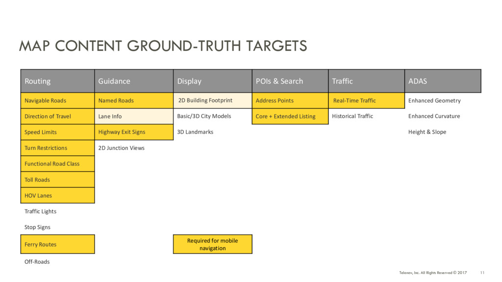
    (MANUAL EDIT) • Critical for guidance • Requires official data (sparse) or Street Level Imagery • Data model proposed by Telenav gained wide acceptance in N-America
  8. 9 Telenav, Inc. All Rights Reserved © 2017 TOOLS FOR

    THE COMMUNITY OpenStreetCam Application ImproveOSM Maproulette Gamified map correction Correction of one-ways and missing roads Street-level image capture and editing tools
  9. 11 Telenav, Inc. All Rights Reserved © 2017 MAP CONTENT

    GROUND-TRUTH TARGETS Routing Guidance Display POIs & Search Traffic ADAS Navigable Roads Named Roads 2D Building Footprint Address Points Real-Time Traffic Enhanced Geometry Direction of Travel Lane Info Basic/3D City Models Core + Extended Listing Historical Traffic Enhanced Curvature Speed Limits Highway Exit Signs 3D Landmarks Height & Slope Turn Restrictions 2D Junction Views Functional Road Class Toll Roads HOV Lanes Traffic Lights Stop Signs Ferry Routes Required for mobile navigation Off-Roads
  10. 12 Telenav, Inc. All Rights Reserved © 2017 CANADA MAP

    CONTENT WEEKLY METRICS 102% 104% 117% 106 % 795000 800000 805000 810000 815000 820000 825000 830000 835000 840000 845000 Road Geometry (miles) Target Actuals Cumulative Target 445000 450000 455000 460000 465000 470000 475000 480000 485000 Road Names (miles) Target Actuals Cumulative Target 0 10000 20000 30000 40000 50000 60000 Turn Restriction (count) Target Actuals Cumulative Target 28000 29000 30000 31000 32000 33000 34000 35000 36000 37000 One Way (miles) Target Actuals Cumulative Target
  11. 13 Telenav, Inc. All Rights Reserved © 2017 TELENAV MAP

    EDITS IN CANADA 2016-17 • Road geometry (miles): edited 52,056 miles (17.70% of all OSM edits for road geometry) • Road name (miles): edited 41,182 miles (21.29%) • Oneway (miles): edited 18,025 miles (48.36%) • Signposts: edited 1,946 signpost (21.60%) • Turn restrictions: edited 49,358 turn restrictions (93.61%)
  12. 15 Telenav, Inc. All Rights Reserved © 2017 STREET VIEW

    IMAGERY (DATA COLLECTION) Kilometers Images Global 1.6M 58M (66K Tracks) US 149K (9%) 7.3M (12%) Canada 141K (8.8%) 8.8M (15%)
  13. 17 Telenav, Inc. All Rights Reserved © 2017 WHAT WE

    COULD HAVE DONE BETTER? • Telling people what we were planning in advance • Allow plenty of time for discussion • More research into local mapping practices + asking more questions • Be unafraid to step back / stop in place and rethink what we’re doing • Less focus on quantity over quality • Community training
  14. 20 Telenav, Inc. All Rights Reserved © 2017 + +

    We did this together – first for US, then Canada – where will we take OSM next?