Upgrade to Pro — share decks privately, control downloads, hide ads and more …

Harrison County- Abandoned Mine Project Texas Railroad Commission

Harrison County- Abandoned Mine Project Texas Railroad Commission

Sanborn

More Decks by Texas Natural Resources Information System

Other Decks in Technology

Transcript

  1. Harrison County- Abandoned Mine Project Texas Railroad Commission January 10th,

    2017 Bridget MarcoDe & Hugh Bender ©2017, The Sanborn Map Company, Inc.
  2. 2 Decision Support Visualization Systems Software Applications Value Added Services

    (Base Map Analysis) Data and Map Production Past performance and primary capabiliAes •  Decision Support Systems –  Southern Wildfire Risk Assessment –  Forestry and Ecosystem Management –  Emergency Response •  VisualizaJon Systems –  2D –  3D •  SoKware ApplicaJons –  GIS SoNware Development (Enterprise/ Desktop/Web) –  Portals and DistribuAon Tools •  Value-Added Services –  Land use and land cover analyses –  Change detecAon –  Other imagery analysis services •  Mapping & Remote-Sensed Services –  LiDAR, Digital Orthoimagery, Photogrammetric, Topographical Maps
  3. 2/3/17 3 •  Ground Survey since 1866 •  Aerial Survey

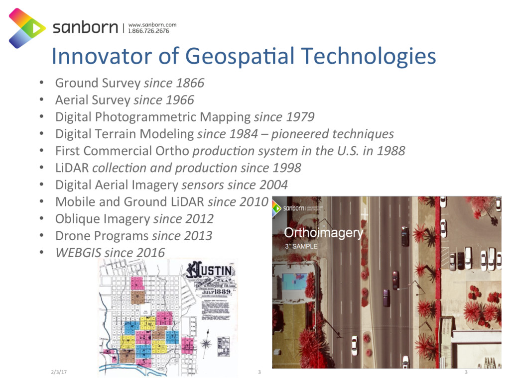
    since 1966 •  Digital Photogrammetric Mapping since 1979 •  Digital Terrain Modeling since 1984 – pioneered techniques •  First Commercial Ortho produc6on system in the U.S. in 1988 •  LiDAR collec6on and produc6on since 1998 •  Digital Aerial Imagery sensors since 2004 •  Mobile and Ground LiDAR since 2010 •  Oblique Imagery since 2012 •  Drone Programs since 2013 •  WEBGIS since 2016 Innovator of GeospaAal Technologies 3
  4. Imagery Experience 1989; developed proprietary soKware for developing digital orthoimagery

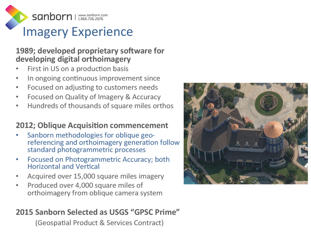
    •  First in US on a producAon basis •  In ongoing conAnuous improvement since •  Focused on adjusAng to customers needs •  Focused on Quality of Imagery & Accuracy •  Hundreds of thousands of square miles orthos 2012; Oblique AcquisiJon commencement •  Sanborn methodologies for oblique geo- referencing and orthoimagery generaAon follow standard photogrammetric processes •  Focused on Photogrammetric Accuracy; both Horizontal and VerAcal •  Acquired over 15,000 square miles imagery •  Produced over 4,000 square miles of orthoimagery from oblique camera system 2015 Sanborn Selected as USGS “GPSC Prime” (GeospaAal Product & Services Contract)
  5. Texas Programs of Relevance •  CAPCOG: 1995 through 2011 • 

    NCTCOG – HGAC – Lubbock - IBWC •  TNRIS/FEMA 2006 Coastal Lidar •  2015-2016 TX Orthos & Obliques •  2015 Houston Impervious Cover •  HPID’s & StratMap Vendor 2/3/17 ©2013, The Sanborn Map Company, Inc. 6
  6. Aerial Data AcquisiAon •  8 Fixed-wing aircraNs: –  2 Twin-engine

    Turbine (Aero- Commander) –  2 Twin-engine piston Navajos –  3 Single-engine piston (Cesnas) –  1 Leptron Avenger B (UAS) •  15 Digital Aerial Cameras/Sensor: –  3 Vexcel Ultracam Eagles, –  2 Vexcel Ultracam D –  5 MIDAS Oblique –  1 Visual Intelligence N-Oblique System –  2 Leica ALS-70HP Airborne Lidar –  2 Leica RCD30 Aerial Camera Systems (Add on to Leica ALS70 Lidar unit) 2 Ground Based Lidar units –  1 MLS - Mobile –  1 Terrestrial Scan - Land
  7. Harrison Mines Program •  Sanborn collected lidar and imagery over

    an abandoned mine site located in Harrison County, Texas. The data will be used by the Texas Abandoned Mine Land Program, a division of Railroad Commission of Texas, for reclamaAon design, calculaAon of earthwork volumes associated with abandoned open pit surface mines, and vegetaAon biomass calculaAon. Orthoimagery will be used to complement point density for enhanced 3-D visualizaAon techniques. Sanborn will present on the collecAon process and the usability of high-density point lidar. •  Area: 1,874 acres/5.36 sq. miles •  The Original Plan •  Plan B •  Usability of high-density point lidar? 2/3/17 ©2013, The Sanborn Map Company, Inc. 12
  8. Original Plan UAV flights with: •  YELLOWSCANTM LiDAR •  Lidar:

    48 flight lines, 14 days to acquire •  Imagery: Sony 7 m-2 Camera -Ortho: 52 flight lines, 7 days to acquire 2/3/17 ©2013, The Sanborn Map Company, Inc. 13
  9. Pro’s to UAS system •  Great tool for open /

    clear areas. –  Other successful project with UAS/UAV include •  Golf courses •  Open Mines •  Farming/Ranching •  Disaster Response (local) •  Reservoirs Analysis •  Dangerous or difficult to fly spaces •  Dam Faces – Power Lines •  Ideal for small projects (1-2 sites) –  This will change over Ame making larger sites more cost effecAve. •  GOOD NEWS: Sensors very affordable so far. 2/3/17 ©2013, The Sanborn Map Company, Inc. 14 3-5cm verAcal accuracy
  10. Cons of UAS Approach •  Sensors sJll in infancy or

    “bleeding edge” –  Yellow Scan Lidar Sensor did not perform as stated •  Too weak a signal – not enough penetraAon •  Requirement of 2 person teams, including a pilot, is not cost effecJve. •  Struggle with Heavily Vegetated Areas –  Height of Trees and density proved to be more problemaAc than anAcipated. Required UAS to fly higher than 400 N. –  Varied terrain on this site complicated things further –  UAS at High resoluAon = low alAtude, = X Ames the normal number of flight lines. 2/3/17 ©2013, The Sanborn Map Company, Inc. 17
  11. The Future of UAV’s •  The future of UAS/UAV is

    bright! •  However it is also limited! •  Current constraints slow the use and development of UAS / UAV. –  Height limitaAon of site. –  Pilot requirement limits cost effecAveness (2 person job) –  Sensors limited power won’t penetrate dense vegetaAon –  High resoluAon means LOTS of flight lines. –  UAS would have taken •  2 weeks for lidar •  1 weeks for imagery 2/3/17 ©2013, The Sanborn Map Company, Inc. 18
  12. The Con’s Won ! The Sanborn Advantage •  Had to

    make a quick decision. •  Sanborn’s resources and experience allowed us to modify and change the project, in a day, keeping to the specs and actually speeding up the program. •  Prior Experience for several projects such as in Edmond, OK and DC OCTO Project: •  Dual lidar/camera sensor system (ALS70/RCD30) •  ExcepJonal coordinaJon between RRC, QA/QC vendor and TNRIS 2/3/17 ©2013, The Sanborn Map Company, Inc. 20
  13. Harrison Mines Plan B Leica ALS-70 LiDAR system & 80

    MP RCD30 system •  Sanborn has been uAlizing this medium-format sensor which provides the unique capability to be mounted with Sanborn’s Leica ALS-70HP LIDAR system in a single sensor port, allowing mobilizaJon of both systems in a single camera aircraK. •  Will generate LiDAR and ortho products which meets or exceeds the RFP specificaAons. –  The 4-band imagery will be collected at 5.6 cm GSD (project requirement 7.5 cm) and aggregate density of the LiDAR dataset will be close to 80 ppm (project requirement 30 ppm). The RCD camera, with a 4th band and calibrated lens, will exceed the contract requirements and has a proven track-record in meeAng mapping grade accuracies. 2/3/17 ©2013, The Sanborn Map Company, Inc. 21 Leica RCD30 SpecificaJons CCD sensor size: 10320 x 7752 pixels Lens system and aperture: f = 80mm 1/2.8, 1/4, 1/5.6, and 1/8 Physical pixel size: 5.2 μm Maximum frame rate: <1.25 seconds per frame CCD signal to noise raJo: 73 dB CCD image dynamic range: 14 bit; workflow dynamic: 16 bit In-flight data storage system: Solid state mass memory, capacity of up to 1600GB (33,600 RGBN images)
  14. Dual System Advantages •  In order to maximize penetraAon foliage,

    our new project plans indicates the data will achieve a density of approximately 40 ppm per swath, since we are collected at 55% side-lap. The resulAng aggregate density of the LiDAR dataset will be close to 80 ppm. This provided a dataset that exceeds the requirements. –  Dual Collect = 45 minutes vs 3 weeks for UAS. –  LiDAR and Imagery collected on October 21, 2016 2/3/17 ©2013, The Sanborn Map Company, Inc. 23
  15. Usability of high-density point lidar. •  The Jury is out

    on this topic. More quesJons than answers! Need more end user feedback. •  Lidar: Higher PPM –  There is an upper PPM limit to the funcAonal uses of such high density imagery. –  Bare earth is sAll the most widely used applicaAon. •  Bio-Mass CalculaJons –  Good for tree volumes –  Is it really accurate for mid-range vegetaAon? Yes/But! •  (Plants die off and regrow based on climate issues (H2O, Fire, Draught & Temperature) •  IT IS THE JOB OF GIS PROFESSIONALS To: –  Have an idea of the “paint brush” – determine the PPM. 2/3/17 ©2013, The Sanborn Map Company, Inc. 26
  16. In a Nutshell •  Harrison Mines Project Lessons – VegetaAon planning

    & terrain = criAcal – Chose the right sensor – RegulaAons will evolve & make UAS beter – SIZE MATTERS! UAS will not replace tradiAonal aerial systems. They will complement them. – Need More Feedback from End Users. •  InteresAng to see how the RRC uAlizes the data. Will the PPM density be valuable or would much less accomplish the same things 2/3/17 ©2013, The Sanborn Map Company, Inc. 27
  17. Thanks Bridget Marco-e Hugh Bender Program Manager Director of Strategic

    Accounts [email protected] [email protected] (719) 244-2311 c (512) 983-7596 c 512.983.7596 ©2015, The Sanborn Map Company, Inc.