Upgrade to Pro — share decks privately, control downloads, hide ads and more …

Land Cover Change for the Houston Region and the Galveston Bay

Land Cover Change for the Houston Region and the Galveston Bay

Bill Bass, HARC

More Decks by Texas Natural Resources Information System

Other Decks in Technology

Transcript

  1. Land Cover Change for the
    Houston Region and Galveston Bay
    Bill Bass, GISP

    View Slide

  2. Galveston Bay Watershed
    • The Galveston Bay watershed is
    approximately 24,000 square
    miles.
    • Approximately half the
    population of Texas (27.5 million)1
    live in the Galveston Bay
    watershed.
    1U.S. Census, July 2015

    View Slide

  3. Changing Landscapes
    Source: Houston-Galveston Area Council, Circa 2000

    View Slide

  4. Changing Landscapes
    Source: Google, Circa 2015

    View Slide

  5. Changing Landscapes
    Source: Houston-Galveston Area Council, Circa 2000

    View Slide

  6. Changing Landscapes
    Source: Houston-Galveston Area Council, Circa 2014

    View Slide

  7. Changing Landscapes
    Source: Houston-Galveston Area Council, Circa 2000

    View Slide

  8. Changing Landscapes
    Source: Grand Central Park

    View Slide

  9. Land Cover Change
    • Impervious & developed areas growth
    • Wetland areas decreased by 54,000 acres

    View Slide

  10. Developed Areas 1996
    Animation

    View Slide

  11. Developed Areas 2010
    Animation

    View Slide

  12. Wetland Areas 1996
    Animation

    View Slide

  13. Wetland Areas 2010
    Animation

    View Slide

  14. Land Cover Change Animations
    1996 - 2010
    • Harris & 
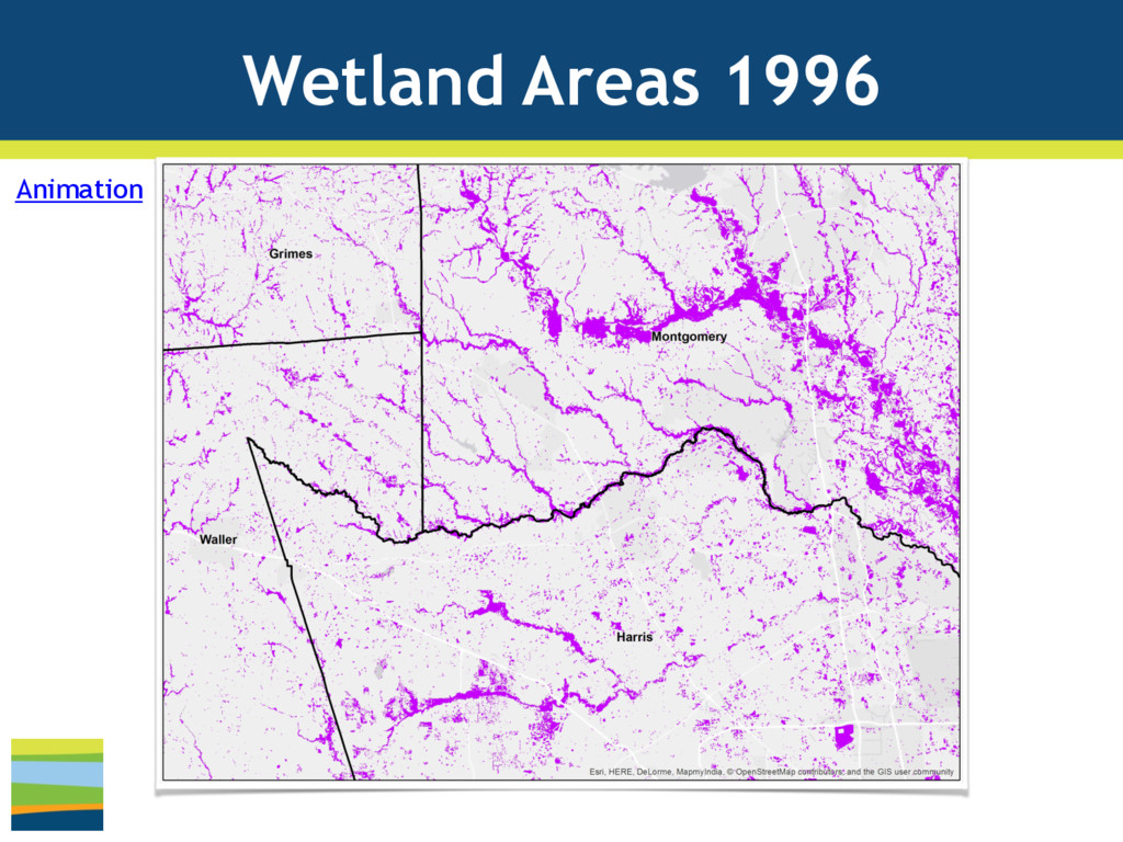
Montgomery Counties

    Developed Areas https://vimeo.com/176231053

    Wetland Areas https://vimeo.com/176497180
    • Houston-Galveston Region

    Developed Areas https://vimeo.com/176218783 

    Wetland Areas https://vimeo.com/176220936

    View Slide

  15. Galveston Bay Report Card
    • Annual citizen driven
    scientific analysis of
    Galveston Bay
    • Engage community
    about health of
    Galveston Bay
    • Supported by a grant
    from the Houston
    Endowment
    • Implemented by
    Galveston Bay
    Foundation & HARC
    Inspire people to take actions that protect
    and preserve Galveston Bay.

    View Slide

  16. Inputs and Grading
    TPWD Coastal
    Fisheries
    TCEQ
    SWQM
    NOAA C-CAP
    Land Cover
    NOAA Sea Level
    Rise Data
    Texas Colonial
    Waterbirds Data

    View Slide

  17. GalvBayGrade.org
    • Overview
    • Find Your
    Watershed Tool
    • See the Grades
    • What You Can Do
    • Cover Stories
    http://GalvBayGrade.org
    New for
    2016

    View Slide

  18. Overview
    • About the Bay
    • Bay facts
    • Map of watershed
    • About this Project
    • 6 Topic Areas
    • 19 Indicators
    • How We Grade
    • Letter Grading
    System
    • Descriptors from
    ‘Excellent’ to
    ‘Critical’
    • Public Audience
    http://GalvBayGrade.org

    View Slide

  19. Find Your Watershed
    • Find results by
    watershed
    • Enter an address

    or explore the map by
    clicking on a watershed.
    http://GalvBayGrade.org

    View Slide

  20. See The Grades
    • Shown by
    • Topics Areas
    • Indicators
    • Prior year change
    • ‘What We Can Do’
    tips for each
    indicator
    http://GalvBayGrade.org

    View Slide

  21. What You Can Do
    • Filter by Topic Area
    • Search by Keyword
    • Suggestions linked
    to resources.
    http://GalvBayGrade.org

    View Slide

  22. Cover Stories
    • Blog articles and in-
    depth stories on
    current events.
    • Links to current
    and past full
    reports.
    • Report updated
    annually.
    http://GalvBayGrade.org

    View Slide

  23. GalvBayGrade.org
    Research Contacts
    • Lisa Gonzalez

    HARC President 

    [email protected]
    • Erin Kinney, PhD

    HARC Research Scientist
    Coastal Ecology

    [email protected]
    • Heather Schiappa

    Galveston Bay
    Foundation 

    Report Card Coordinator

    [email protected]

    View Slide

  24. HARCresearch.org
    HARC (härk), n.
    an independent research
    hub helping people thrive
    and nature flourish.
    @bass_wm
    www.linkedin.com/in/wmbass
    Bill Bass, GISP
    GIS & IT Manager
    (281) 364-6087
    [email protected]

    View Slide