Upgrade to Pro — share decks privately, control downloads, hide ads and more …

iShake Paper

jackdreilly
December 21, 2011

iShake Paper

jackdreilly

December 21, 2011
Tweet

Other Decks in Education

Transcript

  1. iShake: Using Mobile Phones as Seismologic Sensors Jack Reilly UC

    Berkeley Shideh Dashti University of Colorada Boulder Mari Ervasti VTT Technical Research Centre, Finland Jonathan Bray UC Berkeley Steven Glaser UC Berkeley Alexandre Bayen UC Berkeley ABSTRACT There are a variety of approaches to seismic sensing, which range from collecting sparse measurements with high-fidelity seismic stations to non-quantitative, post-earthquake surveys. The sparse nature of the high-fidelity stations and the inaccu- racy of the surveys create the need for a high-density, semi- quantitative approach to seismic sensing. To fill this void, the UC Berkeley iShake project designed a mobile client- backend server architecture that uses sensor-equipped mo- bile devices to measure earthquake ground shaking. The de- vices act as distributed sensors that enable measurements to be taken and transmitted with a network connection. Shak- ing table testing was used to assess the quality of the mea- surements obtained from the iPhones and iPods on a bench- mark of 150 ground motions. Once triggered by a shaking event, the devices transmit sensor data to a backend server for further processing. After a seismic event is verified by high-fidelity stations, filtering algorithms are used to detect falling phones, as well as device-specific responses to the event. A method was developed to determine the absolute orientation of a device to estimate the direction of first mo- tion of a seismic event. A “virtual earthquake” pilot test was conducted on the UC Berkeley campus to verify the oper- ation of the iShake system. By designing and fully imple- menting a system architecture, developing signal processing techniques unique to mobile sensing, and conducting shak- ing table tests to confirm the validity of the sensing platform, the iShake project serves as foundational work for further studies in seismic sensing on mobile devices. General Terms Mobile Phones, Accelerometer, Earthquake, Seismograph, Signal Processing, Crowdsourcing, Participatory Sens- ing 1. INTRODUCTION Emergency responders must assess the effects of an earthquake exhaustively and rapidly so that they can re- spond effectively to the damage it has produced. While the U.S. Geological Survey (USGS) has made signif- icant strides in developing methodologies that deliver rapid and accurate post-earthquake information, short- comings exist due to the limited number of strong mo- tion stations available to construct ShakeMaps [28] or due to the qualitative nature of the observations pas- sively obtained from untrained individuals needed to construct Did You Feel It? (DYFI ) -based maps [4]. The iShake project proposes an innovative use of mo- bile devices and information technology to bridge the gap between the high quality, but sparse, ground mo- tion data that is used to help develop ShakeMaps [28], and the low quality, but large quantity, observational data collected through DYFI. Rather than using people as measurement devices, this project uses their mobile device to measure ground motion intensity parameters and process the data on a central server. This research involves the use of the iPhone as a new ad- hoc sensor array based on par- ticipatory sensing, with mobile phones as the nodes. The growing number of sensors in today’s smartphones (including accelerometers, magnetometers, and gyro- scopes) and the extensible mobile OS’s have enabled scientific sensing applications to be crowdsourced to an ever-growing population of smartphone users. In particular, the iShake system was created to take advantage of the new source of seismic sensing capabil- ities offered by the accelerometer and magnetometer on the smartphones. A client application for the iPhone and iPod products was developed as the means of sens- ing ground motion activity. After a potential earth- quake event is sensed, the data measured by the client application are streamed rapidly to the backend servers, where the raw data can be properly processed and ag- gregated with other client data. Then, summary data from the event, in the form of intensity maps[28], can be immediately provided to emergency workers (as well to the general public) to aid in rescue missions. In order to test the method in an earthquake set- ting, a series of shaking table tests based on 150 his- torical earthquake records were performed as a part of this study. The 1-D shaking table testing (where n-D describes n degrees of freedom of movement used for shaking) was conducted at UC San Diego (ST-1) in the South Powell Lab, while the 3-D shaking table test- 1
  2. ing was conducted at the Richmond Field Station of UC

    Berkeley (ST-2). Testing shows that ground mo- tion parameters such as peak ground acceleration, peak ground velocity, spectral acceleration, and Arias Inten- sity are captured accurately by iPhones which demon- strates that iPhones (and soon other cellular phones) can measure reliably the shaking produced by an earth- quake. A field test was conducted to test the iShake sys- tem in which users on the UC Berkeley campus simul- taneously used the iShake application and shook their phones to simulate an earthquake (hence the term “vir- tual earthquake”). The envisioned use case for the iShake system is as follows. Most smartphone users have been accustomed to charging their phone nightly or while at their desk during a workday. During such times of inactivity, the mobile device will be leveraged as a sensing and data- transmission unit. The onboard array of sensors (ac- celerometer, GPS, magnetometer) will then be enabled to capture ground-motion events and properly deter- mine its orientation from any potential position, be it lying face down on a desk, or upright in a charger. While an unoptimized implementation of the software may pose a problem to battery life, the ability of mod- ern mobile operating systems to detect when a device is charging (such as Apple iOS and Android) circum- vents such issues. Additionally, the stationary nature of charging phones also helps to target the ideal use case of sensing while the user is disengaged from the device. The aforementioned use case motivates the design de- cisions taken while developing the system architecture for iShake. Contributions of this article are enumerated as fol- lows. The iShake system is the first known description of a software and hardware system for the application of mobile phones for seismic sensing. This is also the first known participatory sensing system to report ground motion data within an orientation-aware context, giv- ing both the magnitude and cardinal direction of shak- ing. Given the mobile nature of the computing plat- form, there are many uncertainties introduced into the sensing environment. The iShake project makes contri- butions to the mobile computing field by developing al- gorithms that account for such uncertainties inherent to the field, and implementing techniques that reduce the noise associated with uncertainty. In Section 4, a mobile client application architecture is developed to determine when sensor-data transmission should and should not occur, basing the decision on the mobile device’s cur- rent environment. Further, Section 5 details several sig- nal processing algorithms that filter out environment- specific noise, which is variable from device-to-device (such as smartphones falling off a table while sensing for ground motion, or device-related resonance unre- lated to the ground motion) and unavoidable in mobile computing and participatory sensing applications. By implementing a finite-length circular buffer, the client software allows for very low-amplitude seismic waves to be captured and transmitted to the central server, even when the wave’s first-arrival amplitude was not enough to set off the application’s trigger. This work is the first rigorous and quantitative testing of iPhone devices for the purpose of determining the suitability of on-board accelerometers for seismic sensing application. Finally, this article details an actual field test of the iShake sys- tem conducted on the UC Berkeley campus and sur- rounding areas, which demonstrated the feasibility of running this system in real time. The article is organized as follows. First, Section 2 de- tails similar work in the intersection of real-time earth- quake sensing and analysis and participatory sensing efforts in the geological sciences (and broader applica- tions of crowdsourced sensing as well). The necessary functionality of a seismic sensing device is then dis- cussed, as well as the viability of using smartphones as such sensing devices. Then in Section 6, the shake- table testing of the iPhone and iPod Touch devices is discussed, with an assessment of the accuracy of the accelerometers of these devices. The iShake front end and back end systems are described to provide insight into the requirements of such a system. Signal process- ing and cross-correlation techniques are outlined in the proceeding section. Finally, the field test is discussed and a conclusion on the iShake project and system is given. 2. RELATED WORK In the last decade, significant progress was made in rapid, post-earthquake analysis and visual representa- tion of seismic data [28, 11, 4]. The demand for imme- diate analysis of earthquakes comes not only from the scientific community, but also from public and private post-earthquake response groups as well as prepared- ness exercises and disaster planning groups [23, 13]. The USGS offers a service called ShakeMaps [28] that provides shaking intensity and ground motion maps of earthquakes minutes after an earthquake event hap- pens. ShakeMaps leverages a network of regional seis- mic stations to create their ground motion estimates. Due the sparseness of the stations, ShakeMaps must in- terpolate over large areas to stabilize contouring. The interpolated values from these plots have no validation method due to the lack of seismic stations in a given area. Given the growing number of smartphone users, particularly in urban areas, a denser mesh of sensor nodes can be supplied by the iShake system to reduce the interpolation distances involved in creating spatial intensity maps. The DYFI project is another program offered by the USGS, which uses human observations that are volun- 2
  3. tarily submitted through the Internet, hours to days after an

    earthquake, to develop a Community Internet Intensity Map based largely on the Modified Mercalli Intensity (MMI) scale [19]. In addition to untrained hu- mans being only a rough qualitative indicator of earth- quake effects, the response times of such data sources would be expected to increase with the severity of the event. The iShake project aims to create more quan- titative sensing data than the DYFI approach, while automating the response method via a mobile client ap- plication. Reducing response time becomes important as networks are known to experience downtime immedi- ately following natural disasters from network overload and infrastructure damage [26, 20]. The idea for using mobile devices as an earthquake sensing platform was inspired by the rising field of par- ticipatory sensing, introduced by Burke, Estrin, Hansen et al. [10], where the idea of the “shareability” of indi- vidual’s sensor data is introduced. A general model of crowdsourced computation has been proposed in [29]. Participatory sensing has become influential in civil en- gineering by introducing modern sensing techniques to traditional civil engineering practices. In particular, Balakrishnan, Madden et al. have developed a mo- bile sensing platform attached to vehicles that enables monitoring of street surface conditions [14, 18], and new earthquake sensing techniques have emerged[11, 27, 23], which are detailed herein. In a first for mobile participatory sensing in seis- mic applications, Estrin et al. successfully captured an earthquake event in the Los Angeles area using a Nokia N95 mobile phone [16]. The acceleration signal showed a clear capturing of both the s-wave and the harder to detect p-wave of the earthquake event, giving promise to the field of seismic mobile sensing. In another novel approach to seismic data collection, researchers have been using the social micro-blogging site Twitter as a mechanism for early-warning [27, 9]. Results from Sakaki et al. [27] have even demonstrated that 96% of earthquakes in Japan can be detected by mining data from Twitter, and can often be detected quicker than the notifications posted by the Japanese Meteorological Agency. The Quake-Catcher Network (QCN) [11], a research project led by Stanford University and UC Riverside, seeks to utilize laptops and personal computers to record ground-motion data. When internal accelerometers are not available, inexpensive external accelerometers can be used as well. The QCN has had success in detect- ing and analyzing earthquakes with user devices, ev- idenced by accurately calculating the epicenter of an actual earthquake event. Similar work is also being conducted by the Califor- nia Institute of Technology with the Community Seis- mic Network [23]. The project attempts “to produce block-by-block measurements of strong shaking during an earthquake” to aid emergency-relief efforts. The iShake system is able to extend the techniques used by QCN and others by utilizing mobile networks and smartphone capabilities. Location determination of QCN sensors are based on a registered address to a specific IP address or regional estimation of location based on current IP address. The IP address registra- tion method limits the device to a single location of us- age while the latter method can often only give a general region (on the order of the size of city). Smartphones al- most always come equipped with advanced geo-location features, which not only allow for a high degree of ac- curacy for location, but also allow the devices to use the iShake application in any environment with a net- work connection. For example, not only can a mobile device use GPS technology for global positioning of the recorded seismic events, but additional assisted GPS (aGPS) methods are utilized by smartphones to deter- mine approximations of location information in the ab- sence of GPS availability, such as cell-phone triangula- tion and wireless-router location lookup-tables [3]. Due to the lack of orientation-aware sensors (such as a magnetometer) in lap- and desk-top computers, existing seismic participatory sensing systems do not provide any information on the heading (the cardinal direction) of the personal computer. While this allows for computation of estimates for epicenter of earthquake and intensity values, there is no way for the measure- ments to capture direction of first motion or determina- tion of fault-plane [19]. Since most smartphones come equipped with magnetometers (including the iPhone 3GS used in our testing), the iShake system uses these sensors to capture additional seismological information on the recorded shaking events. 3. USING THE IPHONE AS SEISMOGRAPH 3.1 Required Sensing Capabilities For a device to be a suitable seismic sensor, it must contain an accelerometer to measure ground motion, aGPS to determine its location and a magnetometer to determine the heading of the device. The iPhone 3GS satisfies these requirements, and thus was chosen as the mobile device for testing (although, any mobile device with similar sensors would be as suitable). Additionally, the accelerometer must possess a given level of fidelity to capture key seismic properties such as peak ground acceleration (PGA) or spectral response. Since the de- vice can be set in any arbitrary position, the device must also recover its orientation to transform properly the recorded data to be consistent with other devices’ measurements. 3.2 Device Orientation 3
  4. Gravity Earth's Magnetic Field Y-axis Z-axis X-axis Figure 3.1: Using

    the earth’s gravity and mag- netic field as reference vectors and utilizing the Triad algorithm [7], the rotational orientation of the iPhone may be determined from anywhere and any position. Determining orientation aids in the understanding of seismic features such as epicenter location and direction of first move- ment. One of the appeals of using mobile devices as seismic sensors is the diversity of environments that the device can be placed in to begin sensing. Due to the variability of the uses of the application, the orientation of the de- vice is unknown. The device could be placed sideways, upside down, or any other level of inclination. For ex- ample, during the day at work, a phone may be resting face up or face down on a desk, or at night, a phone may be standing up in a charging dock. Since the ac- celerometer in the device is assumed to be tri-axial, any orientation is equally as valid as another. For consistency in the recordings across devices, the orientation must be determined for each phone. In addi- tion to consistency, specific properties of an earthquake event rely on the heading of the device. These prop- erties include direction of first motion and determina- tion of the fault-plane solution [19]. Such information is valuable for understanding the underlying tectonic ac- tivity involved in the earthquake and determining the type of fault movement, as well as the direction. This information cannot be calculated from an accelerometer alone, as the direction of first arrival (tensile of compres- sive) from the sensors is a necessary value. Accelerom- eters mounted at arbitrary angles cannot calculate this information. The problem of arbitrary orientation is a common one in other fields. In aeronautics, an aircraft’s heading is sought from a collection of sensors, such as gyroscopes and a reference angle to the sun or a GPS reading [24, 7]. In augmented reality applications, mobile phones use a combination of the accelerometer and magnetome- ter to let users use their phone as a means of interacting with the world immediately in front of them [21]. This type of application would not be possible without deter- mination of the absolute orientation of the device. The importance of orientation determination is most useful when trying to calculate the direction of first motion and to determine the vertical motion from the horizon- tal motion of an earthquake event. The direction of first motion is useful for seismologists in understanding the type of fault movement that caused the earthquake, while decomposition of horizontal and vertical seismic shaking is useful in analyzing the structural response to earthquakes. The orientation can be recovered from the device by referencing the stationary accelerometer and magne- tometer readings. When the device is stationary, the accelerometer will sense the effect of gravity on the device, while the magnetometer will sense the earth’s magnetic field (assuming no interference from nearby magnetic objects). Figure 3.1 depicts the reference vec- tors with respect to the iPhone’s coordinate system. Once the measurement of gravity and the earth’s mag- netic field is determined by the device, the application has two sets of reference vectors: with respect to the orientation of the device and with respect to the earth- centered, earth-fixed (ECEF) reference frame. The ef- fect of gravity in the ECEF reference is constant at about 9.8m/s2 normal to earth’s surface, and while the earth’s magnetic field varies with time and location on the earth’s surface, there currently exist tools to calcu- late the direction of the magnetic vector, given time and latitude-longitude [1]. Once the pair of reference vec- tors are calculated, the two coordinate systems (device’s and ECEF) can be compared by employing the Triad algorithm [7]. The algorithm first rotates the device ref- erence frame to a shared, intermediate reference frame, then rotating further from the intermediate frame to the final ECEF frame. The common frame is calculated from the reference vectors, since these are the shared at- tributes of the two frames. The gravity vector is chosen to be the primary coordinate in the transformation, as it has more certainty in measurement than the magnetic field vector. 3.3 Versatile/Adaptable Sensing Device The array of sensors available on modern smartphones makes it a versatile sensing device, capable of being uti- lized in ad-hoc fashions. The devices can be moved to a different location (for example, from one’s home to one’s work), and the device will sense this change and automatically update its location. While standalone accelerometers are limited to a single location with the understanding that all recordings come from that lo- cation, mobile phones have no such limitation and de- termine their current location when reporting readings. This is crucial for crowdsourcing scientific sensing, as the ease of use and convenience must be as low as pos- sible. Enabling the general public to simply download an app to begin contributing is a significant advance- ment in seismic participatory sensing. Similarly, a user may start the application and place 4
  5. (a) Device board at ST-1 experiment. (b) Shaking table with

    instrumented device board at ST-1. Figure 3.2: Shaking table and iPhone testing ap- paratus for accelerometer testing (Section 6). Figure 3.2a shows the devices mounted at differ- ent angles to test the accuracy of the accelerom- eters across all axes. the device down in any number of orientations (e.g. up- right in a holder, face-up, face-down). The user need not worry about specifying a specific orientation, as this information is inferred from the mobile device sen- sors. With typical accelerometers, the sensors would be mounted, after which the installation orientation would have to be manually noted. While this is ideal for a stationary accelerometer, it would be inconvenient in a participatory sensing application, as it limits the porta- bility and versatility of the application. Mobile phones provide a platform for participatory sensing that ad- dresses these problems particularly well. 3.4 Accuracy of accelerometer through shak- ing table testing Accelerometers installed in stationary earthquake sta- tions have a high degree of fidelity (a dynamic range of around 150 dB is common). These devices have prices in the range of thousands of dollars. By compari- son, MEMS accelerometers installed in common smart- phones, such as the iPhone, cost on the order of cents. Thus, for the recordings from the mobile devices to pro- vide quantitative value, the accelerometer on the device must be verified to accurately reproduce a ground mo- tion signal. To investigate the appropriateness of iPhone accelerom- eters for seismic applications, a test procedure was de- vised and implemented for four test iPhone 3GS’s and three test iPod Touches. The devices were secured to a base platform that was then anchored to a shak- ing table, along with several high-quality reference ac- celerometers (the shaking table and testing apparatus are depicted in Figure 3.2). Then, the shaking table was subjected to a benchmark of 150 historical refer- ence ground motion recordings (slightly modified due to shaking table capabilities), and then the recordings from the phones and reference accelerometers were com- pared. This type of procedure is standard in earthquake engineering and required for exhaustive characteriza- tions of seismic response. The results of shaking table tests are summarized in Section 6. 4. SYSTEM OVERVIEW Figure 4.1: Screen shots of the iShake client ap- plication. While the seismic sensing performs silently in the background, information is fed back to the user in the form of a status center and aggregate virtual shake location map. A client-server system architecture was designed to allow transmission of data from the mobile devices to a central location. When an earthquake occurs, the de- vices will be triggered to transmit their recordings to the server. The server will subsequently process the re- ceived signals by adjusting clock drift, determining the state/orientation of the signal, removing unrelated sig- nals, and filtering out noise and the captured response of the device’s housing. Figure 4.4 shows an overview of the iShake system. While data from the devices may be transmitted at any time, only events registered by USGS (which publishes earthquake events as soon as a few minutes after the event) are considered actual earthquakes. All signals transmitted during the time and within a certain radius of a USGS earthquake event are pulled to get a spatial description of the event from the iShake measurements. Finally, the compiled data is then fed back to the devices for viewing. Figure 4.1 shows an example of a shake map that can be generated from the user-generated data. 4.1 Client Application The iShake client application is, functionally, a back- ground process that has two main components: sensing loop and sending loop. The purpose of the partition of sensing and sending tasks was to ensure no blocking of the sensing while the application attempts to make net- work connection for data transmission. This allows the app to be in a perpetual state of earthquake sensing. While the sensing loop handles the interaction with the main application and the onboard sensors (and is discussed in depth in the proceeding sections), the send- ing loop handles local storage, transmission of recorded sensor events, and re-queueing of events in the case of 5
  6. Steady Mode Leave On: Once the device experiences less than

    some maximum amount of shaking (acceleration) activity for some minimum amount of time Trigger Mode Leave On: The device experiences some maximum "jolt" or change in acceleration (more sophisticated trigger mechanisms could be used) Streaming Mode Leave On: Once a certain amount of sensor packs have been recorded. Could also be a preset amount of time to stay in Streaming Mode Send Buffer Send Pack Record Pack Enter Streaming Enter Trigger Enter Steady Sending Thread Figure 4.2: Different modes of sensing by the client application. When the “Leave On” condition is satis- fied, the application will transition to the proceeding mode. After the sensor is determined to be steady, the application will enter buffer mode. Once a trig- ger is set off, data will be streamed to the server, and the application cycle will repeat poor network connection. The sending loop was de- signed to queue recently recorded events immediately after recording to reduce the total latency of the iShake system. While a failed transmission of a recent event may not be useful for emergency response if not re- ceived after a day’s time, there still exists scientific in post-event analysis of the event. Thus, failed events are always stored locally and indefinitely re-queued un- til an eventual successful transmission. An overview of the architecture of the client application can be seen in Figure 4.3. For reasons such as data-usage rates and battery life, it is not practical for the mobile devices to be contin- uously streaming data to the servers. To handle this issue, a three-state model was created for the client ap- plication: Steady Mode, Trigger Mode, and Stream- ing Mode. This model permits minimal transmission of data to the server, while continuously recording and sensing for probable earthquake events locally on the device. Figure 4.2 depicts the flow of the iShake client application. 4.1.1 Steady Mode To begin determination of earthquake events, the mo- bile device must be stationary for a period of time prior to recording. The reasons for this are twofold. First, to determine orientation of the device, the gravity vector must be determined, and this can only be accomplished if the device is not experiencing other forces. Second, main App Delegate setupSensorMa nager UI Sensor Manager startSteady startBuffer startStreaming Steady Check isSteady Trigger Check triggerTripped Streamer giveSensorPack Reporter handleAccel handleComp handleLoc Shake Queue pushNewPack queueDelivery queueOldRecs Sensor Pack accel/heading/ location/date Shake Sender connectToServer Local Data Manager saveRecord Main Runtime Loop Sensing Thread Sending Thread iShake Client Application Figure 4.3: An Overview of the iShake Client Ap- plication’s background processes. the iShake project is specifically analyzing recordings from stationary devices, thus devices carried on a mov- ing person or experiencing a significant amount of move- ment unrelated to seismic events should not transmit their data to the server. Device movement is character- ized by a change in the accelerometer reading. Using the previous accelerometer reading as the reference, the movement value of time step t, Mt is calculated by tak- ing the L2 norm of the difference acceleration vector: Mt = ax t − ax t−1 2 + ay t − ay t−1 2 + az t − az t−1 2 (4.1) where t is the current time step, and at = (ax t , ay t , az t ) is the current acceleration vector. A moving average of the movement values are taken over a set period of time. A period of five seconds was chosen as a suitable interval. The sum represents the lack of stillness, or cu- mulative movement, of the device in the recent history. For the device to be verified as still, the cumulative movement value must be under a certain threshold. If the cumulative movement is under the threshold, then the device moves onto the next state. Otherwise, the device will continue to record indefinitely its cumula- tive movement, keeping only a history of five seconds of previous movements. 4.1.2 Trigger Mode Earthquake waves are made up of several different modes of shaking, each of which travels with a charac- teristic velocity. The first wave energy to be felt is from the primary wave (p-wave), which has an amplitude significantly smaller than that of the secondary wave (s-wave) [25]. While the shaking caused by a p-wave is often not strong enough to be quickly and unambigu- ously discerned from unrelated background vibrations, capturing the p-wave is still of great interest to seismol- ogists. The application is able to capture the p-wave by always keeping in a circular memory buffer a segment of the signal recorded before the threshold triggering of the system. 6
  7. The system is considered “triggered” when a shaking event above

    a predetermined threshold is recorded; this is most often by the s-wave. A memory buffer is needed to store a predetermined segment of the signal contain- ing the s-wave component recorded before triggering. The pre-trigger mode creates a continuously running circular first-in, first-out (FIFO) buffer of a set length. The buffer is then populated with accelerometer read- ings until the buffer is filled. At this point, the earliest recorded reading is overwritten by new data This pro- cess indefinitely continues until a trigger is set off by a shaking event, following which thirty seconds of the buffer is filled, leaving a pretrigger buffer long enough to retain the p-wave arrival Currently, the trigger is fired when an acceleration of 0.1g is experienced by any of the three axes. A suitable buffer length was chosen to be 30 s, with a 15 s pretrigger. 4.1.3 Streaming Mode Soon after an actual earthquake event, cellular cover- age often becomes unreliable [26, 20]. Because of this, it is necessary to transmit data as soon as possible af- ter a shaking event is determined by the application. The application records “packs” of sensor readings (ac- celeration, heading, location) at three second intervals and immediately transmits the data to the server. This is repeated for the two minutes following the shaking event in order to capture the entire event. In case the device does not have service during the shaking event, a local copy of the recordings are stored locally, and placed into a queue to be sent once service is available again. 4.2 iShake Server The iShake server was created to handle data trans- mission and data analysis from the client devices. Since individual clients do not communicate with each other, the readings from a specific earthquake event are gath- ered and processed on the server. Because iShake aims to aggregate numerous disjointed events to create higher resolution event summaries, some processing of the in- dividual data should be done on the central server. For instance, clock drift errors on the mobile devices must be corrected on the server to enable precise time syn- chronization across all time series. Also handled on the backend is earthquake event verification based on USGS-recorded seismic events. Signal processing tech- niques are further applied to the incoming signals to reduce the noise introduced by the uncontrolled sensing environments (Section 5.3). For this system to be suc- cessful, it is imperative that numerical results be pro- duced within a short period of time (less than several hours) after the initial event with some level of reliabil- ity. Thus, the overall backend system was designed to recover as much information on a potential seismic event as possible from the client devices, while also reducing the computational load to a feasible amount. Figure 4.4 summarizes the backend architecture implemented for the iShake system while the following sections focus on some of the larger backend components. 4.3 Backend Hardware and Software The iShake system has a unique load-handling specifi- cation, in that it must handle large and sudden spikes of requests and data uploading during earthquake events, yet use only the minimal amount of resources during the large periods of inactivity. The auto-scalability of the Google App Engine architecture best fit the needs of this application, and was chosen as the backend. Since the App Engine’s cloud-based architecture handles both hosting and software solutions, the backend was able to be implemented with minimal developer time and a very low recurring cost for maintenance. Earthquake Detection DB Front End Verifier: Not Falling? USGS Verified? Backend Servers YES Processing: Band pass/Butterworth Ringing Aggregation Sensing Visualization Figure 4.4: Integration of backend architecture and frontend architecture:High level overview of the sub- processes of the iShake backend. The components aim to reduce noise in raw transmitted signals, and verify to correlation of those signals with certified earthquake events. 4.3.1 Time Synchronization Due to the high speed of seismic waves, time synchro- nization on the order of milliseconds is required for esti- mation of earthquake epicenter. From empirical testing, clock drift on the iPhone was determined to be on the order of seconds per day. iPhones correct their clock drift at a rate on the order of hours when connecting to cellular towers. The level of drift is unacceptable for calculation of an earthquake’s epicenter, which requires millisecond accuracy and precise phasing information. To correct for clock drift, the iShake server implements a system similar to QCN [11] that relies on Network Time Protocol (NTP) [2] communication to calculate the difference in time measurement between the client and server. This value is then stored on the server and 7
  8. Receive Signal Standard Bandpass Filter Bandstop Filter Device Resonance? Detect

    Peak Frequency Attenuate Peak Frequency YES NO Falling Detected? YES Reject Accept and Recompute Mean Signal NO Mean Signal Phone Signal Figure 5.1: Signal Processing of Received Phone Ac- celeration Signals used as a correction factor to the data sent by the client. 4.3.2 USGS Earthquake Verification From high-fidelity seismic stations, the USGS is able to detect an earthquake event and publish sensor record- ings only minutes after the event. Leveraging the high certainty of the USGS events, iShake is able to elimi- nate specific transmitted recordings as possible earth- quake events. If a device’s recording is not transmitted within a certain range of time and space of a USGS earthquake event, then it is categorized as unverified. Similarly, device recordings can then be grouped based on their relative proximity in time and space to a USGS earthquake event to begin the process of data analysis for a specific earthquake event. Currently, the earth- quake verification process is automated on the iShake server for all submitted events in the California area. Although the scope is currently limited to this region, the process can easily be extended to other regions by adding more detected earthquake feeds to the iShake backend. 5. EARTHQUAKE SIGNAL PROCESSING AND SENSOR STATE DETERMINATION The ubiquity of mobile devices enables sensing to take place in a larger variety of places and situations. The sacrifice for increased coverage of sensing is an increase in the uncertainty of the environment of sensing. Con- ventional sensing with seismic stations benefits from be- ing precisely located, stationary, and of high precision. Using mobile devices as seismic sensors introduces pre- viously unconsidered factors to the recordings of the ground motion. One such problem already discussed is orientation determination of the mobile device. There are several environmental unknowns that can affect the recording of a ground motion from a mobile device. Is the signal recording the actual ground motion, or also capturing some of the response of the device hous- ing? Did the device experience moving unrelated to the earthquake, such as falling off a desk? This section discusses methods to detect such scenarios that would affect the signal produced by the mobile devices. Figure 5.1 shows a high-level flow diagram of algo- rithm to which incoming signals are subjected. Subpro- cesses of the processing algorithm are described in the following subsections. 5.1 Bandpass Filter Over Seismic Region of Interest Ground motions from earthquakes will typically have spectral values in the range of 0.3 Hz to 30Hz. Due to effects such as ambient vibrations and sensor noise, the acceleration recording from a device will often contain frequencies outside of this range. The contributions to the signal of frequencies outside the range of interest are treated as noise. To diminish the contribution of ambient vibrations and device response, a butterworth band-pass filter is first applied to the acceleration sig- nal [8]. The filter is applied both in the forward and reverse direction to correct for phase distortion. Phase conservation becomes important when comparing time- series of the same earthquake event from different mo- bile devices. This subprocess is depicted in Figure 5.1 in the “Standard Bandpass Filter” sub-process with low and high frequencies of fl = 0.3 and , fh = 30 Hz, re- spectively. 5.2 Phase Alignment for Same-Event Time Se- ries Some ground motion parameters that describe the characteristics of a shaking event require time-domain analysis (e.g., Arias Intensity [19] of the iPhone mea- surements compared to that of the reference accelerom- eter record [6]). To compare properly device signals in the time domain, the signals must be phase-aligned. While phase-alignment removes any information on earth- quake travel-time, ground motion parameters such as Arias Intensity rely on the assumption of phase-alignment. For characteristics that account for signal propagation time, such as source localization, the phase-alignment procedure is not used. An algorithm based on cross- correlation was employed to properly align the phases of same-event signals. To find the phase misalignment be- tween a discrete signal f [t] and g [t] with signal lengths of T time steps each, we seek a t∗ time delay: t∗ τ = arg max n∈{−T,−T +1,...,T } (f g) [n] (5.1) t∗ τ = arg max n∈{−T,−T +1,...,T } T m=1 f [τm] g [τm + n] , (5.2) where τ denotes the time step. Time-shifting f by t∗ seconds will allow for more accurate time-series com- parisons between signals. 5.3 Device-Specific Processing Devices used in iShake will often be in very differ- ent physical environments when recording the ground motion. This is in contrast to the highly-controlled 8
  9. environments of ground motion stations used in con- ventional seismic

    sensing. Ideally, the devices would be rigidly attached to a large object to prevent rocking (such as a table), but there are no certainties this will be the case for deployments of iShake in the field. In addi- tion, instrument calibration is not possible for common mobile devices, such as the iPhone. Each device will have its own characteristic response to a ground motion, possibly affected by deterioration of the device housing and support. Since phones may be unconstrained, it is natural to suspect a phone might experience a dramatic fall or jolt during sensing. These recordings should be detected and discarded from the data set for an earth- quake event. To eliminate or correct the signals pro- vided by such-affected devices, methods were developed to analyze whether a signal suffered from these prob- lems. 5.3.1 Device “Resonance” Device-Specific Resonance Power Amplitude (cm/s)2 Freq. (Hz) Power Amplitude (cm/s) Freq. (Hz) Phone 4 Phone 6 Figure 5.2: Spectral Response from 1978 Tabas, Iran Earthquake: Phone 6 shows unique peaks around 1 Hz and 15 Hz in the power spectrum of a sim- ulated shaking event. This is indicative of device- specific “resonance” which amplifies specific frequen- cies unique to a device. These errors can be de- creased by attenuating the frequencies amplified by “resonance”. Through regular use, mobile devices, especially frequently- used cellular phones, will experience deterioration in the fixity of the sensors to the phone housing. As the rigidity of the internal components decreases, the ac- celerometer will begin to measure not just the motions of the phone relative to the external environment, but will also respond to the motion of the accelerometer relative to the phone itself. This causes a noticeable high frequency resonance effect in the acceleration sig- nal. Figure 5.2 shows an instance of resonance in the periodogram of Phone 6 for a trial at ST-2. While the reference and other devices do not have any dramatic spikes in the frequency spectrum, Phone 6 shows two pronounced spikes around 1 Hz and 15 Hz. These spikes might be explained by internal vibrations to the device. By using a band-stop filter to attenuate the offending frequencies to an average level, the effect of resonance can be neutralized to a large degree. To include collected signals that may or may not in- clude the effects of resonance, an algorithm was devel- oped for the backend server that detects the presence resonance, and then applies the band-stop filter, ef- fectively removing some device-specific corruption from the received signal. The algorithm relies on the deter- mination of the average spectral accelerations of those signals collected for the same shaking event (as deter- mined through spatial and temporal clustering of re- ceived signals). The pseudo-code and algorithmic details are given in Algorithms 1 and 2. Algorithm 1 FilterResonance Input: mean spectral accel. signal sm for event SE , phone accel. signal ap ∈ AE to modify Output: modified sp signal do sp ← fft (ap ) do δp ← |sp − sm | if ResonanceDetected (δp ) then return StopResonance ( BandStopFilter (sp , max (δsp ))) else return sp The ResonanceDetected algorithm begins by select- ing a candidate resonant frequency, fmax (current imple- mention selects the frequency with the maximum spec- tral acceleration error value). From this peak value, the mean error value is calculated for the navg sample points to the left and right, then the ratios of these values are calculated with respect to the peak error, δ (fmax ), where the ratios are δl and δr respectively. If both ratios have a value lower than the “peak sharpness threshold”, ¯ δ, then the frequency error peak at fmax is classified as sharp enough to be considered a resonance peak. The FilterResonance algorithm will subsequently reduce the effect of noise added by the resonance with the of- fending frequency. Algorithm 2 ResonanceDetected Input: spectral accel. error signal δ (f) Output: logical result of resonance test do navg ← number of averaging points do ¯ δ ← peak sharpness threshold do fmax ← arg max f (δ (f)) do δl ← 1 navgδ(fmax) navg−1 i=0 δ (fmax − i) do δr ← 1 navgδ(fmax) navg−1 i=0 δ (fmax + i) if δl , δr ≤ ¯ δ then return True else return False In Figure 5.1, the subprocess that detects and atten- uates resonance effects is shown in the lower-left loop. 9
  10. Since the resonance subprocess is closed-loop, process- ing of resonance

    effects can successively applied until all effects are removed. 5.3.2 Falling Phone Detection Figure 5.3: Arias Intensity for Falling Phone: The instance the falling phone felt a severe jolt can be witnessed by the relative spike in Arias intensity in comparison to the reference acceleration. Since the devices measuring ground motion will be in more volatile environments, they will be susceptible to outside forces affecting the signal. This includes de- vices falling, other objects falling on a device, or other similar events that would cause the device to measure non-earthquake-related effects. Signals produced by de- vices experiencing sudden and conspicuously unrelated forces need to be removed. To detect such events, the Arias Intensity [19] of the signal is analyzed. The Arias Intensity measures the accumulation of energy of an earthquake event and is defined by: IA = π 2g Td 0 a (t)2 dt, (5.3) where a(t) is the acceleration record at time t, Td is the duration period of the event, and g is the acceler- ation of gravity. The algorithm employed detects large rates of change of the Arias Intensity that are suffi- ciently dissimilar to a signal verified to have been pro- duced by a given earthquake event. Phase-alignment is necessary to properly compare the Arias Intensity plots of the device and the reference signal. Figure 5.3 shows an Arias Intensity plot of a phone experienc- ing falling compared with the reference recording of the shaking event. The two signals match well until the shaking event, after which the falling phone has a large spike in intensity. When an unexplained spike in Arias Intensity is detected, the signal will be discarded from earthquake event analysis. Figure 5.1 depicts this Algorithm 3 FallDetected Input: acceleration signal a Output: logical result of falling test do ¯ I ← Arias Slope Threshold do Is ← Arias(a) do ˙ Is ← d Is d t if max ˙ Is ≥ ¯ I then return True else return False falling phone algorithm deciding whether or not a re- ceived signal should be accepted. The pseudo-code for FallDetected is given in Algorithm 3, where Is is the Arias intensity, and the definition is given in (5.3.2). 6. SHAKE TABLE TESTING RESULTS Since smartphones have started to become abundant and ubiquitous, the scientific community has started to realize their potential for ubiquitous sensing [10, 17]. It must however be considered that the devices are not de- signed for scientific purposes, but rather for commercial applications. For example, the accelerometer is used for user-interface rotation and gaming applications, or GPS is added for driving and geo-location applications. A test procedure was devised to verify the quality of the accelerometer recordings in the context of earth- quake sensing, of two types of mobile devices: four 3GS iPhones and three iPod Touches (3rd generation). The devices were secured to a custom-built base platform that was then secured to a shaking table. The base platform was designed to orient the devices at different directions in order to test for biases among axes of the accelerometers. The layout of the base platform can be seen in Figure 3.2b. Also attached to the base platform were high-quality accelerometers that were used as a ref- erence for the device measurements. Dashti et al. [12] gives a detailed analysis of the shaking table testing, which is discussed at a higher level in this article. A suite of 150 historical ground motion replays with a wide range of amplitudes, durations, and frequency contents, as well as sinusoidal motions were applied to the base of the shake table to test the measured acceler- ation response of the devices. The devices and reference accelerometers captured the shaking events in a series of trials. While testing site 1 (UC San Diego, ST-1) only had a uni-axial (1-D) shaker, testing site 2 (Rich- mond Field Station, ST-2) had three-dimensional (3-D) shaking capabilities, and the reference accelerometers were oriented to capture all axes of motion. Relatively high-quality reference accelerometers commonly used in earthquake engineering research were mounted to serve as a comparative or “ground truth” record of the shak- ing events with which to compare the lower-quality mo- 10
  11. bile phone sensors. Comparisons between the mobile devices and the

    reference accelerometers were made for each trial to validate the devices’ ground-motion cap- turing ability. Figure 6.1 shows the acceleration response spectra of the input ground motions in tests ST-1 and ST-2. The acceleration response spectra is commonly used in earthquake engineering to define the peak acceler- ation experienced by single-degree-of-freedom (SDOF) structures - with the same damping ratio (e.g., 5%) but different natural frequencies - to the base acceleration time-history [22]. To subject the devices to shaking with a wide range of amplitudes, the same earthquake event pattern was sometimes applied multiple times at varying amplitudes. The varying amplitudes served to test the hypothesis that the iPhone’s recording accu- racy would increase with higher amplitude shaking, as the signal-to-noise ratio decreased with higher ampli- tudes [12]. Figure 6.1: Acceleration response spectra (5% damped) of the ground motions used at ST- 1. The selected ground motions exhibit a wide range of spectral characteristics. This is in- tended to test the mobile device’s versatility in seismic sensing. The x-axis is the natural pe- riod of the SDOF system, and the y-axis is the spectral response for the given period. After subjecting the phones to the full suite of ground motions, a number of conclusions were reached about the performance of the iPhones in comparison to high- fidelity accelerometers under testing conditions. While there is a systematic bias in the response of the phones (where a given phone will predictably overestimate or underestimate certain frequencies measured during test- ing), the devices are capable of accurately capturing the key ground motion intensity parameters (e.g., peak ground acceleration, velocity, and displacement, as well as the acceleration response spectrum). The rest of this section presents these results, while further conclusions are discussed in greater detail in [12], such as the in- crease in accuracy of measurements from the iPhones with respect to the increase in ground motion intensity. 6.1 Stationary Device Comparison The accelerometer data was used to calculate com- mon ground motion intensity parameters including peak ground acceleration (PGA), peak ground velocity (PGV), and peak ground displacement (PGD) [19], Arias In- tensity (IA ), (defined in (5.3.2)), and response spec- tra [22]. If accelerometers in mobile phones can ac- curately capture the acceleration response spectra of most earthquake motions, then there is a compelling case not only for earthquake researchers to benefit from this data, but practitioners as well. For example, when designing structures for earthquake loads, structural en- gineers must design the natural frequency of the struc- ture to minimize the effects of earthquakes on the struc- ture[22]. If mobile phones could accurately reproduce the response spectra of a recorded earthquake, then a more localized description of the expected seismic re- sponse of the structure may be obtained. The devices were shown to be capable of accurately capturing the primary ground motion intensity param- eters used by earthquake engineers in design, such as PGA, PGV, and PGD. Figure 6.2 shows the velocity and displacement time-series recorded by the high-fidelity reference accelerometers, as well as the time-series recorded by an iPhone device. The records were calculated by successive integration of the original accelerometer sig- nal after proper base-line correction and filtering [8]. Figure 6.2: Stationary Phones: The accelerometer records of the stationary phone compare well to the reference accelerometers, even under integration to produce velocity and displacement records. The testing analysis done in this section focuses on the performance of the mobile phone sensors when the device is rigidly attached to the device board. This serves as a specific “best case” scenario for the appli- cation of smartphones as seismic sensors, as it requires the most constrained environment for sensing. It can be seen from Figure 6.2 that the peaks from the two sources are similar and occur at the same time. The PGA, PGV, and PGD values help in determin- ing where the most severe shaking occurred during an earthquake. A dense distribution of mobile phones run- ning the iShake software would aid in the immediate rescue effort [23]. By providing emergency responders 11
  12. with information on the hardest-hit areas after an earth- quake,

    rescue efforts would be more focused and poten- tially more effective. Figure 6.3: Response Spectrum with 5% damping: mean response of the devices compared with the ref- erence. The main trends from the reference signal are captured well by the mean response. Figure 6.3 presents a comparison of the response spec- tra of the reference and mobile devices. The mean re- sponses of the mobile devices show promising results in frequency-domain analysis. They were able to capture the key periodic components that the reference signal indicates. The results show the devices can be used to aid engineers in the design of buildings and structures. With a more accurate characterization of local earth- quakes, engineers will have better information when de- signing for earthquake loads. 6.2 Device Bias While a stand-alone accelerometer, such as one used by QCN, is designed as not to be biased by the hous- ing of the sensor, there is no such guarantee in the ac- celerometers provided by the smartphones. The mount- ing of the accelerometer may have its own resonance that would in turn affect the recordings of the accelerom- eter. To investigate the consequences of resonance, the bias of the devices was calculated in the frequency do- main. The bias value considered in this section is the ten- dency for a particular device to overestimate or under- estimate the spectral response of a certain frequency (as compared to the reference accelerometer’s response), for all frequencies in the domain of importance (0.3-30 Hz). Bias was calculated using the methods of Augello et al. [5]. First, a residual error, r, in the acceleration fre- quency domain was calculated for each frequency and each ground motion: ri (fk ) = log(Sr Ai (fk )) − log(Sd Ai (fk )) (6.1) where Sr Ai is the spectral ordinate of the reference signal as a function of frequency, fk ; Sd Ai is the spectral ordinate of the device signal; and i is the ground motion index. For ST-2, this process was repeated for each axis of motion, m. The bias was obtained by calculating the mean resid- ual error for each frequency, fk : bias (fk ) = Ni i=1 Nm m=1 rim (fk ) Ni · Nm , (6.2) where rim is the residual error for trial i measured on axis m, and Ni and Nm are the number of ground motion trials and axes of motion respectively. Figure 6.4 shows the results of the bias calculations, after offsetting of individual phones’ mean bias. The offset was added in order to gain insight into system- atic bias across all devices. After applying such off- sets, the results reveal an apparent bias to overestimate the spectral response of midrange frequencies (1 - 10 Hz), and to underestimate higher frequencies (> 10 Hz). From observation of Figure 6.4, one notices that the er- ror bars are smallest (i.e. the variance is smallest) in the midrange frequencies. With the smaller variance there is more confidence that attenuating the midrange frequencies, by the amount estimated by the bias pa- rameters, will more faithfully estimate the true ground motions sensed by the devices. Figure 6.4: Bias of the devices for ST-1 testing. Across all phones, there is systematic overestima- tion of midrange frequencies (1 - 10 Hz), and un- derestimation of higher frequencies (> 10 Hz). 7. VIRTUAL EARTHQUAKE FIELD TEST During the month of January 2011, a field test was conducted to evaluate the performance of the iShake system as well as providing valuable feedback for a user study on participatory sensing applications on mobile devices [15]. Dozens of iShake application users down- loaded the free iShake application from the Apple App Store to participate in the field tests. The majority of these users were from the Berkeley area. 12
  13. The field test consisted of two types of trials. The

    first type alerted application users that a imaginary earth- quake had occurred (via the Apple Push Notification Service), and then asked for the users to give input on the emotional response of such information being deliv- ered through a mobile application. The second trial type, which is more related to the iShake system and application target use case, asked for users to simulate a “virtual earthquake” at a pre- determined time (coordinated through the same push notification process as the imaginary earthquake). The virtual earthquake was simulated by having all the par- ticipants activate the application, let the phone transi- tion into pre-trigger mode, and then manually shake the phone to set off the trigger and begin streaming individ- ual shaking data back to the server at the same time. Since the backend for application was intentionally cho- sen to be massively scalable (by using the Google App Engine infrastructure), the relatively modest partici- pant pool size was easily handled. While the success- ful handling of the modest number of concurrent re- quests was expected, the virtual field test was useful as a proper verification of the functionality of the state ma- chine architecture of the client application, and enabled the creation of summary visualizations. The summary visualizations were fed back to the participants after most participants were able to transmit their record- ings to the server. Screen shots of the application and visualizations used by the participants of the virtual earthquake (and also currently available on the Apple App Store) can be seen in Figure 4.1. 8. CONCLUSIONS iShake is a system that allows anyone with an iPhone or iPod Touch device to participate in seismic sens- ing. This provides the scientific community and emer- gency responders with a dense array of ground motion data rapidly after an event, with assurance of quan- titative accuracy previously unattainable from crowd- sourced earthquake data. Through shake table tests, we have validated the accuracy of the device’s internal sensors for seismic sensing application. To account for environmental uncertainties inherent to a mobile com- puting platform, novel signal processing methods were developed to reduce the noise introduced from the vari- abilities. As evidenced by the large pool of “virtual earthquake” participants in our field study, and the over 2600 users of the iShake client application (as of Dec. 2011), people are intrigued by earthquakes and earth- quake research. Ultimately, the iShake project is a sys- tem that turns this intrigue into positive societal im- pact. Future directions of the project include investigation of latencies involved in seismic sensing of earthquakes and possible applications to earthquake early-warning systems, and battery-life optimization techniques for scientific sensing on mobile phones to increase the par- ticipation rate of crowdsourced sensing. 9. ACKNOWLEDGEMENTS This research was supported by the U. S. Geological Survey (USGS), Department of Interior, under award number G10AP00006. The views and conclusions con- tained in this document are those of the authors and should not be interpreted as necessarily representing the official policies, either expressed or implied, of the U.S. Government. We thank Prof. Tara Hutchinson and the staff at the UCSD South Powell Lab for their assis- tance and free use of their facilities. We are thankful for Deutsche Telekom and their interest in the project and ongoing support. We are thankful for Prof. Stephen Mahin at UC Berkeley and PEER, who generously al- lowed us to mount the phones onto the multidirectional shaking table during PEER structural engineering shak- ing campaigns. We gratefully acknowledge Dr. David Wald of USGS for his valuable recommendations and advise throughout the project. We would also like to acknowledge that the original concept of using smart- phones as accelerometers came from Dr. Rudolph Bona- parte, CEO of Geosyntec Consultants, Inc. Finally, we are indepbted to Deborah Estrin for her pioneering work in this field and vision of participatory sensing. 10. ADDITIONAL AUTHORS 11. REFERENCES [1] National geophysical data center - noaa. http://www.ngdc.noaa.gov/. [2] Ntp website. http://www.ntp.org/. [3] Skyhook wireless website. http://skyhookwireless.com. [4] G.M. Atkinson and D.J. Wald. "did you feel it?" intensity data: A surprisingly good measure of earthquake ground motion. Seismological Research Letters, 78(3):362, 2007. http://earthquake.usgs.gov/earthquakes/dyfi/. [5] A.J. Augello, J.D. Bray, R.B. Seed, and N.A. Abrahamson. Dynamic properties of solid waste based on back-analysis of oii landfill. Journal of geotechnical and geoenvironmental engineering, 124(3), 1998. [6] L.G. Baise and S.D. Glaser. Consistency of ground-motion estimates made using system identification. Bulletin of the Seismological Society of America, 90(4):993, 2000. [7] H.D. Black. A passive system for determining the attitude of a satellite. Technical report, DTIC Document, 1963. [8] D.M. Boore and J.J. Bommer. Processing of strong-motion accelerograms: needs, options and 13
  14. consequences. Soil Dynamics and Earthquake Engineering, 25(2):93–115, 2005. [9] R.

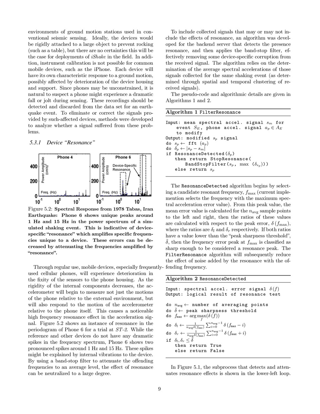
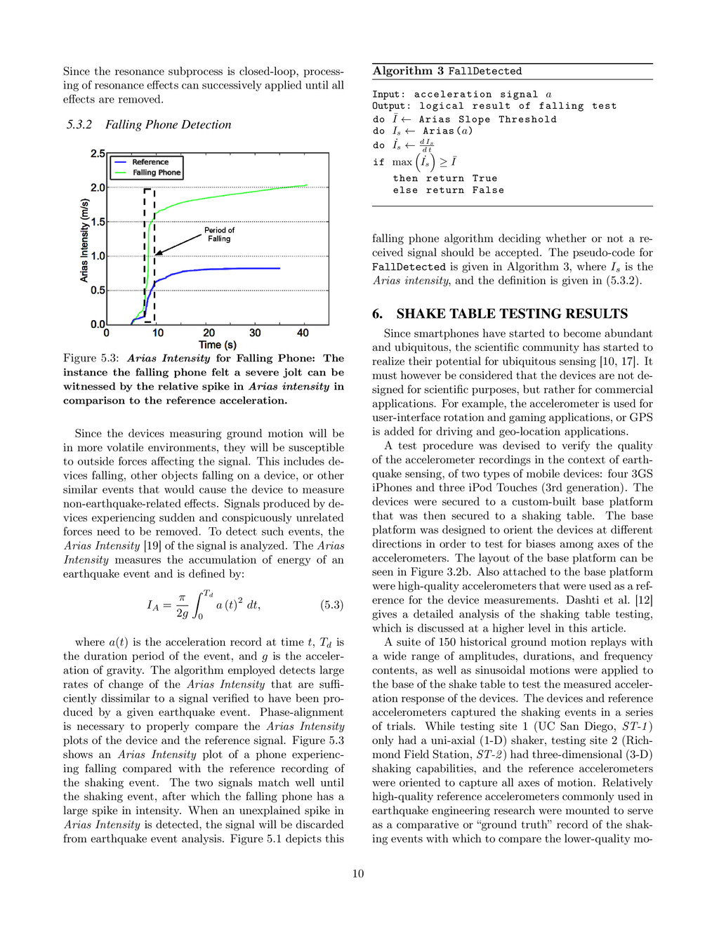
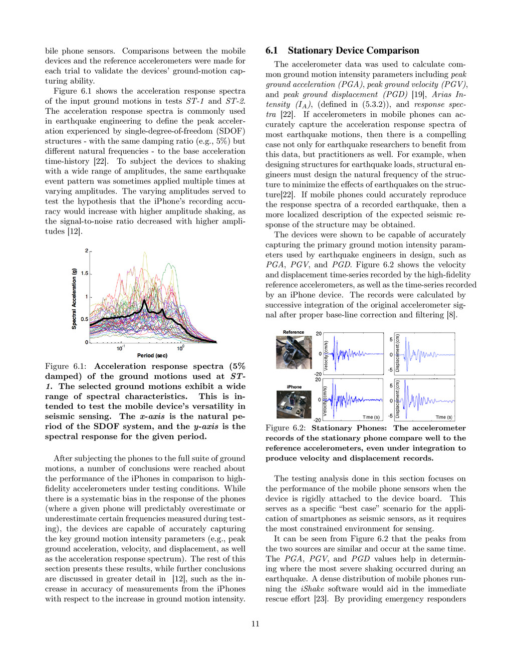
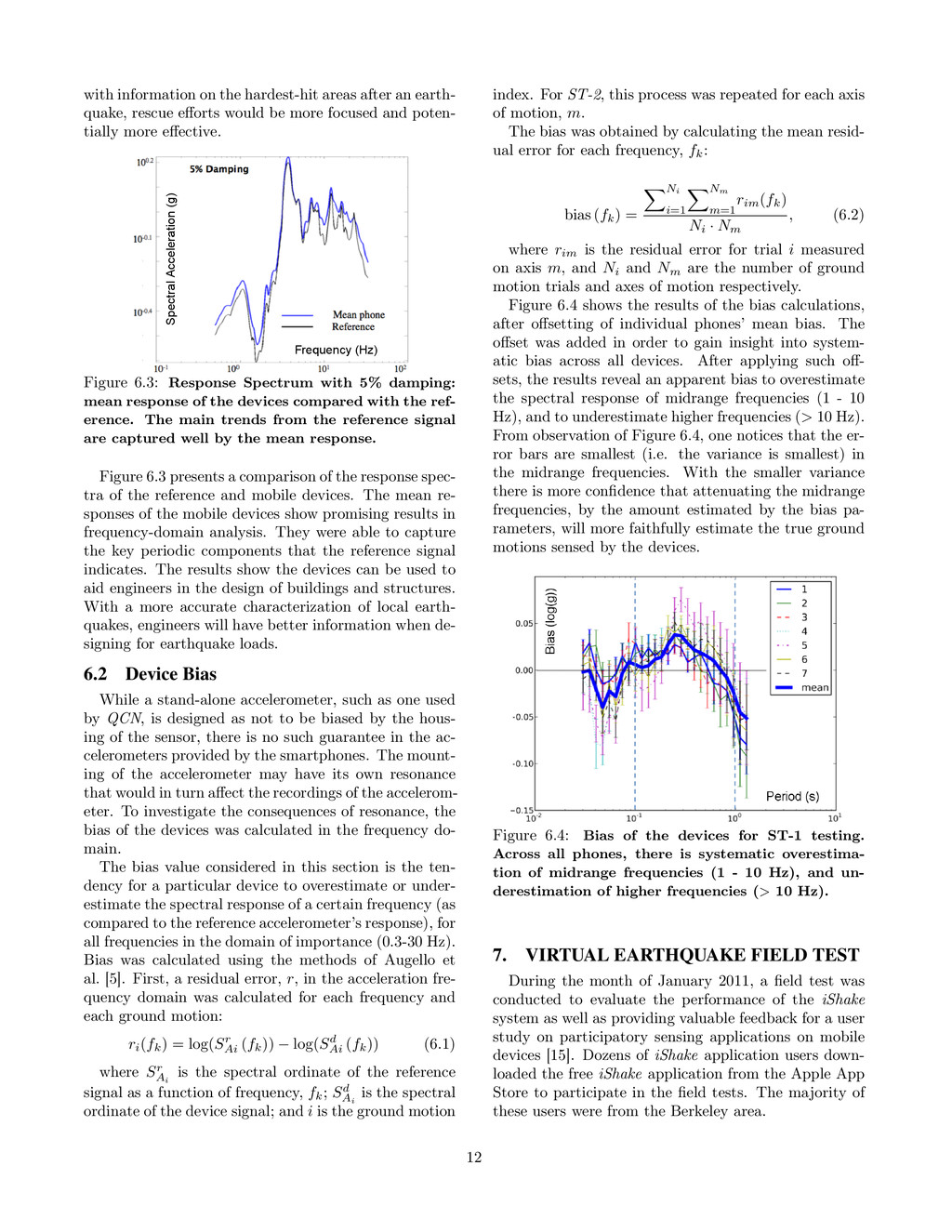
    Bossu, S. Gilles, G. Mazet-Roux, and F. Roussel. Citizen seismology: How to involve the public in earthquake response. Comparative Emergency Management: Examining Global and Regional Responses to Disasters, page 237, 2011. [10] J. Burke, D. Estrin, M. Hansen, A. Parker, N. Ramanathan, S. Reddy, and M.B. Srivastava. Participatory sensing. In World Sensor Web Workshop, pages 1–5. Citeseer, 2006. [11] E. Cochran, J. Lawrence, C. Christensen, and A. Chung. A novel strong-motion seismic network for community participation in earthquake monitoring. Instrumentation & Measurement Magazine, IEEE, 12(6):8–15, 2009. http://qcn.stanford.edu. [12] S. Dashti, J.D. Bray, J. Reilly, S. Glaser, and A. Bayen. ishake: Evaluating the reliability of mobile phones as seismic monitoring instruments (under review). Earthquake Spectra Journal, 2011. Earthquake Engineering Research Institute. [13] S. Dashti, J. Reilly, J.D. Bray, A.M. Bayen, S. Glaser, and E. Mari. ishake: Using personal devices to deliver rapid semi-quantitative earthquake shaking information. Technical report, GeoEngineering Report, Department of Civil and Environmental Engineering, University of California at Berkeley, 2011. [14] J. Eriksson, L. Girod, B. Hull, R. Newton, S. Madden, and H. Balakrishnan. The pothole patrol: using a mobile sensor network for road surface monitoring. In ACM MobiSys, 2008. [15] M. Ervasti, S. Dashti, J. Reilly, J.D. Bray, A.M. Bayen, and S.D. Glaser. ishake: Mobile phones as seismic sensors - user study findings. In Proceedings of 10th International Conference on Mobile and Ubiquitous Multimedia, Beijing, China, 2011. [16] D. Estrin. Mobile sensing systems: from ecosystems to human systems, 2009. [17] B. Hoh, M. Gruteser, R. Herring, J. Ban, D. Work, J.C. Herrera, A.M. Bayen, M. Annavaram, and Q. Jacobson. Virtual trip lines for distributed privacy-preserving traffic monitoring. In Proceeding of the 6th international conference on Mobile systems, applications, and services, pages 15–28. ACM, 2008. [18] B. Hull, V. Bychkovsky, Y. Zhang, K. Chen, M. Goraczko, A. Miu, E. Shih, H. Balakrishnan, and S. Madden. Cartel: a distributed mobile sensor computing system. In Proceedings of the 4th international conference on Embedded networked sensor systems, pages 125–138. ACM, 2006. [19] T. Lay and T.C. Wallace. Modern global seismology, volume 58. Academic Pr, 1995. [20] Y.N. Lien, H.C. Jang, and T.C. Tsai. A manet based emergency communication and information system for catastrophic natural disasters. In 2009 29th IEEE International Conference on Distributed Computing Systems Workshops, pages 412–417. IEEE, 2009. [21] U. Neumann, S. You, Y. Cho, J. Lee, and J. Park. Augmented reality tracking in natural environments. In International Symposium on Mixed Realities, volume 24, 1999. [22] N.M. Newmark and W.J. Hall. Earthquake spectra and design. Earth System Dynamics, 1, 1982. [23] D. Obenshain, K.M. Chandy, R. Chandy, R. Clayton, A. Krause, M. Olson, D. Rosenberg, and A. Tang. Community seismic network. [24] B.W. Parkinson, J.J. Spilker, P. Axelrad, and P. Enge. Global positioning system: Theory and applications volume ii. Progress in astronautics and aeronautics, 163, 1996. [25] G.R. Pickett. Acoustic character logs and their applications in formation evaluation. Journal of Petroleum Technology, 15(6):659–667, 1963. [26] D.J. Pines and P.A. Lovell. Conceptual framework of a remote wireless health monitoring system for large civil structures. Smart materials and Structures, 7:627, 1998. [27] T. Sakaki, M. Okazaki, and Y. Matsuo. Earthquake shakes twitter users: real-time event detection by social sensors. In Proceedings of the 19th international conference on World wide web, pages 851–860. ACM, 2010. [28] D.J. Wald, V. Quitoriano, T.H. Heaton, H. Kanamori, C.W. Scrivner, and C.B. Worden. Trinet" shakemaps": rapid generation of peak ground motion and intensity maps for earthquakes in southern california. Earthquake Spectra, 15:537–556, 1999. http://earthquake.usgs.gov/shakemap/. [29] H. Zhang, E. Horvitz, R.C. Miller, and D.C. Parkes. Crowdsourcing general computation. In ACM CHI 2011 Workshop on Crowdsourcing and Human Computation, 2011. 14
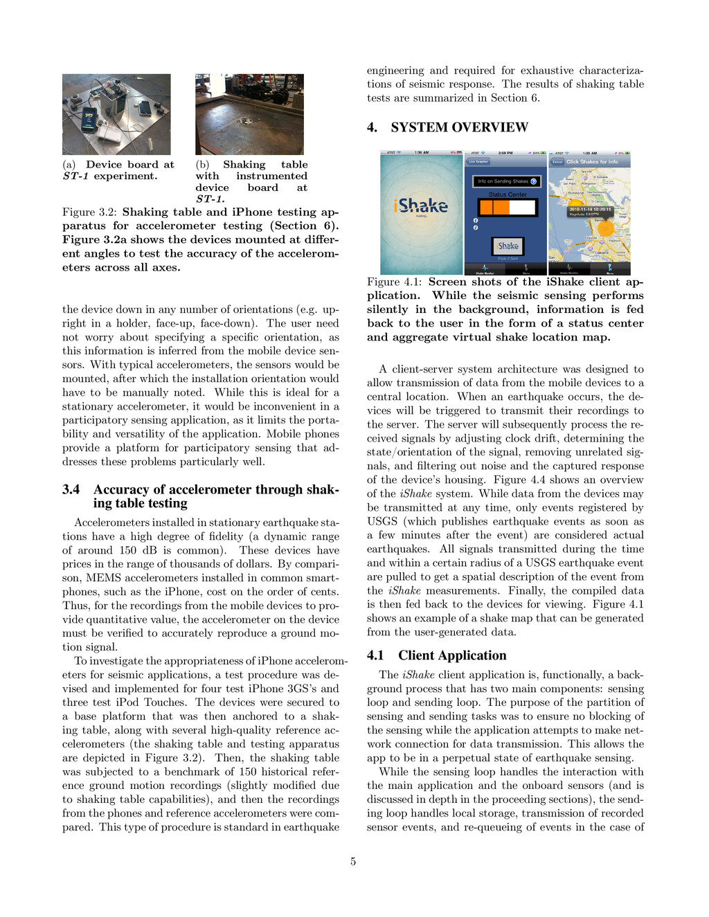
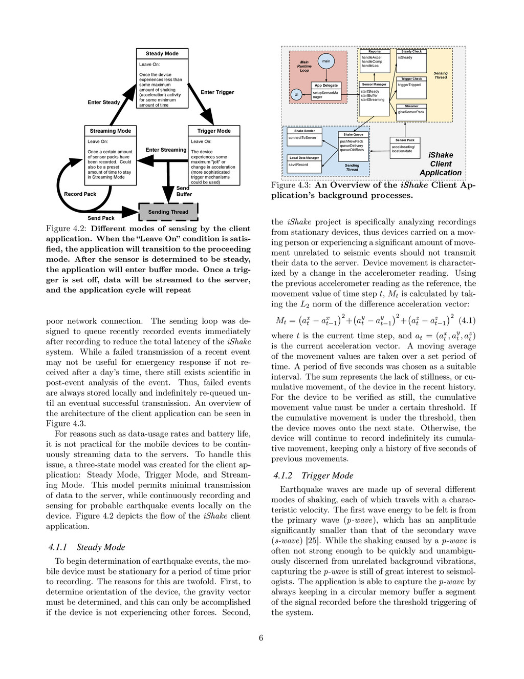
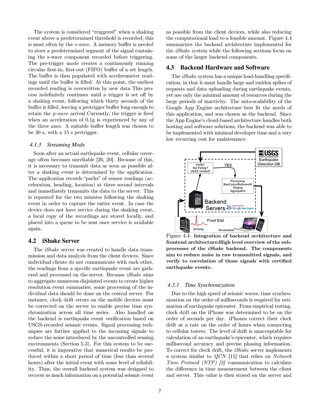