Upgrade to Pro — share decks privately, control downloads, hide ads and more …

An introduction to spatial microsimulation with R

Robin
May 08, 2014

An introduction to spatial microsimulation with R

These are the slides to accompany a two day course with the same name. See https://github.com/Robinlovelace/smsim-course for more information.

Robin

May 08, 2014
Tweet

More Decks by Robin

Other Decks in Research

Transcript

  1. An introduction to spatial microsimulation with R A Leeds Short

    Course funded by the CDRC Robin Lovelace, University of Leeds See http://robinlovelace.net/smsim-course/ 28th May 2015
  2. About this course • Aims to introduce both theory and

    practice of spatial microsimulation • Divided into 3 main parts: – Foundations – Creating spatial microdata with R – Applying the method • Housekeeping
  3. The agenda... and the handout • 9:30 – 11:00 Introduction

    – What is it? What it does. Reweighting • 11:15 – 13:00 Smsim in R – Loading the data, IPF in R • 13:30 – 16:30 An example – Preparing input data • 9:30 – 11:00 Analysis – Validation • 11:15 – 13:30 Extensions – Integerisation 1) Foundations 2) IPF in R 3) CakeMap / other
  4. Why do you need spatial microsimulation? I • To tackle

    the modifiable areal unit problem (MAUP) (Openshaw 1983) The world is like this: complex Administrative zones (“areal units”) look like this - a little arbitrary! Making it look (a bit) like this: oversimple!
  5. Why do you need spatial microsimulation? II As an input

    into agent based models (image is in the context of transport modelling – deterministic reweighting = spatial microsimulation) To create a synthetic population, also known as synthetic spatial microdata
  6. What is spatial microsimulation? I • A method for synthesising

    spatial microdata based on survey and areal input data (Lovelace and Ballas 2013)
  7. What is spatial microsimulation? II • A procedure to translate

    from 'wide' to 'long' data formats • Restrictive data anonymity regulations
  8. Applications – some examples • To estimate local smoking rates

    (Tomintz et al. 2008) • To investigate commuter patterns and model distributional impact of future scenarios (Lovelace et al. 2014) • Farmer participation in agri-environment schemes (Hynes et al. 2008)
  9. Validation • It's tricky – you'll generally only simulate things

    you do not know • But very important: possible to mislead with this technique • Internal validation: compare with prior expectations – is the model working OK? • External validation: compare with the real world
  10. References • Edwards, K. L., Clarke, G. P., Thomas, J.,

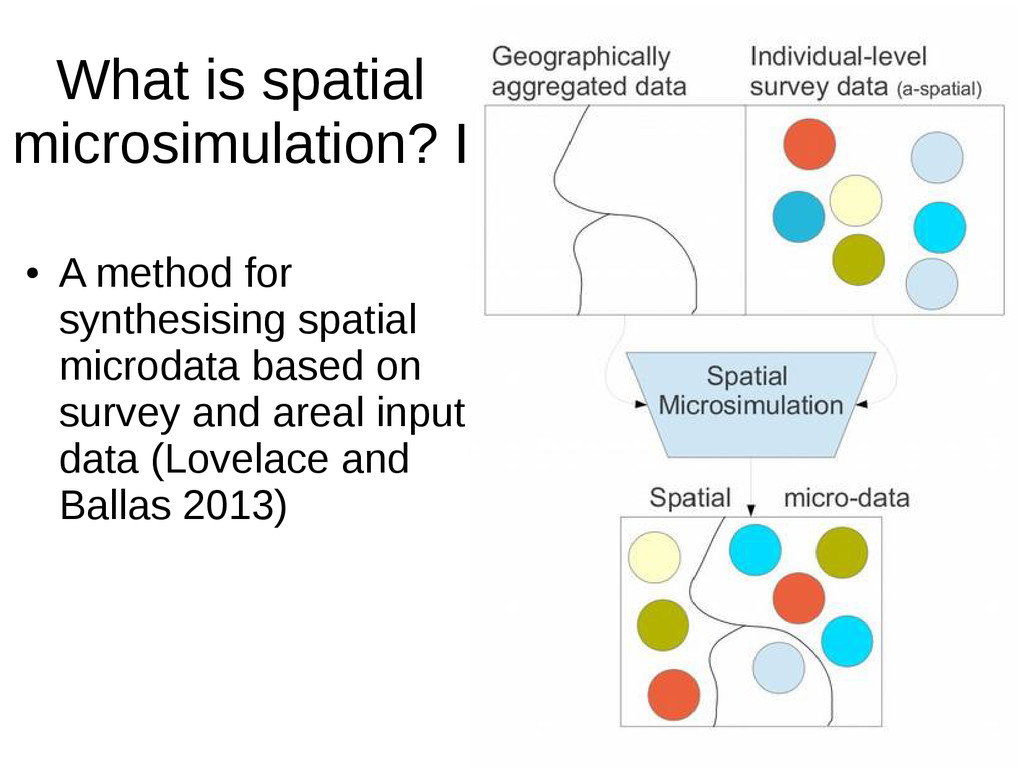
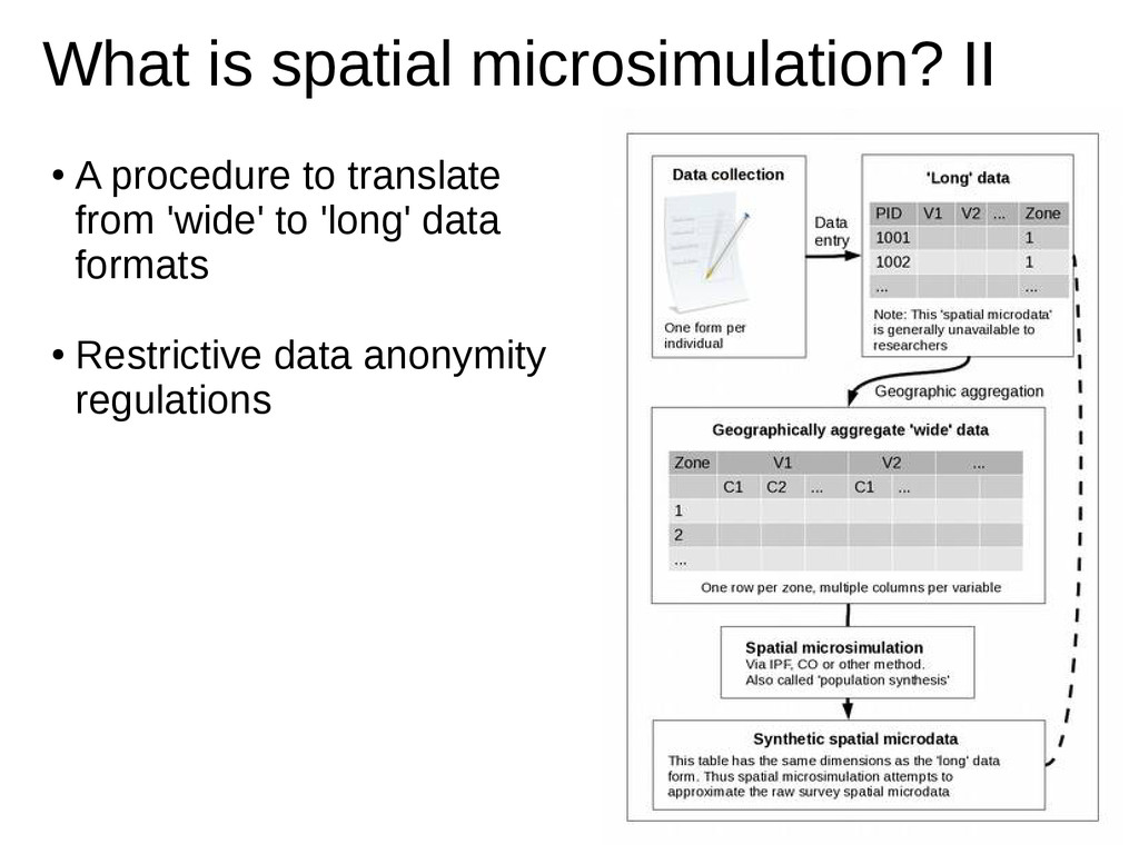
    & Forman, D. (2011). Internal and external validation of spatial microsimulation models: Small area estimates of adult obesity. Applied Spatial Analysis and Policy, 4(4), 281-300. (The importance of validation). • Hynes, S., Farrelly, N., Murphy, E., & O'Donoghue, C. (2008). Modelling habitat conservation and participation in agri-environmental schemes: a spatial microsimulation approach. Ecological economics, 66(2), 258-269. (Agricultural application). • Lovelace, R., Ballas, D., & Watson, M. (2013). A spatial microsimulation approach for the analysis of commuter patterns: from individual to regional levels. Journal of Transport Geography. (Policy-relevant application). • Lovelace, Robin, and Dimitris Ballas. ‘Truncate, replicate, sample’: A method for creating integer weights for spatial microsimulation. Computers, Environment and Urban Systems 41 (2013): 1-11. (Method). • Openshaw, S. (1983). The modifiable areal unit problem (Vol. 38). Norwich: Geo Books. • Tomintz, M. N., Clarke, G. P., & Rigby, J. E. (2008). The geography of smoking in Leeds: estimating individual smoking rates and the implications for the location of stop smoking services. Area, 40(3), 341-353. (Health application).