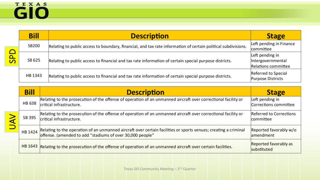
SB200 Rela>ng to public access to boundary, financial, and tax rate informa>on of certain poli>cal subdivisions. LeV pending in Finance commiXee SB 625 Rela>ng to public access to financial and tax rate informa>on of certain special purpose districts. LeV pending in Intergovernmental Rela>ons commiXee HB 1343 Rela>ng to public access to financial and tax rate informa>on of certain special purpose districts. Referred to Special Purpose Districts Bill Descrip+on Stage HB 638 Rela>ng to the prosecu>on of the offense of opera>on of an unmanned aircraV over correc>onal facility or cri>cal infrastructure. LeV pending in Correc>ons commiXee SB 395 Rela>ng to the prosecu>on of the offense of opera>on of an unmanned aircraV over correc>onal facility or cri>cal infrastructure. Referred to Correc>ons commiXee HB 1424 Rela>ng to the opera>on of an unmanned aircraV over certain facili>es or sports venues; crea>ng a criminal offense. (amended to add “stadiums of over 30,000 people” Reported favorably w/o amendment HB 1643 Rela>ng to the prosecu>on of the offense of opera>on of an unmanned aircraV over certain facili>es. Reported favorably as subs>tuted SPD UAV
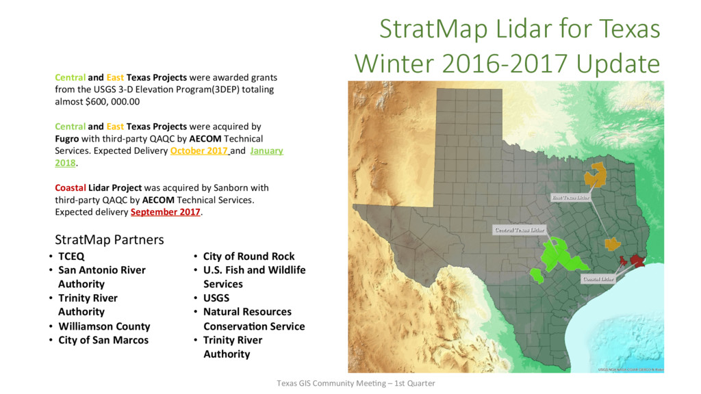
Texas Projects were awarded grants from the USGS 3-D Eleva>on Program(3DEP) totaling almost $600, 000.00 Central and East Texas Projects were acquired by Fugro with third-party QAQC by AECOM Technical Services. Expected Delivery October 2017 and January 2018. Coastal Lidar Project was acquired by Sanborn with third-party QAQC by AECOM Technical Services. Expected delivery September 2017. StratMap Partners • TCEQ • San Antonio River Authority • Trinity River Authority • Williamson County • City of San Marcos • City of Round Rock • U.S. Fish and Wildlife Services • USGS • Natural Resources Conserva+on Service • Trinity River Authority Texas GIS Community Mee>ng – 1st Quarter
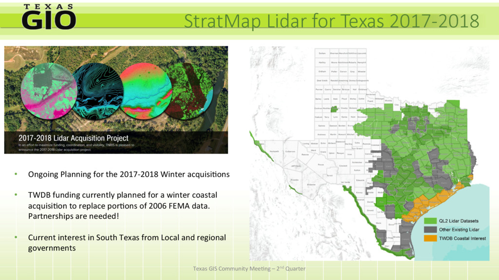
2017-2018 Winter acquisi>ons • TWDB funding currently planned for a winter coastal acquisi>on to replace por>ons of 2006 FEMA data. Partnerships are needed! • Current interest in South Texas from Local and regional governments Texas GIS Community Mee>ng – 2nd Quarter
• WMTS/WMS links • Automa>c Imagery Updates • Pilot program to end August 31, 2017 • Annual Cost Model now available STATE AGENCY $15,625 - $125,000 REGIONAL GOV $10,000 - $30,000 LOCAL GOV $6,000 - $24,000 Texas GIS Community Mee>ng – 2nd Quarter
be acquired Summer 2017 • Capital Area – To be acquired Winter 2017/18 • Smith/Gregg Coun>es – To be acquired Winter 2017/18 Texas GIS Community Mee>ng – 2nd Quarter
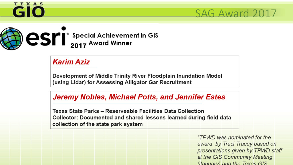
by Traci Tracey based on presentations given by TPWD staff at the GIS Community Meeting Karim Aziz Development of Middle Trinity River Floodplain Inundation Model (using Lidar) for Assessing Alligator Gar Recruitment Jeremy Nobles, Michael Potts, and Jennifer Estes Texas State Parks – Reserveable Facilities Data Collection Collector: Documented and shared lessons learned during field data collection of the state park system