Upgrade to Pro — share decks privately, control downloads, hide ads and more …

20250831JCA

 20250831JCA

* 日本地図学会2025年度定期大会
* S-02特別セッション「デジタル時代の地図リテラシー再考」

Avatar for Toshikazu SETO

Toshikazu SETO

August 31, 2025
Tweet

More Decks by Toshikazu SETO

Other Decks in Research

Transcript

  1. 2025/08/31 ⽇本地図学会2025年度定期⼤会 1 「地理情報科学と技術の知識体系」改訂版の内容 分析から探る現代の地図・GIS教育ニーズ 瀬⼾ 寿⼀ A02 KOMAZAWA UNIVERSITY

    Visual Identity Guidelines Ϋʴ࿨จϩΰλΠϓ ,ϚʔΫʴ࿨จϩΰλΠϓͷ૊Έ߹Θͤ ͸ɺ ࠨͷछͰ͢ɻ ԣ جຊܗͱ͠ɺ ༏ઌతʹ࢖༻͠·͢ɻ ԣ ϫϯϙΠϯτͳͲɺ ʮԣʯ ͕഑ஔ͠ʹ͍͘ ৔߹ʹ࢖༻͠·͢ɻ ॎ ॎܕαΠϯͳͲɺ ࡉ௕͍഑ஔʹ࢖༻͠·͢ɻ ඞͣϚελʔσʔλΛ࢖༻͍ͯͩ͘͠͞ɻ ࠨهҎ֎ͷ૊Έ߹ΘͤΛ࡞੒͠ͳ͍Ͱ ͍ͩ͘͞ɻ ܗʣ ϙΠϯτ౳ʣ ॎ 駒澤⼤学⽂学部地理学科・准教授 東京⼤学空間情報科学研究センター(CSIS)・特任准教授 本研究は,JSPS科研費(21H00627・22H00764・22K18505・ 24K15662)の助成を受けて⾏ったものである.
  2. 2025/08/31 ⽇本地図学会2025年度定期⼤会 2 研究の背景・⽬的 • ⽶国UCGISで整備された「GIS&Tの知識体系(Body of Knowledge: BoK)」が,2016年以降より社会的ニーズ 等を踏まえて抜本的な改訂を実施中

    – WebGISの普及・SNSと位置情報サービスの融合など、 地理空間情報を活⽤する新たなニーズが多分野へ展開 • ⽇本でも2010年代にかけて,BoKの整備(貞広ほか, 2012)や教科書の作成(浅⾒ほか,2015),実習⽤教材 の開発(⼭内ほか,2019)などが進んでいるが,BoK⾃体 は⼤きく⾒直されていない現状 ①⽶国版BoKの開発経緯と改訂版の内容を整理すること ②記載事項に関するコンテンツ分析,特にGIS&T分野で近年 重要とされているテーマや項⽬・キーワード等の傾向を明ら かにすること
  3. 2025/08/31 ⽇本地図学会2025年度定期⼤会 3 GIScience and Technology Body of Knowledge (GIS&T

    BoK) 1st edition(2006) • 専⾨家および専⾨家を⽬指す ⼈々が何を知り、何ができるよ うになる必要があるかを明記し た包括的な「知識体系」が必要 (ACM/IEEE, 2001) • 10分野(Area)・73単元 (Unit),329トピックで構成 • BoKの主な⽤途︓①カリキュラ ムの計画,②教育プログラムの 評価,③教育プログラム間の連 携,④カリキュラムの改訂,⑤ プログラム認定 • ⑤については派⽣してNGAに よる防衛関連のカリキュラム開 発(当時)が始まった点を⽰唆 DiBiase et al. (2007) Cartography and Geographic Information Science, 34:2, 113-120. ▼GIS&Tの教育段階とGIS専⾨家とし て果たすべき役割(スキル) and assessment methods to meet these aims and objectives” (Unwin 1990, p. 4). Multiple pathways to diverse outcomes: Recognizing the multidisciplinary nature of the field, the Task Force envisioned an • primary and secondary schools through post baccalaureate and professional education). Figure 2. The GIS&T education infrastructure. Columns represent sectors of formal education that span a lifetime of learning. Rows correspond to levels of competency as described in Marble (1998). Informal education spans the learner’s lifetime in parallel with formal education. [© 2006 Association of American Geographers and University Consortium for Geographic Information Science. Used by permission. All rights reserved.] →後にUSGIF(The United States Geospatial Intelligence Foundation)設⽴と GEOINTに関する独⽴したカリキュラム化へ
  4. 2025/08/31 ⽇本地図学会2025年度定期⼤会 4 GIS&T BoK (初版)の実例 database • Set type

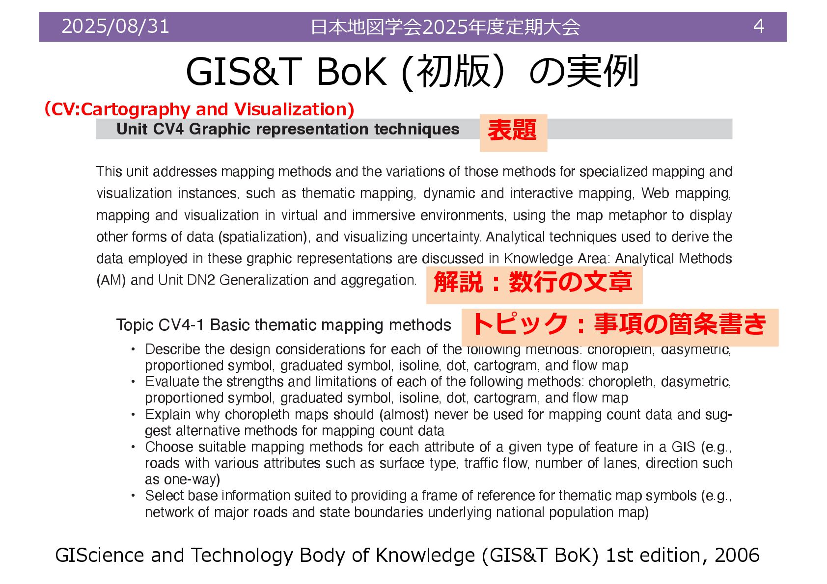
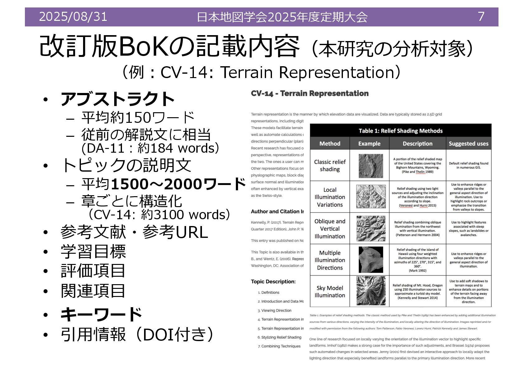
    font, size, style, and color for labels on a map by applying basic typography design prin- ciples • Create a set of mapping problems that can be used to illustrate point, line, and area label con- ventions for placing text on maps • Solve a labeling problem for a dense collection of features on a map using minimal leader lines Unit CV4 Graphic representation techniques This unit addresses mapping methods and the variations of those methods for specialized mapping and visualization instances, such as thematic mapping, dynamic and interactive mapping, Web mapping, mapping and visualization in virtual and immersive environments, using the map metaphor to display other forms of data (spatialization), and visualizing uncertainty. Analytical techniques used to derive the data employed in these graphic representations are discussed in Knowledge Area: Analytical Methods (AM) and Unit DN2 Generalization and aggregation. Topic CV4-1 Basic thematic mapping methods • Describe the design considerations for each of the following methods: choropleth, dasymetric, proportioned symbol, graduated symbol, isoline, dot, cartogram, and flow map • Evaluate the strengths and limitations of each of the following methods: choropleth, dasymetric, proportioned symbol, graduated symbol, isoline, dot, cartogram, and flow map • Explain why choropleth maps should (almost) never be used for mapping count data and sug- gest alternative methods for mapping count data • Choose suitable mapping methods for each attribute of a given type of feature in a GIS (e.g., roads with various attributes such as surface type, traffic flow, number of lanes, direction such as one-way) • Select base information suited to providing a frame of reference for thematic map symbols (e.g., network of major roads and state boundaries underlying national population map) GIScience and Technology Body of Knowledge (GIS&T BoK) 1st edition, 2006 表題 解説︓数⾏の⽂章 トピック︓事項の箇条書き (CV:Cartography and Visualization)
  5. 2025/08/31 ⽇本地図学会2025年度定期⼤会 5 GIS&T BoK (2016年改訂版)の概要 2016年〜︓改訂版の開発着⼿・2023年〜︓オンライン化 • 420教材*のうち242教材を対象にコンテンツ分析 *:2025年1⽉時点で,178教材はタイトルのみ

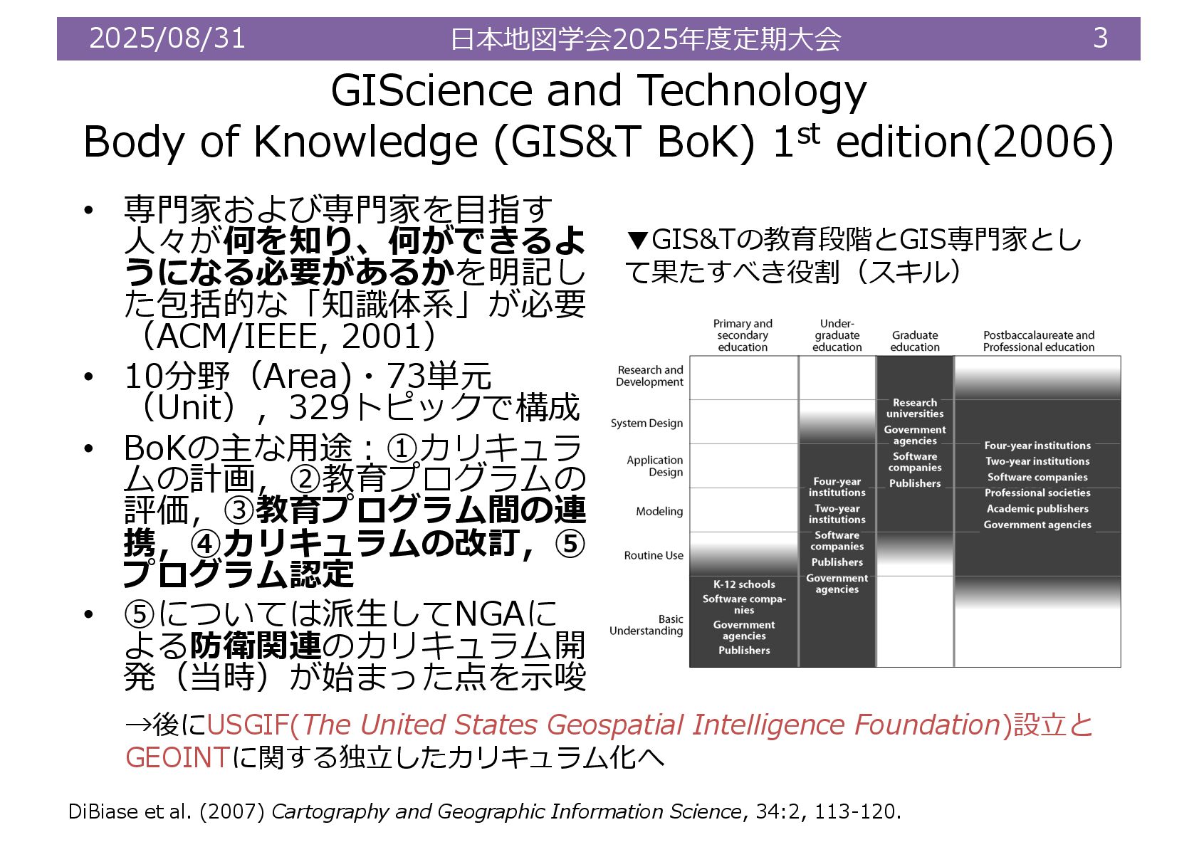
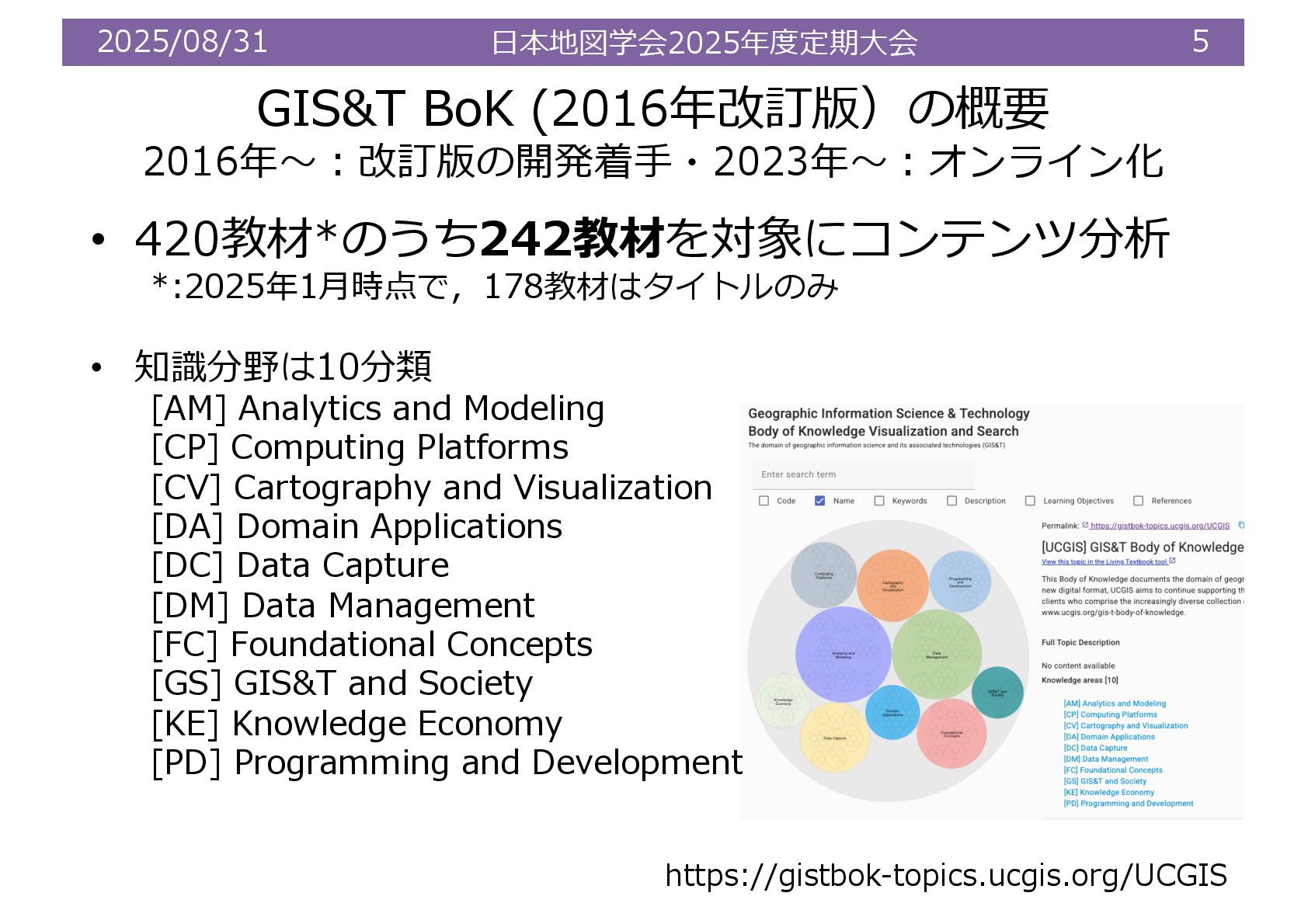
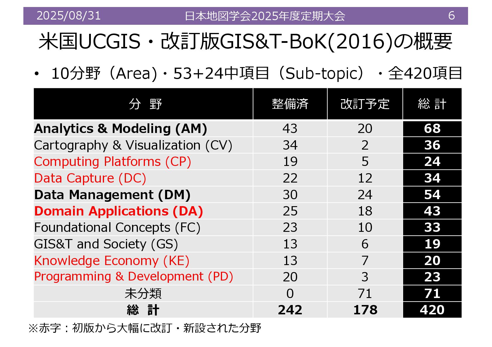
    • 知識分野は10分類 [AM] Analytics and Modeling [CP] Computing Platforms [CV] Cartography and Visualization [DA] Domain Applications [DC] Data Capture [DM] Data Management [FC] Foundational Concepts [GS] GIS&T and Society [KE] Knowledge Economy [PD] Programming and Development https://gistbok-topics.ucgis.org/UCGIS
  6. 2025/08/31 ⽇本地図学会2025年度定期⼤会 6 ⽶国UCGIS・改訂版GIS&T-BoK(2016)の概要 分 野 整備済 改訂予定 総 計

    Analytics & Modeling (AM) 43 20 68 Cartography & Visualization (CV) 34 2 36 Computing Platforms (CP) 19 5 24 Data Capture (DC) 22 12 34 Data Management (DM) 30 24 54 Domain Applications (DA) 25 18 43 Foundational Concepts (FC) 23 10 33 GIS&T and Society (GS) 13 6 19 Knowledge Economy (KE) 13 7 20 Programming & Development (PD) 20 3 23 未分類 0 71 71 総 計 242 178 420 • 10分野(Area)・53+24中項⽬(Sub-topic)・全420項⽬ ※⾚字︓初版から⼤幅に改訂・新設された分野
  7. 2025/08/31 ⽇本地図学会2025年度定期⼤会 7 改訂版BoKの記載内容(本研究の分析対象) (例︓CV-14: Terrain Representation) • アブストラクト –

    平均約150ワード – 従前の解説⽂に相当 (DA-11︓約184 words) • トピックの説明⽂ – 平均1500〜2000ワード – 章ごとに構造化 (CV-14: 約3100 words) • 参考⽂献・参考URL • 学習⽬標 • 評価項⽬ • 関連項⽬ • キーワード • 引⽤情報(DOI付き)
  8. 2025/08/31 ⽇本地図学会2025年度定期⼤会 8 アブストラクト内に使われている単語のテキスト分析 *: Data, Spatial, GIS, Geospatial, Geographic,

    Informationを除く • 論⽂中では直接扱わなかった分析 • Used (2,358)やApplication (1924)が分野全般に多い傾向。Web(1,930)はCVや PD内で,MapやDesignはCV内で多く⽤いられている
  9. 2025/08/31 ⽇本地図学会2025年度定期⼤会 9 キーワードの頻度(使⽤回数20以上) Keywords/分野 AM CP CV DA DC

    DM FC GS KE PD total programming 28 28 distance 15 1 9 25 basic analytical methods 24 24 enterprise GIS 5 14 5 24 spatial patterns 17 7 24 spatial statistics 18 2 2 22 time 5 1 16 22 spatial analysis 13 4 4 21 development 20 20 raster 5 3 5 7 20 • キーワードについては,従来の空間解析に関わる⽤語が⾮常に多く,「距離」・「空間パター ン」・「空間統計」など分析&モデリング(AM)に関連して多い傾向 • 他⽅,使⽤回数最多の「プログラミング」は,プログラム&開発(PD)のみで利⽤ • Enterprise GISやtime(時間)など,応⽤的側⾯も重要視 N=436
  10. 2025/08/31 ⽇本地図学会2025年度定期⼤会 10 学習成果の頻出単語の特徴(使⽤回数50以上) Keywords/分野 AM CP CV DA DC

    DM FC GS KE PD total Difference/Different 33 10 37 13 18 15 16 4 3 12 161 Model 65 3 3 6 2 44 6 4 8 2 143 Map(s) 10 5 108 4 2 5 1 2 1 138 Identify 7 3 22 19 7 6 8 6 6 6 90 Compare 15 5 18 5 8 8 7 2 1 1 70 Define 11 6 5 5 4 15 12 4 2 6 70 Types 7 2 13 2 6 7 8 2 5 5 57 Analysis 23 6 3 10 2 2 4 3 2 1 56 Design 3 38 2 1 1 8 1 54 Contrast 11 2 16 4 6 5 5 2 1 52 Gist 1 5 14 3 9 10 9 51 • 「Difference」(161回)、次いで「Model」(143回)、「Map」(138回)が続く結果 • 単純な知識の習得を超えて、⽐較・分析・評価といった⾼次の思考能⼒の育成が⽬標とされ ていることを⽰唆。特に「Compare」(70回)や「Identify」(90回)といった単語は、批 判的思考と分析的アプローチが重視されている︖ N=1161
  11. 2025/08/31 ⽇本地図学会2025年度定期⼤会 11 [PD-05-011] Python for GIS https://gistbok-ltb.ucgis.org/page/10/concept/2879 • 概要︓Pythonを使った開発の概要

    や主にオープンソースツールの紹介 –Computing Platforms (CP)やData Management(DM)とのつながりも • 到達⽬標 – GIS科学におけるプログラミング の役割を説明できる。 – 異なるPython GIS開発モードを 説明できる。 – 現在のPython GISプログラミン グに精通すること • 評価項⽬ – Python を使⽤した GIS 開発の 2 つの主なモデルは何か – GIS における Python プログラミ ングの使⽤例の説明Pythonにお ける GISの処理と分析範囲の説明
  12. 2025/08/31 ⽇本地図学会2025年度定期⼤会 12 [GS-02-024] Citizen Science with GIS&T https://gistbok-ltb.ucgis.org/page/30/concept/9476 •

    概要︓シチズンサイエンスを通じて、地域社会の意思決定者に影響を与え、 様々な問題に関する⼤規模なエビデンス収集を⽀援するのに役⽴つ可能性 を⽰唆。プロジェクト設計・ツール・データ品質評価などを説明 • 到達⽬標 – 参加者がプロジェクトに参加する際の潜在的な動機(内発的および外発的動 機)について議論すること – ⼈々に影響を与える可能性のある肯定的・否定的な側⾯(デジタルデバイド の問題、意図的な誤情報)について議論すること • データに関連する潜在的 なデータ品質問題への対 処⽅法と、収集された データの価値(認知度と ⽀援の向上、データ収集 の規模)について議論す ること
  13. 2025/08/31 ⽇本地図学会2025年度定期⼤会 14 GIS倫理(Ethics) [GS-02-011] Professional and Practical Ethics of

    GIS&T [GS-02-012] Ethics for Certified Geospatial Professionals • 概要 – 不正確な地図やデータの取扱い、データの知的財産について – モンモニア「地図の恣意性」やGIS実践者としてのモラル(差別的な地図や プライバシー侵害に関わる地図作成)への警鐘など、リテラシーに関する 記述も • 到達⽬標 – 倫理に関する事例を分析し、GIS の専⾨的実践における倫理的課題を推論 できる。 – 専⾨的・実践的な視点(内部主義)と批判的な視点(外部主義)を⽐較対 照できる。 – 倫理的課題に対して複数の解決策を提⽰することができる。 • 評価項⽬ – GIS の専⾨家は倫理について何を知っておくべきか︖ – GIS教育者は倫理について何を教えるべきか︖ – GIS倫理を教える最善の⽅法は︖ →⽶国科学アカデミー︓GIScienceの3E(Ethics, Empathy, Equity)に 関する展望論⽂も(Nelson et al., 2022) https://gistbok-ltb.ucgis.org/page/10/concept/2835 Nelson TA, Goodchild MF, Wright DJ (2022b) Accelerating ethics, empathy, and equity in geographic information science. PNAS 119(19): 1–12.
  14. 2025/08/31 ⽇本地図学会2025年度定期⼤会 15 結論と今後の研究課題 • 現在のBoKは,従来の「空間分析&モデリング」の内容 を基本としながら,新しい内容としてWebを前提とした データ利⽤やアプリケーション,組織論へ⼤きく拡張 • プログラミング(Python)やコンピューティング環境(プ

    ラットフォーム)に関する記事の追加 • 社会情勢を踏まえた内容(ジオコミュニティや倫理, 災 害対応、GEOINTなど)の充実 • ⼤きな変化︓①学習⽬標や評価項⽬の充実,②トピック ス間のつながりの明確化 • 項⽬ごとの学習⽬標や評価項⽬(問い)は,GIS教育で何を学ぶか を再定義するうえでより精査する必要 • ⽇本のGIS科⽬(実習科⽬が恐らく多い)どこまで適⽤可能か • GIS実習オープン教材(⼭内ほか,2019)の継続的な更新・発展 + 実情を踏まえた⽇本版BoKの抜本的な更新も視野にいれる必要