Upgrade to Pro
— share decks privately, control downloads, hide ads and more …
Speaker Deck
Sign up for free
Menu
Search
Features
All features
Private URLs
Password Protection
Custom URLS
Scheduled publishing
Remove Branding
Restrict embedding
Deck Collections
Notes
Features
All features
Private URLs
Password Protection
Custom URLS
Scheduled publishing
Remove Branding
Restrict embedding
Deck Collections
Notes
Explore
Featured decks
Featured speakers
Programming
Technology
Storyboards
Explore
Featured decks
Featured speakers
Programming
Technology
Storyboards
Pricing
Search
Sign in
Sign up for free
所要時間のヒートマップを作成する
Search
nonki1974
December 08, 2018
Technology
620
0
Share
Embed
Copy iframe code
Copy JS code
Copy link
Start on current slide
所要時間のヒートマップを作成する
nonki1974
December 08, 2018
More Decks by nonki1974
See All by nonki1974
GTFS with Tidytransit package
nonki1974
0
350
TokyoR#84_Rexams
nonki1974
0
240
都道府県別焼き鳥屋ランキングの作成
nonki1974
1
940
Introduction to R
nonki1974
0
400
Introduction to dplyr
nonki1974
0
570
Introduction to ggplot2
nonki1974
1
560
Analyzing PSB tracks with R
nonki1974
0
640
introduction to fukuoka.R @ Fukuoka.LT
nonki1974
0
85
gtfsr package @ fukuoka.R #11
nonki1974
0
370
Other Decks in Technology
See All in Technology
実践!Cloud Run ハンズオン!! / Cloud Run handson
y0hgi
0
240
おそらく日本で唯一のDevRelインターン生として
husengs7
0
180
go-sqletch
moznion
0
140
転んだ話が背中を預ける理由になる / A_story_about_falling_down_gives_you_a_reason_to_watch_each_other_s_backs.pdf
pauli
3
360
ゲームのリアルタイム通信から見た QUIC と MoQ
segadevtech
0
110
DGX Spark でどこまでハッキングができるのか?
kash1064
0
950
FactoryBotアンチパターン / factory_bot anti-patterns
toshimaru
0
150
分析の民主化を支えるメタデータ整備の実践
kakehashi
PRO
4
1.3k
Kiro Crewをはじめよう
kizawa2020
1
140
分析AIエージェントを育てる、動く環境を育てる
codatum
1
1k
触りたくないデータに、どう触るか AI時代のRBACアクセスガバナンス
ivry_presentationmaterials
0
130
More Freedom on the Same Shared GPU Cluster: A Small Team’s Experience with vCluster
nttcom
0
160
Featured
See All Featured
How to audit for AI Accessibility on your Front & Back End
davetheseo
0
600
WENDY [Excerpt]
tessaabrams
14
40k
Building a Modern Day E-commerce SEO Strategy
aleyda
45
9.2k
The State of eCommerce SEO: How to Win in Today's Products SERPs - #SEOweek
aleyda
2
12k
brightonSEO & MeasureFest 2025 - Winning Strategies for Black Friday CRO & PPC - Christian Goodrich
cargoodrich
3
870
職位にかかわらず全員がリーダーシップを発揮するチーム作り / Building a team where everyone can demonstrate leadership regardless of position
madoxten
69
67k
Un-Boring Meetings
codingconduct
0
450
Visualizing Your Data: Incorporating Mongo into Loggly Infrastructure
mongodb
50
10k
Prompt Engineering for Job Search
mfonobong
0
500
AI in Enterprises - Java and Open Source to the Rescue
ivargrimstad
0
1.5k
How to Create Impact in a Changing Tech Landscape [PerfNow 2023]
tammyeverts
56
3.5k
Learning to Love Humans: Emotional Interface Design
aarron
275
41k
Transcript
所要時間のヒートマップを 作成する google directions API & googleway package Tomokazu FUJINO
@ R研究集会2018 LT December 28, 2018
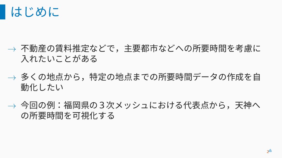
はじめに → 不動産の賃料推定などで,主要都市などへの所要時間を考慮に 入れたいことがある → 多くの地点から,特定の地点までの所要時間データの作成を自 動化したい → 今回の例:福岡県の 3
次メッシュにおける代表点から,天神へ の所要時間を可視化する 2
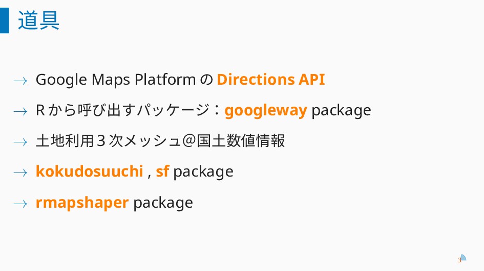
道具 → Google Maps Platform の Directions API → R
から呼び出すパッケージ:googleway package → 土地利用 3 次メッシュ@国土数値情報 → kokudosuuchi , sf package → rmapshaper package 3
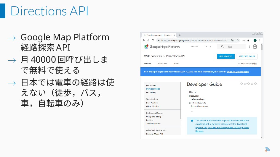
Directions API → Google Map Platform 経路探索 API → 月
40000 回呼び出しま で無料で使える → 日本では電車の経路は使 えない(徒歩,バス, 車,自転車のみ) 4
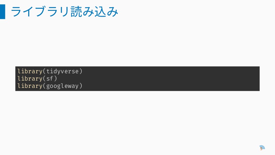
ライブラリ読み込み library(tidyverse) library(sf) library(googleway) 5
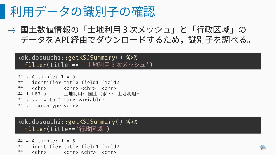
利用データの識別子の確認 → 国土数値情報の「土地利用 3 次メッシュ」と「行政区域」の データを API 経由でダウンロードするため,識別子を調べる。 kokudosuuchi::getKSJSummary() %>%
filter(title == "土地利用 3 次メッシュ") ## # A tibble: 1 x 5 ## identifier title field1 field2 ## <chr> <chr> <chr> <chr> ## 1 L03-a 土地利用~ 国土(水・~ 土地利用~ ## # ... with 1 more variable: ## # areaType <chr> kokudosuuchi::getKSJSummary() %>% filter(title=="行政区域") ## # A tibble: 1 x 5 ## identifier title field1 field2 ## <chr> <chr> <chr> <chr> 6
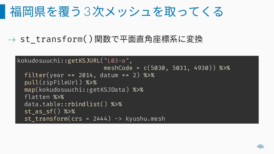
福岡県を覆う3次メッシュを取ってくる → st_transform() 関数で平面直角座標系に変換 kokudosuuchi::getKSJURL("L03-a", meshCode = c(5030, 5031, 4930))
%>% filter(year == 2014, datum == 2) %>% pull(zipFileUrl) %>% map(kokudosuuchi::getKSJData) %>% flatten %>% data.table::rbindlist() %>% st_as_sf() %>% st_transform(crs = 2444) -> kyushu.mesh 7
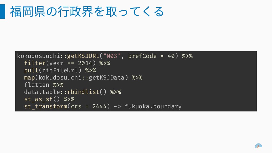
福岡県の行政界を取ってくる kokudosuuchi::getKSJURL("N03", prefCode = 40) %>% filter(year == 2014) %>%
pull(zipFileUrl) %>% map(kokudosuuchi::getKSJData) %>% flatten %>% data.table::rbindlist() %>% st_as_sf() %>% st_transform(crs = 2444) -> fukuoka.boundary 8
メッシュの切り出しと中心点の計算 福岡県の行政界でメッシュを切り出す st_join(kyushu.mesh, fukuoka.boundary, join = st_intersects) %>% filter(!is.na(N03_007)) ->
fukuoka.mesh メッシュの中心点を計算して,出発点として使う fukuoka.mesh %>% mutate(center = st_centroid(geometry)) %>% st_set_geometry("center") %>% st_transform(crs = 4326) %>% mutate(x = st_coordinates(center)[,2], y = st_coordinates(center)[,1]) -> fukuoka.centroid 9
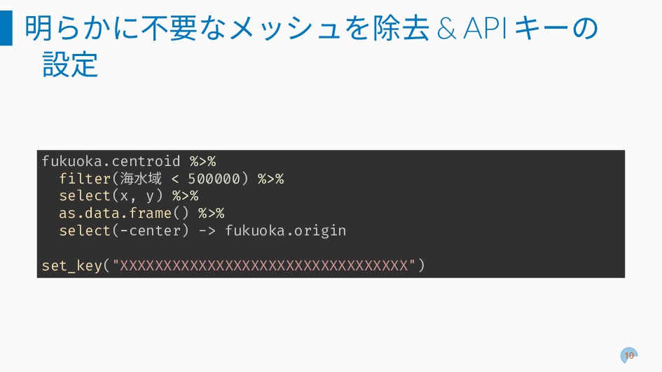
明らかに不要なメッシュを除去 & APIキーの 設定 fukuoka.centroid %>% filter(海水域 < 500000) %>%
select(x, y) %>% as.data.frame() %>% select(-center) -> fukuoka.origin set_key("XXXXXXXXXXXXXXXXXXXXXXXXXXXXXXXXX") 10
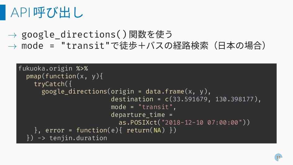
API呼び出し → google_directions() 関数を使う → mode = "transit"で徒歩+バスの経路検索(日本の場合) fukuoka.origin %>%
pmap(function(x, y){ tryCatch({ google_directions(origin = data.frame(x, y), destination = c(33.591679, 130.398177), mode = "transit", departure_time = as.POSIXct("2018-12-10 07:00:00")) }, error = function(e){ return(NA) }) }) -> tenjin.duration 11
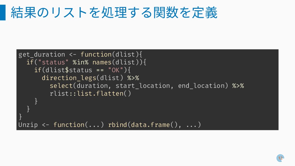
結果のリストを処理する関数を定義 get_duration <- function(dlist){ if("status" %in% names(dlist)){ if(dlist$status == "OK"){
direction_legs(dlist) %>% select(duration, start_location, end_location) %>% rlist::list.flatten() } } } Unzip <- function(...) rbind(data.frame(), ...) 12
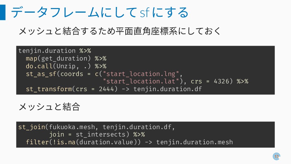
データフレームにしてsfにする メッシュと結合するため平面直角座標系にしておく tenjin.duration %>% map(get_duration) %>% do.call(Unzip, .) %>% st_as_sf(coords
= c("start_location.lng", "start_location.lat"), crs = 4326) %>% st_transform(crs = 2444) -> tenjin.duration.df メッシュと結合 st_join(fukuoka.mesh, tenjin.duration.df, join = st_intersects) %>% filter(!is.na(duration.value)) -> tenjin.duration.mesh 13
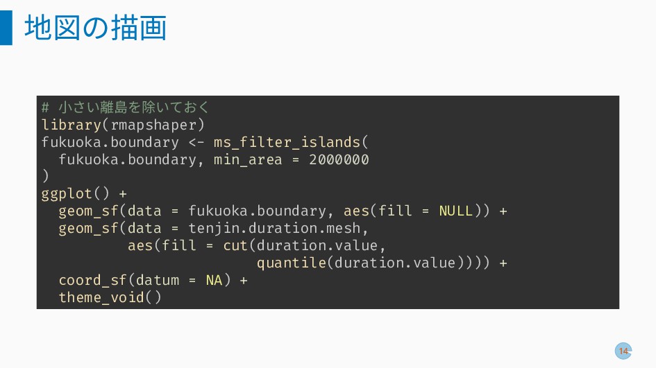
地図の描画 # 小さい離島を除いておく library(rmapshaper) fukuoka.boundary <- ms_filter_islands( fukuoka.boundary, min_area =
2000000 ) ggplot() + geom_sf(data = fukuoka.boundary, aes(fill = NULL)) + geom_sf(data = tenjin.duration.mesh, aes(fill = cut(duration.value, quantile(duration.value)))) + coord_sf(datum = NA) + theme_void() 14
地図の描画 fill (445,4.66e+03] (4.66e+03,6.66e+03] (6.66e+03,8.36e+03] (8.36e+03,3.73e+04] NA 15
車の場合: mode="driving" fill (281,3e+03] (3e+03,3.67e+03] (3.67e+03,4.69e+03] (4.69e+03,1.42e+04] NA 16


 nonki1974
 y0hgi
y0hgi
 husengs7
 moznion
 pauli
pauli
 segadevtech
 kash1064
 toshimaru
 kakehashi
 kizawa2020
.png) codatum
codatum
 ivry_presentationmaterials
 nttcom
 davetheseo
 tessaabrams
 aleyda
.jpg) cargoodrich
cargoodrich
 madoxten
 codingconduct
 mongodb
 mfonobong
 ivargrimstad
 tammyeverts
 aarron


![地図の描画 fill (445,4.66e+03] (4.66e+03,6.66e+03] (6.66e+03,8.36e+03] (8.36e+03,3.73e+04] NA 15](https://files.speakerdeck.com/presentations/209863fa32084aa1a713f2909e4715dc/slide_14.jpg)
![車の場合: mode="driving" fill (281,3e+03] (3e+03,3.67e+03] (3.67e+03,4.69e+03] (4.69e+03,1.42e+04] NA 16](https://files.speakerdeck.com/presentations/209863fa32084aa1a713f2909e4715dc/slide_15.jpg)