Upgrade to Pro — share decks privately, control downloads, hide ads and more …

Day2-1500-OpenStreetMapデータを用いた触地図自動作成システムの開発 ―縮尺に応じた表示内容変更機能の実装―

sotm2017
September 01, 2017

Day2-1500-OpenStreetMapデータを用いた触地図自動作成システムの開発 ―縮尺に応じた表示内容変更機能の実装―

sotm2017

September 01, 2017
Tweet

More Decks by sotm2017

Other Decks in Research

Transcript

  1. Development of a Tactile Map Automated Creation System Using OpenStreetMap

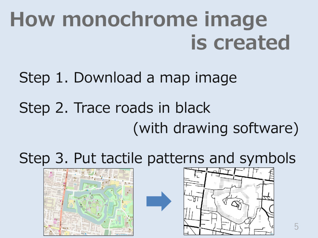
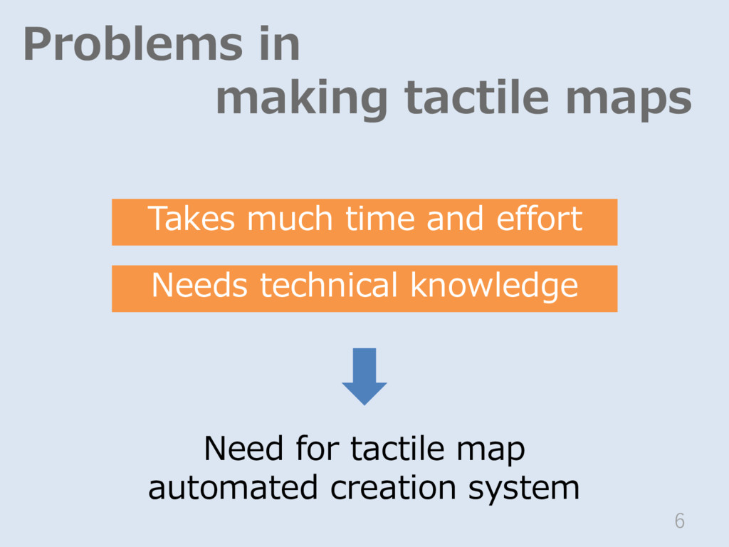
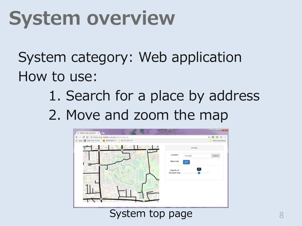
    Data *1 *1 *2 *1 Graduate School of Science and Technology University of Niigata *2 Faculty of Engineering, University of Niigata Implementation of a Contents Change Function According to the Scale ◦Chiharu BABA ◦Toshimitsu YAMAGUCHI ◦Tetsuya WATANABE 1
  2. Importance of maps • Know unfamiliar places • Know uncertain

    places • Recall the routes • etc. 2 The same roles apply to blind persons OSM of Tsurugajo Castle
  3. How monochrome image is created Step 1. Download a map

    image Step 2. Trace roads in black (with drawing software) Step 3. Put tactile patterns and symbols 5
  4. Problems in making tactile maps 6 Takes much time and

    effort Needs technical knowledge Need for tactile map automated creation system
  5. System overview System category: Web application How to use: 1.

    Search for a place by address 2. Move and zoom the map 8 System top page
  6. Top page OSM map object Tactile map image Setting panel

    9 Settings Location Base map Opacity of the base map Search OFF
  7. System block diagram Top page (HTML) JavaScript Mapfile ① MapServer

    ③ Web API Map data (OSM data) ② Sever Client Google Maps API (Geocording) OpenLayers (Display Map) OpenStreetMap (Map Object) 10
  8. Conversion of OSM data Convert OSM data to GIS database

    by osm2pgsql 11 Download site DB OSM file (XML format) osm2pgsql
  9. Characteristics of the system 1. Maps can contain information useful

    for blind people 2. Wide area images are readable by touch 12
  10. Information useful for blind pedestrians • Tactile paving • Obstruction

    • Signal with sound • Change of the sidewalk surface 14 OpenStreetMap General map data
  11. Merits of using OSM data 1. Arbitrary information can be

    registered - such as tactile pavement 2. Covers the globe 3. Free 15
  12. Map features Key Value Tactile pavement tactile_ paving yes Obstructions

    barrier block bollard cycle_barrier Data useful for blind people 16
  13. Wide area images 18 Select roads to display according to

    the scale A gap of at least 3 mm between the roads is necessary Too many objects
  14. Tactile symbols 19 Type of symbols Objects Images Line Road

    Huge Large Normal Small Road with tactile paving Railway River Area Water area Station Point Traffic signals Obstacle
  15. Select roads to display Road type 1/2500 1/5000 1/10000 Huge

    ◦ ◦ ◦ Large ◦ ◦ ◦ Normal ◦ ◦ ― Small ◦ ― ― ※ Other objects are displayed in all scales 20
  16. Select roads to display Road type 1/2500 1/5000 1/10000 Huge

    ◦ ◦ ◦ Large ◦ ◦ ◦ Normal ◦ ◦ ― Small ◦ ― ― ※ Other objects are displayed in all scales 21
  17. Select roads to display Road type 1/2500 1/5000 1/10000 Huge

    ◦ ◦ ◦ Large ◦ ◦ ◦ Normal ◦ ◦ ― Small ◦ ― ― ※ Other objects are displayed in all scales 22
  18. 24

  19. Add more information on the tactile map Less key:tactile_paving and

    key:barrier is registered 29 More data useful for blind people
  20. Add entrance symbols on the tactile map 30 More key:entrance!

    Blind people hardly find an entrance ? ? ? ?
  21. Classify roads by width MAPPLE 10000 OSM data New system

    Old system 2mm 3mm 31 Add width data at roads
  22. Create a map wherever user needs More object data at

    all area evenly Rural area have only poor data OSM Google Map